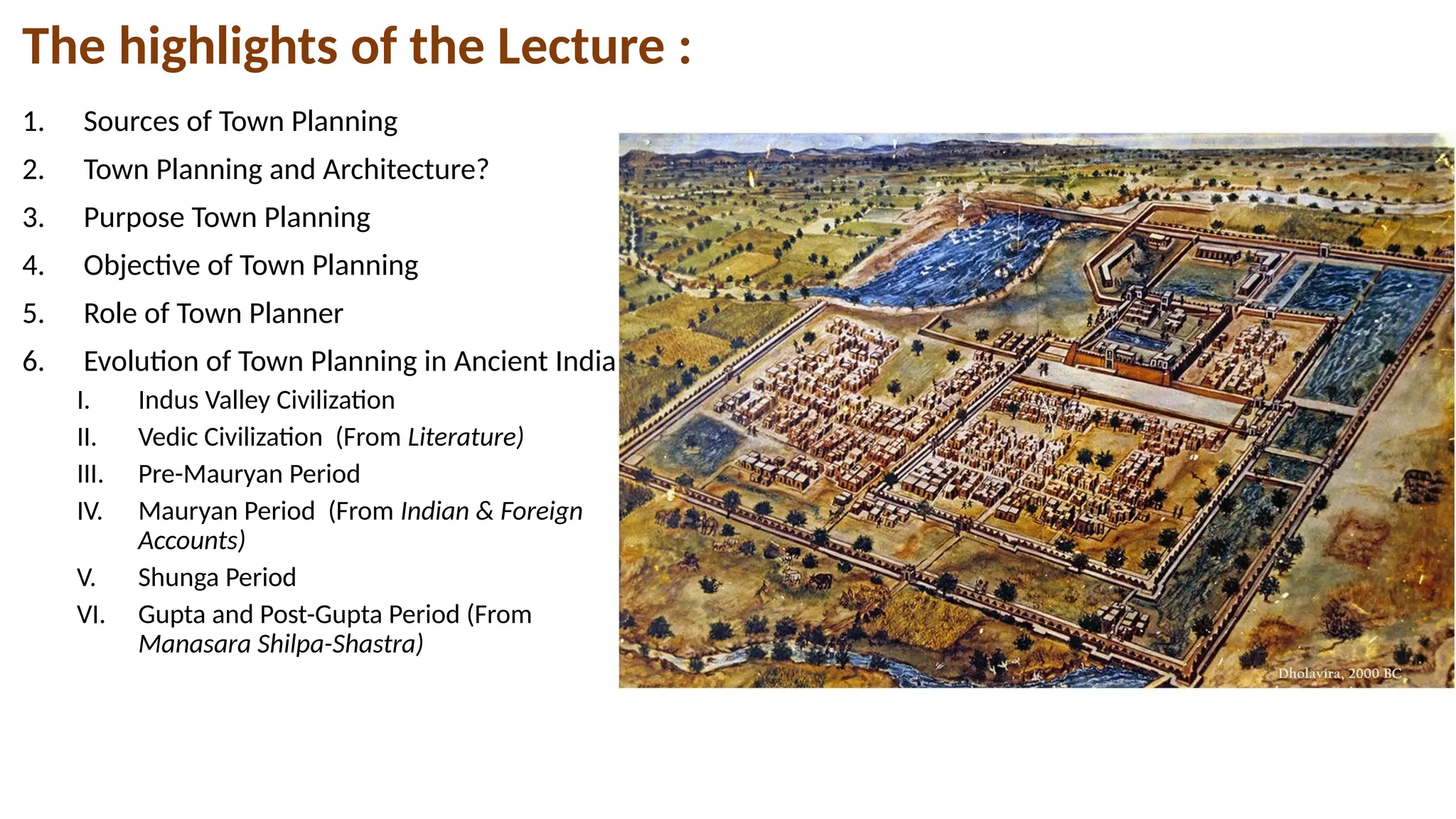
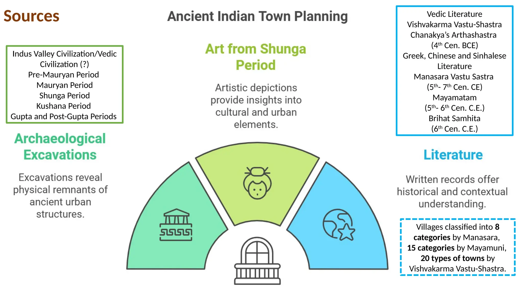
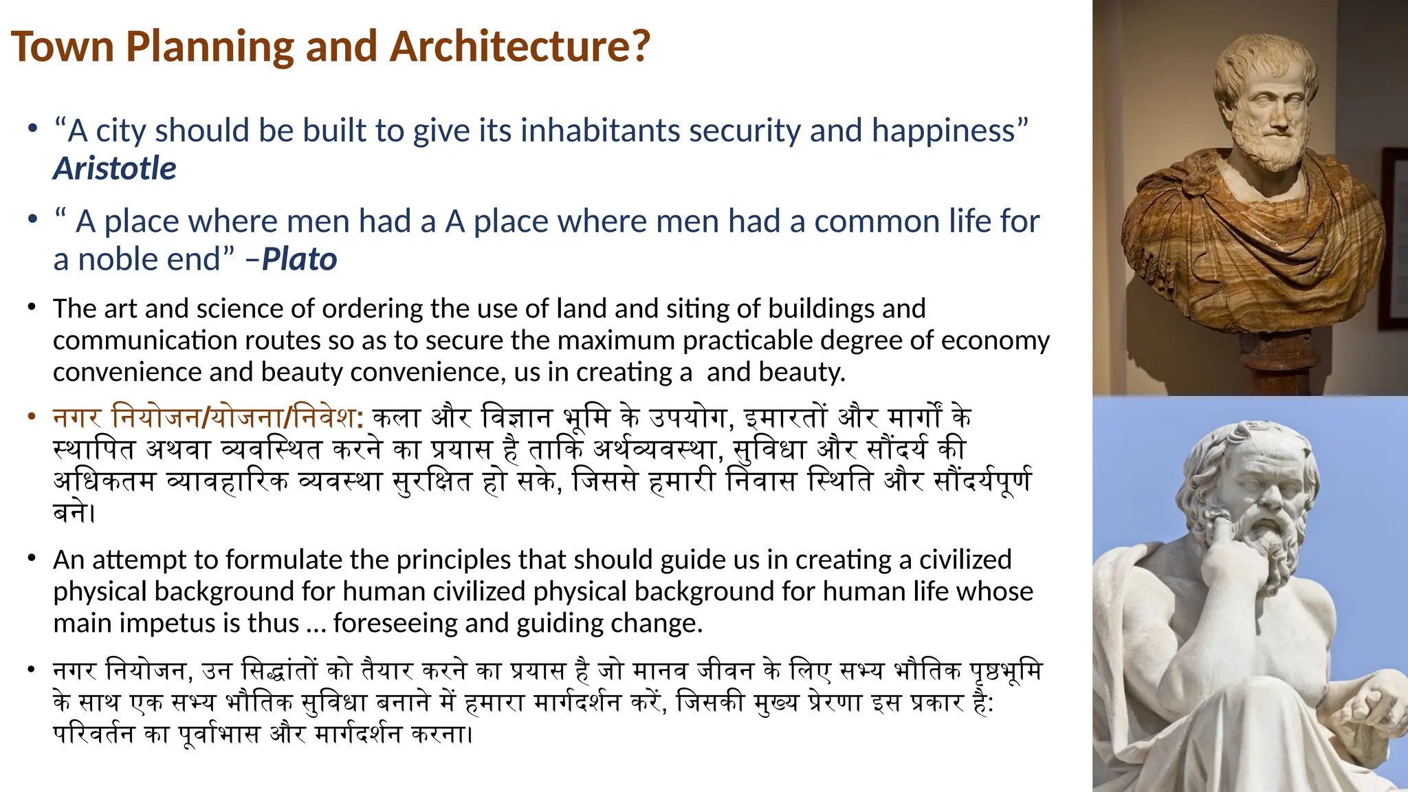
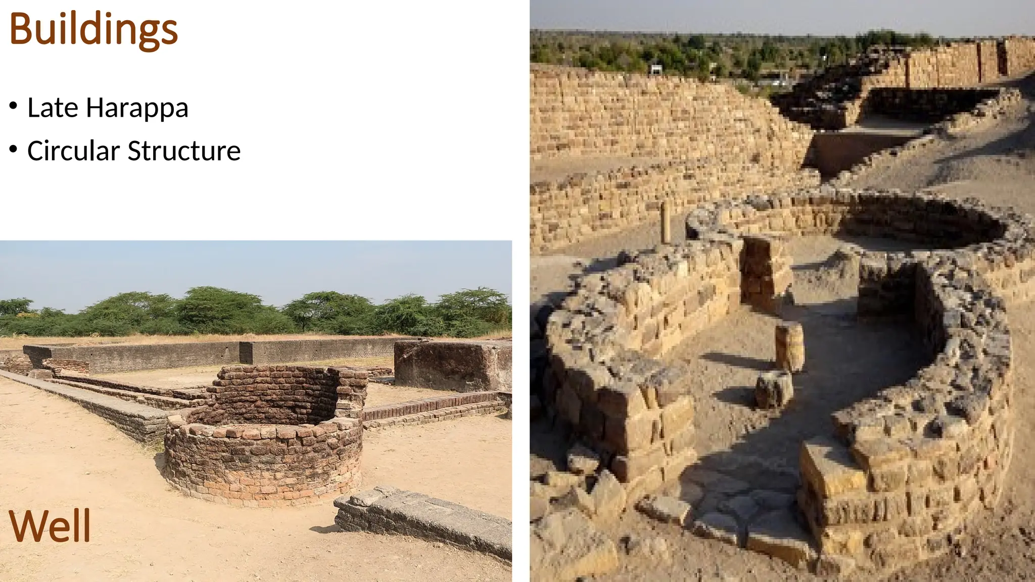
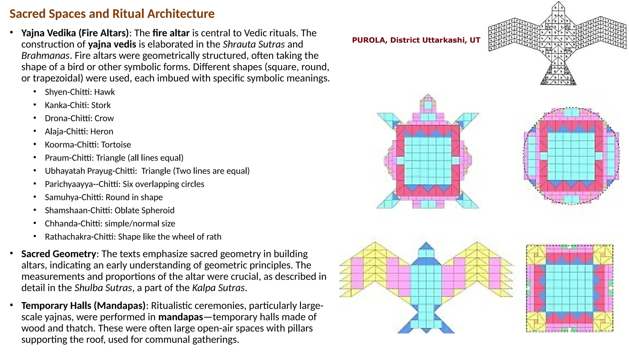
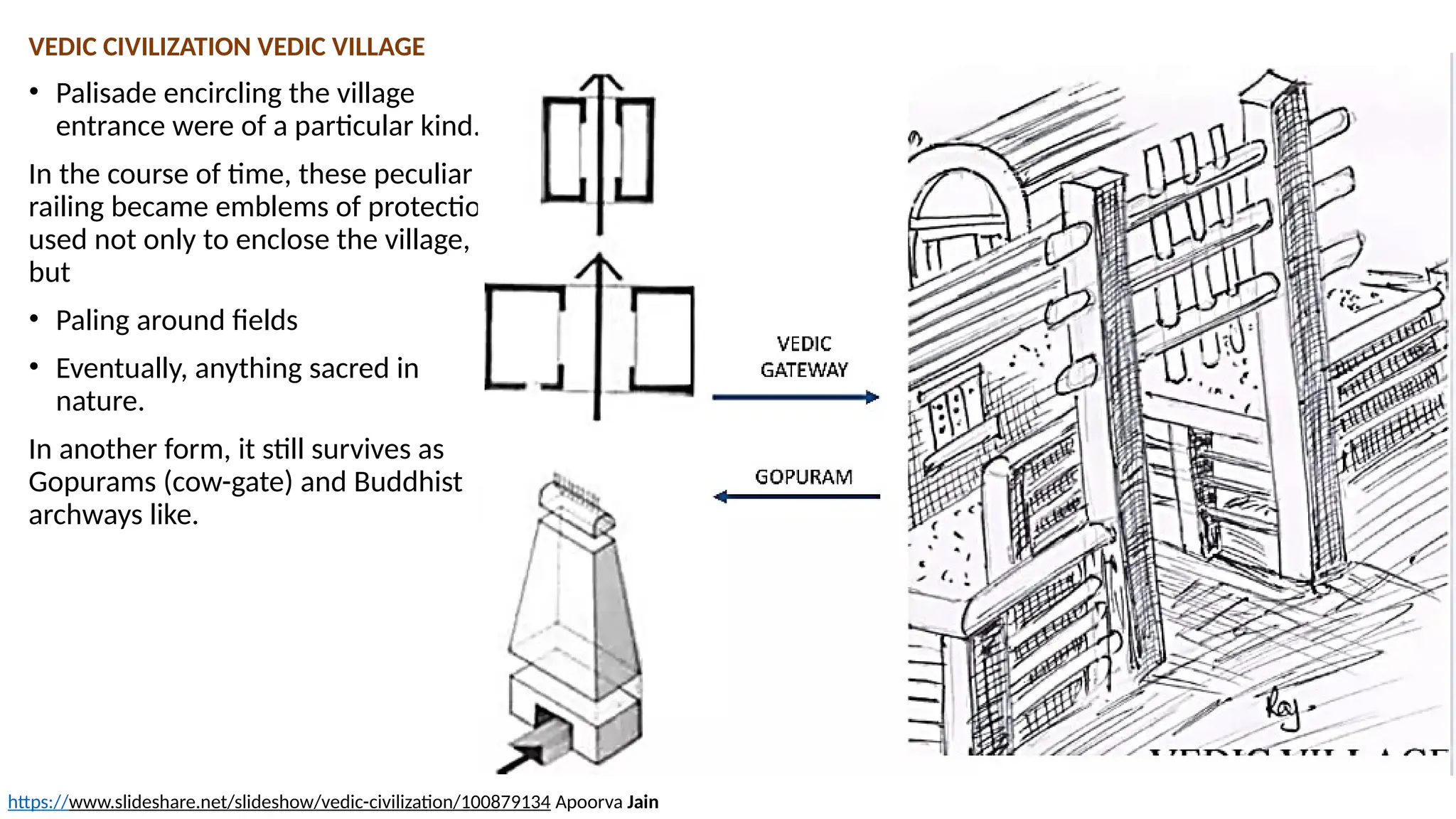
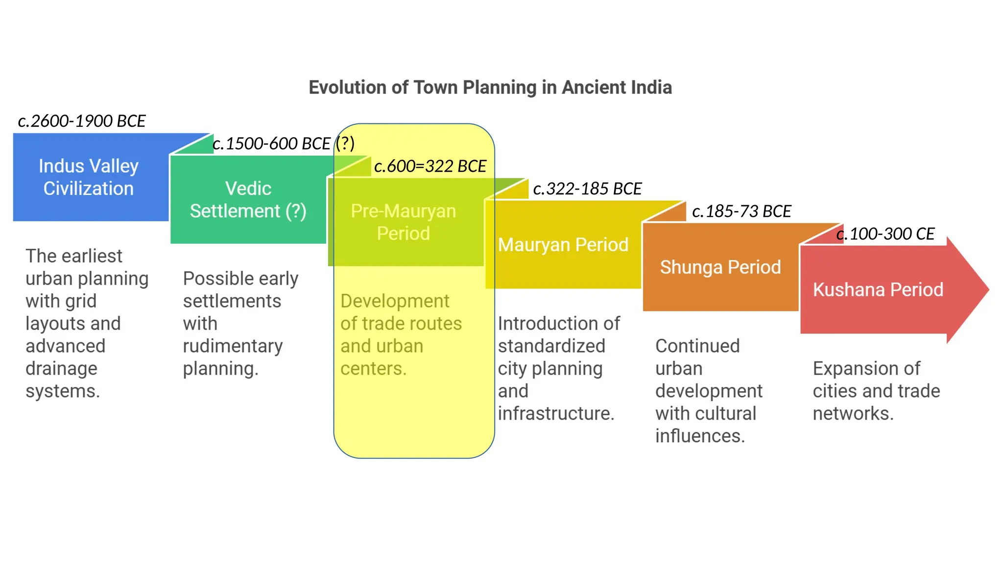
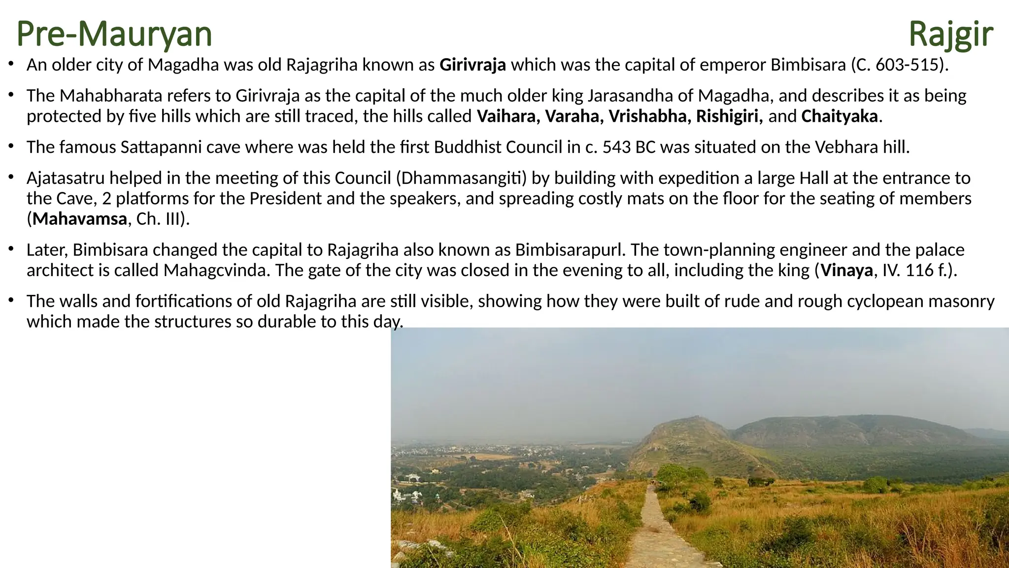
Principles of Town Planning in Ancient Indian
Sachin Kr. Tiwary
What is
History
इतिहास बीती हुई उन घटनाओं का
अध्ययन है जिसने व्यक्ति विशेष अथवा
परिस्थिति विशेष को प्रभावित किया
हो और जिसका पूर्ण अथवा आंशिक
प्रभाव किसी व्यक्ति, समाज, क्षेत्र, देश,
और काल पर पड़ा हो।
History is the study of past events
that have affected a particular
person or situation and which has
had a full or minor impact on a
person, society, region, country,
and period.
Divisions of India HISTORY
1. Ancient History
(From birth of human to 12th
-13th
Cen. CE)
2. Medieval History (8th
/ 12th
Cen. to 712 AD,
The first Muslim attack on India in Sindh in the year 712 A.D
was by Arabs led by Md Bin Qasim to Battle of
Plassey 1757/Last Mughal Ruler Bahadur Shah II 1857)
SULTANATE AND MUGHALS
3. Colonial History
1434 to 1947
Austrian, Swedish, Dutch, Danish, French,
Portuguese, British
4. Modern History
1947 TO TILL DATE
Ancient History
1. Stone Age/Pre-History (From First stone tool (3 lakh 84
thousands) till the introduction of Indus Valley-Civilization c.6000 BCE)
2. Bronze Age/Proto-History (From Indus Valley Civilization c.
6000 BCE to the introduction of Iron 2000 BCE)
3. Iron Age- Historical Phase
1. Pre-Classical Period (c. 600 BCE–200 CE)- Pradyot Dynasty to
Indo-Sythian Dynasty
2. Classical Period (c. 300–550 CE)- From Gupta-Vakataka Dynasty to
the Maukhari in the north and Pallva in the south.
3. Early Medieval Period (600/750-1200 CE): The early medieval
period of India was a transition between the ancient and medieval
periods, and lasted from approximately 600–1200 CE. It was
characterized by the formation of regional states, and the decline of
the Gupta Empire led to the emergence of regional powers in both
the north and south of the country.
The highlights of the Lecture :
1. Sources of Town Planning
2. Town Planning and Architecture?
3. Purpose Town Planning
4. Objective of Town Planning
5. Role of Town Planner
6. Evolution of Town Planning in Ancient India
I. Indus Valley Civilization
II. Vedic Civilization (From Literature)
III. Pre-Mauryan Period
IV. Mauryan Period (From Indian & Foreign
Accounts)
V. Shunga Period
VI. Gupta and Post-Gupta Period (From
Manasara Shilpa-Shastra)
Indus Valley Civilization/Vedic
Civilization (?)
Pre-Mauryan Period
Mauryan Period
Shunga Period
Kushana Period
Gupta and Post-Gupta Periods
Vedic Literature
Vishvakarma Vastu-Shastra
Chanakya’s Arthashastra
(4th
Cen. BCE)
Greek, Chinese and Sinhalese
Literature
Manasara Vastu Sastra
(5th
- 7th
Cen. CE)
Mayamatam
(5th
- 6th
Cen. C.E.)
Brihat Samhita
(6th
Cen. C.E.)
Villages classified into 8
categories by Manasara,
15 categories by Mayamuni,
20 types of towns by
Vishvakarma Vastu-Shastra.
Sources
Town Planning and Architecture?
• “A city should be built to give its inhabitants security and happiness”
Aristotle
• “ A place where men had a A place where men had a common life for
a noble end” –Plato
• The art and science of ordering the use of land and siting of buildings and
communication routes so as to secure the maximum practicable degree of economy
convenience and beauty convenience, us in creating a and beauty.
• नगर नियोजन/योजना/निवेश: कला और विज्ञान भूमि के उपयोग, इमारतों और मार्गों के
स्थापित अथवा व्यवस्थित करने का प्रयास है ताकि अर्थव्यवस्था, सुविधा और सौंदर्य की
अधिकतम व्यावहारिक व्यवस्था सुरक्षित हो सके, जिससे हमारी निवास स्थिति और सौंदर्यपूर्ण
बने।
• An attempt to formulate the principles that should guide us in creating a civilized
physical background for human civilized physical background for human life whose
main impetus is thus … foreseeing and guiding change.
• नगर नियोजन, उन सिद्धांतों को तैयार करने का प्रयास है जो मानव जीवन के लिए सभ्य भौतिक पृष्ठभूमि
के साथ एक सभ्य भौतिक सुविधा बनाने में हमारा मार्गदर्शन करें, जिसकी मुख्य प्रेरणा इस प्रकार है:
परिवर्तन का पूर्वाभास और मार्गदर्शन करना।
• Purpose: Balancing physical growth,
environment, and societal needs.
• Definition of Town Planning: "The art of
shaping and guiding the physical growth of
towns and cities."
Objective:
1. To meet various needs: social, cultural, economic,
recreational, etc.
2. Provide healthy living conditions for all—rich and
poor alike.
3. Promote social and economic well-being for the
majority of people.
4. Promote healthy environments.
5. Ensure effective zoning and orderly development.
6. Provide social and recreational amenities.
7. Preserve cultural individuality and aesthetic
values.
Town Planning and Architecture?
Ancient Indian Context:
c.2600-1900 BCE
c.1500-600 BCE (?)
c.600=322 BCE
c.322-185 BCE
c.185-73 BCE
c.100-300 CE
• One of the world's
earliest and most
developed civilizations
was the Harappan
civilization.
• The cities were developed
and well-planned. A
wooden screen was
placed at the end of the
main sewer to show they
were equally concerned
about water
contamination.
• Waste collection and
disposal were also carried
out adequately.
• Burned bricks and a well-
drained system were
used to construct streets
in the same engineering-
based fashion.
Unique
feature
Streets
Drainage
System
The Great
Bath
Granaries
Dockyard
Buildings
Fortification
Fortification
Hearth
Well-
Sanitaion
Used
Material
Bitumen
Gypsum
Wood
Sun Dried
Brick
Undressed
Stone
Dressed
Stone
Burned
Brick
1:2:4 ratios
Mud mortar and gypsum cement
Wedge Shape Bricks
Interlocking Pattern
Harappa
Harappa
Kalibanga
Kalibanga
Kalibanga
Bhogavo river
Bhogavo river
Town Planning & Structures
• The Harappan civilisation was characterised by its grid-based town planning system, in which streets and alleys cut
across one another virtually at right angles, separating the city into many rectangular blocks.
• Harappa, Mohenjodaro, and Kalibangan each had their own castle erected on a high mud-brick pedestal.
• Each city has a lower town with brick buildings occupied by the ordinary people beneath the castle.
• The Harappan civilisation is distinguished by the widespread use of burned bricks in practically all types of
architecture and the lack of stone structures.
• Another notable feature was the underground drainage system that connected all dwellings to street drains that
were covered by stone slabs or bricks.
• The Great Bath, which is 39 feet long, 23 feet wide, and 8 feet deep, is Mohenjodaro's most significant public space.
• A flight of steps leads to the surface at each end. There are separate dressing rooms. The Bath's floor was
constructed of charred bricks.
• The biggest structure at Mohenjodaro is a granary 150 feet long and 50 feet wide.
• However, there are as many as six granaries in Harappa's fortress.
Streets and Roads
• Indus Valley's streets and roadways were all straight
and intersected at a right angle.
• All of the roadways were constructed with burned
bricks, with the length of each brick being four times
its height and the breadth being two times its
height.
• They ranged in width from 13 to 34 feet and were
fully lined.
• The city was split into rectangular blocks by the
streets and roadways.
• Archaeologists unearthed the lamp posts at regular
intervals. This implies the presence of street lighting.
• On the streets, there were also trash cans. These
demonstrate the presence of competent municipal
management.
Drainage system
• One of the most notable elements of the Indus Valley
civilization was the city's efficient closed drainage system.
• Cities of the Indus Valley Civilization possessed sophisticated
water and sewage systems.
• Many Indus Valley sites have houses with single, double, and
more rooms coupled to a very effective drainage system.
• Each residence had its own drainage and soak pit that was
linked to the public drainage system.
• Every roadway was lined by brick-paved canals.
• They were covered and had manholes at regular intervals for
cleaning and clearing.
• To convey extra water, large brick culverts with corbelled
roofs were built on the city's outskirts.
• As a result, the Indus people developed a flawless subsurface
drainage system.
• No other modern culture paid such close attention to hygiene.
• Corbelled drains were the primary method of collecting waste
and rainfall; they may also have been used to empty
enormous pools used for ceremonial washing.
Great bath
• The Great Bath is the most notable feature of Mohenjodaro. It
is made up of a big quadrangle.
• The discovery reveals that the Great Bath, which was located
within the city, was a huge rectangular tank used for special
rites or ceremonial bathing and resembled a modern-day
swimming pool.
• There is a large swimming pool in the centre (about 39 feet
long, 23 feet wide, and 8 feet deep) with the ruins of galleries
and chambers on all four sides.
• It features a flight of stairs at either end and is supplied by a
well in one of the neighbouring apartments.
• The water was released through a massive drain with a
corbelled ceiling that was more than 6 feet deep.
• The Great Bath's outside walls were 8 feet thick.
• To prevent water leakage, the tank was covered with gypsum.
• For 5000 years, this sturdy structure has resisted the assaults of
nature.
• Some rooms were equipped with hot water baths.
General Conference Hall
• Adjacent to the Great Bath of Mohenjo-Daro was discovered a sprawling house, 230 feet long and 78 feet wide,
and with a 33 feet verandah attached to it. The house was propped up by wooden pillars. Historians differ as to
the purpose for which the house was built. While some of them term it as the general conference hall, others
describe it as the residential quarters of high officials.
Granaries
• The granary, which is 45.71 metres long and 15.23
metres broad, is the biggest structure at Mohenjodaro.
• Harappa has a set of brick platforms that served as the
foundation for two rows of six granaries each.
• Brick platforms have also been discovered in the
southern section of Kalibangan.
• These granaries protected the grains, which were most
likely gathered as income or as storehouses to be used
in crises.
• During disasters, most staple foods like rice, wheat, and
barley were stockpiled in these warehouses for public
distribution.
• The cervical granaries were a massive building.
• Archeological evidence suggests that the lowest half of
the stockroom was formed of blocks, while the upper
part was most likely made of wood.
Other Buildings
• People from the Indus Valley civilisation erected dwellings and other structures
beside highways.
• They constructed terraced dwellings out of charred bricks. Every dwelling had at
least two rooms.
• There were also multi-story buildings.
• The buildings were built around an inner courtyard and had pillared
hallways, bath rooms, paved floors, a kitchen, a well, and other amenities.
• There are also workmen's quarters.
• It had an outstanding water supply system.
• There were public wells throughout the streets.
• Each large residence has its own well.
• The majority of the residences in the Lower Town featured a central courtyard
surrounded by rooms.
• Summer activities like cooking and knitting were most likely done in the
courtyard.
• To promote privacy, the main entrance was usually located so that it did not
provide a direct view of the inside.
• Furthermore, there were no windows on the ground-level walls of the dwellings.
Buildings
• Late Harappa
• Circular Structure
Well
Wells &
Sanitation
c.2600-1900 BCE
c.1500-600 BCE (?)
c.600=322 BCE
c.322-185 BCE
c.185-73 BCE
c.100-300 CE
Thes
VEDIC CIVILIZATION
• Towards the middle of the first millennium
BC, the social system expanded, and
towns arose at certain imp centers and
were reproduced at a larger scale and
more substantial form.
I. Strongly fortified
II. Surrounded by ramparts and wooden
palisades
III. Buildings are almost always made of
wood
• It is not surprising, therefore, that in later
times, timber construction techniques
were employed even though the material
of construction was radically different—
i.e.,. stone.
Era of Timber Construction
VILLAGE OF VEDIC CIVILIZATION
Primary Building Material:
• Wood as Primary Material: The Vedic period heavily relied on wooden architecture. References
to wooden poles (yupa), beams (kulya), and platforms (vedi) indicate the use of timber for
constructing various structures.
• Mud and Clay: Simple mud huts were prevalent, with thatched roofs made from straw or leaves.
These huts were used for both living spaces and religious activities.
• Temporary Structures: Since Vedic society was primarily semi-nomadic, the architecture was
simple and often temporary, allowing for quick dismantling and rebuilding.
• The aryan hut in its most basic shape was circular in plan with a thatched roof over a network of
bamboo ribs.
• Cluster of these huts formed a courtyard.
• To protect themselves and their property from the ravage of wild animals, they have surrounded
their collection of huts with a special kind of fence or palisade. Huts were arranged in threes and
fours around the square courtyard.
Type of Housing
• Circular Hut: The most elementary hut was circular in plan. This was the simplest to construct
with bamboo and thatch. But they had functional limitations.
• Rectangular Hut: The circular hut was added and changed to an elastic hut. The huts were
arranged in groups of three or four around the local courtyard.
• The village was safe from wildlife by a timber fence.
• Gateway was installed in front of the entry portion to provide a controlled entry. The cities of the
Vedic period were rectangular in plan and divided into 4 quarters by two main thoroughfares
intersecting at right angles, each leading to a city gate. One of these quarters contained the
citadel and another housed the residential area.
Sacred Spaces and Ritual Architecture
• Yajna Vedika (Fire Altars): The fire altar is central to Vedic rituals. The
construction of yajna vedis is elaborated in the Shrauta Sutras and
Brahmanas. Fire altars were geometrically structured, often taking the
shape of a bird or other symbolic forms. Different shapes (square, round,
or trapezoidal) were used, each imbued with specific symbolic meanings.
• Shyen-Chitti: Hawk
• Kanka-Chiti: Stork
• Drona-Chitti: Crow
• Alaja-Chitti: Heron
• Koorma-Chitti: Tortoise
• Praum-Chitti: Triangle (all lines equal)
• Ubhayatah Prayug-Chitti: Triangle (Two lines are equal)
• Parichyaayya--Chitti: Six overlapping circles
• Samuhya-Chitti: Round in shape
• Shamshaan-Chitti: Oblate Spheroid
• Chhanda-Chitti: simple/normal size
• Rathachakra-Chitti: Shape like the wheel of rath
• Sacred Geometry: The texts emphasize sacred geometry in building
altars, indicating an early understanding of geometric principles. The
measurements and proportions of the altar were crucial, as described in
detail in the Shulba Sutras, a part of the Kalpa Sutras.
• Temporary Halls (Mandapas): Ritualistic ceremonies, particularly large-
scale yajnas, were performed in mandapas—temporary halls made of
wood and thatch. These were often large open-air spaces with pillars
supporting the roof, used for communal gatherings.
PUROLA, District Uttarkashi, UT
VEDIC CIVILIZATION
VEDIC VILLAGE: Planning
The village's planning was organic, as it was planned
according to the User groups/varnas' functions in the
Society.
Society was divided into the four varnas:
• The Brahmans, who were the center of all knowledge,
• The Kshatriyas, who were the controllers of political
power,
• The Vaishyas, who were tradesmen and farmers and
the
• The Shudras, who were the artisans and the
craftsmen.
THE CITIES OF THE VEDIC PERIOD:
RECTANGULAR IN PLAN
DIVIDED INTO FOUR QUARTERS BY TWO MAIN
THOROUGHFARES INTERSECTING AT RIGHT ANGLES,
EACH LEADING TO A CITY GATE.
ONE QUARTER HAD CITADEL & ROYAL APPARTMENT.
Brahman
Kshatriya
Vaishya
Shudra
VEDIC CIVILIZATION VEDIC VILLAGE
• Palisade encircling the village
entrance were of a particular kind.
In the course of time, these peculiar
railing became emblems of protection,
used not only to enclose the village,
but
• Paling around fields
• Eventually, anything sacred in
nature.
In another form, it still survives as
Gopurams (cow-gate) and Buddhist
archways like.
https://www.slideshare.net/slideshow/vedic-civilization/100879134 Apoorva Jain
Sources of Information
The study of Vedic religious architecture
draws from multiple sources such as:
• Excavations: Archaeological evidence
provides crucial insights into early
structures associated with Vedic rituals.
• Coins: Numismatic evidence from Punch
Marked Coins, Ujjain Coins, Copper Cast
Coins, and others also reflect symbolic
representations of Vedic architecture.
• Epigraphy: Inscriptions such as the
Mahasthana Inscription, Raibatak
Inscription, and Ashokan Edicts
document early architectural forms and
religious practices.
• Literature: Vedic texts like the Rigveda,
Kausitaki Upanishad, and Jaimini
Upanishad offer descriptions of sacred
spaces, temples, and shrines, often
referred to by various names.
Vedic Religious Architecture: A Systematic Overview
•Panini (4th century BCE) and Patanjali
(2nd century BCE) mention Vedic deities
and images used for worship in shrines.
•Kautilya’s Arthashastra (3rd century BCE)
refers to temples dedicated to deities like
Shiva, Vishnu, and Lakshmi.
Synonyms of Temples and Sacred Structures in Vedic Texts In Vedic
and post-Vedic literature, several terms are used to describe sacred spaces. These reflect the
evolution of religious architecture:
• Temple/Abode/Shrine: Generic terms for sacred places.
• Yaksha-sadam (Rigveda): Abode of the Yaksha.
• Deva-Mana (Rigveda): Abode of the Deva (god).
• Devasya-Sadama (Rigveda): Residence of a deity.
• Aayatanam (Kausitaki Upanishad, Jaimini Upanishad): A term meaning "abode."
• Devasthana, Devagraha, Devakulam, Devakula, Devatagriha: Various terms for temple or
place of worship.
• Prasaad, Prasaado, Bhagava-Prasaad: Temple or sacred abode (seen in later texts).
• Mahasthaan, Toran Vedikaa, Chatuhsaalam: Terms describing architectural features.
• Shaila-Devagriha (Mora Well Inscription): Stone temple.
• Veyaddhi Mancha: A stone tablet or altar.
• Yajna Shala (Sathapatha Brahmana): A place for conducting Yajnas or sacrifices.
• Gadhakuti Prasaad (Bodhgaya, Kushana Inscription): A large temple structure.
• Caitya-kuti (Mathura, Kushana Inscription): Sacred shrine or temple.
c.2600-1900 BCE
c.1500-600 BCE (?)
c.600=322 BCE
c.322-185 BCE
c.185-73 BCE
c.100-300 CE
Pre-Mauryan Rajgir
• An older city of Magadha was old Rajagriha known as Girivraja which was the capital of emperor Bimbisara (C. 603-515).
• The Mahabharata refers to Girivraja as the capital of the much older king Jarasandha of Magadha, and describes it as being
protected by five hills which are still traced, the hills called Vaihara, Varaha, Vrishabha, Rishigiri, and Chaityaka.
• The famous Sattapanni cave where was held the first Buddhist Council in c. 543 BC was situated on the Vebhara hill.
• Ajatasatru helped in the meeting of this Council (Dhammasangiti) by building with expedition a large Hall at the entrance to
the Cave, 2 platforms for the President and the speakers, and spreading costly mats on the floor for the seating of members
(Mahavamsa, Ch. III).
• Later, Bimbisara changed the capital to Rajagriha also known as Bimbisarapurl. The town-planning engineer and the palace
architect is called Mahagcvinda. The gate of the city was closed in the evening to all, including the king (Vinaya, IV. 116 f.).
• The walls and fortifications of old Rajagriha are still visible, showing how they were built of rude and rough cyclopean masonry
which made the structures so durable to this day.
A painting from the Mahabharata India, Kangra or Garhwal, circa 1810-20
Md. H. Kuraishi
https://ignca.gov.in/Asi_data/1190.pdf
The Great Cyclopean Wall
Pre-Mauryan stone structure made of massive undressed rocks fitted together with small stone
fragments packing the interstices between them was once 40 km long and encircled Rajgir.
Entry Gate
Gijjhakuta
Battle Ground of Jarasandh
Ajatshatru Fort
Sonbhandar Cave
Sonbhandar Cave
Bimbisar Jail
The Maniyar Matth was once a monastery of a cult that worshipped snakes. This can be seen by
the figures of different snakes that are found here.
The Chariot Tracks
feature two parallel
furrows cut into the
rocks and are
believed to have
been made by Lord
Krishna's chariot.
Shell inscriptions are
also seen here
engraved on the
rocks.
c.2600-1900 BCE
c.1500-600 BCE (?)
c.600=322 BCE
c.322-185 BCE
c.185-73 BCE
c.100-300 CE
Sources
Kautilya
Arthashatra
Megathnese
Indica
Strabo
Geographica
Fa-Hien
Mahavansha
Vinay Pitaka
Architecture
Excavated
Remains
Art Objects
Town Planning during the Mauryan Period
• The hills of Barabar caves were donated by Ashoka to Ajivika monks
and three separate caves at Nagarjuni hills were by Dasharatha to
them.
Rock-cut Caves
• Kumrahar
• Bulandibagh
Palaces
• All around the north India located near Buddhist sites and territory
Free Standing Pillars
• 84,000 Stupa, Divyavadana
Stupas
Arthashatra
• https://csboa.in/eBooks/Arthashastra_of_Chanakya_-_English.pdf
• https://archive.org/details/kautilyasarthasastraenglishtranslationshamasastrir.1929/page/n33/mode/2up?view
=theater
• https://ncjindalps.com/pdf/HUMANITIES/The%20Kautilya%20Arthashastra%20-%20Chanakya.pdf
Book:I Chapter XIX
Book:II Chapter III, IV, V
Book:X Chapter I
Chanakya’s Thoughtss on Town and
Country Planning
Chanakya's Vision of Town Planning (From Arthashastra)
Congested Towns and New Settlements
o Overpopulated towns should relocate surplus population to new settlements.
o New settlements should be strategically placed to help each other.
o Tax exemptions for new settlers for the initial years.
o Higher proportion of agriculturists and shudras in new villages.
Village Administration Structure
 Administrative Hierarchy:
o Sangrahan (10 villages)
o Sarvatik (200 villages)
o Dronamukh (400 villages)
o Sthaniya (800 villages)
Infrastructure Guidelines for New Villages
Essential Infrastructure:
o Markets for highway traders.
o Dams over rivers and nalas.
o Temples and gardens for recreation and worship.
o Care arrangements for the aged, children, and informal persons.
From Arthashastra
Agricultural Focus
o Continuous engagement of agriculturists ensures
growth in cereals and wealth.
o Protection and enhancement of quarries, forests,
and canals.
City Planning Guidelines
Location:
o The central part of the country facilitates trade
and commerce.
o A large area near a perennial river or lake.
Shape:
o Circular, rectangular, or square depending on the
topography.
o Surrounded by water on all sides.
City Layout Design
o Walls: At least 6 dandas high and 12 dandas
wide.
o Moats: Three moats (14 ft, 12 ft, 10 ft wide) with
a depth of ¾ width.
o Roads: 3 East-West and 3 North-South roads.
Main roads 8 dandas wide, others 4 dandas.
https://architexturez.net/doc/10-1080/00369227808736393
Chanakya's Vision of Town Planning (From Arthashastra)
Palace Location:
oThe central part of the city faces north or east.
Residential Segmentation:
oSoutheast: Priests and ministers.
oEast: Traders, skilled workers, and Kshatriyas.
oSouth: Treasury, goldsmiths, and industries.
oNortheast: Forest produce storage.
oSouth: Doctors, artists, and army commanders.
o Depressed classes: Beyond cemeteries.
Essential City Features
oTemples: Temples in the town centre are similar to the Vedic tradition.
oCemeteries: North and east for higher castes, south for lower castes.
oWells: One for every group of 10 houses.
Chanakya's Vision:
oA blend of practical governance, strategic planning, and social harmony.
oFocus on trade, agriculture, and equitable living standards.
Relevance Today:
oPrinciples applicable to modern urban planning and sustainable development.
Chanakya's Vision of Town Planning (From Arthashastra)
Interestingly, it is believed that Buddha, on his way from
Rajgir to Vaishali, passed by this town and predicted that
it was destined to become a great city.
In the Patali Sutta which forms part of the Khuddaka
Nikdya, the Buddha is quoted as saying that-
“Pataliputra will emerge as a great metropolis and also
that its three enemies will be flood, fire and invasion”
In the Digha Nikaya, the Buddha confides to his favourite
disciple, Ananda, that as far as the Aryans dwell and as
far as the merchants travel, Pataliputra will be the
foremost city.
The words of the prophecy, as given by British explorer Col
Laurence Waddell, were as follows:
“Among famous palaces, busy marts and emporiums,
Pataliputra will be the greatest; (but) three perils will
threaten it – fire, water and internal strife.”
Lord Buddha’s Opinion:
Evidence of Fire and Flood in the archaeological and textual records
• Excavated Sites in Patna:
• Kumrahar
• Bulandibagh
• Lohanipur
• Menander attacked Pataliputra and set it on fire. The deposit
of one foot thick ashy layer overlying the Sunga habitational
level at Kumrahar is cited as the proof of this fire.
• Altekar preferring the year C.E. 575. Sone floods in 1975 only
needs to be recollected to appreciate the extent of
devastation which could be caused by 17days of continuous
downpour with both Ganga and Sone in high floods.
• According to a Jain tradition recorded in the Tithlogali, a Jain
teacher had forecast that a devastating flood would engulf
and destroy the whole city. The ascetic who made this
prediction advised the Jain monks to move out in search of
safer places. Soon afterwards, it began to rain heavily. The
rains continued unabated for 17 days and nights.
Consequently, the rivers Ganga and Sone began to overflow
the banks, Sone being particularly furious. From a
synchronization of literary references to Pataliputra it would
appear that this devastation took place towards the close of
the 6th century C.E.
…the City had two grand monasteries-one of the Hinayana and other of
the Mahayana. He noticed the usual grandeur of Ashoka’s Palace as
such. People living there were quite prospered by all means.
There was an excellent hospital run by the wealthy citizens of the town.
Rest-houses existed in large towns and on highways for the comforts of
the travelers. The relations between the followers of various sects
were cordial.
He mentioned the elegant carving and inlay wood sculpture work of the
buildings, “in a way that no human hands of this world could
accomplish”.
Fa-Hien spent 10 years in India. For 3 years in Pataliputra for Sanskrit
knowledge.
c.399 -412 CE
Book Name: Foguoji (A Record of Buddhistic Kingdoms; also known
as Faxian's Account)
According to the Greek writers:
• Punjab was full of towns.
• Many of these figures as forts or centres of defence,
such as the famous Massaga (Masakavati) or Aomos
(Varana) in the country of the Asvakas already
referred to.
• The free clan called the Glaussai had as many as 37
towns in their territory, while there were as many as
5,000 towns in the territories of the other peoples,
the Malloi, Oxydrakai, and others.
• The smallest of these towns contained at least 5,000
inhabitants, while many contained upwards of
10,000. Some of the villages were not less populous
than towns.
Megasthenes
“ The greatest city in India is that which is called Palimbothra, in
the dominions of the Prasians, where the streams of the
Eranno- boas (this is Greek corruption for Hirannavati, modem
Sone) and the Ganges unite.... This city stretched in the
inhabited quarters to an extreme length on each side of 80
stadia (nearly ten miles), and its breadth was 15 stadia (nearly
two miles), and a ditch encompassed it all round, 600 feet in
breadth and 30 cubits in depth, and the wall was crowned with
670 towers and four-and-sixty gates.”
“ The royal palace which occupied a central position and placed
in a fine wooden park laid out with fountains and fish ponds,
was described by Megasthenes as being more splendid than
those of Susa and Ecbatana. Its pillars were plated with gold,
and it was magnificently furnished with thrones and chairs of
state, and great vessels of gold, silver, and copper set with
precious stones.”
“Of their cities, it is said that the number is
so great that it cannot be stated with
precision, but that such cities as are
situated on the banks of rivers or on the
sea-coast are built of wood, for where
they are built of brick they would not last
long-so destructive are the rains, and
also the rivers when they overflow their
banks and inundate the plains. Those
cities, however, which stand on
commanding situations and lofty
eminences are built of brick and mud”.
Megasthenes travelled to India as an ambassador for Greek
ruler Seleucus I Nikator between 302 and 288 BC.
Inscriptions of Asoka:
• The following chief cities of the Maurya empire mentioned:
Pataliputra, Bodh-Gaya, Kosambi, Ujjeni, Takkhasila, Suvarnagiri,
Isila, Tosali, & Samapa. These cities were the capitals of the
provinces, the headquarters of the local administrations, or
centres of pilgrimage.
• Other towns which were populous and selected for that reason for
the location of his inscriptions by Asoka were Shahbazgarhi and
Mansehra, Kalsi, Sopara, Girnar, Jaugada, Dhauli, Chitaldroog,
Rupnath, Sahasram, Bairat (Bhabru), Maski, Govimath &
Palkigundu in Kopbal District & Gooty in Kurnool district.
• The names of these places are not Maurya but modem names and
most of these are now out of the way and deserted places, and not the
centres of population and civilisation as they were in Maurya India. The
course of civilisation changes through the ages.
Strabo (c.64 BCE-21 CE),
the Greco-Roman geographer in his book Geographia
"At the confluence of the Ganges and of
another river is situated Palibothra (as the
Greeks called Pataliputra), in length 80, and in
breadth 15 stadia. It is in the shape of a
parallelogram, surrounded by a wooden wall
pierced with openings through which arrows
may be discharged. In front is a ditch, which
serves the purpose of defence and of a sewer
for the city.“
570 towers and 46 gates
According to Strabo:
• In the territories of 9 nations between the Jhelum and the Beas there were as many as
500 cities.
• Taxila was “a great and flourishing city, the greatest, indeed, of all the cities which lay
between the Indus and the Hydaspes”.
• Some of the cities were remarkable for the design shown in town-planning and
architecture and for the strength of their fortifications. Message, for instance, was built up
as a fort commanding great natural advantages on an eminence inaccessible on all sides
against steep rock, treacherous morass, deep stream, and a rampart guarded by a deep
moat to boot. The rampart was “35 stadia (=about 4 miles) in circumference, with a basis
of stone­
work supporting a superstructure of unburnt, sun-dried bricks. The brick-work
was bound in a solid fabric by means of stones”.
• The fortress of Aornos was similarly constructed on a high hill, with its water-supply
arranged by tapping a local spring, and food grown with the labour of a thousand men in
an adjoining field to render the fort self-sufficient against a siege.
• It is stated that these forts were possessed of fortifications and battlements which were so
strong that Alexander had “to bring up military engines to batter down their walls” (Ib. p.
67). The Kathaians had a strongly fortified city called Sangala with its walls made of brick.
• The Malloi had also many walled cities with citadels on commanding heights and difficult
of access. Alexander had to apply scaling ladders on all its sides and to undermine its
walls. The walls had towers at intervals. In scaling the walls, Alexander was assailed from
every side from the adjacent towers.
Arrian (c.86-160 CE)
"Megasthenes says that on one side where it is
longest this city extends ten miles in length, and
that its breadth is one and three quarters miles;
that the city has been surrounded with a ditch in
breadth 600 feet, and in depth 45 feet; and that
its wall has 570 towers and 64 gates.”
Excavation
David Brainard Spooner excavated Pataliputra with the funds donated by Sir Ratan Tata (February 7, 1879 - January
30, 1925) ASIEC (Archaeological Service of India), published 1912-1913 - Kumhrar Maurya level ASIEC 1912-1913,
vol. 1, pl. 1029
• ‘Mr Ratan Tata’s Excavations at Pataliputra’ began with a cheque for Rs 15,000, after the discovery of the ‘Hall of
Ashoka.’ Over the years, more than Rs 60,000 was to be spent on these excavations, writes Prof. Nayanjyot
Lahiri.
• Excavations carried out by Spooner and Waddell have brought to light remains of huge wooden palisades
at Bulandi Bagh in Pataliputra.
• In this excavation traces of 72 pillars were found.
• Eight more pillars of the hall and four additional one belonging to the entrance or porch were exposed during
further excavation in 1951-55 by K. P. Jayaswal research institute, Patna. Since then it is popularly referred as the
‘assembly hall of 80-pillars’.
• The remains of one of the buildings, an 80 pillared hall at Kumrahar are of particular significance. Out of 80 stone
columns, that once stood on a wooden platform and supported a wooden roof, Spooner was able to discover the
entire lower part of at least one in almost perfect conditions.
• It is more or less similar to an Ashokan pillar, smooth, polished and made of grey Chunar sandstone.Many stupas
like those at Sanchi, Sarnath and possibly Amaravati Stupa were originally built as brick and masonry mounds
during the reign of Ashoka.
https://www.peepultree.world/livehistoryindia/story/people/ratan-tata-and-pataliputra
Finding Forgotten Cities by Nayanjot Lahiri
https://www.cambridge.org/core/journals/journal-of-the-royal-asiatic-society/article/david-brainerd-spooner/65FAA6BD5F99A0B9AEA15311F36B20A3
Ideal plan of Pataliputra after Megasthenes
Kumrahar
Mauryan remains of a wooden palisade at Bulandi Bagh site ASI 1926-27
Mauryan remains of wooden palisade at Bulandi Bagh site of Pataliputra ASIEC 1912-13
Ruins of the pillared hall at Kumrahar site at Pataliputra
Kumrahar
Kumrahar
Remains of the architecture
c.2600-1900 BCE
c.1500-600 BCE (?)
c.600=322 BCE
c.322-185 BCE
c.185-73 BCE
c.100-300 CE
Shunga Period
Sanchi
Toran Gate
Bimbisar, with his royal cortege, issued from
the city of Rajagriha to visit the Buddha.
Sanchi
Toran Gate
Bharahut
Bodhgaya
Gupta &
Post-Gupta
Period
c.2600-1900 BCE
c.1500-600 BCE (?)
c.600=322 BCE
c.322-185 BCE
c.185-73 BCE
c.100-300 CE
c.320-550 CE
c.550-750 CE
Ajanta
Mural, MH
Manasara Shilpa-Shastra (5th–7th Century CE)
Manasara Shilpa-Shastra: Comprehensive treatise with 75 chapters.
Provides knowledge about overall town planning and architectural design. 08 types of village settlements:
Establishment of Towns
-Steps in Settlement Planning:
Bhu-Pariksha: Examination of soil.
Selection of site and determination of cardinal directions using Gnomon.
Division of land, deciding shape/size of settlement, and street layout.
-Towns were classified as:
Consciously evolved towns: Planned for stability and purpose.
Unconsciously evolved towns: Evolved around markets or knowledge hubs (e.g., Nalanda).
-Shapes and Sizes of Towns
Shapes: Square (Chatursara), Oblong (Ayatasara), Circular (Vrtta), Elliptical (Vrattayata), Semi-lunar (Chandrardhaba).
Sizes: Towns ranged from 1000–8000 Dandas (1 Danda = 6 feet).
Neighborhoods ranged between 600–18000 feet.
Key Findings from Ancient Texts
Categorization of Towns: Administrative, Religious, Military, and Trade towns.
Preferred Shapes: Square was considered ideal, divided into smaller grids (49, 69, or 81 squares).
Human-Centered Design: Focus on walkability, ventilation, privacy, and aesthetics.
Road Network:
-Grid-iron pattern with roads oriented N-S and E-W.
-The hierarchy of roads ensured functionality and
accessibility.
The Role of Vastu Purusha Mandala
Sacred Geometry in Urban Design:
Rooted in cosmological theories.
Focus on harmony between the built
environment and natural surroundings.
Firefighting and Street Planning
Ancient town planning included firefighting
mechanisms via bylaws.
Streets designed as:
Mangala-veedhi: Border streets.
Brahma-veedhi: Streets surrounding the
Brahma-sthana.
Town Classification in Manasara
Categories Based on Shape and Layout:
1.Dandaka, 2.Sarvatobhadra, 3.Nandyavarta,
4.Padmaka, 5.Swastika, 6.Prastara, 7.Karmuka,
8.Chaturmukha.
Influenced by site context, size, population, and socio-
religious values.
Urban Planning Features
Segregation of Zones:
Jana-bhavanas: Commoners' houses.
Raja-bhavanas: Palaces for rulers.
Deva-bhavanas: Religious shrines.
Public facilities (gardens, libraries, wells, rest houses).
Environmental Considerations:
Moderate temperature, water table depth, and presence of
vegetation/cattle.
Rivers should flow West to East or South to North.
Dandaka Layout (Chapter 9)
• Key Features:
• Long rectangular layout
resembling a "Danda"
(pole).
• Streets cross at right
angles.
• Temples located at the
outskirts.
• Village offices in the east.
• Four gates on each side.
• Street Design:
• Width: 1–5 Dandas (1-2
meters per danda).
• Single-row houses with
footpaths.
https://sociogatherers.wordpress.com/2020/04/30/town-planning-concepts-in-manasara-vastu-sastra/
Also mentioned in the chapter 9 of Kapiñjalasaṃ hitā
Sarvatobhadra Layout (Chapter 9)
Characteristics:
• Square layout.
• Central open space with
temples or public structures.
Similar to Vedic Tradition
• Main gates in four cardinal
directions.
• Zoning for trades and
professions.
Uniqueness:
• Less population density
toward the center.
• Promotes a balanced social
structure.
https://architecture-and-planning-miscellaneous-architecture-and-planning-miscellaneous
Also type of temple mentioned in the
Samarāṅgaṇa-sutra-dhāra chapter 56
Matsya-purāṇa
Īśānaśiva-gurudeva-paddhati
Agni-purāṇa
Viṣṇu-dharmottara-purāṇa
Nandyavarta Layout (Chapter 9)
Inspiration:
• Based on the Nandyavarta
flower with overlapping
petals.
Features:
• Suitable for circular or
square sites.
• Central temple of the
presiding deity.
• Streets parallel to the
central ones.
Population: 3,000–4,000 houses.
A Type of Temple-
Samarāṅgaṇasūtradhāra chapter 56, 57, 60
https://sociogatherers.wordpress.com/2020/04/30/town-planning-concepts-in-manasara-vastu-sastra/
Padmaka Layout
Design:
• Resembles a lotus with radiating
petals.
• Octagonal layout with diagonal
streets.
• Four streets for public buildings.
Special Features:
• Ideal for fortress towns.
• Often surrounded by water.
https://sociogatherers.wordpress.com/2020/04/30/town-planning-concepts-in-manasara-vastu-sastra/
Also type of temple mentioned in the
Samarāṅgaṇa-sutra-dhāra chapter 56
Matsya-purāṇa
Viṣṇu-dharmottara-purāṇa
Swastika Layout
Symbolism:
• Reflects the Swastika symbol,
• Representing prosperity.
Layout:
• Diagonal streets divide the site
into rectangular plots.
• Central temple.
• Rampart wall and water-filled
moat for protection.
https://Ftown-planning-principles-in-ancient-india
Also type of temple mentioned in the
Samarāṅgaṇa-sutra-dhāra chapter 56
Matsya-purāṇa
Īśānaśiva-gurudeva-paddhati
Agni-purāṇa
Viṣṇu-dharmottara-purāṇa
Prastara Layout
Key Features:
• Square or rectangular with 16 square blocks.
• Wider main roads compared to other layouts.
• Similar to Vedic Practice.
Social Hierarchy:
• Blocks allocated based on social and economic status.
https://sociogatherers.wordpress.com/2020/04/30/town-planning-concepts-in-manasara-vastu-sastra/
Chaturmukha Layout
Characteristics:
• Square or rectangular
with four gates.
• Four main streets
meeting at the center.
• Central temple of the
presiding deity.
Applicability:
• Suitable for both large
towns and small villages.
Block Block Block Block
Gate
Gate
Gate
Gate
Wall
Karmuka Layout
Design:
• Bow-shaped layout, ideal for towns on riverbanks or seashores.
• Main streets run N-S or E-W with cross streets at right angles.
Notable Feature:
• The presiding deity, often female,
• in a convenient location.
https://sociogatherers.wordpress.com/2020/04/30/town-planning-concepts-in-manasara-vastu-sastra/
Conclusion: Key Takeaways
• Ancient Town Planning Principles:
• Integration of nature and architecture.
• Focus on community needs and spiritual harmony.
• Zoning and Social Structure:
• Segregation of trades and professions.
• Allocation of spaces based on hierarchy.
• Sustainability:
• Use of water bodies and green spaces.
• Walkable neighbourhoods and public spaces.
• Defence and Accessibility:
• Fortifications and strategic street layouts.
• Legacy:
• Reflects an advanced understanding of urban
design, community welfare, and ecological
balance.
https://en.wikipedia.org/wiki/Vastu_shastra
Thank you
Any Question?
The Fortified Cities of the Ganges Plain in the First
Millennium B.C.
Federica Barba, East and West
Vol. 54, No. 1/4 (December 2004), pp. 223-250 (28 pages)
Published by: Istituto Italiano per l'Africa e l'Oriente (IsIAO)
https://rarebooksocietyofindia.org/book_archive/34822.pdf
https://archive.org/details/dli.ernet.234547/page/n13/mode/2up

Ancient Indian Town Planning and Architecture

  • 1.
    Principles of TownPlanning in Ancient Indian Sachin Kr. Tiwary
  • 2.
  • 3.
    इतिहास बीती हुईउन घटनाओं का अध्ययन है जिसने व्यक्ति विशेष अथवा परिस्थिति विशेष को प्रभावित किया हो और जिसका पूर्ण अथवा आंशिक प्रभाव किसी व्यक्ति, समाज, क्षेत्र, देश, और काल पर पड़ा हो। History is the study of past events that have affected a particular person or situation and which has had a full or minor impact on a person, society, region, country, and period. Divisions of India HISTORY 1. Ancient History (From birth of human to 12th -13th Cen. CE) 2. Medieval History (8th / 12th Cen. to 712 AD, The first Muslim attack on India in Sindh in the year 712 A.D was by Arabs led by Md Bin Qasim to Battle of Plassey 1757/Last Mughal Ruler Bahadur Shah II 1857) SULTANATE AND MUGHALS 3. Colonial History 1434 to 1947 Austrian, Swedish, Dutch, Danish, French, Portuguese, British 4. Modern History 1947 TO TILL DATE
  • 4.
    Ancient History 1. StoneAge/Pre-History (From First stone tool (3 lakh 84 thousands) till the introduction of Indus Valley-Civilization c.6000 BCE) 2. Bronze Age/Proto-History (From Indus Valley Civilization c. 6000 BCE to the introduction of Iron 2000 BCE) 3. Iron Age- Historical Phase 1. Pre-Classical Period (c. 600 BCE–200 CE)- Pradyot Dynasty to Indo-Sythian Dynasty 2. Classical Period (c. 300–550 CE)- From Gupta-Vakataka Dynasty to the Maukhari in the north and Pallva in the south. 3. Early Medieval Period (600/750-1200 CE): The early medieval period of India was a transition between the ancient and medieval periods, and lasted from approximately 600–1200 CE. It was characterized by the formation of regional states, and the decline of the Gupta Empire led to the emergence of regional powers in both the north and south of the country.
  • 5.
    The highlights ofthe Lecture : 1. Sources of Town Planning 2. Town Planning and Architecture? 3. Purpose Town Planning 4. Objective of Town Planning 5. Role of Town Planner 6. Evolution of Town Planning in Ancient India I. Indus Valley Civilization II. Vedic Civilization (From Literature) III. Pre-Mauryan Period IV. Mauryan Period (From Indian & Foreign Accounts) V. Shunga Period VI. Gupta and Post-Gupta Period (From Manasara Shilpa-Shastra)
  • 6.
    Indus Valley Civilization/Vedic Civilization(?) Pre-Mauryan Period Mauryan Period Shunga Period Kushana Period Gupta and Post-Gupta Periods Vedic Literature Vishvakarma Vastu-Shastra Chanakya’s Arthashastra (4th Cen. BCE) Greek, Chinese and Sinhalese Literature Manasara Vastu Sastra (5th - 7th Cen. CE) Mayamatam (5th - 6th Cen. C.E.) Brihat Samhita (6th Cen. C.E.) Villages classified into 8 categories by Manasara, 15 categories by Mayamuni, 20 types of towns by Vishvakarma Vastu-Shastra. Sources
  • 7.
    Town Planning andArchitecture? • “A city should be built to give its inhabitants security and happiness” Aristotle • “ A place where men had a A place where men had a common life for a noble end” –Plato • The art and science of ordering the use of land and siting of buildings and communication routes so as to secure the maximum practicable degree of economy convenience and beauty convenience, us in creating a and beauty. • नगर नियोजन/योजना/निवेश: कला और विज्ञान भूमि के उपयोग, इमारतों और मार्गों के स्थापित अथवा व्यवस्थित करने का प्रयास है ताकि अर्थव्यवस्था, सुविधा और सौंदर्य की अधिकतम व्यावहारिक व्यवस्था सुरक्षित हो सके, जिससे हमारी निवास स्थिति और सौंदर्यपूर्ण बने। • An attempt to formulate the principles that should guide us in creating a civilized physical background for human civilized physical background for human life whose main impetus is thus … foreseeing and guiding change. • नगर नियोजन, उन सिद्धांतों को तैयार करने का प्रयास है जो मानव जीवन के लिए सभ्य भौतिक पृष्ठभूमि के साथ एक सभ्य भौतिक सुविधा बनाने में हमारा मार्गदर्शन करें, जिसकी मुख्य प्रेरणा इस प्रकार है: परिवर्तन का पूर्वाभास और मार्गदर्शन करना।
  • 8.
    • Purpose: Balancingphysical growth, environment, and societal needs. • Definition of Town Planning: "The art of shaping and guiding the physical growth of towns and cities." Objective: 1. To meet various needs: social, cultural, economic, recreational, etc. 2. Provide healthy living conditions for all—rich and poor alike. 3. Promote social and economic well-being for the majority of people. 4. Promote healthy environments. 5. Ensure effective zoning and orderly development. 6. Provide social and recreational amenities. 7. Preserve cultural individuality and aesthetic values. Town Planning and Architecture?
  • 10.
  • 11.
    c.2600-1900 BCE c.1500-600 BCE(?) c.600=322 BCE c.322-185 BCE c.185-73 BCE c.100-300 CE
  • 12.
    • One ofthe world's earliest and most developed civilizations was the Harappan civilization. • The cities were developed and well-planned. A wooden screen was placed at the end of the main sewer to show they were equally concerned about water contamination. • Waste collection and disposal were also carried out adequately. • Burned bricks and a well- drained system were used to construct streets in the same engineering- based fashion.
  • 13.
  • 14.
  • 15.
  • 16.
  • 17.
  • 20.
  • 21.
  • 22.
  • 23.
  • 25.
  • 26.
    Town Planning &Structures • The Harappan civilisation was characterised by its grid-based town planning system, in which streets and alleys cut across one another virtually at right angles, separating the city into many rectangular blocks. • Harappa, Mohenjodaro, and Kalibangan each had their own castle erected on a high mud-brick pedestal. • Each city has a lower town with brick buildings occupied by the ordinary people beneath the castle. • The Harappan civilisation is distinguished by the widespread use of burned bricks in practically all types of architecture and the lack of stone structures. • Another notable feature was the underground drainage system that connected all dwellings to street drains that were covered by stone slabs or bricks. • The Great Bath, which is 39 feet long, 23 feet wide, and 8 feet deep, is Mohenjodaro's most significant public space. • A flight of steps leads to the surface at each end. There are separate dressing rooms. The Bath's floor was constructed of charred bricks. • The biggest structure at Mohenjodaro is a granary 150 feet long and 50 feet wide. • However, there are as many as six granaries in Harappa's fortress.
  • 27.
    Streets and Roads •Indus Valley's streets and roadways were all straight and intersected at a right angle. • All of the roadways were constructed with burned bricks, with the length of each brick being four times its height and the breadth being two times its height. • They ranged in width from 13 to 34 feet and were fully lined. • The city was split into rectangular blocks by the streets and roadways. • Archaeologists unearthed the lamp posts at regular intervals. This implies the presence of street lighting. • On the streets, there were also trash cans. These demonstrate the presence of competent municipal management.
  • 28.
    Drainage system • Oneof the most notable elements of the Indus Valley civilization was the city's efficient closed drainage system. • Cities of the Indus Valley Civilization possessed sophisticated water and sewage systems. • Many Indus Valley sites have houses with single, double, and more rooms coupled to a very effective drainage system. • Each residence had its own drainage and soak pit that was linked to the public drainage system. • Every roadway was lined by brick-paved canals. • They were covered and had manholes at regular intervals for cleaning and clearing. • To convey extra water, large brick culverts with corbelled roofs were built on the city's outskirts. • As a result, the Indus people developed a flawless subsurface drainage system. • No other modern culture paid such close attention to hygiene. • Corbelled drains were the primary method of collecting waste and rainfall; they may also have been used to empty enormous pools used for ceremonial washing.
  • 29.
    Great bath • TheGreat Bath is the most notable feature of Mohenjodaro. It is made up of a big quadrangle. • The discovery reveals that the Great Bath, which was located within the city, was a huge rectangular tank used for special rites or ceremonial bathing and resembled a modern-day swimming pool. • There is a large swimming pool in the centre (about 39 feet long, 23 feet wide, and 8 feet deep) with the ruins of galleries and chambers on all four sides. • It features a flight of stairs at either end and is supplied by a well in one of the neighbouring apartments. • The water was released through a massive drain with a corbelled ceiling that was more than 6 feet deep. • The Great Bath's outside walls were 8 feet thick. • To prevent water leakage, the tank was covered with gypsum. • For 5000 years, this sturdy structure has resisted the assaults of nature. • Some rooms were equipped with hot water baths.
  • 30.
    General Conference Hall •Adjacent to the Great Bath of Mohenjo-Daro was discovered a sprawling house, 230 feet long and 78 feet wide, and with a 33 feet verandah attached to it. The house was propped up by wooden pillars. Historians differ as to the purpose for which the house was built. While some of them term it as the general conference hall, others describe it as the residential quarters of high officials.
  • 31.
    Granaries • The granary,which is 45.71 metres long and 15.23 metres broad, is the biggest structure at Mohenjodaro. • Harappa has a set of brick platforms that served as the foundation for two rows of six granaries each. • Brick platforms have also been discovered in the southern section of Kalibangan. • These granaries protected the grains, which were most likely gathered as income or as storehouses to be used in crises. • During disasters, most staple foods like rice, wheat, and barley were stockpiled in these warehouses for public distribution. • The cervical granaries were a massive building. • Archeological evidence suggests that the lowest half of the stockroom was formed of blocks, while the upper part was most likely made of wood.
  • 32.
    Other Buildings • Peoplefrom the Indus Valley civilisation erected dwellings and other structures beside highways. • They constructed terraced dwellings out of charred bricks. Every dwelling had at least two rooms. • There were also multi-story buildings. • The buildings were built around an inner courtyard and had pillared hallways, bath rooms, paved floors, a kitchen, a well, and other amenities. • There are also workmen's quarters. • It had an outstanding water supply system. • There were public wells throughout the streets. • Each large residence has its own well. • The majority of the residences in the Lower Town featured a central courtyard surrounded by rooms. • Summer activities like cooking and knitting were most likely done in the courtyard. • To promote privacy, the main entrance was usually located so that it did not provide a direct view of the inside. • Furthermore, there were no windows on the ground-level walls of the dwellings.
  • 33.
    Buildings • Late Harappa •Circular Structure Well
  • 34.
  • 35.
    c.2600-1900 BCE c.1500-600 BCE(?) c.600=322 BCE c.322-185 BCE c.185-73 BCE c.100-300 CE Thes
  • 36.
    VEDIC CIVILIZATION • Towardsthe middle of the first millennium BC, the social system expanded, and towns arose at certain imp centers and were reproduced at a larger scale and more substantial form. I. Strongly fortified II. Surrounded by ramparts and wooden palisades III. Buildings are almost always made of wood • It is not surprising, therefore, that in later times, timber construction techniques were employed even though the material of construction was radically different— i.e.,. stone. Era of Timber Construction
  • 37.
    VILLAGE OF VEDICCIVILIZATION Primary Building Material: • Wood as Primary Material: The Vedic period heavily relied on wooden architecture. References to wooden poles (yupa), beams (kulya), and platforms (vedi) indicate the use of timber for constructing various structures. • Mud and Clay: Simple mud huts were prevalent, with thatched roofs made from straw or leaves. These huts were used for both living spaces and religious activities. • Temporary Structures: Since Vedic society was primarily semi-nomadic, the architecture was simple and often temporary, allowing for quick dismantling and rebuilding. • The aryan hut in its most basic shape was circular in plan with a thatched roof over a network of bamboo ribs. • Cluster of these huts formed a courtyard. • To protect themselves and their property from the ravage of wild animals, they have surrounded their collection of huts with a special kind of fence or palisade. Huts were arranged in threes and fours around the square courtyard. Type of Housing • Circular Hut: The most elementary hut was circular in plan. This was the simplest to construct with bamboo and thatch. But they had functional limitations. • Rectangular Hut: The circular hut was added and changed to an elastic hut. The huts were arranged in groups of three or four around the local courtyard. • The village was safe from wildlife by a timber fence. • Gateway was installed in front of the entry portion to provide a controlled entry. The cities of the Vedic period were rectangular in plan and divided into 4 quarters by two main thoroughfares intersecting at right angles, each leading to a city gate. One of these quarters contained the citadel and another housed the residential area.
  • 38.
    Sacred Spaces andRitual Architecture • Yajna Vedika (Fire Altars): The fire altar is central to Vedic rituals. The construction of yajna vedis is elaborated in the Shrauta Sutras and Brahmanas. Fire altars were geometrically structured, often taking the shape of a bird or other symbolic forms. Different shapes (square, round, or trapezoidal) were used, each imbued with specific symbolic meanings. • Shyen-Chitti: Hawk • Kanka-Chiti: Stork • Drona-Chitti: Crow • Alaja-Chitti: Heron • Koorma-Chitti: Tortoise • Praum-Chitti: Triangle (all lines equal) • Ubhayatah Prayug-Chitti: Triangle (Two lines are equal) • Parichyaayya--Chitti: Six overlapping circles • Samuhya-Chitti: Round in shape • Shamshaan-Chitti: Oblate Spheroid • Chhanda-Chitti: simple/normal size • Rathachakra-Chitti: Shape like the wheel of rath • Sacred Geometry: The texts emphasize sacred geometry in building altars, indicating an early understanding of geometric principles. The measurements and proportions of the altar were crucial, as described in detail in the Shulba Sutras, a part of the Kalpa Sutras. • Temporary Halls (Mandapas): Ritualistic ceremonies, particularly large- scale yajnas, were performed in mandapas—temporary halls made of wood and thatch. These were often large open-air spaces with pillars supporting the roof, used for communal gatherings. PUROLA, District Uttarkashi, UT
  • 40.
    VEDIC CIVILIZATION VEDIC VILLAGE:Planning The village's planning was organic, as it was planned according to the User groups/varnas' functions in the Society. Society was divided into the four varnas: • The Brahmans, who were the center of all knowledge, • The Kshatriyas, who were the controllers of political power, • The Vaishyas, who were tradesmen and farmers and the • The Shudras, who were the artisans and the craftsmen. THE CITIES OF THE VEDIC PERIOD: RECTANGULAR IN PLAN DIVIDED INTO FOUR QUARTERS BY TWO MAIN THOROUGHFARES INTERSECTING AT RIGHT ANGLES, EACH LEADING TO A CITY GATE. ONE QUARTER HAD CITADEL & ROYAL APPARTMENT. Brahman Kshatriya Vaishya Shudra
  • 41.
    VEDIC CIVILIZATION VEDICVILLAGE • Palisade encircling the village entrance were of a particular kind. In the course of time, these peculiar railing became emblems of protection, used not only to enclose the village, but • Paling around fields • Eventually, anything sacred in nature. In another form, it still survives as Gopurams (cow-gate) and Buddhist archways like. https://www.slideshare.net/slideshow/vedic-civilization/100879134 Apoorva Jain
  • 42.
    Sources of Information Thestudy of Vedic religious architecture draws from multiple sources such as: • Excavations: Archaeological evidence provides crucial insights into early structures associated with Vedic rituals. • Coins: Numismatic evidence from Punch Marked Coins, Ujjain Coins, Copper Cast Coins, and others also reflect symbolic representations of Vedic architecture. • Epigraphy: Inscriptions such as the Mahasthana Inscription, Raibatak Inscription, and Ashokan Edicts document early architectural forms and religious practices. • Literature: Vedic texts like the Rigveda, Kausitaki Upanishad, and Jaimini Upanishad offer descriptions of sacred spaces, temples, and shrines, often referred to by various names. Vedic Religious Architecture: A Systematic Overview •Panini (4th century BCE) and Patanjali (2nd century BCE) mention Vedic deities and images used for worship in shrines. •Kautilya’s Arthashastra (3rd century BCE) refers to temples dedicated to deities like Shiva, Vishnu, and Lakshmi.
  • 43.
    Synonyms of Templesand Sacred Structures in Vedic Texts In Vedic and post-Vedic literature, several terms are used to describe sacred spaces. These reflect the evolution of religious architecture: • Temple/Abode/Shrine: Generic terms for sacred places. • Yaksha-sadam (Rigveda): Abode of the Yaksha. • Deva-Mana (Rigveda): Abode of the Deva (god). • Devasya-Sadama (Rigveda): Residence of a deity. • Aayatanam (Kausitaki Upanishad, Jaimini Upanishad): A term meaning "abode." • Devasthana, Devagraha, Devakulam, Devakula, Devatagriha: Various terms for temple or place of worship. • Prasaad, Prasaado, Bhagava-Prasaad: Temple or sacred abode (seen in later texts). • Mahasthaan, Toran Vedikaa, Chatuhsaalam: Terms describing architectural features. • Shaila-Devagriha (Mora Well Inscription): Stone temple. • Veyaddhi Mancha: A stone tablet or altar. • Yajna Shala (Sathapatha Brahmana): A place for conducting Yajnas or sacrifices. • Gadhakuti Prasaad (Bodhgaya, Kushana Inscription): A large temple structure. • Caitya-kuti (Mathura, Kushana Inscription): Sacred shrine or temple.
  • 44.
    c.2600-1900 BCE c.1500-600 BCE(?) c.600=322 BCE c.322-185 BCE c.185-73 BCE c.100-300 CE
  • 45.
    Pre-Mauryan Rajgir • Anolder city of Magadha was old Rajagriha known as Girivraja which was the capital of emperor Bimbisara (C. 603-515). • The Mahabharata refers to Girivraja as the capital of the much older king Jarasandha of Magadha, and describes it as being protected by five hills which are still traced, the hills called Vaihara, Varaha, Vrishabha, Rishigiri, and Chaityaka. • The famous Sattapanni cave where was held the first Buddhist Council in c. 543 BC was situated on the Vebhara hill. • Ajatasatru helped in the meeting of this Council (Dhammasangiti) by building with expedition a large Hall at the entrance to the Cave, 2 platforms for the President and the speakers, and spreading costly mats on the floor for the seating of members (Mahavamsa, Ch. III). • Later, Bimbisara changed the capital to Rajagriha also known as Bimbisarapurl. The town-planning engineer and the palace architect is called Mahagcvinda. The gate of the city was closed in the evening to all, including the king (Vinaya, IV. 116 f.). • The walls and fortifications of old Rajagriha are still visible, showing how they were built of rude and rough cyclopean masonry which made the structures so durable to this day.
  • 46.
    A painting fromthe Mahabharata India, Kangra or Garhwal, circa 1810-20
  • 47.
  • 48.
    The Great CyclopeanWall Pre-Mauryan stone structure made of massive undressed rocks fitted together with small stone fragments packing the interstices between them was once 40 km long and encircled Rajgir.
  • 49.
  • 50.
  • 51.
  • 52.
  • 53.
  • 54.
  • 56.
  • 57.
    The Maniyar Matthwas once a monastery of a cult that worshipped snakes. This can be seen by the figures of different snakes that are found here.
  • 58.
    The Chariot Tracks featuretwo parallel furrows cut into the rocks and are believed to have been made by Lord Krishna's chariot. Shell inscriptions are also seen here engraved on the rocks.
  • 59.
    c.2600-1900 BCE c.1500-600 BCE(?) c.600=322 BCE c.322-185 BCE c.185-73 BCE c.100-300 CE
  • 60.
    Sources Kautilya Arthashatra Megathnese Indica Strabo Geographica Fa-Hien Mahavansha Vinay Pitaka Architecture Excavated Remains Art Objects TownPlanning during the Mauryan Period • The hills of Barabar caves were donated by Ashoka to Ajivika monks and three separate caves at Nagarjuni hills were by Dasharatha to them. Rock-cut Caves • Kumrahar • Bulandibagh Palaces • All around the north India located near Buddhist sites and territory Free Standing Pillars • 84,000 Stupa, Divyavadana Stupas
  • 61.
    Arthashatra • https://csboa.in/eBooks/Arthashastra_of_Chanakya_-_English.pdf • https://archive.org/details/kautilyasarthasastraenglishtranslationshamasastrir.1929/page/n33/mode/2up?view =theater •https://ncjindalps.com/pdf/HUMANITIES/The%20Kautilya%20Arthashastra%20-%20Chanakya.pdf Book:I Chapter XIX Book:II Chapter III, IV, V Book:X Chapter I
  • 62.
    Chanakya’s Thoughtss onTown and Country Planning
  • 63.
    Chanakya's Vision ofTown Planning (From Arthashastra) Congested Towns and New Settlements o Overpopulated towns should relocate surplus population to new settlements. o New settlements should be strategically placed to help each other. o Tax exemptions for new settlers for the initial years. o Higher proportion of agriculturists and shudras in new villages. Village Administration Structure  Administrative Hierarchy: o Sangrahan (10 villages) o Sarvatik (200 villages) o Dronamukh (400 villages) o Sthaniya (800 villages) Infrastructure Guidelines for New Villages Essential Infrastructure: o Markets for highway traders. o Dams over rivers and nalas. o Temples and gardens for recreation and worship. o Care arrangements for the aged, children, and informal persons.
  • 64.
    From Arthashastra Agricultural Focus oContinuous engagement of agriculturists ensures growth in cereals and wealth. o Protection and enhancement of quarries, forests, and canals. City Planning Guidelines Location: o The central part of the country facilitates trade and commerce. o A large area near a perennial river or lake. Shape: o Circular, rectangular, or square depending on the topography. o Surrounded by water on all sides. City Layout Design o Walls: At least 6 dandas high and 12 dandas wide. o Moats: Three moats (14 ft, 12 ft, 10 ft wide) with a depth of ¾ width. o Roads: 3 East-West and 3 North-South roads. Main roads 8 dandas wide, others 4 dandas. https://architexturez.net/doc/10-1080/00369227808736393
  • 65.
    Chanakya's Vision ofTown Planning (From Arthashastra) Palace Location: oThe central part of the city faces north or east. Residential Segmentation: oSoutheast: Priests and ministers. oEast: Traders, skilled workers, and Kshatriyas. oSouth: Treasury, goldsmiths, and industries. oNortheast: Forest produce storage. oSouth: Doctors, artists, and army commanders. o Depressed classes: Beyond cemeteries. Essential City Features oTemples: Temples in the town centre are similar to the Vedic tradition. oCemeteries: North and east for higher castes, south for lower castes. oWells: One for every group of 10 houses. Chanakya's Vision: oA blend of practical governance, strategic planning, and social harmony. oFocus on trade, agriculture, and equitable living standards. Relevance Today: oPrinciples applicable to modern urban planning and sustainable development.
  • 66.
    Chanakya's Vision ofTown Planning (From Arthashastra)
  • 68.
    Interestingly, it isbelieved that Buddha, on his way from Rajgir to Vaishali, passed by this town and predicted that it was destined to become a great city. In the Patali Sutta which forms part of the Khuddaka Nikdya, the Buddha is quoted as saying that- “Pataliputra will emerge as a great metropolis and also that its three enemies will be flood, fire and invasion” In the Digha Nikaya, the Buddha confides to his favourite disciple, Ananda, that as far as the Aryans dwell and as far as the merchants travel, Pataliputra will be the foremost city. The words of the prophecy, as given by British explorer Col Laurence Waddell, were as follows: “Among famous palaces, busy marts and emporiums, Pataliputra will be the greatest; (but) three perils will threaten it – fire, water and internal strife.” Lord Buddha’s Opinion:
  • 69.
    Evidence of Fireand Flood in the archaeological and textual records • Excavated Sites in Patna: • Kumrahar • Bulandibagh • Lohanipur • Menander attacked Pataliputra and set it on fire. The deposit of one foot thick ashy layer overlying the Sunga habitational level at Kumrahar is cited as the proof of this fire. • Altekar preferring the year C.E. 575. Sone floods in 1975 only needs to be recollected to appreciate the extent of devastation which could be caused by 17days of continuous downpour with both Ganga and Sone in high floods. • According to a Jain tradition recorded in the Tithlogali, a Jain teacher had forecast that a devastating flood would engulf and destroy the whole city. The ascetic who made this prediction advised the Jain monks to move out in search of safer places. Soon afterwards, it began to rain heavily. The rains continued unabated for 17 days and nights. Consequently, the rivers Ganga and Sone began to overflow the banks, Sone being particularly furious. From a synchronization of literary references to Pataliputra it would appear that this devastation took place towards the close of the 6th century C.E.
  • 70.
    …the City hadtwo grand monasteries-one of the Hinayana and other of the Mahayana. He noticed the usual grandeur of Ashoka’s Palace as such. People living there were quite prospered by all means. There was an excellent hospital run by the wealthy citizens of the town. Rest-houses existed in large towns and on highways for the comforts of the travelers. The relations between the followers of various sects were cordial. He mentioned the elegant carving and inlay wood sculpture work of the buildings, “in a way that no human hands of this world could accomplish”. Fa-Hien spent 10 years in India. For 3 years in Pataliputra for Sanskrit knowledge. c.399 -412 CE Book Name: Foguoji (A Record of Buddhistic Kingdoms; also known as Faxian's Account)
  • 71.
    According to theGreek writers: • Punjab was full of towns. • Many of these figures as forts or centres of defence, such as the famous Massaga (Masakavati) or Aomos (Varana) in the country of the Asvakas already referred to. • The free clan called the Glaussai had as many as 37 towns in their territory, while there were as many as 5,000 towns in the territories of the other peoples, the Malloi, Oxydrakai, and others. • The smallest of these towns contained at least 5,000 inhabitants, while many contained upwards of 10,000. Some of the villages were not less populous than towns.
  • 72.
    Megasthenes “ The greatestcity in India is that which is called Palimbothra, in the dominions of the Prasians, where the streams of the Eranno- boas (this is Greek corruption for Hirannavati, modem Sone) and the Ganges unite.... This city stretched in the inhabited quarters to an extreme length on each side of 80 stadia (nearly ten miles), and its breadth was 15 stadia (nearly two miles), and a ditch encompassed it all round, 600 feet in breadth and 30 cubits in depth, and the wall was crowned with 670 towers and four-and-sixty gates.” “ The royal palace which occupied a central position and placed in a fine wooden park laid out with fountains and fish ponds, was described by Megasthenes as being more splendid than those of Susa and Ecbatana. Its pillars were plated with gold, and it was magnificently furnished with thrones and chairs of state, and great vessels of gold, silver, and copper set with precious stones.”
  • 73.
    “Of their cities,it is said that the number is so great that it cannot be stated with precision, but that such cities as are situated on the banks of rivers or on the sea-coast are built of wood, for where they are built of brick they would not last long-so destructive are the rains, and also the rivers when they overflow their banks and inundate the plains. Those cities, however, which stand on commanding situations and lofty eminences are built of brick and mud”. Megasthenes travelled to India as an ambassador for Greek ruler Seleucus I Nikator between 302 and 288 BC.
  • 74.
    Inscriptions of Asoka: •The following chief cities of the Maurya empire mentioned: Pataliputra, Bodh-Gaya, Kosambi, Ujjeni, Takkhasila, Suvarnagiri, Isila, Tosali, & Samapa. These cities were the capitals of the provinces, the headquarters of the local administrations, or centres of pilgrimage. • Other towns which were populous and selected for that reason for the location of his inscriptions by Asoka were Shahbazgarhi and Mansehra, Kalsi, Sopara, Girnar, Jaugada, Dhauli, Chitaldroog, Rupnath, Sahasram, Bairat (Bhabru), Maski, Govimath & Palkigundu in Kopbal District & Gooty in Kurnool district. • The names of these places are not Maurya but modem names and most of these are now out of the way and deserted places, and not the centres of population and civilisation as they were in Maurya India. The course of civilisation changes through the ages.
  • 75.
    Strabo (c.64 BCE-21CE), the Greco-Roman geographer in his book Geographia "At the confluence of the Ganges and of another river is situated Palibothra (as the Greeks called Pataliputra), in length 80, and in breadth 15 stadia. It is in the shape of a parallelogram, surrounded by a wooden wall pierced with openings through which arrows may be discharged. In front is a ditch, which serves the purpose of defence and of a sewer for the city.“ 570 towers and 46 gates
  • 76.
    According to Strabo: •In the territories of 9 nations between the Jhelum and the Beas there were as many as 500 cities. • Taxila was “a great and flourishing city, the greatest, indeed, of all the cities which lay between the Indus and the Hydaspes”. • Some of the cities were remarkable for the design shown in town-planning and architecture and for the strength of their fortifications. Message, for instance, was built up as a fort commanding great natural advantages on an eminence inaccessible on all sides against steep rock, treacherous morass, deep stream, and a rampart guarded by a deep moat to boot. The rampart was “35 stadia (=about 4 miles) in circumference, with a basis of stone­ work supporting a superstructure of unburnt, sun-dried bricks. The brick-work was bound in a solid fabric by means of stones”. • The fortress of Aornos was similarly constructed on a high hill, with its water-supply arranged by tapping a local spring, and food grown with the labour of a thousand men in an adjoining field to render the fort self-sufficient against a siege. • It is stated that these forts were possessed of fortifications and battlements which were so strong that Alexander had “to bring up military engines to batter down their walls” (Ib. p. 67). The Kathaians had a strongly fortified city called Sangala with its walls made of brick. • The Malloi had also many walled cities with citadels on commanding heights and difficult of access. Alexander had to apply scaling ladders on all its sides and to undermine its walls. The walls had towers at intervals. In scaling the walls, Alexander was assailed from every side from the adjacent towers.
  • 77.
    Arrian (c.86-160 CE) "Megasthenessays that on one side where it is longest this city extends ten miles in length, and that its breadth is one and three quarters miles; that the city has been surrounded with a ditch in breadth 600 feet, and in depth 45 feet; and that its wall has 570 towers and 64 gates.”
  • 78.
    Excavation David Brainard Spoonerexcavated Pataliputra with the funds donated by Sir Ratan Tata (February 7, 1879 - January 30, 1925) ASIEC (Archaeological Service of India), published 1912-1913 - Kumhrar Maurya level ASIEC 1912-1913, vol. 1, pl. 1029 • ‘Mr Ratan Tata’s Excavations at Pataliputra’ began with a cheque for Rs 15,000, after the discovery of the ‘Hall of Ashoka.’ Over the years, more than Rs 60,000 was to be spent on these excavations, writes Prof. Nayanjyot Lahiri. • Excavations carried out by Spooner and Waddell have brought to light remains of huge wooden palisades at Bulandi Bagh in Pataliputra. • In this excavation traces of 72 pillars were found. • Eight more pillars of the hall and four additional one belonging to the entrance or porch were exposed during further excavation in 1951-55 by K. P. Jayaswal research institute, Patna. Since then it is popularly referred as the ‘assembly hall of 80-pillars’. • The remains of one of the buildings, an 80 pillared hall at Kumrahar are of particular significance. Out of 80 stone columns, that once stood on a wooden platform and supported a wooden roof, Spooner was able to discover the entire lower part of at least one in almost perfect conditions. • It is more or less similar to an Ashokan pillar, smooth, polished and made of grey Chunar sandstone.Many stupas like those at Sanchi, Sarnath and possibly Amaravati Stupa were originally built as brick and masonry mounds during the reign of Ashoka. https://www.peepultree.world/livehistoryindia/story/people/ratan-tata-and-pataliputra Finding Forgotten Cities by Nayanjot Lahiri https://www.cambridge.org/core/journals/journal-of-the-royal-asiatic-society/article/david-brainerd-spooner/65FAA6BD5F99A0B9AEA15311F36B20A3
  • 79.
    Ideal plan ofPataliputra after Megasthenes Kumrahar
  • 80.
    Mauryan remains ofa wooden palisade at Bulandi Bagh site ASI 1926-27
  • 82.
    Mauryan remains ofwooden palisade at Bulandi Bagh site of Pataliputra ASIEC 1912-13
  • 83.
    Ruins of thepillared hall at Kumrahar site at Pataliputra
  • 85.
  • 86.
  • 87.
    Remains of thearchitecture
  • 88.
    c.2600-1900 BCE c.1500-600 BCE(?) c.600=322 BCE c.322-185 BCE c.185-73 BCE c.100-300 CE
  • 89.
  • 91.
  • 92.
    Bimbisar, with hisroyal cortege, issued from the city of Rajagriha to visit the Buddha.
  • 93.
  • 95.
  • 96.
  • 97.
    Gupta & Post-Gupta Period c.2600-1900 BCE c.1500-600BCE (?) c.600=322 BCE c.322-185 BCE c.185-73 BCE c.100-300 CE c.320-550 CE c.550-750 CE
  • 98.
  • 99.
    Manasara Shilpa-Shastra (5th–7thCentury CE) Manasara Shilpa-Shastra: Comprehensive treatise with 75 chapters. Provides knowledge about overall town planning and architectural design. 08 types of village settlements: Establishment of Towns -Steps in Settlement Planning: Bhu-Pariksha: Examination of soil. Selection of site and determination of cardinal directions using Gnomon. Division of land, deciding shape/size of settlement, and street layout. -Towns were classified as: Consciously evolved towns: Planned for stability and purpose. Unconsciously evolved towns: Evolved around markets or knowledge hubs (e.g., Nalanda). -Shapes and Sizes of Towns Shapes: Square (Chatursara), Oblong (Ayatasara), Circular (Vrtta), Elliptical (Vrattayata), Semi-lunar (Chandrardhaba). Sizes: Towns ranged from 1000–8000 Dandas (1 Danda = 6 feet). Neighborhoods ranged between 600–18000 feet. Key Findings from Ancient Texts Categorization of Towns: Administrative, Religious, Military, and Trade towns. Preferred Shapes: Square was considered ideal, divided into smaller grids (49, 69, or 81 squares). Human-Centered Design: Focus on walkability, ventilation, privacy, and aesthetics.
  • 100.
    Road Network: -Grid-iron patternwith roads oriented N-S and E-W. -The hierarchy of roads ensured functionality and accessibility. The Role of Vastu Purusha Mandala Sacred Geometry in Urban Design: Rooted in cosmological theories. Focus on harmony between the built environment and natural surroundings. Firefighting and Street Planning Ancient town planning included firefighting mechanisms via bylaws. Streets designed as: Mangala-veedhi: Border streets. Brahma-veedhi: Streets surrounding the Brahma-sthana. Town Classification in Manasara Categories Based on Shape and Layout: 1.Dandaka, 2.Sarvatobhadra, 3.Nandyavarta, 4.Padmaka, 5.Swastika, 6.Prastara, 7.Karmuka, 8.Chaturmukha. Influenced by site context, size, population, and socio- religious values. Urban Planning Features Segregation of Zones: Jana-bhavanas: Commoners' houses. Raja-bhavanas: Palaces for rulers. Deva-bhavanas: Religious shrines. Public facilities (gardens, libraries, wells, rest houses). Environmental Considerations: Moderate temperature, water table depth, and presence of vegetation/cattle. Rivers should flow West to East or South to North.
  • 101.
    Dandaka Layout (Chapter9) • Key Features: • Long rectangular layout resembling a "Danda" (pole). • Streets cross at right angles. • Temples located at the outskirts. • Village offices in the east. • Four gates on each side. • Street Design: • Width: 1–5 Dandas (1-2 meters per danda). • Single-row houses with footpaths. https://sociogatherers.wordpress.com/2020/04/30/town-planning-concepts-in-manasara-vastu-sastra/ Also mentioned in the chapter 9 of Kapiñjalasaṃ hitā
  • 102.
    Sarvatobhadra Layout (Chapter9) Characteristics: • Square layout. • Central open space with temples or public structures. Similar to Vedic Tradition • Main gates in four cardinal directions. • Zoning for trades and professions. Uniqueness: • Less population density toward the center. • Promotes a balanced social structure. https://architecture-and-planning-miscellaneous-architecture-and-planning-miscellaneous Also type of temple mentioned in the Samarāṅgaṇa-sutra-dhāra chapter 56 Matsya-purāṇa Īśānaśiva-gurudeva-paddhati Agni-purāṇa Viṣṇu-dharmottara-purāṇa
  • 103.
    Nandyavarta Layout (Chapter9) Inspiration: • Based on the Nandyavarta flower with overlapping petals. Features: • Suitable for circular or square sites. • Central temple of the presiding deity. • Streets parallel to the central ones. Population: 3,000–4,000 houses. A Type of Temple- Samarāṅgaṇasūtradhāra chapter 56, 57, 60 https://sociogatherers.wordpress.com/2020/04/30/town-planning-concepts-in-manasara-vastu-sastra/
  • 104.
    Padmaka Layout Design: • Resemblesa lotus with radiating petals. • Octagonal layout with diagonal streets. • Four streets for public buildings. Special Features: • Ideal for fortress towns. • Often surrounded by water. https://sociogatherers.wordpress.com/2020/04/30/town-planning-concepts-in-manasara-vastu-sastra/ Also type of temple mentioned in the Samarāṅgaṇa-sutra-dhāra chapter 56 Matsya-purāṇa Viṣṇu-dharmottara-purāṇa
  • 105.
    Swastika Layout Symbolism: • Reflectsthe Swastika symbol, • Representing prosperity. Layout: • Diagonal streets divide the site into rectangular plots. • Central temple. • Rampart wall and water-filled moat for protection. https://Ftown-planning-principles-in-ancient-india Also type of temple mentioned in the Samarāṅgaṇa-sutra-dhāra chapter 56 Matsya-purāṇa Īśānaśiva-gurudeva-paddhati Agni-purāṇa Viṣṇu-dharmottara-purāṇa
  • 106.
    Prastara Layout Key Features: •Square or rectangular with 16 square blocks. • Wider main roads compared to other layouts. • Similar to Vedic Practice. Social Hierarchy: • Blocks allocated based on social and economic status. https://sociogatherers.wordpress.com/2020/04/30/town-planning-concepts-in-manasara-vastu-sastra/
  • 107.
    Chaturmukha Layout Characteristics: • Squareor rectangular with four gates. • Four main streets meeting at the center. • Central temple of the presiding deity. Applicability: • Suitable for both large towns and small villages. Block Block Block Block Block Block Block Block Gate Gate Gate Gate Wall
  • 108.
    Karmuka Layout Design: • Bow-shapedlayout, ideal for towns on riverbanks or seashores. • Main streets run N-S or E-W with cross streets at right angles. Notable Feature: • The presiding deity, often female, • in a convenient location. https://sociogatherers.wordpress.com/2020/04/30/town-planning-concepts-in-manasara-vastu-sastra/
  • 109.
    Conclusion: Key Takeaways •Ancient Town Planning Principles: • Integration of nature and architecture. • Focus on community needs and spiritual harmony. • Zoning and Social Structure: • Segregation of trades and professions. • Allocation of spaces based on hierarchy. • Sustainability: • Use of water bodies and green spaces. • Walkable neighbourhoods and public spaces. • Defence and Accessibility: • Fortifications and strategic street layouts. • Legacy: • Reflects an advanced understanding of urban design, community welfare, and ecological balance. https://en.wikipedia.org/wiki/Vastu_shastra
  • 111.
    Thank you Any Question? TheFortified Cities of the Ganges Plain in the First Millennium B.C. Federica Barba, East and West Vol. 54, No. 1/4 (December 2004), pp. 223-250 (28 pages) Published by: Istituto Italiano per l'Africa e l'Oriente (IsIAO) https://rarebooksocietyofindia.org/book_archive/34822.pdf https://archive.org/details/dli.ernet.234547/page/n13/mode/2up