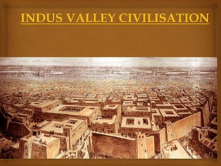
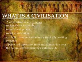
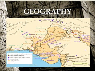
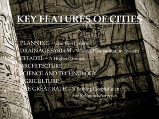
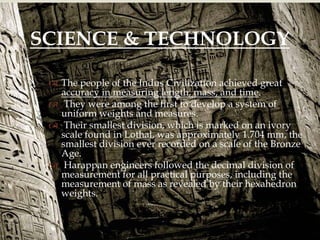
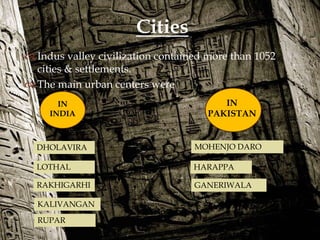
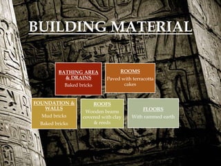
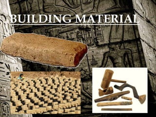
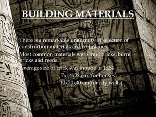
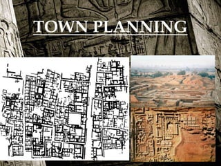
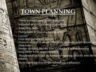
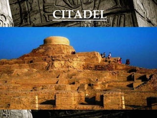
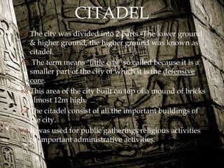
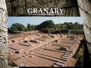
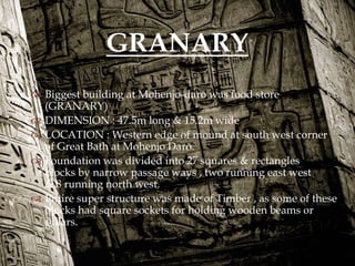
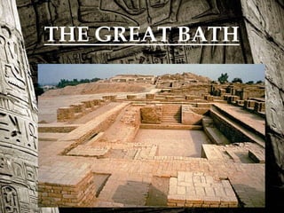
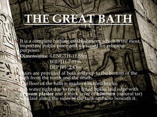
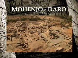
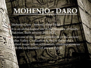
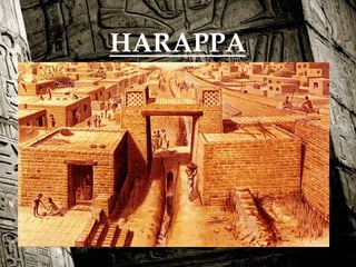

 THIS PRESENTATION IS FOR THE STUDY OF THE
ANCIENT CIVILIZATIONS
PRESENTED BY :-
UMANG MATHUR
KSHITIJA KAPOOR
VISHAL SAINI
VISHAKHA YADAV
AADITYA SHARMA

A civilization is any complex
society characterized by
 urban development,
 social stratification,
 symbolic communication forms (typically, writing
systems)
 a perceived separation from and domination over
the natural environment by a cultural elite
WHAT IS A CIVILISATION

CONTENTS
1. INTRODUCTION & TIME PERIOD
GEOGRAPHY
GEOLOGICAL
CLIMATE
RELIGIOUS
SOCIAL & CULTURE
HISTORICAL
ADMINISTRATION
2. CHARACTERISTIC FEATURES
3. CITY PLANNING
4. TOWN PLANNING
5. BUILDING TYPOLOGY
6. CONSTRUCTION MATERIAL
& CONSTRUCTION TECHNIQUES
7. WATER SUPPLY & DRAINAGE

HOW WAS IVC FOUND?
The discovery of Harappa, and soon
afterwards, Mohenjo-Daro, was the
culmination of work beginning in 1861 with
the founding of the Archaeological Survey of
India in the British Raj.
Excavation of Harappan sites has been
ongoing since 1920, with important
breakthroughs occurring as recently as 1999.
. Until 1999, over 1,056 cities and settlements
had been found, of which 96 have been
excavated, mainly in the general region of the
Indus and Ghaggar-Hakra Rivers and their
tributaries.

AFTER EXCAVATION

INTRODUCTION & TIME PERIOD
 INDUS VALLEY / SINDHU – SARASWATI /
BRONZE AGE CIVILISATION
 Bronze age civilization flourished from 3300BCE-1300BCE.
 Along with Ancient Egypt and Mesopotamia it was one of three early
civilizations of the Old World, and of the three the most widespread.
 It flourished in the basins of the Indus River, one of the major rivers
of Asia, and the Ghaggar-Hakra River, which once coursed through
north- west India and eastern Pakistan.
 This civilization was developed in between THE RIVERS OF
SINDHU & SARASWATI.
 First excavation made in 1920CE near HARAPPA revealed great
urban settlements in Punjab region of present Pakistan.
 Harappa period centered on RAVI RIVER developed from 3300BCE –
2800BCE.
 Mohenjo-daro is a different site located in Sindh region of Pakistan
situated on SINDH RIVER.

They are identified by tool manufacture and use.
Also, these defined the mode of exchange .
ARCHAEOLOGICAL
PERIODS
STONE
AGE:
BRONZE
AGE
IRON
AGE

TIMELINE

GEOGRAPHY
 Spread over an area of some 1,250,000km2
 Encompassed the areas of
Baluchistan
Pakistan
South East Afghanistan
 Extended Indian present states of Rajasthan Gujrat and
Punjab
 These sites were found mostly on river side &
some lie on sea coast.
 Both Mohenjo-daro and Harappa were nearly
a sq. mile area.
GEOGRAPHY

RELIGION
• The main goddess was a mother goddess representing fertility.
• They also worshiped animals.
• On a seal their is a figure sitting in a yoga-like position and is
thought to be an early representation of a Hindu god.
• Some Indus valley seals show swastikas, swastikas were used in
the Hindu Religion. Swastikas were sacred symbol for good
luck. The Hindu religion was probably based off of the Indus
Valley.

KEY FEATURES OF CITIES
 PLANNING – Grid Iron Pattern
 DRAINAGE SYSTEM – World’s First Sanitation System
 CITADEL – A Higher Ground
 ARCHITECTURE
 SCIENCE AND TECHNOLOGY
 AGRICULTURE
 THE GREAT BATH – A Bathing Establishment
For Religious Purposes

 The people of the Indus Civilization achieved great
accuracy in measuring length, mass, and time.
 They were among the first to develop a system of
uniform weights and measures.
 Their smallest division, which is marked on an ivory
scale found in Lothal, was approximately 1.704 mm, the
smallest division ever recorded on a scale of the Bronze
Age.
 Harappan engineers followed the decimal division of
measurement for all practical purposes, including the
measurement of mass as revealed by their hexahedron
weights.
SCIENCE & TECHNOLOGY

 Indus valley civilization contained more than 1052
cities & settlements.
 The main urban centers were
Cities
IN
PAKISTAN
IN
INDIA
DHOLAVIRA
KALIVANGAN
RAKHIGARHI
RUPAR
LOTHAL
MOHENJO DARO
HARAPPA
GANERIWALA

BUILDING MATERIAL
BATHING AREA
& DRAINS
Baked bricks
ROOMS
Paved with terracotta
cakes
FOUNDATION &
WALLS
Mud bricks
Baked bricks
ROOFS
Wooden beams
covered with clay
& reeds
FLOORS
With rammed earth

BUILDING MATERIAL

 There is a remarkable uniformity in selection of
construction materials and techniques.
 Most common materials were mud bricks, burnt
bricks and reeds.
 Average size of brick was in ratio of 1:2:4
7x14x28 cm (for houses)
10x20x40 cm(for city walls)
BUILDING MATERIALS

TOWN PLANNING
 Town were geometrically designed.
 Included several residential quarters.
 Assembly halls
 Public bath & manufacturing unit
 Layout
Grid iron pattern of streets
Narrow streets of about 2.7m wide in north south & east wes
directions
Streets divided the city into 12 blocks. Each measuring 365m
long 244m wide approximately.
 Residential unit had no entrance opening directly into the m
streets.
 No windows towards the subsidiary walkways.
TOWN PLANNING

WATER SUPPLY & DRAINAGE

 High priority was given to hygiene & sanitation.
 This was the world’s first sanitation system.
 Sewerage through underground drains & efficient
water management with numerous reservoirs &
wells were managed.
 Mohenjo-daro had over 700 wells , they were 15m
deep built with TRAPEZOID bricks.
 Each house had a common well for their water usage
& had its own separate bath.
WATER SUPPLY & DRAINAGE

 The entire city was served by extensive system of
drainage
1. The waste water from the houses was connected to
drains running under the walkways.
2. These drains were connected to large sewers laid
under the main street.
3. These small drains were covered by brick slabs.
4.Corbelled brick arches spanned the large main sewers.
5. Man holes were located at regular intervals along
the main sewers for cleaning purpose
6.This elaborate drainage system took care also of the
abundant rainfall in the region.
 DHOLAVIRA town had separate drains to collect
rainwater
* 6 or 7 dams were built across over near by rivers
 It is grouped into three categories with some
variations from rebuilding and modifying.
PRIVATE HOUSES
HOUSING COMPLEX
PUBLIC BUILDINGS
ARCHITECTURAL STYLE

PLANNING OF HOUSES
PRIVATE HOUSES
 The houses of Harappa & Mohenjo-daro were completely
“utilitarian”. Many houses were at least two storey high.
 The houses were planned as a series of rooms around &
open to sky central court.
 The central court ventilates all the room surrounding , it
keeping privacy & security.
 It also provided a space for open air within the house.
 The surroundings rooms are open into this open
courtyards
 No openings were provided on the outside walls except
an entrance door opening into the side lanes.
ARCHITECTURAL STYLE
 The upper storeys were built largely in woods
 The roofs were flat & built of stout beams covered
with planks, finished with the top dressing of beaten
earth.
 Openings were spanned by wooden lintels.

 This includes houses surrounded by smaller units .
 Other units may have been houses of relatives or
service groups.
 Entrances were provided to the premises from the
lanes only.
 Windows were provided at a considerable height
from road/floor level.
 Wooden stairs were incorporated to provide access
to the upper floors.
HOUSING COMPLEX

 These include large public structures that have many
access routs or provide a thorough fare from one
area of the site to another.
 These include markets and places for religious
functions.
PUBLIC BUILDINGS

CITADEL

 The city was divided into 2 parts -The lower ground
& higher ground, the higher ground was known as
citadel.
 The term means "little city" so called because it is a
smaller part of the city of which it is the defensive
core.
 This area of the city built on top of a mound of bricks
almost 12m high.
 The citadel consist of all the important buildings of
the city.
 It was used for public gatherings religious activities
or important administrative activities.
CITADEL

GRANARY

 Biggest building at Mohenjo-daro was food store
(GRANARY)
 DIMENSION : 47.5m long & 15.2m wide
 LOCATION : Western edge of mound at south west corner
of Great Bath at Mohenjo Daro.
 Foundation was divided into 27 squares & rectangles
blocks by narrow passage ways , two running east west
& 8 running north west.
 Entire super structure was made of Timber , as some of these
blocks had square sockets for holding wooden beams or
pillars.
GRANARY

THE GREAT BATH

 It is a complete bathing establishment, which is the most
important public place and was used for religious
purposes.
 Dimensions: LENGTH-11.88m
WIDTH-7.01m
DEPTH- 2.43m
 Stairs are provided at both ends up to the bottom of the
bath from the north and the south.
 The floor of the bath is made of burned bricks.
 It is water tight due to finely fitted bricks laid edge with
gypsum plaster and a thick layer of bitumen (natural tar)
was laid along the sides of the tank and also beneath it.
THE GREAT BATH

MOHENJO - DARO

 Mohenjo-Daro - Mound of the Dead –
 It is an archeological site in the province of Sindh,
Pakistan. Built around 2600 BCE,
 It was one of the largest settlements of the ancient
Indus Valley Civilization & one of the world's
earliest major urban settlements, contemporaneous
with the civilizations of ancient Egypt.
MOHENJO - DARO

HARAPPA
 The site take its name from a modern village located
near the former Ravi river.
 It had a major gateway on its south wall at the center
of a large curve that extends into a large open space.
 At the gateway, the mud brick wall was 9m wide.
 The gate opening was 2.8m wide.
 The city had 23,500 residents.
 Area- 150 hectares.
 Harappa is an archaelogical site in Punjab , Pakistan
HARAPPA

 Food production was largely indigenous to the Indus
Valley. Already the Mehrgarh people used
domesticated wheat and barley and the major
cultivated cereal crop was naked six-row barley, a
crop derived from two-row barley.
 The farmers of Indus Valley grew peas ,sesame and
dates.
AGRICULTURE

 The seals used as an exchange medium and used for
exporting and importing of goods.
 They were found in different civilizations bringing
us proof that these were used for exchange.
HISTORICAL SIGNIFICANCE

ARTS & GAMES
 The people of Indus were great
lovers of fine arts, and
especially dancing ,painting
and sculpture.
 They made sculptures , seals
,pottery ,gold jewellery .
 The major script of the
civilization was the INDUS
SCRIPT
 The reason for decline of such great civilization is not
fully known.
 Probably, the Indus valley civilization declined because of
profound ecological changes produced by its own
expansion & activities
 Destructive flood & changes in course of the river let the
condition of drought in the valley.
 Research also showed that there was extreme level of
radiation exposure in the 44 skeleton found in Harappa.
 Research also proved there was sudden change in
temperature to a very high scale causing sudden decline
of the civilization.
DECLINE
Though there is no legal confirmation of the decline.

Indus valley civilization

  • 1.
      THIS PRESENTATIONIS FOR THE STUDY OF THE ANCIENT CIVILIZATIONS PRESENTED BY :- UMANG MATHUR KSHITIJA KAPOOR VISHAL SAINI VISHAKHA YADAV AADITYA SHARMA
  • 3.
     A civilization isany complex society characterized by  urban development,  social stratification,  symbolic communication forms (typically, writing systems)  a perceived separation from and domination over the natural environment by a cultural elite WHAT IS A CIVILISATION
  • 4.
     CONTENTS 1. INTRODUCTION &TIME PERIOD GEOGRAPHY GEOLOGICAL CLIMATE RELIGIOUS SOCIAL & CULTURE HISTORICAL ADMINISTRATION 2. CHARACTERISTIC FEATURES 3. CITY PLANNING 4. TOWN PLANNING 5. BUILDING TYPOLOGY 6. CONSTRUCTION MATERIAL & CONSTRUCTION TECHNIQUES 7. WATER SUPPLY & DRAINAGE
  • 5.
     HOW WAS IVCFOUND? The discovery of Harappa, and soon afterwards, Mohenjo-Daro, was the culmination of work beginning in 1861 with the founding of the Archaeological Survey of India in the British Raj. Excavation of Harappan sites has been ongoing since 1920, with important breakthroughs occurring as recently as 1999. . Until 1999, over 1,056 cities and settlements had been found, of which 96 have been excavated, mainly in the general region of the Indus and Ghaggar-Hakra Rivers and their tributaries.
  • 6.
  • 7.
     INTRODUCTION & TIMEPERIOD  INDUS VALLEY / SINDHU – SARASWATI / BRONZE AGE CIVILISATION  Bronze age civilization flourished from 3300BCE-1300BCE.  Along with Ancient Egypt and Mesopotamia it was one of three early civilizations of the Old World, and of the three the most widespread.  It flourished in the basins of the Indus River, one of the major rivers of Asia, and the Ghaggar-Hakra River, which once coursed through north- west India and eastern Pakistan.  This civilization was developed in between THE RIVERS OF SINDHU & SARASWATI.  First excavation made in 1920CE near HARAPPA revealed great urban settlements in Punjab region of present Pakistan.  Harappa period centered on RAVI RIVER developed from 3300BCE – 2800BCE.  Mohenjo-daro is a different site located in Sindh region of Pakistan situated on SINDH RIVER.
  • 8.
     They are identifiedby tool manufacture and use. Also, these defined the mode of exchange . ARCHAEOLOGICAL PERIODS STONE AGE: BRONZE AGE IRON AGE
  • 9.
  • 10.
  • 11.
     Spread overan area of some 1,250,000km2  Encompassed the areas of Baluchistan Pakistan South East Afghanistan  Extended Indian present states of Rajasthan Gujrat and Punjab  These sites were found mostly on river side & some lie on sea coast.  Both Mohenjo-daro and Harappa were nearly a sq. mile area. GEOGRAPHY
  • 12.
     RELIGION • The maingoddess was a mother goddess representing fertility. • They also worshiped animals. • On a seal their is a figure sitting in a yoga-like position and is thought to be an early representation of a Hindu god. • Some Indus valley seals show swastikas, swastikas were used in the Hindu Religion. Swastikas were sacred symbol for good luck. The Hindu religion was probably based off of the Indus Valley.
  • 13.
     KEY FEATURES OFCITIES  PLANNING – Grid Iron Pattern  DRAINAGE SYSTEM – World’s First Sanitation System  CITADEL – A Higher Ground  ARCHITECTURE  SCIENCE AND TECHNOLOGY  AGRICULTURE  THE GREAT BATH – A Bathing Establishment For Religious Purposes
  • 14.
      The peopleof the Indus Civilization achieved great accuracy in measuring length, mass, and time.  They were among the first to develop a system of uniform weights and measures.  Their smallest division, which is marked on an ivory scale found in Lothal, was approximately 1.704 mm, the smallest division ever recorded on a scale of the Bronze Age.  Harappan engineers followed the decimal division of measurement for all practical purposes, including the measurement of mass as revealed by their hexahedron weights. SCIENCE & TECHNOLOGY
  • 15.
      Indus valleycivilization contained more than 1052 cities & settlements.  The main urban centers were Cities IN PAKISTAN IN INDIA DHOLAVIRA KALIVANGAN RAKHIGARHI RUPAR LOTHAL MOHENJO DARO HARAPPA GANERIWALA
  • 16.
     BUILDING MATERIAL BATHING AREA &DRAINS Baked bricks ROOMS Paved with terracotta cakes FOUNDATION & WALLS Mud bricks Baked bricks ROOFS Wooden beams covered with clay & reeds FLOORS With rammed earth
  • 17.
  • 18.
      There isa remarkable uniformity in selection of construction materials and techniques.  Most common materials were mud bricks, burnt bricks and reeds.  Average size of brick was in ratio of 1:2:4 7x14x28 cm (for houses) 10x20x40 cm(for city walls) BUILDING MATERIALS
  • 19.
  • 20.
     Town weregeometrically designed.  Included several residential quarters.  Assembly halls  Public bath & manufacturing unit  Layout Grid iron pattern of streets Narrow streets of about 2.7m wide in north south & east wes directions Streets divided the city into 12 blocks. Each measuring 365m long 244m wide approximately.  Residential unit had no entrance opening directly into the m streets.  No windows towards the subsidiary walkways. TOWN PLANNING
  • 21.
  • 22.
      High prioritywas given to hygiene & sanitation.  This was the world’s first sanitation system.  Sewerage through underground drains & efficient water management with numerous reservoirs & wells were managed.  Mohenjo-daro had over 700 wells , they were 15m deep built with TRAPEZOID bricks.  Each house had a common well for their water usage & had its own separate bath. WATER SUPPLY & DRAINAGE
  • 23.
      The entirecity was served by extensive system of drainage 1. The waste water from the houses was connected to drains running under the walkways. 2. These drains were connected to large sewers laid under the main street. 3. These small drains were covered by brick slabs. 4.Corbelled brick arches spanned the large main sewers. 5. Man holes were located at regular intervals along the main sewers for cleaning purpose 6.This elaborate drainage system took care also of the abundant rainfall in the region.  DHOLAVIRA town had separate drains to collect rainwater * 6 or 7 dams were built across over near by rivers
  • 24.
     It isgrouped into three categories with some variations from rebuilding and modifying. PRIVATE HOUSES HOUSING COMPLEX PUBLIC BUILDINGS ARCHITECTURAL STYLE
  • 25.
  • 26.
    PRIVATE HOUSES  Thehouses of Harappa & Mohenjo-daro were completely “utilitarian”. Many houses were at least two storey high.  The houses were planned as a series of rooms around & open to sky central court.  The central court ventilates all the room surrounding , it keeping privacy & security.  It also provided a space for open air within the house.  The surroundings rooms are open into this open courtyards  No openings were provided on the outside walls except an entrance door opening into the side lanes. ARCHITECTURAL STYLE
  • 27.
     The upperstoreys were built largely in woods  The roofs were flat & built of stout beams covered with planks, finished with the top dressing of beaten earth.  Openings were spanned by wooden lintels.
  • 28.
      This includeshouses surrounded by smaller units .  Other units may have been houses of relatives or service groups.  Entrances were provided to the premises from the lanes only.  Windows were provided at a considerable height from road/floor level.  Wooden stairs were incorporated to provide access to the upper floors. HOUSING COMPLEX
  • 29.
      These includelarge public structures that have many access routs or provide a thorough fare from one area of the site to another.  These include markets and places for religious functions. PUBLIC BUILDINGS
  • 30.
  • 31.
      The citywas divided into 2 parts -The lower ground & higher ground, the higher ground was known as citadel.  The term means "little city" so called because it is a smaller part of the city of which it is the defensive core.  This area of the city built on top of a mound of bricks almost 12m high.  The citadel consist of all the important buildings of the city.  It was used for public gatherings religious activities or important administrative activities. CITADEL
  • 32.
  • 33.
      Biggest buildingat Mohenjo-daro was food store (GRANARY)  DIMENSION : 47.5m long & 15.2m wide  LOCATION : Western edge of mound at south west corner of Great Bath at Mohenjo Daro.  Foundation was divided into 27 squares & rectangles blocks by narrow passage ways , two running east west & 8 running north west.  Entire super structure was made of Timber , as some of these blocks had square sockets for holding wooden beams or pillars. GRANARY
  • 34.
  • 35.
      It isa complete bathing establishment, which is the most important public place and was used for religious purposes.  Dimensions: LENGTH-11.88m WIDTH-7.01m DEPTH- 2.43m  Stairs are provided at both ends up to the bottom of the bath from the north and the south.  The floor of the bath is made of burned bricks.  It is water tight due to finely fitted bricks laid edge with gypsum plaster and a thick layer of bitumen (natural tar) was laid along the sides of the tank and also beneath it. THE GREAT BATH
  • 36.
  • 37.
      Mohenjo-Daro -Mound of the Dead –  It is an archeological site in the province of Sindh, Pakistan. Built around 2600 BCE,  It was one of the largest settlements of the ancient Indus Valley Civilization & one of the world's earliest major urban settlements, contemporaneous with the civilizations of ancient Egypt. MOHENJO - DARO
  • 38.
  • 39.
     The sitetake its name from a modern village located near the former Ravi river.  It had a major gateway on its south wall at the center of a large curve that extends into a large open space.  At the gateway, the mud brick wall was 9m wide.  The gate opening was 2.8m wide.  The city had 23,500 residents.  Area- 150 hectares.  Harappa is an archaelogical site in Punjab , Pakistan HARAPPA
  • 40.
      Food productionwas largely indigenous to the Indus Valley. Already the Mehrgarh people used domesticated wheat and barley and the major cultivated cereal crop was naked six-row barley, a crop derived from two-row barley.  The farmers of Indus Valley grew peas ,sesame and dates. AGRICULTURE
  • 41.
      The sealsused as an exchange medium and used for exporting and importing of goods.  They were found in different civilizations bringing us proof that these were used for exchange. HISTORICAL SIGNIFICANCE
  • 42.
     ARTS & GAMES The people of Indus were great lovers of fine arts, and especially dancing ,painting and sculpture.  They made sculptures , seals ,pottery ,gold jewellery .  The major script of the civilization was the INDUS SCRIPT
  • 43.
     The reasonfor decline of such great civilization is not fully known.  Probably, the Indus valley civilization declined because of profound ecological changes produced by its own expansion & activities  Destructive flood & changes in course of the river let the condition of drought in the valley.  Research also showed that there was extreme level of radiation exposure in the 44 skeleton found in Harappa.  Research also proved there was sudden change in temperature to a very high scale causing sudden decline of the civilization. DECLINE Though there is no legal confirmation of the decline.