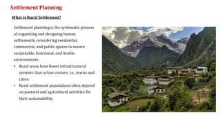
Settlement planning isthe systematic process
of organizing and designing human
settlements, considering residential,
commercial, and public spaces to ensure
sustainable, functional, and livable
environments.
• Rural areas have fewer infrastructural
systems than urban centers, i.e., towns and
cities.
• Rural settlement populations often depend
on pastoral and agricultural activities for
their sustainability.
Settlement Planning
What is Rural Settlement?
• Plateau Villages
•Coastal Villages
• Desert Villages
• Plain Villages
• Forest Villages
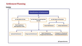
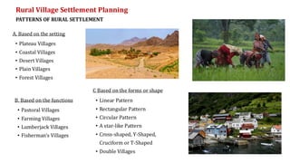
Rural Village Settlement Planning
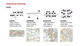
PATTERNS OF RURAL SETTLEMENT
A. Based on the setting
• Pastoral Villages
• Farming Villages
• Lumberjack Villages
• Fisherman’s Villages
B. Based on the functions • Linear Pattern
• Rectangular Pattern
• Circular Pattern
• A star-like Pattern
• Cross-shaped, Y-Shaped,
Cruciform or T-Shaped
• Double Villages
C Based on the forms or shape
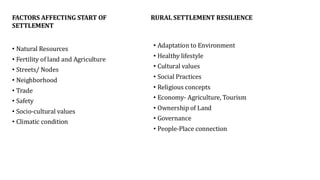
FACTORS AFFECTING STARTOF
SETTLEMENT
• Natural Resources
• Fertility of land and Agriculture
• Streets/ Nodes
• Neighborhood
• Trade
• Safety
• Socio-cultural values
• Climatic condition
RURAL SETTLEMENT RESILIENCE
• Adaptation to Environment
• Healthy lifestyle
• Cultural values
• Social Practices
• Religious concepts
• Economy- Agriculture, Tourism
• Ownership of Land
• Governance
• People-Place connection
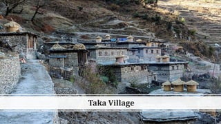
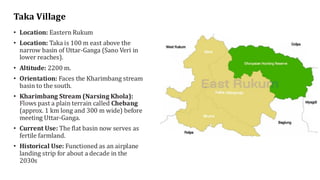
7.
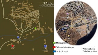
Taka Village
• Location:Eastern Rukum
• Location: Taka is 100 m east above the
narrow basin of Uttar-Ganga (Sano Veri in
lower reaches).
• Altitude: 2200 m.
• Orientation: Faces the Kharimbang stream
basin to the south.
• Kharimbang Stream (Narsing Khola):
Flows past a plain terrain called Chebang
(approx. 1 km long and 300 m wide) before
meeting Uttar-Ganga.
• Current Use: The flat basin now serves as
fertile farmland.
• Historical Use: Functioned as an airplane
landing strip for about a decade in the
2030s
8.
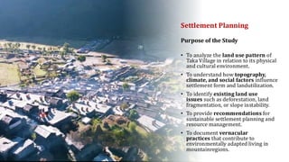
Settlement Planning
• Toanalyze the land use pattern of
Taka Village in relation to its physical
and cultural environment.
• To understand how topography,
climate, and social factors influence
settlement form and landutilization.
• To identify existing land use
issues such as deforestation, land
fragmentation, or slope instability.
• To provide recommendations for
sustainable settlement planning and
resource management.
• To document vernacular
practices that contribute to
environmentally adapted living in
mountainregions.
Purpose of the Study
9.
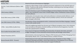
HISTORY
Period / YearHistorical Events & Development Highlights
Ancient / Early Settlement (Before 1800
AD)
Indigenous Kham Magar people establish permanent settlements in the mid-hill region of
Rukum. Traditional agro-pastoral lifestyle develops combining terrace farming, livestock
rearing, and forest resource use.
19th Century (1800s)
Taka area functions as part of traditional Magar territories linked to the historic Takasera
region once considered a local center of Kham Magar culture. Settlements remain isolated
but self-sufficient.
Early 20th Century (1900–1950)
Continuation of vernacular stone-and-mud architecture; minimal outside influence. Local
governance under traditional village councils (mukhiya system). Forest and communal
lands managed collectively.
Late 20th Century (1970s–1980s)
Introduction of basic development works a missionary learns the Kham language . Gradual
contact with outside world.
1990s – Early 2000s (Conflict Era)
Taka and neighboring Upallo Sera become part of Maoist insurgency zones. Area witnesses
social and physical disruption, limited mobility, and infrastructural stagnation. Guerrilla
trails later popularized for trekking.
Post-Conflict Period (2006–2015)
Peace process brings local rebuilding. Reconstruction of schools, foot trails, and small
bridges. Emergence of local awareness toward tourism and heritage conservation.
Federal Transition (2017)
Administrative restructuring Former Takasera VDC becomes part of Putha Uttarganga Rural
Municipality, Wards 10 & 11, East Rukum District, Lumbini Province.
Recent Decade (2018 – Present)
Improvement of rural roads and communication access. Promotion of clean-village
movement (limiting motorbikes, conserving architecture). Development of eco-tourism,
cultural festivals, and wool-craft economy to support livelihoods.
10.
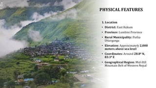
PHYSICAL FEATURES
1. Location
•District: East Rukum
• Province: Lumbini Province
• Rural Municipality: Putha
Uttarganga
• Elevation: Approximately 2,000
meters above sea level
• Coordinates: Around 28.8° N,
83.3° E
• Geographical Region: Mid-Hill
Mountain Belt of Western Nepal
11.
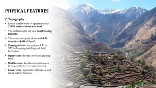
PHYSICAL FEATURES
2. Topography
•Lies at an elevation of approximately
2,000 meters above sea level.
• The settlement is set on a south-facing
hillside.
• The area forms part of the mid-hill
mountain belt of Nepal.
• Slope gradient: Varies from 15° to
35°, influencing building and field
formation.
• Upper zone: Forest cover and grazing
land.
• Middle zone: Residential settlement
(compact clusters along contours).
• Lower zone: Agricultural terraces and
small water channels.
12.
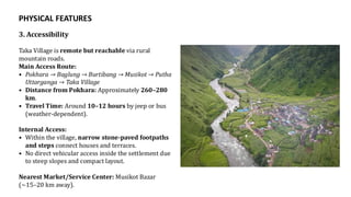
PHYSICAL FEATURES
3. Accessibility
TakaVillage is remote but reachable via rural
mountain roads.
Main Access Route:
• Pokhara → Baglung → Burtibang → Musikot → Putha
Uttarganga → Taka Village
• Distance from Pokhara: Approximately 260–280
km.
• Travel Time: Around 10–12 hours by jeep or bus
(weather-dependent).
Internal Access:
• Within the village, narrow stone-paved footpaths
and steps connect houses and terraces.
• No direct vehicular access inside the settlement due
to steep slopes and compact layout.
Nearest Market/Service Center: Musikot Bazar
(~15–20 km away).
13.
PHYSICAL FEATURES
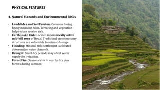
4. NaturalHazards and Environmental Risks
• Landslides and Soil Erosion: Common during
heavy monsoon rains. Terracing and vegetation
help reduce erosion risk.
• Earthquake Risk: Located in seismically active
mid-hill zone of Nepal. Traditional stone masonry
structures are vulnerable to seismic damage.
• Flooding: Minimal risk; settlement is elevated
above major water channels.
• Drought: Short dry periods may affect water
supply for irrigation.
• Forest Fire: Seasonal risk in nearby dry pine
forests during summer.
14.
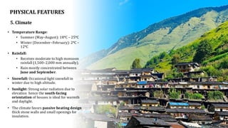
5. Climate
• TemperatureRange:
• Summer (May–August): 18°C – 25°C
• Winter (December–February): 2°C –
12°C
• Rainfall:
• Receives moderate to high monsoon
rainfall (1,500–2,000 mm annually).
• Rain mostly concentrated between
June and September.
• Snowfall: Occasional light snowfall in
winter due to high altitude.
• Sunlight: Strong solar radiation due to
elevation hence the south-facing
orientation of houses is ideal for warmth
and daylight.
• The climate favors passive heating design
thick stone walls and small openings for
insulation.
PHYSICAL FEATURES
15.
SOCIO- ECONOMIC FEATURES
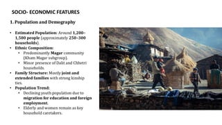
1.Population and Demography
• Estimated Population: Around 1,200–
1,500 people (approximately 250–300
households).
• Ethnic Composition:
• Predominantly Magar community
(Kham Magar subgroup).
• Minor presence of Dalit and Chhetri
households.
• Family Structure: Mostly joint and
extended families with strong kinship
ties.
• Population Trend:
• Declining youth population due to
migration for education and foreign
employment.
• Elderly and women remain as key
household caretakers.
16.
SOCIO- ECONOMIC FEATURES
1.Population and Demography
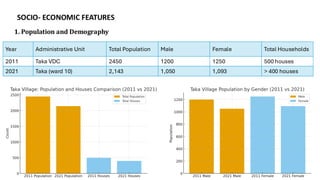
Year Administrative Unit Total Population Male Female Total Households
2011 Taka VDC 2450 1200 1250 500 houses
2021 Taka (ward 10) 2,143 1,050 1,093 > 400 houses
17.
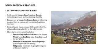
• Settlement isterraced and contour-based,
minimizing erosion and maximizing stability.
• Houses are arranged in linear clusters following
contour lines to reduce soil erosion and optimize
land use.
• Footpaths and stairs connect different levels of the
village, adapting naturally to the hilly terrain.
• The natural environment includes:
• Terraced agricultural fields on the slopes.
• Mixed broadleaf and pine forests around
the periphery.
• Seasonal streams and natural springs
providing local water supply.
• Ridges and contours shaping the organic
settlement pattern.
2. SETTLEMENT AND GEOGRAPHY
SOCIO- ECONOMIC FEATURES
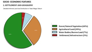
18.
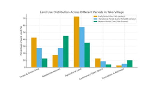
• Forest/Natural Vegetation(60%)
• Agricultural Land (30%),
• Water Bodies/Barren Land (7%)
• Settlement/Infrastructure (3%)
2. SETTLEMENT AND GEOGRAPHY
SOCIO- ECONOMIC FEATURES
19.
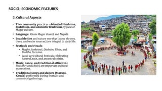
3. Cultural Aspects
•The community practices a blend of Hinduism,
Buddhism, and animistic traditions, typical of
Magar culture.
• Language: Kham Magar dialect and Nepali.
• Local deities and nature worship (stone shrines,
trees, and water sources) are integral to daily life.
• Festivals and rituals:
• Maghe Sankranti, Dashain, Tihar, and
Buddha Purnima.
• Local agricultural festivals celebrating
harvest, rain, and ancestral spirits.
• Music, dance, and traditional attire (like
bhakkhri and cholo) are important cultural
expressions.
• Traditional songs and dances (Maruni,
Kauda) performed during festivals and
communal gatherings.
SOCIO- ECONOMIC FEATURES
20.
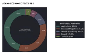
SOCIO- ECONOMIC FEATURES
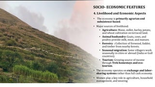
•The economy is primarily agrarian and
subsistence-based.
• Major sources of livelihood:
• Agriculture: Maize, millet, barley, potato,
and wheat cultivation on terraced land.
• Animal husbandry: Goats, cows, and
poultry provide milk, meat, and manure.
• Forestry : Collection of firewood, fodder,
and timber from nearby forests.
• Seasonal migration: Some villagers work
seasonally in cities or abroad (India or Gulf
countries).
• Tourism: Growing source of income
through Trek homestays and eco-
tourism.
• The economy operates on exchange and labor-
sharing systems rather than full cash economy.
• Women play a key role in agriculture, household
management, and weaving
4. Livelihood and Economic Aspects
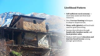
Livelihood Pattern
• Self-sufficientrural economy —
most daily needs met from local
resources.
• Use of terrace farming techniques
to adapt to sloped terrain.
• Water mills (ghatta) and local tools
used for grain processing.
• Income diversification through
handicrafts, bamboo works, and
local produce sales.
• Gradual shift toward education and
tourism-based income among
younger generations.
23.
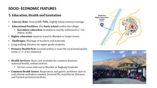
5. Education, Healthand Sanitation
• Literacy Rate: Around 65–70%, slightly below national average.
• Educational Facilities: One basic school within the village.
• Secondary education available in nearby settlements (~10–
30min. walk).
• Higher education requires travel to Musikot or larger towns.
• Challenges: Shortage of teachers and materials.
• Long walking distance for upper-grade students.
• Primary Health Post: Located within or near the rural municipality
center (~1–2 hrs distance).
• Health Services: Basic care available for common diseases,
maternal health, andvaccination.
• Serious cases referred to Musikot or Baglung hospitals.
• Common Health Issues: Respiratory and gastric problems (due to
cold climate andindoor smoke), Seasonal flu, waterborne diseases,
and limited sanitation facilities.
SOCIO- ECONOMIC FEATURES
24.
INFRASTRUCTURE ASPECTS OF
TAKAVILLAGE
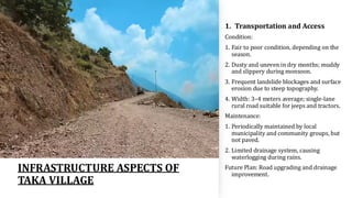
1. Transportation and Access
Condition:
1. Fair to poor condition, depending on the
season.
2. Dusty and uneven in dry months; muddy
and slippery during monsoon.
3. Frequent landslide blockages and surface
erosion due to steep topography.
4. Width: 3–4 meters average; single-lane
rural road suitable for jeeps and tractors.
Maintenance:
1. Periodically maintained by local
municipality and community groups, but
not paved.
2. Limited drainage system, causing
waterlogging during rains.
Future Plan: Road upgrading and drainage
improvement.
25.
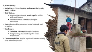
2. Water Supply
•Main Source: Natural spring andstream-fed gravity
water system.
• Distribution:
• Community-managed publictaps located in
differentclusters.
• Water collection tanks built athigher
elevations.
• Usage: For drinking, domesticchores, livestock, and
irrigation.
• Challenges:
• Seasonal shortage duringdry months.
• Long walking distance to tapsfor some
households.
• Community Effort: Regular repairand maintenance by
local wateruser groups.
26.
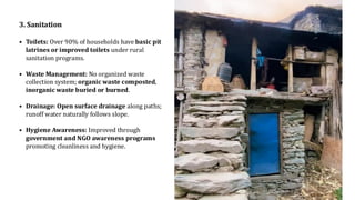
3. Sanitation
• Toilets:Over 90% of households have basic pit
latrines or improved toilets under rural
sanitation programs.
• Waste Management: No organized waste
collection system; organic waste composted,
inorganic waste buried or burned.
• Drainage: Open surface drainage along paths;
runoff water naturally follows slope.
• Hygiene Awareness: Improved through
government and NGO awareness programs
promoting cleanliness and hygiene.
27.
4. Electricity andEnergy
Power Source:
• Connected to national grid through rural
electrification program.
• Some households use solar panels as backup.
Reliability: Generally available, but low voltage and
frequent outages during rain or winter.
Alternative Energy: Firewood, biogas
5. Communication and Technology
• Mobile Network: Coverage by NTC and Ncell, though
signal fluctuates in hilly terrain.
• Internet Access: Limited; some households
use mobile data or community Wi-Fi hotspotat
school or ward office.
• Postal Services: Handled through municipality
office or nearby market center.
• Digital Literacy: Growing among youth due to
smartphone use and education.
28.
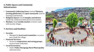
6. Public Spacesand Community
Infrastructure
• Community Gathering Areas: Central Chautara
(resting platforms) and open courtyards used for
meetings and festivals.
• Religious Spaces: Small temples and shrines
within the settlement dedicated to local deities.
• Markets: Small weekly market or barter trade
with nearby villages.
7. Services and Facilities
• Security:
• Managed by local ward committee; no police
post inside the village.
• Financial Services:
• Access to cooperatives and saving groups;
nearest bank in Musikot.
• Local Governance:
• Under Putha Uttarganga Rural Municipality
administration
29.
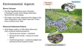
Environmental Aspects
Compact housesin highland
Plain fertile
lowlands
Narsing Khola
Rivers/ Streams
• The Narsing Khola flows past a flat plain
(“Chebang”) south of the village which later
descends into uttar ganga.
• The larger river basin adjacent to the village is the
Uttar Ganga River (also called “Sano Veri” in the
lower reaches) near Taka.
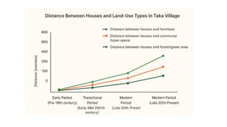
Historical Settlement Pattern
• Early Magar settlers in Taka likely followed a
river-oriented settlement pattern:
• Flat basin near stream → farmland
• Elevated site nearby → houses to avoid
floods
• South-facing slopes → optimal sunlight and
protection from northern winds
30.
Significance of river/stream
Irrigation & Fertile Land
• The stream creates a flat plain (Chebang) used for farming.
• Provides water for crops and keeps the soil fertile.
Settlement Location & Orientation
• Village built above flood level for safety.
• Houses face south toward the stream basin for sunlight and warmth.
Water for Daily Life & Livelihood
• Stream supplies water for home use and irrigation.
• Powered traditional water mills in the past.
Long-Term Influence
• Stream shaped how houses and fields were arranged.
• Guided cultural practices and adaptation to the environment.
31.
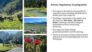
Forest/ Vegetation/ Grazinglands
• The region is described as having diverse
vegetation types including rhododendron,
deodar, pine, oak, maple etc.
• The Magar community in the region view
the forest as “Our store… the cave is
home”, showing a cultural-ecological
attachment to forest and grazing
territories.
• The region has high-altitude
grasslands/pastures used for grazing.
• The local economy includes medicinal herb
collection from forested highlands in Putha
Uttarganga.
32.
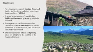
Significance
• Forest resourcessupply timber, firewood,
fodder for livestock, and other non-timber
forest products (NTFPs)
• Grazing lands (pastures) provide key
fodder and summer grazing grounds for
livestock
• The vegetation and forest cover also
contribute to erosion control, catchment
protection of water sources, and the micro-
climate for settlement.
• The cultural value: forests and grazing
lands are integral to the identity of the
Magar settlement
33.
Environmental Aspects
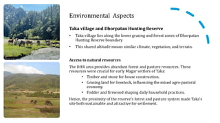
Taka villageand Dhorpatan Hunting Reserve
• Taka village lies along the lower grazing and forest zones of Dhorpatan
Hunting Reserve boundary
• This shared altitude means similar climate, vegetation, and terrain.
Access to natural resources
The DHR area provides abundant forest and pasture resources. These
resources were crucial for early Magar settlers of Taka:
• Timber and stone for house construction.
• Grazing land for livestock, influencing the mixed agro-pastoral
economy.
• Fodder and firewood shaping daily household practices.
Hence, the proximity of the reserve’s forest and pasture system made Taka’s
site both sustainable and attractive for settlement.
34.
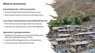
Increasing density /built-up expansion
• Dense housing reduces farmland & green space
• More surface runoff, soil erosion & drainage issues
Loss of open communal space and traditional land-use
• Flat roofs & courtyards replaced by taller houses
• Less space for drying crops, social use & vegetation
Agricultural / grazing transitions
• Settlement expansion and increased building stock,
agriculture/grazing land may shrink
• Leads to habitat fragmentation, soil degradation
• Increased runoff, reduced biodiversity.
Effects on Environment
35.
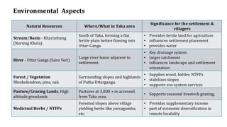
Natural Resources Where/Whatin Taka area
Significance for the settlement &
villagers
Stream/Basin - Kharimbang
(Narsing Khola)
South of Taka, forming a flat
fertile plain before flowing into
Uttar-Ganga.
• Provides fertile land for agriculture
• influences settlement placement
• provides water
River - Uttar Ganga (Sano Veri)
Large river basin adjacent to
settlement.
• Key drainage system
• larger catchment
• influences landscape and settlement
orientation
Forest / Vegetation
Rhododendron, pine, oak
Surrounding slopes and highlands
of Putha Uttarganga.
• Supplies wood, fodder, NTFPs
• stabilizes slopes
• supports eco-system services
Pasture/Grazing Lands, High
altitude grasslands
Pastures at 3,000 + m accessed
from Taka area.
• Supports seasonal livestock grazing,
Medicinal Herbs / NTFPs
Forested slopes above village
yielding herbs like yarsagumba,
etc.
• Provides supplementary income
• part of economic diversification in
remote localality
Environmental Aspects
36.
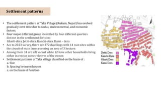
Settlement patterns
• Thesettlement pattern of Taka Village (Rukum, Nepal) has evolved
gradually over time due to social, environmental, and economic
factors.
• Four major different group identified by four different quarters
distinct in the settlement division:
Gharti-dera, Jethi-dera, Kanchi-dera, Kami – dera
• Acc to 2023 survey, there are 372 dwellings with 14 ruin sites within
the circuit of main lanes covering an area of 3 hectare.
• Among them 34 are left vacant while 12 have other households living
either in rent or some relatives of the owner.
• Settlement patterns of Taka village classified on the basis of :
a. Size
b. Spacing between houses
c. on the basis of function
37.
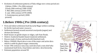
• Evolution ofsettlement patterns of Taka village over a time period are:
1.Before 1900s ( Pre 20th century)
2.Early 20th century( 1900-1930)
3. Mid 20th century (1930-1970)
4. Late 20th century (1970-2000)
5. Contemporary period ( 2000-
present)
• First and oldest settlement built by early Magar settlers seeking
for fertile land and water resource.
• Settlement formed around ancestral courtyards (aagan) and
shrines (kul deuta).
• Built houses on gentle slopes or ridges, safe from floods.
• Pattern: Scattered hamlet-based clustered settlement.
• Houses made of stone and mud with thatched roofs
• Before 1900AD, Gharti dera is one of the major and active dera
which is settle by gharti magar community.
• In late 19th century ( rana era), each dera had a own chief who
maintained built form, ritual duties and intra- dera hierarchy.
• Estimate population around 50
1.Before 1900s ( Pre 20th century)
38.
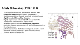
2.Early 20th century(1900-1930)
• As the population increased within Gharti Dera, the first
expansion cluster formed — known as Jethi Dera.
• Families that split from the main household built their homes
slightly apart within walking distance.
• Slightly larger houses with courtyards and open fronts.
• Formed along contour lines for slope stability.
• Settlement pattern remained semi-compact extension ,
continuing the same architectural style and building materials as
the original cluster.
• Jethi Dera symbolizes the first outward growth from the parent
settlement, showing the village’s generational expansion
• Estimate population around 80.
39.
3. Mid 20thcentury (1930-1970)
• With further division of families and increasing population, a new cluster
called Kanchi Dera (“Kanchi” meaning younger branch) emerged.
• Located further away from the original core, it expansion towards
peripheral zones of the village.
• The settlement form became more dispersed compared to Gharti and Jethi
Deras
• Influenced by availability of land and access to trails.
• It represents the third phase of growth — new generations seeking independence but
maintaining social connection to the main village.
• Houses with larger courtyards and open verandahs.
• Small changes in house layout.
• Decline of dera chiefs as centralized state institutions and administrative reforms spread.
• Estimate population around 120.
40.
4. Late 20thcentury (1970-2000)
• Emergence of Kami Dera as a separate caste-based cluster, inhabited by the Kami
• Because of social hierarchy and caste-based , Kami Dera was formed slightly
detached from the main Magar dera.
• Specialized in making metal tool,agricultural tools and household items.
• Began small trade and exchange activities.
• The houses were smaller and simpler, but functionally located near pathways or
agricultural zones to support their occupational needs.
• Smaller one-story houses with mud plaster and tin roofs.
• Functional layouts with open workspaces for toolmaking
• caste occupation influenced spatial organization within the village
• Introduction of rural roads and electricity influenced some families to move closer to
accessible routes
• Migration (temporary or permanent) to cities or abroad led to vacant traditional
houses in older hamlets.
41.
5) Contemporary period( 2000- present)
• The settlement now shows a combination of clustered
traditional cores and scattered modern dwellings.
• All deras now connected by roads, schools, and shared facilities.
• education reduced caste segregation.
• Houses made of brick, cement
• Some families migrated; others rebuilt modern homes
• Landscape changing from purely agricultural to mixed-use
(residential + small business)
• Retention of old cultural nodes (temples, chautaras).
• Interest in Kham/Magar culture and trekking routes created modest
tourism flows; this encourages preservation of traditional cores
while peripheral areas modernize.
42.
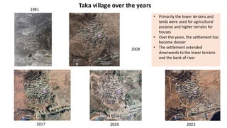
Taka village overthe years
2023
2020
2017
2008
1981
• Primarily the lower terrains and
lands were used for agricultural
purpose and higher terrains for
houses
• Over the years, the settlement has
become denser
• The settlement extended
downwards to the lower terrains
and the bank of river
43.
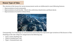
The selection ofthe houses for survey measurement works are deliberated to meet following features:
• Representation of each community.
• Representation of each locality : Gharti-dera, Jethi-dera, Kanchi-dera and Kami-deraii.
• Representation of variation in house form.
Consequently, 2 to 4 dwellings are selected from each locality that represents type variations of the houses in Taka
Dwellings of the taka village are categorized in the following way:
• Type A- Basic dwelling unit
• Type B- Doubled basic unit
• Type C- Extended basic unit
House Type of Taka
44.
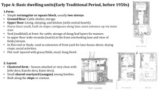
Type A: Basicdwelling units(Early Traditional Period, before 1950s)
1.Form:
• Simple rectangular or square block, usually two storeys.
• Ground floor: Cattle shelter, storage.
• Upper floor: Living, sleeping, and kitchen (with central hearth).
• House faces south, built on slope; contiguous along lane; main entrance up via stone
stair.
• Yard (malkhād) at front: for cattle, storage of dung/leaf layers for manure.
• In upper floor wide veranda (mairā) at the front overlooking lane and view of
fields/stream.
• In Flat roof or thada used as extension of front yard for lane-house above; drying
crops; social activities.
• Flat roof: layered with grass/thŭki, mud/ dung finish; water drains toward front
2. Layout:
• Clustered form – houses attached or very close within same dera (Gharti-dera,
Jethi-dera, Kanchi-dera, Kami-dera).
• Small shared courtyard (aangan) among families.
• Built along the slope or contour.
45.
3.Material:
• Stone masonrywith mud mortar.
• Timber beams and rafters, thatch or slate roof.
• local woods (khasru, salla, dhupi) used.
4.Architectural Features:
• Thick walls for insulation.60 cm ground floor, ~ 40 cm upper floor.
• Small openings for light and ventilation.
• Organic form, responding to terrain.
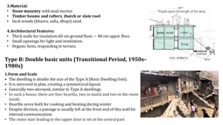
Type B: Double basic units (Transitional Period, 1950s–
1980s)
1.Form and Scale
• The dwelling is double the size of the Type A (Basic Dwelling Unit).
• It is mirrored in plan, creating a symmetrical layout.
• Generally two-storeyed, similar to Type A dwellings.
• In such a house, there are four hearths, two in mairā and two in the room
inside.
• Hearths serve both for cooking and heating during winter
• Despite division, a passage is usually left at the front end of this wall for
internal communication.
• The stone stair leading to the upper door is set at the central part.
46.
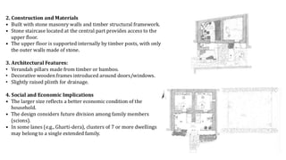
2. Construction andMaterials
• Built with stone masonry walls and timber structural framework.
• Stone staircase located at the central part provides access to the
upper floor.
• The upper floor is supported internally by timber posts, with only
the outer walls made of stone.
3. Architectural Features:
• Verandah pillars made from timber or bamboo.
• Decorative wooden frames introduced around doors/windows.
• Slightly raised plinth for drainage.
4. Social and Economic Implications
• The larger size reflects a better economic condition of the
household.
• The design considers future division among family members
(scions).
• In some lanes (e.g., Gharti-dera), clusters of 7 or more dwellings
may belong to a single extended family.
47.
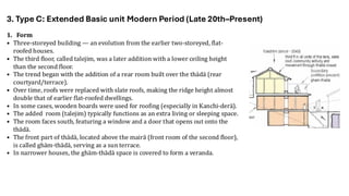
1. Form
• Three-storeyedbuilding — an evolution from the earlier two-storeyed, flat-
roofed houses.
• The third floor, called talejim, was a later addition with a lower ceiling height
than the second floor.
• The trend began with the addition of a rear room built over the thādā (rear
courtyard/terrace).
• Over time, roofs were replaced with slate roofs, making the ridge height almost
double that of earlier flat-roofed dwellings.
• In some cases, wooden boards were used for roofing (especially in Kanchi-derā).
• The added room (talejim) typically functions as an extra living or sleeping space.
• The room faces south, featuring a window and a door that opens out onto the
thādā.
• The front part of thādā, located above the mairā (front room of the second floor),
is called ghām-thādā, serving as a sun terrace.
• In narrower houses, the ghām-thādā space is covered to form a veranda.
3. Type C: Extended Basic unit Modern Period (Late 20th–Present)
48.
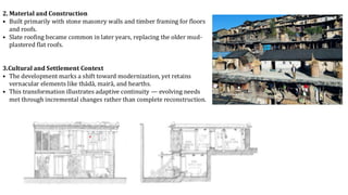
2. Material andConstruction
• Built primarily with stone masonry walls and timber framing for floors
and roofs.
• Slate roofing became common in later years, replacing the older mud-
plastered flat roofs.
3.Cultural and Settlement Context
• The development marks a shift toward modernization, yet retains
vernacular elements like thādā, mairā, and hearths.
• This transformation illustrates adaptive continuity — evolving needs
met through incremental changes rather than complete reconstruction.
49.
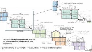
Fig: Relationship ofDwelling floor levels, Thada roof level and terrain profile
The overall village image evolved from low,
flat forms to vertical compositions with
sloped roofs.
50.
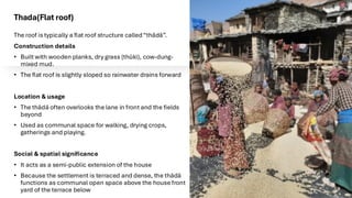
Thada(Flat roof)
The roofis typically a flat roof structure called“thādā”.
Construction details
• Built with wooden planks, dry grass (thŭki), cow-dung-
mixed mud.
• The flat roof is slightly sloped so rainwater drains forward
Location & usage
• The thādā often overlooks the lane in front and the fields
beyond
• Used as communal space for walking, drying crops,
gatherings and playing.
Social & spatial significance
• It acts as a semi-public extension of the house
• Because the settlement is terraced and dense, the thādā
functions as communal open space above the house front
yard of the terrace below
51.
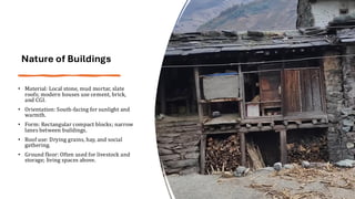
Nature of Buildings
•Material: Local stone, mud mortar, slate
roofs; modern houses use cement, brick,
and CGI.
• Orientation: South-facing for sunlight and
warmth.
• Form: Rectangular compact blocks; narrow
lanes between buildings.
• Roof use: Drying grains, hay, and social
gathering.
• Ground floor: Often used for livestock and
storage; living spaces above.
52.
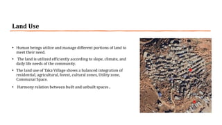
Land Use
• Humanbeings utilize and manage different portions of land to
meet their need.
• The land is utilized efficiently according to slope, climate, and
daily life needs of the community.
• The land use of Taka Village shows a balanced integration of
residential, agricultural, forest, cultural zones, Utility zone,
Communal Space.
• Harmony relation between built and unbuilt spaces .
55.
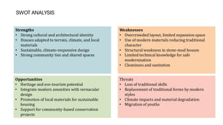
SWOT ANALYSIS
Strengths
• Strongcultural and architectural identity
• Houses adapted to terrain, climate, and local
materials
• Sustainable, climate-responsive design
• Strong community ties and shared spaces
Weaknesses
• Overcrowded layout, limited expansion space
• Use of modern materials reducing traditional
character
• Structural weakness in stone-mud houses
• Limited technical knowledge for safe
modernization
• Cleaniness and sanitation
Opportunities
• Heritage and eco-tourism potential
• Integrate modern amenities with vernacular
design
• Promotion of local materials for sustainable
housing
• Support for community-based conservation
projects
Threats
• Loss of traditional skills
• Replacement of traditional forms by modern
styles
• Climate impacts and material degradation
• Migration of youths