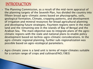
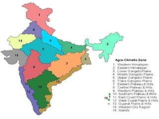
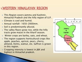
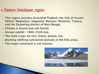
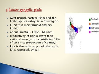
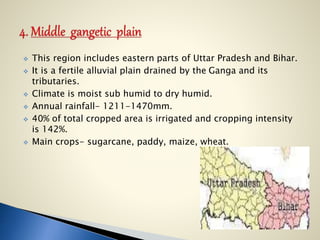
The document discusses India's 15 agro-climatic zones which were delineated based on physiography, soils, climate, cropping patterns, and development of irrigation and mineral resources. It provides details on the characteristics of each zone such as annual rainfall, major crops grown, irrigation sources, and challenges and recommendations. The zones vary from humid alpine to arid desert conditions. Understanding the zones can help scientific management of regional resources to meet food, fibre, fodder and fuel wood needs sustainably. Local populations can benefit from knowledge of their zone's characteristics and related programs to diversify and stabilize incomes.
This ppt is about the distribution of wasteland and problem soils. Those lands are wastelands which are ecologically unstable,
whose topsoil has nearly been completely lost, and
which have developed toxicity in the root zones or growth of most plants, both annual crops and trees”.
GIS and Remote Sensing in Diagnosis and Management of Problem Soil with audio...KaminiKumari13
GIS and Remote Sensing in Diagnosis and Management of Problem Soil for agriculture, soil science, agronomy, forestry, land management and planning with audio by Dr. Kamini Roy
Wastelands refer to degraded lands that are currently underutilized, and are deteriorating for lack of appropriate soil & water management or on account of natural causes.
Wastelands develop naturally or due to influence of environment, chemical and physical properties of the soil or management constraints.
The classification scheme adopted for monitoring of wasteland on 1:50,000 scale.
On the other hand, the Wasteland Development Board and some other institutions have considered all those categories of land as wastelands which are not under the use of forest pasture and cultivation.
From the utilization point of view, wastelands are classified as forest wasteland and non-forest wasteland, cultivated wasteland and non-cultivated wasteland .
In the wasteland classification scheme followed by Department of Land Resources, Ministry of Rural Development and National Remote Sensing Centre, Indian Space Research Organization, Department of Space, Govt. of India during 2003 for Wastelands Atlas of India 2005, 28 categories of wastelands were identified which have been now brought down to 23 categories in the wasteland classification scheme followed in 2006 for the preparation of Wastelands Atlas of India 2010.
Following thirteen categories of lands were classified under wastelands in India.
Gullied and/or ravenous land
Upland with or without scrub.
Water logged and marshy land.
Land affected by salinity/alkalinity-coastal /inland.
Shifting cultivation area.
Underutilized /degraded notified forest land.
Degraded pastures/grazing land.
Sands-deserted/coastal
Mining-industrial wastelands.
Barren rocky/stony waste/ sheet rocky area.
Steep sloping areas.
Snow covered land/or glacial area.
Degraded land under plantation crops
Sub: Rainfed Agriculture and Watershed Management.
Topic: Drought: types, effect of water deficit on physio-morphological characteristics of the plants, Crop adaptation and mitigation to drought
The Contingency plans cover contingency strategies to be taken up by farmers in response to major weather related aberrations such as delay in onset and breaks in monsoon causing early, mid and late season droughts, floods, unusual rains, extreme weather events such as heat wave, cold wave, frost, hailstorm and cyclone.
Agroclimatic zones of jharkhand, rainfall patterns and abiotic stressesVIJAYKUMARSHRIVASTAV2
Jharkhand, agro-climatic zones, rainfall patterns, abiotic stresses, food security index, central north plateau zones, western plateau zones, south eastern plateau zones
Agriculture Issues in Bhaderwah of Doda Districtijtsrd
Since ancient times, agriculture has been one of the most significant economic activity in both the nation and the state of Jammu and Kashmir. It merely refers to the growing of crops. It is also regarded as the foundation of the economy. The majority of the population in the state is directly or indirectly dependent on agriculture, making it an agricultural state. It accounts for almost 60 of state revenue, which adequately explains the states excessive reliance on agriculture. Just 5 of the states land area is suitable for cultivation, and over 92 of it is made up of steep mountains. Forests cover more than 27 of the states total land area. 5.16 of the area is made up of permanent pastures, 14 is used for other purposes besides agriculture, and a little more than 9 is desert. The state has been designated as an apple and walnut export zone for agriculture. One of the areas in the state that is centred on agriculture is Bhaderwah. Bhaderwah differs from the rest of the state due to its distinct geographic features in comparison to other areas. Bhaderwah is a town, tehsil, subdistrict, and extra district in the Doda district of the Jammu Region of Jammu and Kashmir, India. It is also known as Bhaderwah Valley. Due to its picturesque surroundings and high literacy rate, it is also renowned as Chota Kashmir Little Kashmir and is referred to as the Kerala of Jammu and Kashmir. The topography is irregular, and the landscape is exceedingly rough and mountainous. The region is also known as the country of towering mountains, little valleys, and meadows, all of which exhibit significant elevational variation. There is little room for farming due to the proximity of the Pir Panjal and Lesser Himalaya ranges, which are connected by a large number of tiny forested hills. This area is terraced because of its sloping topography. The Bhaderwah has a mountainous, forested topography, and during the winter, the majority of its sections are covered with snow. The solitary stream that flows into the Chenab River and drains the Bhaderwah valley is the Neeru. Despite all of these challenges, agriculture is still practised and is an important topic of conversation. Mr. Taseer Ahmed | Mr. Anoop Singh | Mr. Pankaj Verma "Agriculture Issues in Bhaderwah of Doda District" Published in International Journal of Trend in Scientific Research and Development (ijtsrd), ISSN: 2456-6470, Volume-7 | Issue-2 , April 2023, URL: https://www.ijtsrd.com.com/papers/ijtsrd53889.pdf Paper URL: https://www.ijtsrd.com.com/humanities-and-the-arts/geography/53889/agriculture-issues-in-bhaderwah-of-doda-district/mr-taseer-ahmed
land resources of india+land utilisation.pptxLavVicky
it is about land resources and land utilisation pattern in india with the recent data on the same.classification of land resources and explanation for the different land types.
The Roman Empire A Historical Colossus.pdfkaushalkr1407
The Roman Empire, a vast and enduring power, stands as one of history's most remarkable civilizations, leaving an indelible imprint on the world. It emerged from the Roman Republic, transitioning into an imperial powerhouse under the leadership of Augustus Caesar in 27 BCE. This transformation marked the beginning of an era defined by unprecedented territorial expansion, architectural marvels, and profound cultural influence.
The empire's roots lie in the city of Rome, founded, according to legend, by Romulus in 753 BCE. Over centuries, Rome evolved from a small settlement to a formidable republic, characterized by a complex political system with elected officials and checks on power. However, internal strife, class conflicts, and military ambitions paved the way for the end of the Republic. Julius Caesar’s dictatorship and subsequent assassination in 44 BCE created a power vacuum, leading to a civil war. Octavian, later Augustus, emerged victorious, heralding the Roman Empire’s birth.
Under Augustus, the empire experienced the Pax Romana, a 200-year period of relative peace and stability. Augustus reformed the military, established efficient administrative systems, and initiated grand construction projects. The empire's borders expanded, encompassing territories from Britain to Egypt and from Spain to the Euphrates. Roman legions, renowned for their discipline and engineering prowess, secured and maintained these vast territories, building roads, fortifications, and cities that facilitated control and integration.
The Roman Empire’s society was hierarchical, with a rigid class system. At the top were the patricians, wealthy elites who held significant political power. Below them were the plebeians, free citizens with limited political influence, and the vast numbers of slaves who formed the backbone of the economy. The family unit was central, governed by the paterfamilias, the male head who held absolute authority.
Culturally, the Romans were eclectic, absorbing and adapting elements from the civilizations they encountered, particularly the Greeks. Roman art, literature, and philosophy reflected this synthesis, creating a rich cultural tapestry. Latin, the Roman language, became the lingua franca of the Western world, influencing numerous modern languages.
Roman architecture and engineering achievements were monumental. They perfected the arch, vault, and dome, constructing enduring structures like the Colosseum, Pantheon, and aqueducts. These engineering marvels not only showcased Roman ingenuity but also served practical purposes, from public entertainment to water supply.
Welcome to TechSoup New Member Orientation and Q&A (May 2024).pdfTechSoup
In this webinar you will learn how your organization can access TechSoup's wide variety of product discount and donation programs. From hardware to software, we'll give you a tour of the tools available to help your nonprofit with productivity, collaboration, financial management, donor tracking, security, and more.
Biological screening of herbal drugs: Introduction and Need for
Phyto-Pharmacological Screening, New Strategies for evaluating
Natural Products, In vitro evaluation techniques for Antioxidants, Antimicrobial and Anticancer drugs. In vivo evaluation techniques
for Anti-inflammatory, Antiulcer, Anticancer, Wound healing, Antidiabetic, Hepatoprotective, Cardio protective, Diuretics and
Antifertility, Toxicity studies as per OECD guidelines
Unit 8 - Information and Communication Technology (Paper I).pdfThiyagu K
This slides describes the basic concepts of ICT, basics of Email, Emerging Technology and Digital Initiatives in Education. This presentations aligns with the UGC Paper I syllabus.
Instructions for Submissions thorugh G- Classroom.pptxJheel Barad
This presentation provides a briefing on how to upload submissions and documents in Google Classroom. It was prepared as part of an orientation for new Sainik School in-service teacher trainees. As a training officer, my goal is to ensure that you are comfortable and proficient with this essential tool for managing assignments and fostering student engagement.
Read| The latest issue of The Challenger is here! We are thrilled to announce that our school paper has qualified for the NATIONAL SCHOOLS PRESS CONFERENCE (NSPC) 2024. Thank you for your unwavering support and trust. Dive into the stories that made us stand out!
Embracing GenAI - A Strategic ImperativePeter Windle
Artificial Intelligence (AI) technologies such as Generative AI, Image Generators and Large Language Models have had a dramatic impact on teaching, learning and assessment over the past 18 months. The most immediate threat AI posed was to Academic Integrity with Higher Education Institutes (HEIs) focusing their efforts on combating the use of GenAI in assessment. Guidelines were developed for staff and students, policies put in place too. Innovative educators have forged paths in the use of Generative AI for teaching, learning and assessments leading to pockets of transformation springing up across HEIs, often with little or no top-down guidance, support or direction.
This Gasta posits a strategic approach to integrating AI into HEIs to prepare staff, students and the curriculum for an evolving world and workplace. We will highlight the advantages of working with these technologies beyond the realm of teaching, learning and assessment by considering prompt engineering skills, industry impact, curriculum changes, and the need for staff upskilling. In contrast, not engaging strategically with Generative AI poses risks, including falling behind peers, missed opportunities and failing to ensure our graduates remain employable. The rapid evolution of AI technologies necessitates a proactive and strategic approach if we are to remain relevant.
2. Agriculture occupies a pride place in the country’s economy.
It is the main source of raw material for India’s leading
industries, providing employments to a vast number of people
in the villages and towns. It also provides a large part of
market for industrial goods, particularly the farm inputs like
fertilizers, pesticides, implements, machinery pumps etc. It is
agriculture which supplies not only food grains, beverages and
nutritious food but also sustains a large number of industries.
Thus it becomes vital to have knowledge about the agricultural
development of the regions. In the ACRP (Agro Climatic
Regional Planning) Programme the country was divided into 15
major Agro Climatic regions, later subdivisions were also done
according to the homogeneity in agricultural characteristics
and feasibility in terms of planning and operationalisation with
reference to the geographical area covered.
With the 329 million hectares of the geographical area
the country presents a large number of complex agro-
climatic situations.
3. The Planning Commission, as a result of the mid-term appraisal of
the planning targets of the Seventh Plan, has divided the country into
fifteen broad agro-climatic zones based on physiography, soils,
geological formation, Climate, cropping patterns, and development
of irrigation and mineral resources for broad agricultural planning
and developing future strategies. Fourteen regions were in the main
land and the remaining one in the islands of Bay of Bengal and the
Arabian Sea. The main objective was to integrate plans of the agro-
climatic regions with the state and national plans to enable policy
development based on techno-agro-climatic considerations. In the
agro-climatic regional planning, further sub-regionalization was
possible based on agro-ecological parameters.
Agro climatic zone is a land unit is terms of major climates suitable
for a certain range of crops and cultivars(FAO,1983)
4.
5. This Region covers Jammu and Kashmir,
Himachal Pradesh and the hilly region of U.P.
Climate is cool and humid.
Annual rainfall- 1650-2000mm.
Soil is predominantly alluvial.
The valley floors grow rice, while the hilly
tracts grow maize in the kharif season.
Winter crops are barley, oats, and wheat.
The region supports horticultural crops like
apple, peaches, apricot, pears, cherry,
almond, litchis, walnut, etc. Saffron is grown
in this region.
Cropping intensity is lowest in J&K and
highest in Himachal pradesh.
6. The main problems of this region are poor accessibility, soil
erosion, landslides, inclement weather, inadequacy of
marketing and storage facilities.
The population is generally rural-based and poor.
Measures to develop this region:-
intensify the soil and water conservation planning.
Land utility planning should be implemented.
Good storage for transportation, marketing & processing.
Irrigation management like water harvesting technique.
7. This region includes Arunachal Pradesh, the hills of Assam,
Sikkim, Meghalaya, Nagaland, Manipur, Mizoram, Tripura,
and the Darjeeling district of West Bengal.
Climate is humid and sub humid.
Annual rainfall- 1840-3528 mm.
The main crops are rice, maize, potato, tea.
Jhuming (shifting cultivation) prevails in the hilly areas.
The major constraint is soil erosion.
8. Soil and water conservation for each
watershed.
Educate the people about the harmful effect
of land erosion.
Facilities of good supply of inputs, marketing,
transportation, processing & storage.
Adoption of integrated farming system.
9. West Bengal, eastern Bihar and the
Brahmaputra valley lie in this region.
Climate is moist humid and dry
humid.
Annual rainfall- 1302-1607mm.
Productivity of rice is lower than
national average but contributes 12%
of total rice production of country.
Rice is the main crop and others are
jute, rapeseed, wheat.
10. Lack of good water management.
Use of local variety.
Less use of HYV.
Inadequate supply of inputs.
Poor marketing and processing.
Dependent on monsoon.
Uneducated and poor farmers.
Poor electricity supply.
11. This region includes eastern parts of Uttar Pradesh and Bihar.
It is a fertile alluvial plain drained by the Ganga and its
tributaries.
Climate is moist sub humid to dry humid.
Annual rainfall- 1211-1470mm.
40% of total cropped area is irrigated and cropping intensity
is 142%.
Main crops- sugarcane, paddy, maize, wheat.
12. This region includes the central and western parts of Uttar
Pradesh and the Haridwar and Udham Nagar districts of
Uttarakhand.
Climate is dry sub humid to sub dry climate.
Annual rainfall- 721-979 mm.
Main crops- rice, wheat, maize and sugarcane.
Irrigation intensity is 131% and cropping intensity is 145%.
Milk production and processing units are being established.
13. This region (also called the Satluj-Yamuna Plains) extends
over Punjab, Haryana, Chandigarh, Delhi and the Ganganagar
district of Rajasthan.
Semi-arid characteristics prevail in this region.
Annual rainfall- 65-125 cm.
Cropping intensity is highest.
Important crops include wheat, sugarcane, cotton, rice, gram,
maize, millets, pulses and oilseeds.
14. Good water management.
Management and reclaimation of user soil.
Proper use of ground water.
Diversification of crops.
Proper livestock and pasture management.
Increasing of area under vegetables, fruits and pastures.
15. This region includes the Chhotanagpur
Plateau, extending over Jharkhand,
Orissa, Chhattisgarh.
Climate is moist subhumid to dry
subhumid.
Annual rainfall is 1271-1436mm.
The region is deficient in water
resources due to plateau structure and
non-perennial streams.
Important crops are rice, millets,
maize, oilseeds, ragi, gram and potato.
Soils are red and yellow with
occasional patches of laterites and
alluvium.
16. The region includes 46 districts of M.P,
Chhattisgarh, U.P and rajasthan.
Undulating soil topography, ravines are
present.
Climate is semi arid to dry sub humid.
Annual rainfall is 400-1550mm.
Main crops are Wheat, Gram, Jowar,
Bajra, Paddy, millets, oilseeds, cotton
and sunflower.
Soils are mixed red, yellow and black.
Scarcity of water is major constraint.
17. water conservation through water saving devices like
sprinklers and drip system.
crop diversification.
ground water development.
reclamation of ravine lands.
18. This region includes Malwa plateau and Deccan plateau
(Maharashtra), some parts of M.P and Rajasthan.
It covers maximum parts of peninsular area.
This is a region of the regur (black) soil.
Climate is semi-arid.
Annual rainfall- 602-1040 mm.
Net sown area-65%, forest area-11%, irrigated area-12.4%.
Major crops- jowar, bajra, cotton and wheat.
Irrigation is mainly done by canals.
This region provides 50% jowar of our country and best
quality of orange, grape and banana.
19. Increasing water efficiency by popularizing water saving
devices like sprinklers and drip system.
The lower value crops of jowar, bajra and rainfed wheat
should give way to high value oilseeds.
Improvement of milk production of cattle and buffalo through
cross-breeding along with poultry development should be
encouraged.
20. This region includes the greater parts of
Karnataka, Andhra Pradesh, and Tamil
Nadu.
It is an area of dry-zone agriculture.
Annual rainfall- 677-1000mm.
81% dry land farming and 111% cropping
intensity.
Major crops-Coffee, tea, cardamom and
spices.
Suggestions:-
Proper utilization of dry land technology in water
shed area.
Increase fertilizer use efficiency.
Minor irrigation use programme.
21. This region includes east coast of Tamil
Nadu, A.P and Orissa.
Climate is semi arid and dry sub humid.
Annual rainfall- 780-1287 mm.
Soils are mainly alluvial and coastal sands
and are troubled by the problem of
alkalinity.
Irrigation through canals and tanks.
Major crops- Rice, Ragi, Jowar & Bajra.
This region contributes 20.3% in total rice
production and 17.5% in groundnut
production.
75% area is rainfed.
22. Main agricultural strategies include improvement in the
cultivation of spices (pepper and cardamom) and
development of fisheries.
Discouraging growing of rice on marginal lands and bringing
such lands under alternate crops like oilseeds and pulses.
Diversifying cropping and avoiding mono-cropping.
Developing horticulture in upland areas.
Social forestry and dairy-farming.
23. This region includes west coast of Tamil Nadu, Kerala,
Karnataka, Maharashtra & Goa.
Climate is dry sub humid to humid.
Annual rainfall- 2226-3640mm.
The soils are laterite and coastal alluvial.
Main occupation is cultivation of spices and plantation crops
which are raised along the hill slopes of the Western Ghats. .
Major crops- Rice, Ragi, Groundnut, Tapioca.
24. Storage of rain water.
Proper use of ground water.
Raising of high value crops (pulses, spices, and coconut).
Development of infra- structural facilities
promotion to prawn culture in brackish water.
25. This region includes 19 districts of Gujarat.
It is an arid and semi-arid region.
Annual rainfall- 340-1793 mm.
32.5% land is irrigated through wells and
tube wells.
Main crops- maize, Wheat, Groundnut,
Tobacco, Cotton, Jowar, Bajra.
This zone is famous for oilseed crop hence
known as oilseed region.
Cropping intensity is 114%
About 60% area is drought prone.
78% area is rainfed.
Soils are regur in the plateau region,
alluvium in the coastal plains, and red and
yellow soils in Jamnagar area.
26. Rain water harvesting and its management.
Dryland farming and management of canal and ground water.
Development of agro-forestry and arid-horticulture.
27. This region includes 9 districts of
Rajasthan.
This region has an erratic rainfall of an
annual average of 95mm.
The desert climate further causes high
evaporation.
This region has scanty vegetation and no
perennial rivers.
Drought occurs frequently.
Main crops- bajra, gram, wheat, rapeseed.
This region has 1.2% forest area, 4.5%
pasture area, 6.3% irrigated area.
Cropping intensity is 105%.
28. Rainwater harvesting.
Increasing yield level of horticultural crops like water melon,
guava and date palm.
Adopting high quality germ-plasm in cattle to improve their
breed.
Adopting silvi-pastoral system over wastelands.
29. This region includes Andaman &
Nicobar and Lakshwadeep.
Climate is humid.
Annual rainfall is 300mm spread
over 8-9 months.
Largely forest zone with
undulating land.
Main crops are rice, maize,
millets, pulses, arecanut,
turmeric and cassava.
Nearly half of the cropped area is
under coconut.
30. Crop improvement.
Water management and fisheries.
Improved variety of rice seeds should be popularised so as to
enable farmers to take two crops of rice in place of one.
Brackish water prawn culture should be promoted in the
coastal areas.
31. Agro Climatic zone Planning aims at scientific management of regional
resources to meet the requirements of food, fibre, fodder and fuel wood
without eroding the status of natural resources and environment. The
understanding of agro climatic regions can also help to increase the share of
agriculture in state’s GDP.
The Rural peoples can be benefited a lot if they have better
understanding of Agro Climatic Regions and knowledge of related
programmes. This can diversify and stabilise the earnings of the
farmers.
People involved with agricultural sector should have complete
knowledge regarding land, soil types, irrigation facilities, water
availability, seeds, amount and distribution of rainfall, human resource,
livestock, marketing, credit institutions, input supply system,
processing facilities available in the area which can bring better results
to the individuals, state and ultimately to the country.
32. Fundamentals of Agriculture, vol.1- Arun
Katyayan. Crop ecology- Agroclimatic regional
planning: 34-39.
Principles of Agronomy- T. Yellamanda Reddy,
G.H. Sankara Reddy. Climate- Agro-climatic
zones of India: 38-39
http://planningcommission.nic.in/aboutus/com
mittee/wrkgrp11/wg11_agrclim.pdf.
http://www.agriinfo.in/. Agronomy- Agro
Climatic Zones Of India In General.
http://www.imd.gov.in/doc/Anil_Kumar_Singh.p
df . World Meteorological Day 2011: Climate for
you. Climate Resources for Agriculture- Anil
Kumar Singh, Indian Council of Agricultural
Research (New Delhi)