The Applied Anthropology Laboratories (AAL) provides geoarchaeological services to help resolve archaeological questions. Geoarchaeology incorporates aspects of geology, geomorphology, soil science, and archaeology. AAL's services include landscape analysis, soil description, micromorphology, coring, dating, geophysics, flotation, and geochemistry. These techniques help identify buried sites, features, and deposits to enhance understanding of archaeological sites. AAL staff have experience in all phases of investigation and can assist with projects through consultation, field work, analysis, and reporting.
Sedimentation Model Area of Lau Kawar Lake from Volkanic Eruption of Sinabung...IJAEMSJORNAL
Lau Kawar Lake is a VolkanicLake has wide around 200 hectares which below hillside of Sinabung mountain located in Kutagugung Village, District Naman Teran, Karo District, North Sumatera Province. Impact eruption of mount Sinabungis Volkanic material in the form of important from clastic sediment to be donere search. Purpose of this research is HIBAH Dikti 2016 year, item to know type of sediment that is election mean, sorting, skewness and curtos is. and deposition public area of sediment volkanic post eruption of Sinabung. Primary data collection activities sediment core with PVC core method. generates data in the form of characters sediment grain size, sedimentary structures, sediment composition and sedimentary depositional environment interpretation presented in the stratigraphic column Lake Lau Kawar. Calculation method applied that is, Method of Moments (Mathematic) and Folk & Ward (Graphic). Result of sediment material analysis in 15 points , value mean either graphically mathematical and also shows flattening - plane of grain size coarse sand - very fine sand, Value sortasimoderately sorted - poorly sorted, Value skewnwessat smooth and rugged normal same relative distribution like at sample LK 11 LK 12 LK 13 LK 34 and LK 53, Curtosis value from overall of sample included in classification of finite mesokurtic of leptokurtic ( Kc = 0,90 - 1,1 and Kc= 1,11 - 1,50). Crossplot between values Y1 and Y2 indicates that deposition area to stay at [shallow/ superficial] deposition area at Y2 and y3 stays at fluvial area of marine, at Y3 and Y4 still residing in at fluvial deposition area of marine Data analysis result of screening of sediment sample is done to applies GRADISTAT, a program proposed by Blottand Pye ( 2011) and developed by Kenneth Pye Associates Ltd. Software GRADISTAT implemented in program Microsoft Excel.
Data mining and_visualization_of_earth_history_datasets_to_find_cause_effect_...Abdullah Khan Zehady
To know the future of our earth, we need to look back to the past and collect evidence and examine the geologic and biologic events. My projects with http://timescalecreator.org is our approach to analyze the largest publicly available earth historical data to test different hypothesis, to understand better about the past of our loving pale blue. Interestingly lots of the events under the surface of the earth or under the ocean show same periodic cycles that we see in the planetary motions in the solar system and even in the galaxy. Cyclostratigraphy is a field where we try to explore data from the rock or marine records and find possible orbital forcing. Everything is connected after all and we are star dusts !! ;)
Methods and stages of Mineral Exploration: Adaptive Resource Management PlanNgatcha Bryan
Exploration can be divided into a number of interlinked and sequential stages which involve increasing
expenditure and decreasing risk. Early stages of exploration are planning and prospecting. The planning
stage covers the selection of commodity, type of deposit, exploration methods, and the seĴing up of an
exploration entity. Prospecting covers activities leading to the selection of an area for detailed ground
work; this is the point at which land is acquired. The subsequent stages involve targeted prospecting and
exploration in order to quantify and qualify the mineral resources. Pre-feasibility study is then
performed for evaluating the commercial viability of the deposit (Adapted from Moon et al., 2006).
The project focuses on quantifying the effects of the limestone’s exploitation in Băița-Crăciunești Quarry on local biodiversity and its social impact. The influence of the operation extends beyond the predefined perimeter of the exploitation, having an impact on the surrounding natural and anthropic environments.
The purpose of this project was to develop a series of graphic representations from the data obtained on the field, which will highlight the exploitation’s range of influence generated from diverse sources. These maps provide an overall view of the impacted area, leading to the proposal of new methods to decrease the effects generated by the exploitation on biodiversity.
Considering that human settlements are in the nearby vicinity of the extracting operation, willing people from Băiță and Crăciunești villages will undergo a social impact study. In addition, this study will lead to a higher degree of awareness about the necessity of exploitations.
The project won the 1st Prize in National Quarry Life Award in 2014 in Romania.
Read more: http://www.quarrylifeaward.com/project/influences-non-metalliferous-ore-exploitation-biodiversity-and-its-social-impact
Paul Curtis CV Resume. Senior Petroleum Geologist / Geomodeller with over 13 years of industry experience from frontier prospect creation to brown field redevelopment. Expert geomodeller. Worked for different types of operator: small independent to major. Reliable and committed team player with vast experience of working closely with geophysicists, reservoir & petroleum engineers and drillers
Pat Podmore, Senior Vice President and Director of the Project Management Office at KeyBank, will share how he applied Expesite software in a wide range of complex challenges, including:
• Lack of scalable resources
• Minimal management of project milestones
• Limited financial visibility and integration
• Manual project tracking in spreadsheets
• Poor reporting
• Missed deadlines
• Cost overruns
Pat will be available to discuss how Skybank has achieved gains in:
• Efficiency
• Cost savings
• Personnel requirements
• Accuracy
• Productivity
The study of the past is to understand the human behavioural activities and cultural progress in a sequential order based on tangible and intangible evidences in a given socio-economic-cultural context. The Archaeological data has to be placed in a chronological order to understand this sequential cultural process. For this, various dating methods are being used in the archaeological investigations.
Terminal Pleistocene Lithic Technology and Use of Space in Central Chile
Tecnología Lítica y Uso del Espacio del Pleistoceno Terminal en el Centro de Chile
César Méndez and Donald Jackson
American Astronautical Society, Astronauts and Robots: Partners in Space Exploration, May 12-13, 2015 - http://astronautical.org/event/astronauts-robots
Forensic anthropology is the application of biological anthropology principles to legal investigations. Experts in this field analyze skeletal remains to determine the identity, age, sex, and possible cause of death, playing a crucial role in solving crimes and providing insights into human remains' historical and archaeological contexts.
The Role of Ground Penetrating Radar in Archaeological Discoveries across Cal...Tec
Ground Penetrating Radar (GPR) operates on the principle of sending electromagnetic pulses into the ground and recording the reflections. By analyzing these reflections, archaeologists can delineate subsurface features without excavation.
Professional air quality monitoring systems provide immediate, on-site data for analysis, compliance, and decision-making.
Monitor common gases, weather parameters, particulates.
Earliest Galaxies in the JADES Origins Field: Luminosity Function and Cosmic ...Sérgio Sacani
We characterize the earliest galaxy population in the JADES Origins Field (JOF), the deepest
imaging field observed with JWST. We make use of the ancillary Hubble optical images (5 filters
spanning 0.4−0.9µm) and novel JWST images with 14 filters spanning 0.8−5µm, including 7 mediumband filters, and reaching total exposure times of up to 46 hours per filter. We combine all our data
at > 2.3µm to construct an ultradeep image, reaching as deep as ≈ 31.4 AB mag in the stack and
30.3-31.0 AB mag (5σ, r = 0.1” circular aperture) in individual filters. We measure photometric
redshifts and use robust selection criteria to identify a sample of eight galaxy candidates at redshifts
z = 11.5 − 15. These objects show compact half-light radii of R1/2 ∼ 50 − 200pc, stellar masses of
M⋆ ∼ 107−108M⊙, and star-formation rates of SFR ∼ 0.1−1 M⊙ yr−1
. Our search finds no candidates
at 15 < z < 20, placing upper limits at these redshifts. We develop a forward modeling approach to
infer the properties of the evolving luminosity function without binning in redshift or luminosity that
marginalizes over the photometric redshift uncertainty of our candidate galaxies and incorporates the
impact of non-detections. We find a z = 12 luminosity function in good agreement with prior results,
and that the luminosity function normalization and UV luminosity density decline by a factor of ∼ 2.5
from z = 12 to z = 14. We discuss the possible implications of our results in the context of theoretical
models for evolution of the dark matter halo mass function.
Comparing Evolved Extractive Text Summary Scores of Bidirectional Encoder Rep...University of Maribor
Slides from:
11th International Conference on Electrical, Electronics and Computer Engineering (IcETRAN), Niš, 3-6 June 2024
Track: Artificial Intelligence
https://www.etran.rs/2024/en/home-english/
Nutraceutical market, scope and growth: Herbal drug technologyLokesh Patil
As consumer awareness of health and wellness rises, the nutraceutical market—which includes goods like functional meals, drinks, and dietary supplements that provide health advantages beyond basic nutrition—is growing significantly. As healthcare expenses rise, the population ages, and people want natural and preventative health solutions more and more, this industry is increasing quickly. Further driving market expansion are product formulation innovations and the use of cutting-edge technology for customized nutrition. With its worldwide reach, the nutraceutical industry is expected to keep growing and provide significant chances for research and investment in a number of categories, including vitamins, minerals, probiotics, and herbal supplements.
Observation of Io’s Resurfacing via Plume Deposition Using Ground-based Adapt...Sérgio Sacani
Since volcanic activity was first discovered on Io from Voyager images in 1979, changes
on Io’s surface have been monitored from both spacecraft and ground-based telescopes.
Here, we present the highest spatial resolution images of Io ever obtained from a groundbased telescope. These images, acquired by the SHARK-VIS instrument on the Large
Binocular Telescope, show evidence of a major resurfacing event on Io’s trailing hemisphere. When compared to the most recent spacecraft images, the SHARK-VIS images
show that a plume deposit from a powerful eruption at Pillan Patera has covered part
of the long-lived Pele plume deposit. Although this type of resurfacing event may be common on Io, few have been detected due to the rarity of spacecraft visits and the previously low spatial resolution available from Earth-based telescopes. The SHARK-VIS instrument ushers in a new era of high resolution imaging of Io’s surface using adaptive
optics at visible wavelengths.
This pdf is about the Schizophrenia.
For more details visit on YouTube; @SELF-EXPLANATORY;
https://www.youtube.com/channel/UCAiarMZDNhe1A3Rnpr_WkzA/videos
Thanks...!
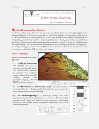
1. 1 | P a g e A A L
Applied Geoarchaeology Services
The Applied Anthropology Laboratories (AAL) provides geoarchaeological services. Geoarchaeology includes
the broad application of Earth science approaches to help resolve questions of archaeological significance. At
its core, geoarchaeology is multidisciplinary and includes aspects of Quaternary geology (sedimentology and
stratigraphy), geomorphology (landscape analysis), pedology (soil science), geochemistry, and archaeology
(among others). Incorporation of geoarchaeological approaches into research at the survey, eligibility testing,
and mitigation stages not only enhances the understanding of the archaeological record but often provides a
cost-saving advantage over more traditional CRM approaches. Review the list of services we offer and feel free
to contact us to explore how AAL can assist in your project.
Services Offered:
AAL staff have experience in various
approaches.
Landscape Assessment
and Analysis are used to
determine the geomorphic history
of a landscape and to determine
the potential that landforms
contain archaeological materials.
Analysis includes field
geomorphic mapping, GIS, and
LiDAR modeling procedures.
Soil Description and Particle-size Analysis are used to determine
depositional histories of landforms, identify buried sites, and can assess the
preservation potential of certain landscapes.
Soil Micromorphology is a microscopy technique that allows
examination of undisturbed soil properties and processes in thin section. This
approach reveals natural and cultural formation processes, archaeological
features and micro-debris, mineral composition identification, and organic
residue identification.
Arcscene representation of LiDAR data showing terraces and sand dunes at the NRHP-
listed Sandy Springs site, Adams County, Ohio 1
Profile CB-4 at the NRHP-listed Sandy Springs site,
Adams County, Ohio. Younger soil (Ap-Bw) over older
buried soil (2A-2BC-2C) showing a potential for intact
archaeological deposits 1
2. 2 | P a g e A A L
Hydraulic Coring and Backhoe
Trenching are commonly used to
investigate deeply buried deposits below
the reach of traditional CRM methods,
especially in alluvial (river) and colluvial
(hillwash) settings.
pH and Conductivity Analysis can be
used to characterize soil acidity and salinity
which are important for identifying
environments conducive to biological
preservation; as well as for understanding
various soil (and site) forming processes.
Organic Matter Concentration
(Loss-on-ignition) can be used to
characterize organic matter percentage
within sediments and often serves as an
indicator of anthropogenic inputs. When
coupled with hydraulic coring and
geochemistry, this technique provides clues
to the location of deeply buried deposits.
Principal Component Analysis (PCA) results classifying sediment samples by
depositional environment (e.g., alluvium, colluvium, aeolian, etc.) at the NRHP-
listed Sandy Springs site, Adams County, Ohio. Such analysis was used to identify
areas with high preservation potential for archaeological material 2
Micrograph of probable human excrement (mineralized
cess) with potential seed pseudomorphs in house basin fill at
the NRHP-listed Angel Mounds site in Vandenberg
County, Indiana (Cross-polarized light view). This finding
suggested that abandoned house basins also were used to
dispose of organic waste within the village 2
Micrograph of bone fragment in house basin fill at the NRHP-
listed Angel Mounds Site, Vandenberg County, Indiana (Plain-
polarized light view). Excavations had failed to identify macro-
faunal remains, but results of the micromorphology analysis
indicated that micro-fauna, likely in the form of organic waste, were
deposited in the abandoned basin 2
3. 3 | P a g e A A L
Geochronology and Absolute Dating Techniques are used to determine the age of cultural and
natural deposits. AAL staff are happy to assist in selecting the appropriate method for your project and
can assist in interpretation and Bayesian analysis of radiocarbon dates.
Archaeological Geophysics refer to a
variety of ground-based sensing technologies
used to create maps of various subsurface
properties, including potential archaeological
sites. AAL conducts Ground-penetrating
Radar (GPR), Magnetic Gradiometry,
Electromagnetic Resistivity and Magnetic
Susceptibility studies and have used these
techniques to map buried features and building
foundations, identify unmarked graves, map
burned areas at pre-contact sites, and assess site
integrity.
Flotation Analysis involves the recovery of micro-
botanical remains (e.g., charred seeds, charcoal, bone, and
nuts), and micro-artifacts using a Flote-Tech machine.
AAL can process your soil samples for you and help with
any identification or analysis.
Micrograph of Late Prehistoric Fort Ancient, shell-
tempered ceramic from the NRHP-listed Madisonville site
in Hamilton County, Ohio 3
GPR amplitude slice showing remnants of a buried
foundation, and other features under a parking lot in
Indianapolis, Indiana 4
Frequency dependent magnetic susceptibility map of site 33Ln15
showing areas of intense burning (white and light pink) 5
4. 4 | P a g e A A L
Soil Geochemistry includes the study of soil
elemental composition as a means to identify certain
enrichment and depletion that can provide clues of
human landuse. AAL has used geochemistry to map pre-
contact gardens, the extent of middens, and the presence
or absence of disturbance.
Portable X-ray Fluorescence (pXRF) is used to
determine the elemental properties of sediments,
ecofacts, and artifacts away from the laboratory. It can
be used to source raw materials including ceramics,
stone, glass, and metal. Since the technique is non-
destructive, pXRF is especially useful in projects where
destruction of the artifact under consideration is not an
option.
Key Personnel:
AAL staff are archaeologists that work within a CRM environment and have an intimate knowledge of
timelines, budgets, and providing results that can be incorporated into contract reports.
Matthew P. Purtill, PhD (ABD) (Geography, Geoarchaeology). Mr. Purtill has over 20 years of CRM
experience at all phases of investigation, formal geoscience training in pedology and geomorphology,
and training in GIS. He specializes in geoarchaeological approaches to archaeological problems at
multiple scales of study (region, site, artifact).
Kevin C. Nolan, PhD (Anthropology) Dr. Nolan has over a decade of archaeological experience,
including all phases of investigation. Dr. Nolan has published numerous articles, dozens of CRM
reports, and several Reports of Investigation using GIS, geochemistry, and geophysics to reveal the
hidden archaeological record.
Soil phosphate analysis indicated midden
soils at site 12D480. Even with few
artifacts, the integrity of the village midden is
apparent 7
GPR amplitude slice showing previously unmarked
graves, Delaware County, Indiana 6
5. 5 | P a g e A A L
AAL staff are available to discuss the requirements of your project and how geoarchaeology may be
applied to your project. To request a quotation, contact either Matthew Purtill (mpurtill@bsu.edu) or
Kevin Nolan (kcnolan@bsu.edu). We can also be reached at AAL by phone (765-285-5328).
References:
1Purtill, M. P. (2016). Aeolian and fluvial interaction in the middle Ohio River valley: New geomorphic, stratigraphic, and sedimentological evidence from
Sandy Springs, Adams County, Ohio. Geological Society of America Abstracts with Programs. Vol. 48, no.75, p.89, Denver.
2Purtill, M. P. (2013). An integrated geo-science approach for revealing the formation history of a Mississippian Period house feature at the Angel Mounds
Site, Indiana, U.S.A. M.A. Thesis, University of Cincinnati, Department of Geography, Cincinnati.
3Micrograph Credit: M.P. Purtill
4Balough, A., & Nolan, K.C. (2017). Ground-Penetrating Radar survey of the former McGowan Hall, Indianapolis, Indiana. Report prepared for
Knights of Columbus (AAL Project 16SP007). Applied Anthropology Laboratories, Department of Anthropology, Ball State University,
Muncie, Indiana.
5Nolan, K.C., Redmond, B.G. & Spielbauer, C.R. (2014). A rapid and inexpensive method for investigating community structure in the southwestern
Lake Erie Basin: A pilot study. Reports of Investigation 85, Volume 1 and 2, Applied Anthropology Laboratories, Department of
Anthropology, Ball State University, Muncie. Archaeological Research Reports, No. 165, Cleveland Museum of Natural History,
Cleveland, Ohio.
6Map Credit: K.C. Nolan
7Swihart, M.R. & Nolan, K.C. (2014). Investigation of Fort Ancient settlement and community patterns: An archaeological survey of Dearborn County,
Indiana. Reports of Investigation 83, Volume 1 and 2, K.C. Nolan (Ed.), Applied Anthropology Laboratories, Department of
Anthropology, Ball State University, Muncie, Indiana.