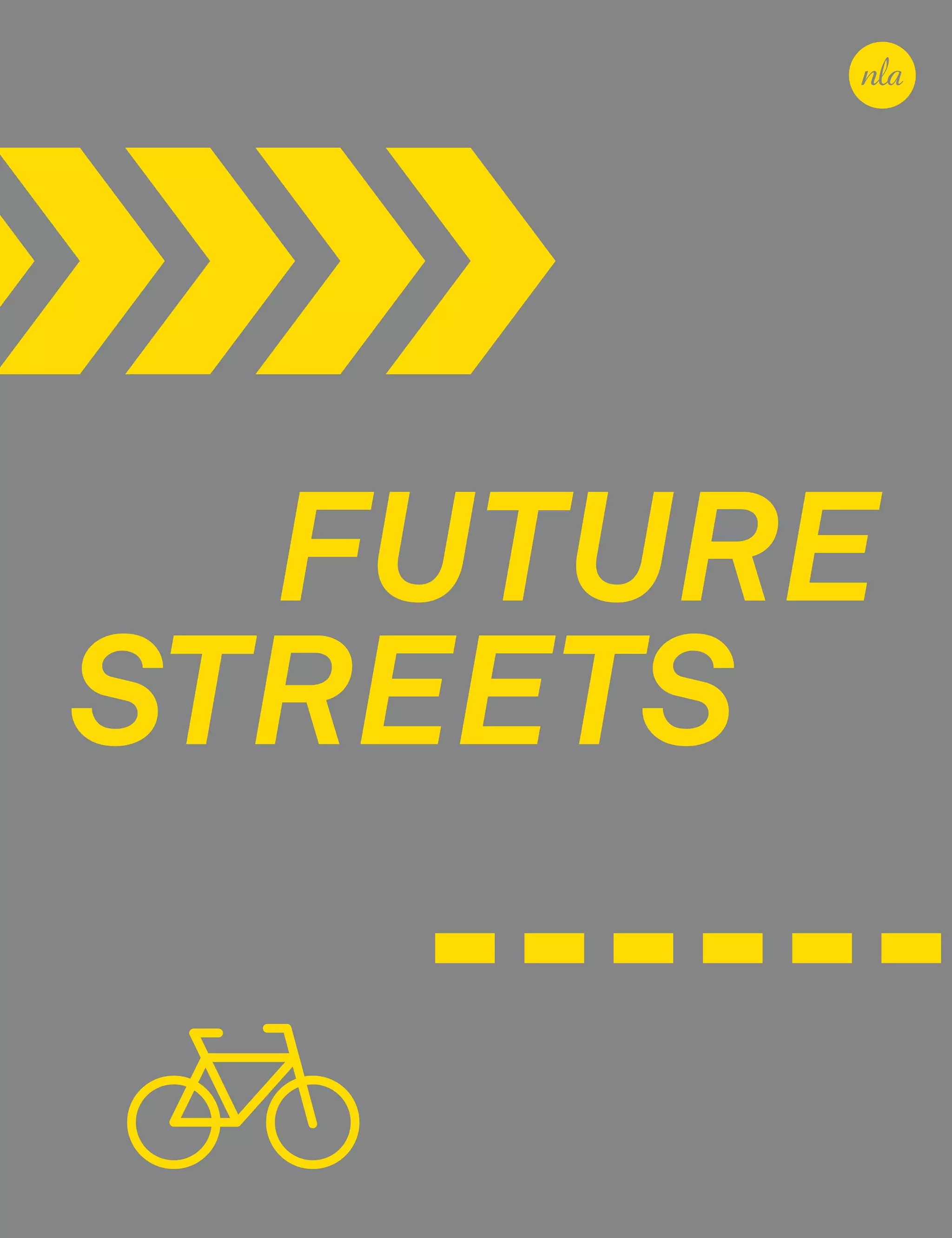
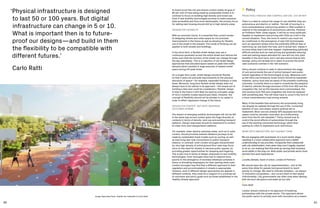
This document provides an introduction to the topic of future streets and mobility technologies. It discusses the importance of understanding how past transportation technologies have shaped urban form and the need to ensure new technologies serve human-centric goals like health, equity and sustainability. The document outlines key findings, including that technology should not determine outcomes, the "interregnum" period as new technologies emerge is crucial for shaping the future, and greater integration is needed between urbanists and technologists. It also emphasizes the central role streets play as public spaces and how changes to streets can transform society.

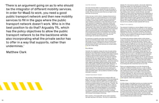
![40 41
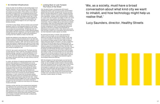
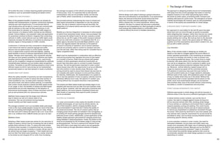
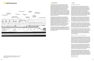
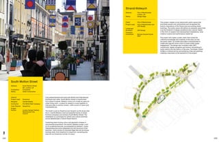
Introduction
The ‘heaven’ scenario envisions how the current trajectory
of reorienting streets towards human uses and their function
in supporting a healthy city can be continued. This scenario
examines how new mobility technologies might be used to
enhance and support existing efforts to design and plan for a
more human centric city, that moves away from 20th century
technologies. It suggests some of the policies and design
principles that will need to be employed in order to reach
this outcome.
In broad terms, the heaven scenario harnesses emerging
technologies that reduce the need for private vehicle
ownership and the number of single occupancy vehicles
through a greater emphasis on ‘shared mobility’, in turn
reallocating streets as public space and for active transport
modes. Continued investment in a strong public transport
network and increasing housing density in areas closed to
public transport will see a more liveable London emerge,
aligned with the Mayor’s vision for a healthier and more
equitable city.
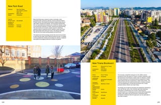
‘I like to imagine a future where shared mobility models
and self-driving cars reduce the number of vehicles on the
road, freeing up parking spaces that can then be reclaimed
and transformed into public spaces that serve different
social functions.’
Carlo Ratti, founder, Senseable City Laboratory,
Massachusetts Institute of Technology [MIT]
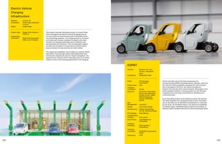
Automobiles
Alongside the safety benefits of CAVs, the heaven scenario
envisions that cars in the traditional sense cease to exist, and
are replaced entirely by shared electric vehicles operated
in fleets. The ultimate goal of policy and design responses
to automobiles in the future must be to mitigate against the
worst impacts they have created in the 21st century and
ensure they play a sustainable role within a multi-modal
system. Automobiles in this future are seen as simply one
option among a plethora of mobility services available via
a Mobility as a Service (MaaS) platform. Road pricing will
discourage short journeys made by private cars, while the
use of shared vehicles to connect to public transport is
encouraged. The following principles establish how cars
could fit into this vision of the future.
AUTONOMOUS FOR SAFETY
The safety benefits of all vehicles being autonomous are
undeniable. The National Highway Traffic Safety Administration
[NHTSA] crash analysis indicates that around 94 per cent of
all crashes are the result of human error, usually on the part
of the driver.33
In 2018, 58 pedestrians and 12 cyclists were
killed on the streets of London accounting for 62 per cent
of all road deaths in the capital.34
The adoption of level five
fully autonomous vehicles on the streets of London would
potentially lead to a complete elimination of such deaths,
allowing London to achieve its Vision Zero targets.35
For this to be a reality, it must be accompanied by continued
street redesign improvements that give greater space to
pedestrians and cyclists. It must be ensured that autonomous
vehicles always follow a hierarchy of street users and always
give right of way to the most vulnerable road users; namely
pedestrians, cyclists and other non-motorised mobility modes.
This guarantee of ceding the right of way must not come at
the cost of the pedestrian’s ability to cross the street as they
please. CAV technologies must not negatively impact upon
the way in which streets are designed—most pertinently,
pedestrians must not be restricted from their right to cross the
street freely. Moreover, as will be explored, the potentials for
reduced lane widths, reduced street clutter and generally less
auto-centric streets can be realised with complete automation.
To maximise the greatest potential safety benefits of AVs as
quickly as possible, Matthew Clarke proposes that highly dense
areas such as central London (in which the greatest safety
benefit from fully automated vehicles could be achieved) may
ultimately become ‘autonomous-only zones’ in which only
automated vehicles are allowed to enter on the grounds of
improved safety. Conversely, Andrew Roughan argues that
the complexities of getting an autonomous vehicle to function
safely in a dense urban context such as central London may
be too great, and that they are more suited to inter-urban and
sub-urban contexts. As such, central London areas may require
vehicles to be at least human supervised, killing the dream
of full autonomy. However, even human supervised vehicles
may still be equipped with much greater automatic breaking,
sensing capabilities and remote speed limitation, meaning that
the same safety benefits of full autonomy can still be realised.
In the same way that the Ultra-Low Emission Zone (ULEZ)36
zone has been implemented, Central London should become a
zone in which progressively more stringent vehicle autonomy
safety requirements are implemented, given that private car
usage is already very low. This could mean either requiring
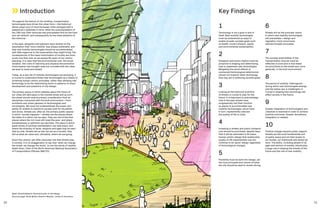
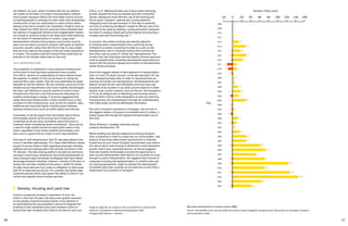
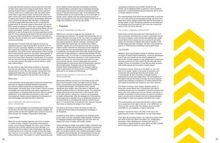
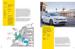
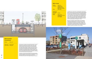
Los Angeles’s Vermont/Santa Monica intersection – ‘best case’
scenario, developed by Professor Andres Sevtsuk, director,
MIT City Form Lab.
Heaven Scenario](https://image.slidesharecdn.com/2019-11-nla-future-streets-publication-191116024418/85/Future-Streets-22-320.jpg)
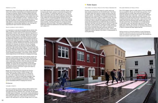
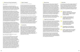


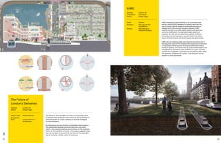
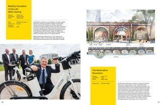
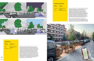
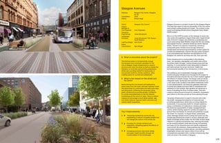
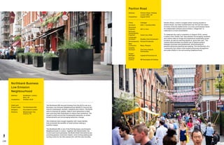
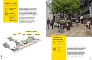
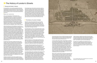
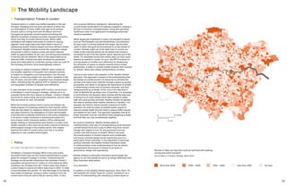
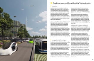
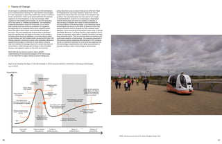
![148 149
This study carried out by Perkins+Will and NelsonNygaard
for Lyft, looked at the potential impacts that a shared AV
mobility environment could have upon a major arterial
boulevard located in the Los Angeles metropolitan area.
The location chosen for study was Wilshire Boulevard at
Veteran Avenue which is a major east-west arterial
boulevard, adjacent to the University of California’s Los
Angeles campus, that connects Beverley Hills and West
Hollywood to the east with Santa Monica to the west. This
specific location was chosen as it has both high-density
mixed-use development potential on its northeast corner
and is adjacent to the walkable Westwood Village on the
south side of the UCLA campus.
The study used the capacity figures for both the current
condition as well as for a future shared AV environment,
as specified by the National Association of City
Transportation Officials in their ‘Blueprint for Autonomous
Urbanism’. Following this numbers, it was felt that in
order to properly reflect the benefits of a shared mobility
environment, the capacity metrics needed to be changed
to reflect people-per-hour throughput instead of the
more traditional vehicles-per-hour throughput—the latter
privileging single occupant vehicles at the expense of
higher capacity shared vehicles or bus rapid transit.
For 2035 the modality-split for Wilshire Boulevard is based on
the assumption that there will be high-capacity AV bus rapid
transit, up to 50 per cent shared TNC, dedicated and protected
bike lanes with an enhanced sidewalk public realm that
encourages bike and pedestrian traffic. Using these modality
split data, and performance metrics which focuses on people
per hour instead of vehicles, the nominal Wilshire Boulevard
throughputs were 29,600 people-per-hour (pph) for its current
configuration and 77,000 pph for its 2035 and beyond.
We see a significant reallocation of space from an auto-
centric modality to transit and active- or micro-mobility.
Whereas currently Wilshire Boulevard has an overall
potential throughput of 29,000 pph, dedicating 88 per
cent of its right-of-way to automobiles and buses, the
shared autonomous high-capacity BRT scenario with a
potential throughput of 77,000 pph, dedicates 51.2 per
cent of its right-of-way to powered vehicles. This returns
36.8 per cent of the street’s curb-to-curb cross section
to active- or micro-mobility with dedicated and protected
lanes, wider more attractive sidewalks and storm-water
filtration gardens, enhancing the experiential appeal of what
currently could be characterized as a ‘traffic sewer’.
Ultimately this project re-examines the potential capacity
and efficiency of a street when analysed using capacity
measured as people-per-hour and not vehicles-per-hour
thus removing the inherent current bias against multi-
occupancy vehicles. This reconceptualizes the street to
reflect the evolving shared and autonomous trends in urban
mobility, shifting 37 per cent of the street right-of-way from
the current powered vehicle use to active transportation
(cycling and walking) and enhanced public realm uses.
Top 3 Improvements
1 Increase in throughput efficiency as
measured in people-per-hour (pph) from
29,000 pph to 77,000 pph (= 266 per cent
increase in efficiency).
2 Reclaims up to 37 per cent of the public
right-of-way from automobiles and
powered vehicles.
3 Provides for an enhanced, safer and more
sustainable public realm though wider
sidewalks, protected bike lanes and
stormwater run-off filtration beds.
What is innovative about this project?
It re-examines the potential capacity and
efficiency of a street when analysed using
capacity measured as people-per-hour and not
vehicles-per-hour thus removing the inherent
current bias against multi-occupancy vehicles. It
reconceptualises the street to reflect the evolving
shared and autonomous trends in urban mobility.
What is the impact on the street and
its users?
37 per cent of the street right-of-way is shifted
from the current powered vehicle use to active
transportation, such as cycling and walking, and
enhanced public realm uses.
Wilshire Boulevard Study
Address: Wilshire Boulevard, Los Angeles, USA
Status: Design stage
Client: Lyft
Project Lead
and Landscape
Architect: Perkins+Will [Mobility Lab]
Transport
Consultant: NelsonNygaard](https://image.slidesharecdn.com/2019-11-nla-future-streets-publication-191116024418/85/Future-Streets-76-320.jpg)
![Acknowledgements
NLA would like to thank our Programme Champions, Supporters
and contributors whose support made this study possible.
Special thanks to the following people for sharing their time,
expertise and insights, and their own research, via interviews,
discussions and/or participation in NLA workshops:
Antonio Balboa,
Vice President, Sales and Application,
Powertrain Solutions, Bosch
Phil Berczuk,
Director, Head of Design, Steer
Chris Birch,
Director of Sustainability, Hilson Moran
Riccardo Bobisse,
Associate, Steer
Matthew Clark,
Associate, Steer
Paul Curtis,
Associate Director, Vectos
Lucette Demets,
Head of Urban, London Partners
David Dew-Veal,
Strategy Consultant, KPMG
Richard Dilks,
Chief Executive, CoMoUK
Nicky Gavron,
Assembly Member, City Hall
Michael Hurwitz,
Director of Transport Innovation, Transport for London
Peter Jones,
Professor of Transport and Sustainable Development,
University College London
David Leopold,
Director, City Solutions, City Tech Collaborative
Greg Lindsay,
Director, Applied Research,
NewCities and Director of Strategy, CoMotion
George Lunt,
Technical Director, AECOM
Laura Mack-Titelius,
Head of London Connectory,
Urban Mobility Innovation Manager, Bosch
Eman Martin-Vignerte,
External Affairs, Governmental and Political Relations, Bosch
Danielle McGrellis,
Project Manager, UK Autodrive, Arup
Gavin Miller,
Director, MICA
Euan Mills,
Head of Digital Planning, Connected Places Catapult
Bruce McVean,
Acting Assistant Director, City Transportation,
City of London Corporation
Carlo Ratti,
Founder, Senseable City Laboratory,
Massachusetts Institute of Technology [MIT]
Stuart Robinson,
Strategic Planning Adviser, Transport for London
Andrew Roughan,
Managing Director, Plexal
Lucy Saunders,
Director, Healthy Streets
Andres Sevtsuk,
Associate Professor of Urban Science and Planning,
Massachusetts Institute of Technology [MIT] and Director,
City Form Lab
Rikesh Shah,
Head of Commercial Innovation, Transport for London
Michael Steinberg,
Head of Strategy, Programme and Communications,
Centre for Connected and Autonomous Vehicles (CCAV)
Sophie Thompson,
Director, LDA Design
Special thanks to Solomon Green-Eames, researcher
152 153
1 Joseph Rykwert, 1978. The Street: The Use of Its History
2 Robert Peberdy, n.d. Paths and Tracks. Victoria County History.
3 Appleyard, Donald. 1981 Livable Streets.
4 Jacobs, Jane. 1961. The Death and Life of Great American Cities.
5 Hebbert, M. 1993. The City of London walkway experiment. American
Planning Association, 59(4), 433-450.
6 Create Mobility Project. 2019.
7 Mayor’s Transport strategy. 2018.
8 Transport for London. 2019. Street Types for London.
9 Mayor’s Transport Strategy. 2018. pp.270.
10 City of London. 2019. Transport Strategy.
11 City of London. 2019. Transport Strategy pp.95
12 Parliament. 2019. The Government’s Cycling and Walking
Investment Strategy.
13 Dalton, Jane. 2018. Budget 2018: Environmental groups attack
government’s £30bn road spending plan. The Independent.
14 Centre for Connected and Autonomous Vehilces.
15 Gardner, Kevin., Melhuish, Tim., Mckenna, David and Rice, Thomas.
2006. The Benefits of bus priority within the central London
Congestion Charging Zone.
16 London Assmebly. 2017. London’s Bus Network.
17 Topham, Gwyn. 2019. London records biggest rise in cycling
journeys in 2018. The Guardian.
18 Mayor of London. 2019. Draft London Plan 2019.
19 McKinsey Company. 2018. Reserve a seat—the future of mobility
is arriving early.
20 Hall, Jonathon; Palsson, Craig and Price, Joseph. 2018. Is Uber a
substitute or complement for public transit?
21 Rao, Santosh. 2016. London’s new late night alternative: The Night
Tube + Uber. Medium and Uber Under The Hood.
22 Kim, Tammy. 2019. How Uber Hopes to Profit From Public Transit.
The New York Times.
23 Transport for London. 2019. PHVs and the Congestion Charge.
24 Transport for London. 2018. Private Hire Policy Statement.
25 SteerGroup. 2019. Dockless bike share: a regulatory grey area.
26 Transport for London. 2018. Dockless bike share code of practice for
operators in London.
27 Wakabayashi, Daisuke. 2018. Self-Driving Uber Car Kills Pedestrian
in Arizona, Where Robots Roam. The New York Times
28 Laker, Laura. 2018. Highly charged: complaints as electric car points
block city pavements. The Guardian.
29 Vincent, James. 2019. Transport app Citymapper gives up on
reinventing the bus. The Verge
30 Digit, 2019. Uber Chief Eyes Public Transport.
31 Zenzic. 2019. UK Connected and Automated Mobility
Roadmap to 2030.
32 Sevtsuk, Andres. 2019. The Future of Streets: Los Angeles. MIT City
Form Lab.
33 National Highway Traffic Safety Administration. 2015. National
Motor Vehicle Crash Causation Survey.
34 Vision Zero London. 2019. Latest Pedestrians And Cyclists
Deaths In London.
35 Transport For London. N.d. Who travels by car in London and for
what purpose? Roads Task Force.
36 Transport for London. 2019. Ultra-Low Emission Zone
37 Transport for London. Roads Task Force – Technical Note 14. Who
travels by car in London and for what purpose?
38 National Association for City Transportation Officials. 2019.
Blueprint for Autonomous Urbanism: Second Edition.
39 Morris, David. 2016. Today’s Cars Are Parked 95% of the Time.
Fortune.
40 Schmitt, Angie. 2019. Phoenix Rail Plan in Danger as Council Swipe
Cash. Streetsblog USA.
41 Section 106—An agreement whereby the planning applicant is
required to pay for off-site improvements to mitigate the impact of
the development.
42 Los Angeles Department of Transportation. 2019. Mobility Data
Standard.
43 Cherett, Tom. Allen, Julian. 2019. Last mile urban freight in the UK:
how and why is it changing? Government Office for Science.
44 McCarthy, Sebastian. 2019. London high streets beat UK vacancy
rates despite pressure from rising rents. CityAM
45 Onita, Laura. 2018. High Streets in London are worst hit for closures.
The Evening Standard.
46 Browning, Simon. 2019. I Drive in the Bus Lane. BBC News
47 Norton, Peter. 2011. Fighting Traffic: The Dawn of the Motor Age in
the American City. MIT Press
48 Wheels for Wellbeing. 2019. Guide to Inclusive Cycling.
49 Topham, Gwyn. 2018. Uber offers to share journey data with London
city planners. The Guardian.
50 Topham, Gwyn. 2019. All new UK cars to have speed limiters by
2022 under EU plans. The Guardian.
51 Forster, Andrew. 2018. London-wide byelaw explored to regulate
dockless bike hire. TransportXrta.
Endnotes](https://image.slidesharecdn.com/2019-11-nla-future-streets-publication-191116024418/85/Future-Streets-78-320.jpg)