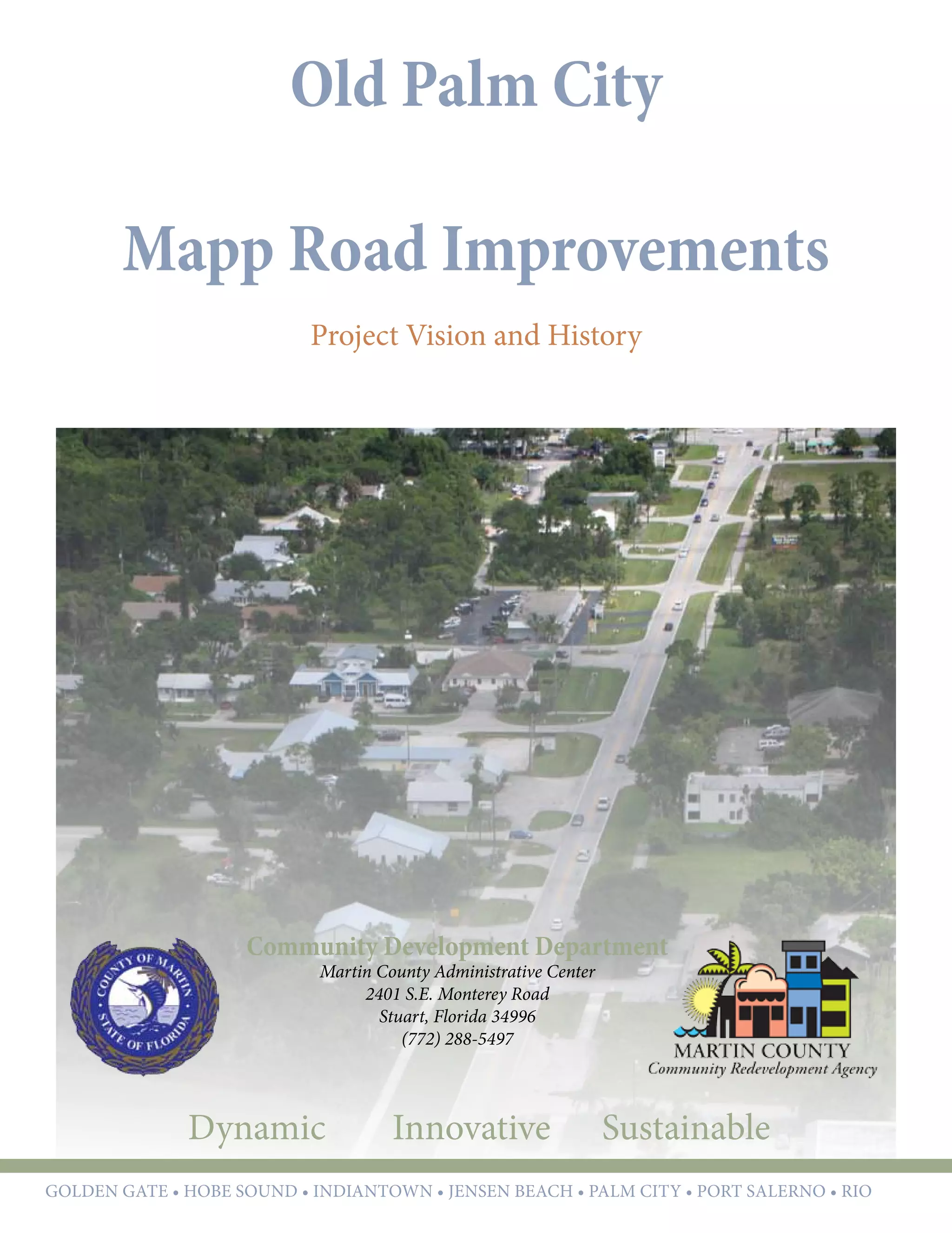
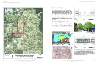
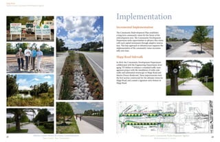
SlideShare a Scribd company logo
Old Palm City
Mapp Road Improvements
Project Vision and History
Community Development Department
Martin County Administrative Center
2401 S.E. Monterey Road
Stuart, Florida 34996
(772) 288-5497
Dynamic Innovative Sustainable
GOLDEN GATE • hobe sound • indiantown • jensen beach • palm city • port salerno • rio
Dynamic Innovative Sustainable
GOLDEN GATE • hobe sound • indiantown • jensen beach • palm city • port salerno • rio
Martin County Board of County Commissioners
District 1	 Doug Smith
District 2	 Ed Fielding, Chair
District 3	 Ann Scott, Vice Chair
District 4	 Sarah Heard
District 5	John Haddox
Martin County Community Redevelopment Agency
District 1	 Doug Smith
District 2	 Ed Fielding, Chair
District 3	 Ann Scott, Vice Chair
District 4	 Sarah Heard
District 5	John Haddox
Community development Staff
Kev Freeman, Director
Edward Erfurt, Urban Designer
Nancy Johnson, Community Development Specialist
Pinal Gandhi-Savdas, Community Development Specialist
Old Palm City................................................................ 4
Executive Summary...................................................... 6
Mapp Road Town Center Design
Project History.............................................................. 8
Community Redevelopment Plan
Zoning Overlays
Parking Study
Utilities and Stormwater Master Plan
NOW Visioning
Mapp Road ................................................................. 12
Following the Plan
TIGER II Grant Application
Stormwater Permit
Design
Maximizing the Benefit
Modular Design and Implementation
Implementation ......................................................... 22
Incremental Implementation
Mapp Road Sidewalk
Demonstration Rain Garden
Private Sector Investment
Parking Study
Table of Contents
Reconstruction of Mapp Road
Tuesday, September 25th
Time: 6:00pm
Palm City Community Center
2701 Cornell Street, Palm City, FL
4
Martin County Community Redevelopment Agency
Redevelopment in Action
Martin County Board of County Commissioners
Your County, Your Community
3
Old Palm City
CRA Area: Old Palm City
Plan Adoption: April 2002
Total Area: 610 Acres
Area Highlights:
•	 Waterfront Community
•	 Home to Several Targeted Businesses
Special Designations:
•	 Old Palm City Community Redevelopment Area
Area Summary
6
Martin County Community Redevelopment Agency
Redevelopment in Action
Martin County Board of County Commissioners
Your County, Your Community
5
Executive Summary
Mapp Road Town Center Design
Improvements for Mapp Road as outlined in the 2003
Old Palm City Redevelopment Plan included a desire
for an old-fashioned Main Street, on-street parking,
and a safe, well-connected corridor that allowed for
various modes of transportation including walking and
biking.
The CRA began in earnest in 2008 to make this project
a reality. Engineering design drawings were prepared
that included parallel parking, landscaped medians,
and construction of a stormwater management system
capable of handling future improvements.
In 2010, the design was updated utilizing more
innovative strategies such as head out angled parking
to replace parallel parking stalls, and rain gardens
to better incorporate best stormwater management
practices and improve environmental health. Center
medians were removed as a cost saving measure and
a modular design approach was introduced that did
not require the entire roadway to be constructed all at
once.
Through a series of public workshops led by staff in
2012, the community voiced their preference for a
simpler design that would allow for construction of the
entire corridor, rather than a modular approach.
Staff scheduled one-on-one meetings with business
owners along the corridor. The CRA received 50%
design plans in August 2014. The components of the
design will be prioritized in keeping with the Com-
munity’s desire. With $1.3 million available in TIF
for construction, the CRA will phase the project that
aligns with the available TIF dollars.
Project Type:
•	 Complete Streets
•	 Innovative Stormwater Management
Funding Source:
•	 Tax Increment Financing (TIF)
Status:
•	 In Design
Project Manager: Pinal Gandhi-Savdas
SW Mapp Road
Typical Section
7’-10”17’8’
Existing Right-of-Way Width = 100 feet
Proposed Improvement Width = 100 feet
Pedestrain Facilities
8
Martin County Community Redevelopment Agency
Redevelopment in Action
Martin County Board of County Commissioners
Your County, Your Community
7
Project History
Old Palm City
T:gmdldrscodificationall_codes_codifiedart3_div6_CRA_inhouse_codart3_div6_CRA_11-15-06.doc
OLD PALM CITY
MARTIN COUNTY, FLORIDA
11
OLD PALM CITY
MARTIN COUNTY, FLORIDAB. OVERLAY DISTRICTS
ARCHITECTURAL REGULATIONS 2. BUILDING ELEMENTS
A. ORIENTATION & CONTEXT
The Overlay Zoning Code requires all
buildings to be constructed relatively close to the
street to produce a pedestrian friendly streetscape.
All off street parking is restricted to the rear or side
yards.Abuilding must be designed with a prominent
front elevation and entrance along the major road it
fronts on. Where a rear or side lot parking is
provided, a corresponding entrance must also be
provided.
All buildings must be designed to relate to
its context specifically to any new or newly
redeveloped building(s) on the same block, or in
the near vicinity. Two and three story buildings must
relate to one story neighbors by special articulation
of the first floor, through architectural treatments
such as expression lines and arcades, etc. The
purpose of these treatments is to maintain the
appearance of a continuous ground story level. The
goal is for a unified building image within each block
or vicinity, not identical buildings.
OLD PALM CITYM A R T I N C O U N T Y , F L O R I D A
COMMUNITY REDEVELOPMENT AREA PLAN
A d o p t e d A P R I L 2 2 , 2 0 0 3
Revised October 2009
PARKS & OPEN SPACE
Future
Fire
StationTown
Square/
Amphitheatre/
Historic
Village
Future
Commercial
Development
Future
Stormwater Retention
with Gathering Space
and Passive Park
Post
Office
To Elemetary
School/Church
MARTIN
DOWNSBLVD
SW27thST
SW28thST
SW29thST
(SW30thST)
SW31stST
SW32ndST
SW33rdST
SW34thST
SW34thTER
SW35thST
SW36thST
MAPP ROAD CONCEPT FEATURES
1. Types of uses:
- Grocery store
- Gourmet/specialty
- Mixed use preferred
- Community/neighborhood draw
- Limited destination shops
- Old-fashioned Main Street
- Town square (by fire station)
- Turning lanes
- Osceola-like street
- On street parking
- Overflow parking
- No suicide lane
- Connect alleys and parking behind buildings
- Gateway where merge ends
2. Mapp Road Neighborhood Center Form
- Traditional Main Street (portion of it)
- Nodes preferred over strip - multiple nodes
- Don't reduce connectivity of dead end streets
- Walk-ability
3. Physical character:
- Two story varied
- Avoid intensity at 34th St. area (PC Elementary)
- Development - 10-15 units per acre, density max
- Parking in rear of building
- Common areas incorporated into commercial spaces, gathering spaces
- Shared parking (residential/commercial)
- Off-premises signage
Existing
Church
VISION PLAN
MAPP ROAD
CONCEPT PLAN 17
OLD PALM CITY CRAM A R T I N C O U N T Y , F L O R I D A
Existing Fuel/
Convenience Store
Existing
Apartments
Future 2-Story
Townhouses
Existing
Retail Center
Future Retail/Office 1st Floor
Residential Units 2nd Floor
Mixed Use
Office/Retail
PARKS & OPEN SPACE
Public Space
KEY
Commercial 1st
floor with
Residential/Office
on 2nd Floor
2 Story Townhouse
Development(s)
Civic Uses
Park/Gathering
Space
Mapp Road "Main
Street" - 2 travel lanes
with parallel
parking/sidewalks
on each side, turning
lanes, street trees.
Future
Fire
Station
Future
Public
Space/
Historic
Village Future
Commercial
Future
Stormwater
Retention/Park
with Gathering
Space
Post
Office
To Elemetary
School/Church
MARTIN
DOWNSBLVD
SW27thST
SW28thST
SW29thST
(SW30thST)
SW31stST
SW32ndST
SW33rdST
SW34thST
SW34thTER
SW35thST
SW36thST
BREAKOUT GROUP #1 ASSIGNMENT- MAPP ROAD
Workshop participants were asked to address specific issues that have been
identified as most essential:
1. What types of uses should be permitted within the Mapp Road
Neighborhood Center: Mixed Use versus Commercial?
2. What form should the Mapp Road Neighborhood Center take:
Commercial Nodes vs. Strip?
3. What would be the preferred physical character be of the
Neighborhood Center: what should the limit be for building height,
development density, front/side/rear yard building setbacks, location
and provision for parking, etc.?
MAPP ROAD GROUP COMMENTS
1. Types of uses:
- Grocery store
- Gourmet/specialty
- Mixed use preferred
- Community/neighborhood draw
- Limited destination shops
- Old-fashioned Main Street
- Town square (by fire station)
- Turning lanes
- Osceola-like street
- On street parking
- Overflow parking
- No suicide lane
- Connect alleys and parking behind buildings
- Gateway where merge ends
- Alternative East/West road?
2. What form should Mapp Road Neighborhood Center take?
- Traditional Main Street (portion of it)
- Nodes preferred over strip - multiple nodes
- Don't reduce connectivity of dead end streets
- Walk-ability
- Keep nodes away from fire station
- Keep nodes away from north and south
3. Preferred physical character:
- Two story - three story varied
- Avoid intensity at 34th St. area (PC Elementary)
- Development - 10-15 units per acre, density max
- Parking in rear of building
- Common areas incorporated into commercial spaces, gathering spaces
- Shared parking (residential/commercial)
- Off-premises signage
Church
The participants agreed on a traditional "Main Street" model for the form and character of Mapp Road. It was felt that such a scenario would satisfy a variety of
needs for Palm City residents: retail, civic buildings (both existing and proposed) community gathering space, walkable destinations, a "heart" of the community. It
was understood that the entire distance from Martin Downs Blvd. to 36th Street could not sustain a healthy retail environment, but that some portion would be
more appropriate as traditionally styled townhouse development. This would further reinforce the small town character that many seek to preserve and build upon
in the Old Palm City area. One notable aspect of the conceptual plan is the inclusion of two community gathering spaces, one in the area of the proposed
stormwater retention/park, and another more plaza-like space surrounded by relocated historic buildings and fronting Mapp Road in the anticipated historic
village. The two public spaces will be connected by retail uses which allow for offices or residences on the second floor.
WORKSHOP SUMMARY
1. RETROFIT MAPP ROAD
AS "MAIN STREET" 16
Example Block (see page 18)
OLD PALM CITY CRAM A R T I N C O U N T Y , F L O R I D A
Future
Mapp Road
Professional
Plaza
(2-story office)
Mixed Use/
Office/Retail
CONSENSUS
A note on the format of this section: The Workshop Summary is an unedited listing of comments received at the July 2002 Palm City Neighborhood Design
Workshop from the individuals who participated in the breakout group dedicated to the issue. The Vision Plan is the final vision, incorporating comments from the
workshop, Palm City Neighborhood Advisory Committee, government agencies, and other concerned citizens. Please refer to the Vision Plan for the final design,
not the Workshop Summary.
PARKS & OPEN SPACE
VISION PLAN
MAPP ROAD - DETAILS 18
OLD PALM CITY CRAM A R T I N C O U N T Y , F L O R I D A
2 Story Building
11,000 SF Retail/Office 1st Floor
10 - 1,100 SF Residences or Offices 2nd Floor
2 Story Building
7,800 SF Retail/Office 1st Floor
8 - 975 SF Residences - or Offices 2nd Floor
1.65 Acre Site (71,800 SF)
18,800 SF Retail/Office - 72 Parking Spaces @ 4 Spaces per 1,000 SF
18 Residential Units (18,800 SF total)
- 28 Parking Spaces @ 1.5 per Residence
Total Square Feet: 37,600
Total Parking Needed: 100 Spaces
Total Parking Provided: 100
92 Spaces on Site, 8 Spaces on Street Parking
Example Block Site Data
Conceptual Mapp Road Cross-Section
Parking
Lane
5' Tree
Grate
5' Bike
Lane
11' Sidewalk
Curb
Street Light
Area enlarged below
Enlarged Side Walk Detail
Community Redevelopment Plan
The Old Palm City Community Redevelopment
Area was established in 2001 by the Board of County
Commissioners. The boundaries of the redevelopment
area highlighted the infrastructure constraints in the
older neighborhoods, the Old and New Palm City
competing for commercial activity/redevelopment, the
number of vacant commercial lots, and the high code
enforcement activity within the Old Palm City Area.
Throughout 2002, numerous public workshops
where held to seek input from the community. This
information was documented and included in the
Old Palm City Community Redevelopment Plan. The
key issue included in the report was the proposed
character and vision for the future of the Mapp Road
Corridor.
The Board of County Commissioners adopted the
Old Palm City Community Redevelopment Plan in
April 2003. Input from workshop provided basis of
components of the Redevelopment Plan. Mapp Road
was proposed to be retrofitted as Old Palm City’s
“Mainstreet,” and is detailed as a two-lane, pedestrian-
friendly, mixed use corridor with on-street and shared
parking; median nodes of two-story commercial and
residential uses; a town square/amiphitheater/historic
village, and storm water retention with gathering space
and a public park.
Above: Design regulations and overlay zoning
requirements for Mapp Road have been adopted to
implement the community vision for Mapp Road.
Above: Extensive planning occurred for Mapp Road with
the public and the NAC in preparation of the adoption of
the Redevelopment Plan.
Left: Utility and Stormwater Planning was completed for
all of Old Palm City to guide priorities of projects.
Zoning Overlays
The Board of County Commissioners adopted the
Old Palm City Zoning Overlays in November 2004
which supported the community vision through the
Martin County Land Development Regulations. These
regulations provided the opportunity for small scale
infill and mixed-use development along Mapp Road.
However, the lack of infrastructure and flooding
made it difficult for the redevelopment. There was also
no clear idea how the county was going to manage
stormwater issues in the area which led to uncertainty
in future finished floor elevation requirements and
road elevations, which resulted in disinterest in private
investment
Mapp Road
Martin County Community Redevelopment Agency
Old Palm City Community Redevelopment Area
10
Martin County Community Redevelopment Agency
Redevelopment in Action
Martin County Board of County Commissioners
Your County, Your Community
9
Parking and
Transportation
in Community
Redevelopment
Areas
A case study of the Hobe Sound
and Old Palm City CRAs
September, 2006
26 27
Neighborhood street design
The following section diagrams illustrate how the rights-of-way will be divided in Old Palm
City. They should be used to guide road paving projects and sidewalk and on-street parking
construction. The design of 34th Street is particularly important because the street is the
principle access way for Old Palm City residents to Palm City Elementary School. Pedestrian
and bicycling facilities on this street must be the top priority here.
Left: Proposed Mapp Road design
Middle left: Sunset Trail
Bottom left: 34th Street
Bottom right: Typical 50-feet ROW
Property access and rights-of-way
Mapp Road is somewhat unusual for a commercial district in that blocks front it on their
shortest edge. While creating T-shaped alleyways would be one solution for this development
pattern, it is unworkable in Palm City because commercial development is only allowed on one
half of most blocks. Residents would likely resist alleyways being retrofitted to their properties;
however it could be required as a condition for future redevelopment. Instead, it is desirable to
locate parking and other access ways to the portion of the property furthest from Mapp Road.
This will create a continual street frontage on the primary roadway but will have the undesirable
effect of separating the nearby residential uses from the town center with parking lots and
Parking Study
In 2006, Community Development Department Staff
evaluated the parking needs for the redevelopment
areas following the principles promoted by famed
University of California Professor, Donald Shoup.
Shoup’s work book “The High Cost of Free Parking,”
had recently been published which explains how better
parking policies can improve cities, the economy, and
the environment.
This report outlined a series of key elements needed
to implement transportation improvements that are
part of the Palm City and Hobe Sound Redevelopment
Plans. Such improvements include:
•	 Generous sidewalks
•	 Shade trees, benches, and awnings to make the
sidewalk more inviting
•	 Less on-site parking and less of it visible from
the main street
•	 More on-street parking, shared parking among
several businesses, parking lots and parking
garages
•	 Encourage more people to walk or bicycle to
the downtown area
•	 Encourage people to park once and walk to
multiple stores or offices
•	 Encourage more compact development and
discourage the unnecessary use of increasingly
valuable land for surface parking.
The parking study also highlighted the need to create
a unified parking code with shared and reduced
parking rates for redevelopment, the establishment of
a parking trust fund, and utilizing public rights of way
for on-street parking to meet redevelopment parking
requirements.
This report was shared with the Neighborhood
Advisory Committees, local businesses, and local
chamber of commerce. These ideas were also
implemented into the Martin County Land Code,
and utilized in the redevelopment of parcels in the
Community Redevelopment Areas.
Above Exerts from the parking study specific to the Community
Redevelopment Overlays for Old Palm City, including the inventory
of existing parking and possible parking configurations.
25
Public transit
The Martin County Council on Ageing operates the Community Coach service throughout
Martin County. Though it is technically a public transit service for all residents, it is not suitable
or use by the general public. No fixed-line service operates in Old Palm City.
Automobile facilities
Mapp Road is a two-lane collector road. It is primarily a pass-through street with only a
ew destinations along the road. The road’s large right-of-way and the abundance of vacant
and fronting the street encourages drivers to pass quickly and to pay little attention to the
urrounding environment. There are turning lanes at Martin Downs Boulevard, 34th Street,
nd Martin Highway/36th Street. Sunset Trail will be a significant connection for the western
half of Palm City to the town center.
There are currently 503 off-street parking spaces in the commercial district servicing
70,518 sq ft of commercial space, 22,770 sq ft of light industrial and storage facilities, a post
office, and a fire station. All parking spaces are privately held off-street. Some parking spaces
would become inaccessible when on-street parking is installed, though.
PILOP implementation
The Old Palm City Parking Fee District encompasses properties in the mixed-use overlay that
an easily share of parking facilities both on- and off-street. The district does not incorporate
ommercial property in close proximity to the overlay, though it could easily be expanded to
nclude such properties in the future.
Existing parking
Commercial 350
Industrial/storage 75
Post Office 48
Fire Station 30
Total 503
Martin Downs Boulevard
28th St
29th St
30th St
29th Ter
Thelma St
Sunset Trail
31st St
32nd St
33rd St
34th St
35th St
36th St
MappRoad
35th Ter
Martin Highway
Below left: Existing parking in Old
Palm City, shown in red.
Below right: The Old Palm City
Parking Fee District. It’s boundaries
coincide with the town center overlay.
Martin Downs Boulevard
28th St
29th St
30th St
29th Ter
Thelma St
Sunset Trail
31st St
32nd St
33rd St
34th St
35th St
36th St
MappRoad
35th Ter
Martin Highway
geing operates the Community Coach service throughout
ally a public transit service for all residents, it is not suitable
ed-line service operates in Old Palm City.
r road. It is primarily a pass-through street with only a
he road’s large right-of-way and the abundance of vacant
drivers to pass quickly and to pay little attention to the
e turning lanes at Martin Downs Boulevard, 34th Street,
unset Trail will be a significant connection for the western
.
treet parking spaces in the commercial district servicing
22,770 sq ft of light industrial and storage facilities, a post
g spaces are privately held off-street. Some parking spaces
-street parking is installed, though.
strict encompasses properties in the mixed-use overlay that
both on- and off-street. The district does not incorporate
mity to the overlay, though it could easily be expanded to
e.
Existing parking
Commercial 350
Industrial/storage 75
Post Office 48
Fire Station 30
Total 503
Martin Downs Boulevard
28th St
29th St
30th St
29th Ter
Thelma St
Sunset Trail
31st St
32nd St
MappRoa
Below left: Existing parking in Old
Palm City, shown in red.
Below right: The Old Palm City
Parking Fee District. It’s boundaries
coincide with the town center overlay.
28th St
29th St
30th St
31st St
32nd St
27
ss to properties will likely result in a larger number of curb cuts in Old Palm
ce the supply of on-street parking on streets other than Mapp Road. These
to a minimum by incorporating disincentives to small surface parking lots.
mmended that curb cuts not be allowed for parking areas that will contain
king spaces.
locations of spaces
no on-street parking spaces in Old Palm City but a few businesses have
t would be either inaccessible or undesirable when on-street parking is
y opportunities for on-street parking in the town center overlay. The Mapp
is large enough to accommodate on-street angled parking. Or, this right-
ed to create larger sidewalks and landscaped areas. The community favors
n-street parking can be added to all other local streets inside the town center
t parking is installed it should not be removed. If a developer wants to
e must provide an equal number of public parking elsewhere, either through
n-street spaces or a garage space. He cannot replace public on-street spaces
eet parking spaces. As properties are redeveloped, their curb cuts will be
reet spaces must be installed on Mapp Road. On other streets it might be
ccess to parking areas. Constructing angled parking on Mapp Road could
226 spaces.
Rights-of-way
Mapp Road 100’
Sunset Trail 60’
All others 50’
Potential on-street parking
Mapp Road (parallel) 281
Other streets 367
Total 648
re installed, five land uses in Old Palm City
5 parking spaces. This leaves 613 spaces to
inesses. The on-street spaces will be divided
and developers can buy on-street PILOP
e district in which their property sits. This
lopers are not paying for on-street spaces far
ment.
n-street parking spaces can be constructed in
he exact number is not known because curb
final number. Since Old Palm City’s road
d itself well to access alleyways, curb cuts
ate reality. It is reasonable to expect around
ss streets, which will reduce the number of
least 65, leaving only 583 spaces.The $3.21
tructing these 583 spaces will be distributed
king spaces sold in the PILOP on-street
he cost per space sold, then, will be $5,851.
Martin Downs Boulevard
28th St
29th St
30th St
29th Ter
Thelma St
Sunset Trail
31st St
32nd St
33rd St
34th St
35th St
36th St
MappRoad
35th Ter
Martin Highway
Below: Proposed on-street parking
and the three on-street districts.
required buffers.
Providing access to properties will likely result in a larger number of curb cuts in Old Palm
City. This will reduce the supply of on-street parking on streets other than Mapp Road. These
cuts should be kept to a minimum by incorporating disincentives to small surface parking lots.
Therefore, it is recommended that curb cuts not be allowed for parking areas that will contain
fewer than five parking spaces.
The number and locations of spaces
There are currently no on-street parking spaces in Old Palm City but a few businesses have
parking spaces that would be either inaccessible or undesirable when on-street parking is
implemented.
There are many opportunities for on-street parking in the town center overlay. The Mapp
Road right-of-way is large enough to accommodate on-street angled parking. Or, this right-
of-way could be used to create larger sidewalks and landscaped areas. The community favors
parallel parking. On-street parking can be added to all other local streets inside the town center
overlay as well.
Once on-street parking is installed it should not be removed. If a developer wants to
create a curb cut, he must provide an equal number of public parking elsewhere, either through
purchasing other on-street spaces or a garage space. He cannot replace public on-street spaces
with private off-street parking spaces. As properties are redeveloped, their curb cuts will be
forfeited and on-street spaces must be installed on Mapp Road. On other streets it might be
desirable to grant access to parking areas. Constructing angled parking on Mapp Road could
create an additional 226 spaces.
Rights-of-way
Mapp Road 100’
Sunset Trail 60’
All others 50’
Potential on-street parking
Mapp Road (parallel) 281
Other streets 367
Total 648
PILOP costs
On-street spaces
As on-street spaces are installed, five land uses in Old Palm City
will lose a total of 35 parking spaces. This leaves 613 spaces to
be sold to other businesses. The on-street spaces will be divided
into three districts and developers can buy on-street PILOP
spaces only from the district in which their property sits. This
Martin Downs Boulevard
28th St
29th St
29th Ter
Below: Proposed on-street parking
and the three on-street districts.
59 | P a g e
Martin County CRA Old Palm City 5
ACTIVITY FOCUS
Recommended Activity Focus
1. MAPP ROAD
Create a context sensitive street
2. WATERFRONT/PARK
Boardwalk, public/private partnership
Recommendation
The Community confirmed that CRA Activity Focus should
be maintained towards the implementation of the Mapp
Road Retrofit. Grant opportunities have been identified
that would facilitate a context sensitive street design
together with a sewer system expansion.
Activity Focus should also be placed on the desire to better
utilize the waterfront and the Jock Leighton Park area.
Partnerships between the public and private sectors
should be sought, together with grant opportunities that
would provide opportunities to revitalize the park area.
1
2
Utilities and Stormwater Master Plan
The Community Redevelopment Agency recognized
that the lack of public utilities continued to be
the biggest deterrent for redevelopment in the
redevelopment areas.
In 2006, the Community Redevelopment Agency
completed the Utilities and Stormwater Master Plan
for Old Palm City which included a conceptual design
and cost to complete all the necessary utilities and
stormwater improvements for Old Palm City.
This Master Stormwater/Utility Plan provides guideline
for construction and funding of infrastructure
improvements necessary to meet the needs of Old
Palm City in accordance with the Community
Redevelopment Plan and the Neighborhood Advisory
Committee’s vision for the future for Mapp Road.
In 2007 the Mapp Road improvements of the
stormwater and utilities master plan was identified as
the top priority for Old Palm City.
NOW Visioning
In 2009, the Community Development Department
hired a new Director, Kev Freeman. He began a series
called the Neighborhood Opportunities Workshop
(NOW) Visioning. These two day public workshops
provided the residents, property owners, and business
owners of the community redevelopment area a venue
to share the strengths, weaknesses and opportunities of
their community. This public input built consensus on
the Recommended Activity Focus areas.
The residents of Old Palm City focused on two activity
focus areas; Mapp Road and the Waterfront. Residents
overwhelming wanted to see Mapp Road transformed
in a context sensitive street.
The Community confirmed that CRA Activity Focus
should be maintained towards the implementation
of the Mapp Road Retrofit. Grant opportunities have
been identified that would facilitate a context sensitive
street design together with a sewer system expansion.
Activity Focus should also be placed on the desire to
better utilize the waterfront and the Jock Leighton
Park area. Partnerships between the public and
private sectors should be sought, together with grant
opportunities that would provide opportunities to
revitalize the park area.
12
Martin County Community Redevelopment Agency
Redevelopment in Action
Martin County Board of County Commissioners
Your County, Your Community
11
Mapp Road
Following the Plan
In accordance with the vision in the adopted Old
Palm City Community Redevelopment Plan,
and the recommendations of the Master Utilities
and Stormwater Master Plan, the Community
Redevelopment Agency began the planning and design
work for the implementation of Mapp Road.
The magnitude of this project required a phased
approach. The most critical issue for the project was
the design of the stormwater management system. In
July 2008 the Community Redevelopment Agency
contracted with Boyle Engineering Corporation
(Acquired by AECOM) to prepare roadway design
for Mapp Road which included, design, construction
documents for water quality/water retention facilities,
and anticipated roadway elevations. (Contract for
$400,000)
In May 2009 a master permit application was
submitted to South Florida Water Management
District (SFWMD) This master stormwater permit
included a conceptual design for the roadway, and
assumed the stormwater treatment need based on
impervious ROW for the entire length of Mapp Road.
This permit and design could be modified as portions
of Mapp Road were designed and constructed.
TIGER II Grant Application
In July 2010, the Community Redevelopment
Agency applied for Tiger II Grant from the Federal
Department of Transportation for $11.5 million.
This grant would have provided funding for all of the
improvements on Mapp Road corridor and fund the
expansion of utilities to the residential neighborhood.
This grant illustrated the complexity and cost when
retrofitting existing neighborhoods, and the need for
completed engineering drawings for these applications.
The CRA was not awarded this grant.
Mapp Road
Martin County Community Redevelopment Agency
Old Palm City Community Redevelopment Area
14
Martin County Community Redevelopment Agency
Redevelopment in Action
Martin County Board of County Commissioners
Your County, Your Community
13
Mapp Road
SW Corrine Ave
Ditch
Water Management
Parcel
SWMAPPRD
SW 34 TH ST
SWCORNELLAVE
SW 35 TH ST
SW 28 TH ST
SWFEROEAVE
SW 29 TH ST
SW MARTIN DOWNS BLV
SW 34 TH TER
SW 36 TH ST
SW 31 ST ST
SW 30 TH ST
SW SUNSET TRL
SW 33 RD ST E
SW MARTIN HWY
SW THELMA ST
SWREILLEYAVE
SW 32 ND ST
SW 36 TH TER
SW ULMUS PL
SW NAOMI ST
SW 37 TH ST
SW 27 TH ST
SW 29 TH TER
SW
SILVER PINE WAY
SWEARLAVE
SW WHISPERIN
G
SO
U
N
D
D
R
SW SPRUCE ST
SW NIKOMA ST
SWCONCHCOVELN
SW 25 TH TER
SWIMMANUEL
DR
SW PINELAND WAY
SW 29 TH TER
SW 27 TH ST
SWFEROEAVE
Mapp Road Town Center Improvements
Storm Water Management Project
G:henry-mprojectsRichardMapp Road Survey.mxd
Ë
0 600
Feet
1 inch equals 600 feet
Project Area
Parcels
January 03, 2008
Figure 1
Stormwater Permit
The master stormwater permit provided a solution
for the stormwater issues for Mapp Road. The permit
allowed for the construction of a combination of wet
and dry stormwater management system. The permit
required the restoration of historic wetlands, and
connected to several existing systems. This marvel of
engineering would create an almost 20 acre stormwater
management parcel on Mapp Road within the Mixed-
Use overlay.
The proposed system would collect all of the
stormwater for Mapp Road from Martin Downs to
Martin Highway, and pipe it to center of Mapp Road.
The large amount of land was required for this system
due to the outfall constraints of the Danforth Creek.
Above These are the possible roadway sections for Mapp Road that
were developed as a result of the Community redevelopment plan.
Left Top This illustration shows the composition and size of the
proposed stormwater parcel. The large wet pond, shown in blue, is
required to hold the stormwater from Mapp Road, until it could be
slowly discharged into the Danforth Creek.
Mapp Road
Martin County Community Redevelopment Agency
Old Palm City Community Redevelopment Area
16
Martin County Community Redevelopment Agency
Redevelopment in Action
Martin County Board of County Commissioners
Your County, Your Community
15
Design
With the stormwater permits in hand, and the
community support from the NOW Visioning, the
CRA authorized a contract with AECom to develop a
demonstration design for Mapp Road in March 2011.
This design work was assigned to the Martin County
Engineering Department to manage, and included
the cost to build the stormwater treatment parcel and
a portion of the Mapp Road from SW Ulmas St to SW
29th Terrace (1,100 linear feet) (Contract for $310,000)
This planning included a community workshop held
in a shop front on Mapp Road. Residents, property
owners, county staff, and the franchise utility
providers, participated in the workshop. Through
this process, consensus was formed for the proposed
roadway section which minimized the disruption
to local businesses. The design also included several
cost construction savings recommendations such as
utilizing the existing pavement of Mapp Road.
As the design progressed in November 2011, the
cost estimate exceeded the budget and available Tax
Increment Funding (TIF). This required some value
engineering such as eliminating undergrounding
utilities portion of the project. The estimated cost for
this first phase of the project was $2,043,585 for small
roadway section and stormwater treatment area.
In February 2012, the 100% design completed for
the demonstration project. At this same time, the
Community Development Department hired a project
engineer familiar with roadway retrofits. Community
Development Staff began analyzing the design in
search of additional cost savings. Staff found that
existing stormwater treatment areas and existing pipes
currently accommodates existing stormwater on Mapp
Road. Staff also explored strategies and materials in
the stormwater toolkit to find innovative treatment
strategies to reduce overall costs to allow more of the
roadway to be improved. These new findings began to
eliminate the high costs and need for the stormwater
treatment parcel.
Reconstruction of Mapp Road
Tuesday, September 25th
Time: 6:00pm
Palm City Community Center
2701 Cornell Street, Palm City, FL
Top: All of the ideas from the community workshop
were organized on a project board that was distributed
throughout the community. This poster was also printed
on a 4x8 billboard and posted on the corridor at the
intersection of Sunset Trail.
Above and Left: Mapp Road property owners opened
a shop front for the use of a community studio where
residents could participate in the engineering for Mapp
Road. Engineers met with residents, business owners,
and County Staff over several days.
The Community Redevelopment Agency began
seeking additional funding sources through grants in
August 2012. These grants would provide the funding
to construct the entire stormwater treatment area. Half
of the stormwater treatment area is outside of CRA
boundary, so funding would have to be a source other
than TIF.
By September 2012, the CRA was notified that
the various grants were not awarded. Community
Development Staff continued to research seeking the
best way to maximize TIF funds, and implement the
Mapp Road Project. This required staff to explore ideas
outside the box.
Mapp Road
Martin County Community Redevelopment Agency
Old Palm City Community Redevelopment Area
18
Martin County Community Redevelopment Agency
Redevelopment in Action
Martin County Board of County Commissioners
Your County, Your Community
17
Community Redevelopment Agency
County Administrative Center
2401 S.E. Monterey Road
Stuart, Florida 34996
(772) 288-5497
MARTIN COUNTY COMMUNITY
REDEVELOPMENT AGENCY
MAPP ROAD VALUE ENGINEERING REPORT
January, 2013
Landscaping
9%
10' wide sidewalks
16%
Add asphalt 
bike lanes
7%
Signing and Pavement marking
2%
Roadway drainage system, regraded 
swales
20%
Demonstration Project Lake Drainage
41%
Mapp Road Town Center Value Engineering Proposal
Total Construction cost $1,261,000
Mobilization and 
Maintenance of Traffic
12%
Mill and resurface existing pavement
5%
Add curb and inlets @ side streets
8%
9% Construction
13%
Bypass drainage modifications
8%
41%
Maximizing the Benefit
Nov 2012 – Staff reviewed current budget and what
amenities could be built for the entire stretch of Mapp
Road. The majority of the project cost was dedicated
to stormwater management, and this work would be
underground or on parcels away from Mapp Road.
This challenged staff to explore innovate engineering
solutions that focused the project back onto Mapp
Road. Staff organized the community into several
categories, and assigned projected project cost to each
improvement.
Staff invited the community to a workshop where
staff shared this information and explained every
possible improvement that could be included on
Mapp Road. Residents were asked to prioritize the top
improvements for Mapp Road.
This input was critical in the process, because the
community overwhelming demanded that the project
needed to impact the entire corridor.
Colored Bike Lanes
Furniture/bike racks
Landscape/trees Mid Block Crossing
Parking
Rain Gardens/Bio Swales
Roundabouts
Textured Crosswalks
Top: Flyers were
distributed throughout the
community.
Right: Residents were
presented with every
element that could be
included on Mapp Road
and prioritized the most
important elements.
Above: Staff prepared a report to value engineer the
project so that the project could be constructed within
available Tax Increment Financing.
Mapp Road
Martin County Community Redevelopment Agency
Old Palm City Community Redevelopment Area
20
Martin County Community Redevelopment Agency
Redevelopment in Action
Martin County Board of County Commissioners
Your County, Your Community
19
SW Mapp Road
Typical Section
7’-10”17’8’
Existing Right-of-Way Width = 100 feet
Proposed Improvement Width = 100 feet
Pedestrain Facilities
Drainage Benefits
ü Porous Paver Block ü Plastic Arch Chambers
Above: Innovative design allows for a modular approach which meet the immediate
stormwater and pedestrian needs of Palm City while supporting future private
redevelopment investment on Mapp Road.
Modular Design and Implementation
December 2013 – Agreement with Kimley Horn to
prepare Concept Plan for Mapp Road (Contract for
$23,700)
•	 2013 TAP Grant for FY 16-17 projects - Applied
for grant - Received $234,400 for bike lanes
February 2014 – Concept design approved by the NAC
•	Proposed a modular approach with
components being built as funding allows. The
primary aim of the design will be to eliminate the costs
that would be incurred with the construction of the
traditional stormwater piping and detention/retention
areas
•	 Proposed improvements from SW 35th Street to
Martin Downs Blvd (exisitng and proposed ROW
= 100 feet; 3,600 linear feet; 35 properties)
•	 Project objectives: multi-modal facilities; improved
parking accomodations; landscape improvements;
innovative stormwater solutions; visible
improvemetns for entire corridor; modular design
flexibility
•	 Existing swale storage volume = .25 acre/feet @
Elevation 6.0 NAVD
•	 Proposed porous paver storage volume = .50 acre/
feet @ Elevation 6.0 NAVD
April 2014 – Agreement with Kimley Horn to prepare
full design plans (Contract for $174,020)
August 2014 – 50% construction plans
•	 Property owner coordination meetings
November 2014 – NAC approved the project design
and five modular design elements
January 2015 – 90% construction plans
February 2015 – Did not receive FDEP grant
(requested $600,000) for storm water improvements
(pollutant load reduction)
•	With limited budget, phasing of the project is
required.
•	 NAC approved the project as proposed in two
phases: Phase I will consists of realignment of Mapp
Road, resurfacing, bike lanes, swales reconfiguration,
pipe connection, crosswalks, landscaping, and
sidewalk connection. Phase II will consist of modular
pieces and will be constructed as additional funding
become available.
22
Martin County Community Redevelopment Agency
Redevelopment in Action
Mapp Road
Martin County Community Redevelopment Agency
Martin County Board of County Commissioners
Your County, Your Community
21
Implementation
Incremental Implementation
The Community Redevelopment Plan establishes
a long term community vision for the future of the
redevelopment area. The Community Development
Department seeks opportunities to advance this vision
with each capital investment through adaptive innova-
tion. This lean approach to infrastructure supports the
implementation of the community vision incremen-
tally over time.
Mapp Road Sidewalk
In 2010, the Community Development Department
collaborated with the Engineering Department, lever-
aging TIF dollars to enhance a standard traffic man-
agement project with the installation of wider side-
walks and substantial streetscape at Mapp Road and
Martin Downs Boulevard. These improvements were
the first section constructed for the ultimate vision for
Mapp Road, and created a signature entry feature to
Mapp Road.
Mapp Road
Martin County Community Redevelopment Agency
Old Palm City Community Redevelopment Area
24
Martin County Community Redevelopment Agency
Redevelopment in Action
Martin County Board of County Commissioners
Your County, Your Community
23
Demonstration Rain Garden
As part of the Mapp Road Improvements project, a
small demonstration rain garden was designed and
installed on the east side of Mapp Road just north of
SW 28th Street to receive runoff from hard surfaces
such as sidewalk and roadway. This attractive,
environmentally-friendly project allows water to
infiltrate into the soil rather than becoming runoff.
This helps to protect the quality of water downstream
by preventing runoff from entering storm drains and
helps reduce the chances for local flooding.
Rain gardens give stormwater a chance to slowly seep
into the groundwater instead of rushing into storm
drains all at once. In addition, rain gardens help to
reduce the amount of sediment and other pollutants
that runoff typically carries into drainage systems.
The rain garden was installed by Valley Crest
Landscaping and was funded through Tax Increment
Financing (TIF) funds.
Project Type:
•	 Innovative Stormwater Management
Funding Source:
•	 Staff Time
•	 Tax Increment Financing (TIF) $8,250
Status:
•	 Completed
Project Manager: Pinal Gandhi-Savdas
Private Sector Investment
Palm City Animal Medical Center
Development for 13,728 square foot, one-story, animal
clinic, including grooming and boarding facilities and
accommodations, on a 0.859 acre parcel located at the
northeast corner of the intersection of Mapp Rd. and
Ulmus Place in Palm City.
This Development Order Signed June 2009, and the
doors opened in December 2010. This was the first
new commercial development constructed under
the Zoning Overlay which requires building built to
the street, with the parking on the side and rear. This
development was designed for the ultimate roadway
section, and contributed funds to the CRA for
improvements on Mapp Road.
Mapp Road Sunoco
This gas station replaced a station destroyed during the
2004 hurricanes, and the redevelopment was required
to meet the requirements of the zoning overlay. The
retail portion of the operation is built to the street with
a front porch and entry off Mapp Road. This Sunoco
was the second new development approved on Mapp
Road, and the front porch has become the official
morning coffee shop in the community.
This site was developed in coordination with the
Martin County Engineering Department for proper
alignment with the sidewalk. This construction
occurred in advance of the roadway work. This
development paid the County for the required right of
way landscaping which the county will install with the
implementation of Mapp Road.
Palm City Shoppes
This development application for 17,900 square foot
retail, restaurant and bank development on a 1.51 acre
parcel located on Mapp Road, and has been designed
for the future section of Mapp Road. The Development
Order signed June 2011, and construction has not
started. this development Contributed $5,000 towards
future landscaping on Mapp Road.
Mapp Road
Martin County Community Redevelopment Agency
Old Palm City Community Redevelopment Area
26
Martin County Community Redevelopment Agency
Redevelopment in Action
Martin County Board of County Commissioners
Your County, Your Community
25
Parking and
Transportation
in Community
Redevelopment
Areas
A case study of the Hobe Sound
and Old Palm City CRAs
September, 2006
16
There are no bike lanes in the Hobe Sound commercial district.
Public transit
The Martin County Council on Ageing operates the Community Coach throughout Martin
County. Though it is technically a public transit service for all residents, it is not suitable for
use by the general public. No fixed-line service operates in Hobe Sound and current residential
densities will not support effective transit.
Automobile facilities
All roads in the Hobe Sound commercial district are two lanes apart from US 1. A one-lane
southbound frontage follows Dixie Highway. On Bridge Road there are turning lanes for the
Market Place center.
There are currently 516 spaces servicing 144,093 sq ft of commercial space in the Hobe
Sound downtown area. All parking is available free of charge to users.
Between Lares Avenue and Dixie Highway, most spaces are directly adjacent to the street
and lie perpendicular to the flow of traffic, a significant problem for drivers and traffic flow
on Bridge Road. During peak season the spaces here can be full, though it is normally easy to
find parking in front of businesses. The Market Place shopping center is outside the mixed-use
overlay, though important to note that the parking lot is generally only half full at most. In fact,
it is so underused that for a time local residents used it as an unofficial used car sales lot.
For the most part, spaces on the Dixie Highway frontage road are underused. Around
developed land they are used during the day, but drivers seem unwilling to park more than a few
Existing parking
Bridge Road 278
Dixie frontage
road
135
Dixie Highway 55
FEC ROW 30
Neighborhood
streets
18
Total 516
steps from their destination. The parking on the FEC right-of-
way is seldom used and when it is, vacant parking exists further
down Dixie Highway. Residents seem unwilling to walk, even
though to walk the entire length of this parking would take on
average just seven minutes.
PILOP implementation
The Hobe Sound Parking Fee District encompasses properties
in and around the mixed-use overlay that can easily share
parking facilities both on- and off-street. The district
incorporates commercial property in close proximity to the
overlay inside a residential neighborhood, where it is desirable
to provide parking off-site rather than in on-site parking lots.
Bridge Road
Mars Street
Anstis Street
Apollo
St
Adonis
St
Olympus St
Venus St
Mercury Street
Saturn Street
Athena St
O
ld
PostO
ffice
Alley
Dixie
Highw
ay
VulcanAve
US1
HerculesAvenue
LaresAvenue
ShellAvenue
GomezAve
Nassau
St
Below: Existing parking in Hobe
Sound, shown in red. The Market
Place shopping center on Bridge Road
is included.
16
Pedestrian facilities
A four-foot wide sidewalk runs along the south side of Bridge Road from US 1 to Lares Avenue.
Fragments of sidewalk exist on many older sites though they service nearby parking spaces
rather than pedestrian traffic. A narrow sidewalk runs along the Dixie Highway frontage road
in front of most developed property. Another sidewalk runs the length of the FEC right-of-way
parking for access to these spaces.
Bicycling facilities
There are no bike lanes in the Hobe Sound commercial district.
Public transit
The Martin County Council on Ageing operates the Community Coach throughout Martin
County. Though it is technically a public transit service for all residents, it is not suitable for
use by the general public. No fixed-line service operates in Hobe Sound and current residential
densities will not support effective transit.
Automobile facilities
All roads in the Hobe Sound commercial district are two lanes apart from US 1. A one-lane
southbound frontage follows Dixie Highway. On Bridge Road there are turning lanes for the
Market Place center.
There are currently 516 spaces servicing 144,093 sq ft of commercial space in the Hobe
Sound downtown area. All parking is available free of charge to users.
Between Lares Avenue and Dixie Highway, most spaces are directly adjacent to the street
and lie perpendicular to the flow of traffic, a significant problem for drivers and traffic flow
on Bridge Road. During peak season the spaces here can be full, though it is normally easy to
find parking in front of businesses. The Market Place shopping center is outside the mixed-use
overlay, though important to note that the parking lot is generally only half full at most. In fact,
it is so underused that for a time local residents used it as an unofficial used car sales lot.
For the most part, spaces on the Dixie Highway frontage road are underused. Around
developed land they are used during the day, but drivers seem unwilling to park more than a few
Existing parking
Bridge Road 278
Dixie frontage
road
135
Dixie Highway 55
FEC ROW 30
Neighborhood
streets
18
Total 516
steps from their destination. The parking on the FEC right-of-
way is seldom used and when it is, vacant parking exists further
down Dixie Highway. Residents seem unwilling to walk, even
though to walk the entire length of this parking would take on
average just seven minutes.
PILOP implementation
The Hobe Sound Parking Fee District encompasses properties
in and around the mixed-use overlay that can easily share
parking facilities both on- and off-street. The district
incorporates commercial property in close proximity to the
overlay inside a residential neighborhood, where it is desirable
to provide parking off-site rather than in on-site parking lots.
Bridge Road
Mars Street
Anstis Street
Apollo
St
Adonis
St
Olympus St
Venus St
Mercury
Street
Saturn
Street
Athena St
O
ld
PostO
ffic
e
Alley
Dix
ie
Hig
hw
ay
VulcanAve
US1
HerculesAvenue
LaresAvenue
Shell
Avenue
GomezAve
Nassau
St
Below: Existing parking in Hobe
Sound, shown in red. The Market
Place shopping center on Bridge Road
is included.
The number and location of spaces
The number of parking spaces that can be provided in the rights-of-way is enormous. There are
many opportunities for expanding on-street parking; Curbside spaces can be added to all roads
fronting mixed-use or commercial property. The Dixie Highway frontage road can be extended
from Venus Street to Saturn Street. Finally, the Bridge Road right-of-way between the railway
and Gomez Avenue is 110 feet wide, large enough to handle 55 off-street parking spaces. More
than 100 new spaces can be added along the FEC right-of-way. New on-street parking will add
917 spaces throughout the district. There are currently 183 on-street parking spaces in Hobe
Sound.
Bridge Road
Currently, the Bridge Road right-of-way is not uniform and varies from 40 to 70 feet in width.It
Above left: Standard 50-feet right-of-way for neighborhood streets
Above right: Vulcan Avenue, showing a landscaped buffer from the
adjacent residential uses
Left: Olympus Street, a focal point for pedestrian activity
Rights-of-way
Olympus Street 80’
Bridge Road 70’
Vulcan Avenue 60’
Dixie Highway
frontage road
40’
All others 50’
Potential on-street parking
Local streets 263
Bridge Road 135
Dixie Highway
frontage road
180
Bridge Road at
Gomez Ave
55
18
The number and location of spaces
The number of parking spaces that can be provided in the rights-of-way is enormous. There are
many opportunities for expanding on-street parking; Curbside spaces can be added to all roads
fronting mixed-use or commercial property. The Dixie Highway frontage road can be extended
from Venus Street to Saturn Street. Finally, the Bridge Road right-of-way between the railway
and Gomez Avenue is 110 feet wide, large enough to handle 55 off-street parking spaces. More
than 100 new spaces can be added along the FEC right-of-way. New on-street parking will add
917 spaces throughout the district. There are currently 183 on-street parking spaces in Hobe
Sound.
Bridge Road
Currently, the Bridge Road right-of-way is not uniform and varies from 40 to 70 feet in width.It
is necessary that the road has a 70-foot right-of-way to install two bike lanes, two lanes of
on-street parking, and 11-foot wide sidewalks. Most parcels create only a 40-foot clearance,
however these properties were developed when a building setback was in place. The building
line is 15 feet back and in line with the proposed 70-foot right-of-way. Existing buildings do not
encroach in the proposed right-of-way. Just over 30,000 sq ft of property inside the proposed
right-of-way is privately owned.
Though landowners might be hesitant to give up any land area, it is essential they do. These
property owners can today build to the front lot line and were effectively given developable
space when the building setbacks were eliminated with the creation of the mixed-use overlay.
The new right-of-way will provide users better access to properties through on-street parking,
a bike lane, and large sidewalks. The current situation is dangerous and does not allow for
Above left: Standard 50-feet right-of-way for neighborhood streets
Above right: Vulcan Avenue, showing a landscaped buffer from the
adjacent residential uses
Left: Olympus Street, a focal point for pedestrian activity
Rights-of-way
Olympus Street 80’
Bridge Road 70’
Vulcan Avenue 60’
Dixie Highway
frontage road
40’
All others 50’
Potential on-street parking
Local streets 263
Bridge Road 135
Dixie Highway
frontage road
180
Bridge Road at
Gomez Ave
55
FEC Right-of-way 162
Dixie Highway 35
Shell Ave, Saturn
Street, & Nassau
Street
269
Total 1,100 18
The number and location of spaces
The number of parking spaces that can be provided in the rights-of-way is enormous. There are
many opportunities for expanding on-street parking; Curbside spaces can be added to all roads
fronting mixed-use or commercial property. The Dixie Highway frontage road can be extended
from Venus Street to Saturn Street. Finally, the Bridge Road right-of-way between the railway
and Gomez Avenue is 110 feet wide, large enough to handle 55 off-street parking spaces. More
than 100 new spaces can be added along the FEC right-of-way. New on-street parking will add
917 spaces throughout the district. There are currently 183 on-street parking spaces in Hobe
Sound.
Bridge Road
Currently, the Bridge Road right-of-way is not uniform and varies from 40 to 70 feet in width.It
is necessary that the road has a 70-foot right-of-way to install two bike lanes, two lanes of
on-street parking, and 11-foot wide sidewalks. Most parcels create only a 40-foot clearance,
however these properties were developed when a building setback was in place. The building
line is 15 feet back and in line with the proposed 70-foot right-of-way. Existing buildings do not
encroach in the proposed right-of-way. Just over 30,000 sq ft of property inside the proposed
right-of-way is privately owned.
Though landowners might be hesitant to give up any land area, it is essential they do. These
property owners can today build to the front lot line and were effectively given developable
space when the building setbacks were eliminated with the creation of the mixed-use overlay.
The new right-of-way will provide users better access to properties through on-street parking,
a bike lane, and large sidewalks. The current situation is dangerous and does not allow for
Above left: Standard 50-feet right-of-way for neighborhood streets
Above right: Vulcan Avenue, showing a landscaped buffer from the
adjacent residential uses
Left: Olympus Street, a focal point for pedestrian activity
Rights-of-way
Olympus Street 80’
Bridge Road 70’
Vulcan Avenue 60’
Dixie Highway
frontage road
40’
All others 50’
Potential on-street parking
Local streets 263
Bridge Road 135
Dixie Highway
frontage road
180
Bridge Road at
Gomez Ave
55
FEC Right-of-way 162
Dixie Highway 35
Shell Ave, Saturn
Street, & Nassau
Street
269
Total 1,100
Parking Study
In 2006, Community Development Department Staff
evaluated the parking needs for the redevlopment
areas following the principles promoted by famed
University of California Professor, Donald Shoup.
Shoup’s work book “The High Cost of Free Parking,”
had recently been published which explains how better
parking policies can improve cities, the economy, and
the environment.
This report outlined a series of key elements needed
to implement transportation improvements that are
part of the Palm City and Hobe Sound Redevelopment
Plans. Such improvements include:
•	 Generous sidewalks
•	 Shade trees, benches, and awnings to make the
sidewalk more inviting
•	 Less on-site parking and less of it visible from
the main street
•	 More on-street parking, shared parking among
several businesses, parking lots and parking
garages
•	 Encourage more people to walk or bicycle to
the downtown area
•	 Encourage people to park once and walk to
multiple stores or offices
•	 Encourage more compact development and
discourage the unnecessary use of increasingly
valuable land for surface parking.
The parking study also highlighted the need to create
a unified parking code with shared and reduced
parking rates for redevelopment, the establishment of
a parking trust fund, and utilizing public rights of way
for on-street parking to meet redevelopment parking
requirements.
This report was shared with the Neighborhood
Advisory Committees, local businesses, and local
chamber of commerce. These ideas were also
implemented into the Martin County Land Code,
and utilized in the redevelopment of parcels in the
Community Redevelopment Areas.
Above Exerts from the parking study specific to the Community
Redevelopment Overlays for Hobe Sound, including the inventory of
existing parking and possible parking configurations.

More Related Content

What's hot

2015 3 25 Presentation Boards
2015 3 25 Presentation Boards2015 3 25 Presentation Boards
2015 3 25 Presentation Boards
Ty Bos
 
Tantallon tweaks slideshow nwcc
Tantallon tweaks slideshow nwccTantallon tweaks slideshow nwcc
Tantallon tweaks slideshow nwcc
Marcus Garnet
 
GA400 trail presentation - 30% design
GA400 trail presentation - 30% designGA400 trail presentation - 30% design
GA400 trail presentation - 30% design
Livable Buckhead / BATMA
 
Planning Report; Assembly Halls, Monaghan
Planning Report; Assembly Halls, MonaghanPlanning Report; Assembly Halls, Monaghan
Planning Report; Assembly Halls, MonaghanPaul Coyle
 
Boundary Street Presentation Sept 20, 2012
Boundary Street Presentation Sept 20, 2012Boundary Street Presentation Sept 20, 2012
Boundary Street Presentation Sept 20, 2012
City of Beaufort Planning Department
 
Urban design analysis, Circulation, Architecture, London, Redevelopment studies
Urban design analysis, Circulation, Architecture, London, Redevelopment  studiesUrban design analysis, Circulation, Architecture, London, Redevelopment  studies
Urban design analysis, Circulation, Architecture, London, Redevelopment studies
Sujeet Thakare
 
Altaraza Town Center by Ayala Land
Altaraza Town Center by Ayala LandAltaraza Town Center by Ayala Land
Altaraza Town Center by Ayala Land
Benj Tabirara
 
Stitching archipelagos, Luxembourg
Stitching archipelagos, LuxembourgStitching archipelagos, Luxembourg
Stitching archipelagos, Luxembourg
Mansi Shah
 
220127 gama update
220127 gama update220127 gama update
220127 gama update
ChrisQuintans
 
Bike Park Master Plan – Site Discussion Mtg #2
Bike Park Master Plan – Site Discussion Mtg #2Bike Park Master Plan – Site Discussion Mtg #2
Bike Park Master Plan – Site Discussion Mtg #2Cosumnes CSD
 
Janwani - LAPP JM Rd
Janwani - LAPP JM RdJanwani - LAPP JM Rd
Janwani - LAPP JM Rd
CEPT University
 
ICI
ICIICI
Street Design Workshop - F C Road,Pune
Street Design Workshop - F C Road,PuneStreet Design Workshop - F C Road,Pune
Street Design Workshop - F C Road,Pune
Taha Padrawala
 
The Value of Place: Planning for Walkability in the Tigard Triangle
The Value of Place: Planning for Walkability in the Tigard TriangleThe Value of Place: Planning for Walkability in the Tigard Triangle
The Value of Place: Planning for Walkability in the Tigard Triangle
Ray Atkinson
 
Mountford Pigott LLP Graphics Portfolio 2013
Mountford Pigott LLP Graphics Portfolio 2013Mountford Pigott LLP Graphics Portfolio 2013
Mountford Pigott LLP Graphics Portfolio 2013
mountfordpigott
 
Tod appi conference 2011 & evds 2012
Tod appi conference 2011 & evds 2012Tod appi conference 2011 & evds 2012
Tod appi conference 2011 & evds 2012
Marcelo Figueira, MEDes, RPP, MCIP
 
Main Street: New Rules for a New Vision
Main Street:  New Rules for a New VisionMain Street:  New Rules for a New Vision
Main Street: New Rules for a New Vision
Marcus Garnet
 
Wf May2208 Support Committee
Wf May2208 Support CommitteeWf May2208 Support Committee
Wf May2208 Support Committeeguestb99391
 

What's hot (19)

2015 3 25 Presentation Boards
2015 3 25 Presentation Boards2015 3 25 Presentation Boards
2015 3 25 Presentation Boards
 
Tantallon tweaks slideshow nwcc
Tantallon tweaks slideshow nwccTantallon tweaks slideshow nwcc
Tantallon tweaks slideshow nwcc
 
GA400 trail presentation - 30% design
GA400 trail presentation - 30% designGA400 trail presentation - 30% design
GA400 trail presentation - 30% design
 
Planning Report; Assembly Halls, Monaghan
Planning Report; Assembly Halls, MonaghanPlanning Report; Assembly Halls, Monaghan
Planning Report; Assembly Halls, Monaghan
 
Boundary Street Presentation Sept 20, 2012
Boundary Street Presentation Sept 20, 2012Boundary Street Presentation Sept 20, 2012
Boundary Street Presentation Sept 20, 2012
 
Urban design analysis, Circulation, Architecture, London, Redevelopment studies
Urban design analysis, Circulation, Architecture, London, Redevelopment  studiesUrban design analysis, Circulation, Architecture, London, Redevelopment  studies
Urban design analysis, Circulation, Architecture, London, Redevelopment studies
 
Altaraza Town Center by Ayala Land
Altaraza Town Center by Ayala LandAltaraza Town Center by Ayala Land
Altaraza Town Center by Ayala Land
 
Stitching archipelagos, Luxembourg
Stitching archipelagos, LuxembourgStitching archipelagos, Luxembourg
Stitching archipelagos, Luxembourg
 
220127 gama update
220127 gama update220127 gama update
220127 gama update
 
Bike Park Master Plan – Site Discussion Mtg #2
Bike Park Master Plan – Site Discussion Mtg #2Bike Park Master Plan – Site Discussion Mtg #2
Bike Park Master Plan – Site Discussion Mtg #2
 
Janwani - LAPP JM Rd
Janwani - LAPP JM RdJanwani - LAPP JM Rd
Janwani - LAPP JM Rd
 
ICI
ICIICI
ICI
 
Street Design Workshop - F C Road,Pune
Street Design Workshop - F C Road,PuneStreet Design Workshop - F C Road,Pune
Street Design Workshop - F C Road,Pune
 
The Value of Place: Planning for Walkability in the Tigard Triangle
The Value of Place: Planning for Walkability in the Tigard TriangleThe Value of Place: Planning for Walkability in the Tigard Triangle
The Value of Place: Planning for Walkability in the Tigard Triangle
 
Mountford Pigott LLP Graphics Portfolio 2013
Mountford Pigott LLP Graphics Portfolio 2013Mountford Pigott LLP Graphics Portfolio 2013
Mountford Pigott LLP Graphics Portfolio 2013
 
Tod appi conference 2011 & evds 2012
Tod appi conference 2011 & evds 2012Tod appi conference 2011 & evds 2012
Tod appi conference 2011 & evds 2012
 
Main Street: New Rules for a New Vision
Main Street:  New Rules for a New VisionMain Street:  New Rules for a New Vision
Main Street: New Rules for a New Vision
 
Wf May2208 Support Committee
Wf May2208 Support CommitteeWf May2208 Support Committee
Wf May2208 Support Committee
 
Wf May2208 Support Committee
Wf May2208 Support CommitteeWf May2208 Support Committee
Wf May2208 Support Committee
 

Similar to 2015_Mapp_Road

DTN/EL Park District Presentation to City Council on 12/10/13
DTN/EL Park District Presentation to City Council on 12/10/13DTN/EL Park District Presentation to City Council on 12/10/13
DTN/EL Park District Presentation to City Council on 12/10/13
Joe Manzella
 
appendix A1 -Pedestrian Plan_201402051129059977
appendix A1 -Pedestrian Plan_201402051129059977appendix A1 -Pedestrian Plan_201402051129059977
appendix A1 -Pedestrian Plan_201402051129059977Carson Quam
 
Grandview District analysis + frameworks
Grandview District analysis + frameworksGrandview District analysis + frameworks
Grandview District analysis + frameworksWigley and Associates
 
Planning & Urban Design Principles for Non-Planners
Planning & Urban Design Principles for Non-PlannersPlanning & Urban Design Principles for Non-Planners
Planning & Urban Design Principles for Non-Planners
Vierbicher
 
Binder1
Binder1Binder1
Big Spring Downtown Concept Plan, Part 2
Big Spring Downtown Concept Plan, Part 2Big Spring Downtown Concept Plan, Part 2
Big Spring Downtown Concept Plan, Part 2
voxo
 
PANEL 2 CONCEPT DEVELOPMENT
PANEL 2 CONCEPT DEVELOPMENTPANEL 2 CONCEPT DEVELOPMENT
PANEL 2 CONCEPT DEVELOPMENTJordan Lorenzo
 
Springfield Community Business Center Commuter Parking Garage
Springfield Community Business Center Commuter Parking GarageSpringfield Community Business Center Commuter Parking Garage
Springfield Community Business Center Commuter Parking Garage
Fairfax County
 
Boundary Street - June 11, 2012 Tiger III Grant Presentation
Boundary Street - June 11, 2012 Tiger III Grant PresentationBoundary Street - June 11, 2012 Tiger III Grant Presentation
Boundary Street - June 11, 2012 Tiger III Grant Presentation
City of Beaufort Planning Department
 
Complete Streets in Large Urban Counties
Complete Streets in Large Urban CountiesComplete Streets in Large Urban Counties
Complete Streets in Large Urban Counties
Cuyahoga County Planning Commission
 
Marmion Way Corridor, Metro Gold LIne Light Rail
Marmion Way Corridor, Metro Gold LIne Light RailMarmion Way Corridor, Metro Gold LIne Light Rail
Marmion Way Corridor, Metro Gold LIne Light Rail
fredglick.1
 
Design of the Marmion Way Corridor
Design of the Marmion Way CorridorDesign of the Marmion Way Corridor
Design of the Marmion Way Corridor
fredglick.1
 
WS3 Project Realities
WS3 Project Realities WS3 Project Realities
WS3 Project Realities
us2unionsquare
 
Monroe Downtown Master Plan Public Meeting 2 Presentation
Monroe Downtown Master Plan Public Meeting 2 PresentationMonroe Downtown Master Plan Public Meeting 2 Presentation
Monroe Downtown Master Plan Public Meeting 2 Presentation
abbystainfield
 
The District at Leander Overview 8/3/17
The District at Leander Overview 8/3/17The District at Leander Overview 8/3/17
The District at Leander Overview 8/3/17
City of Leander
 
D:\Patrick Depa Planner Portfolio
D:\Patrick Depa Planner Portfolio D:\Patrick Depa Planner Portfolio
D:\Patrick Depa Planner Portfolio
Home
 
EIA Project - Presentation
EIA Project - PresentationEIA Project - Presentation
EIA Project - PresentationEmma Syrat
 

Similar to 2015_Mapp_Road (20)

DTN/EL Park District Presentation to City Council on 12/10/13
DTN/EL Park District Presentation to City Council on 12/10/13DTN/EL Park District Presentation to City Council on 12/10/13
DTN/EL Park District Presentation to City Council on 12/10/13
 
appendix A1 -Pedestrian Plan_201402051129059977
appendix A1 -Pedestrian Plan_201402051129059977appendix A1 -Pedestrian Plan_201402051129059977
appendix A1 -Pedestrian Plan_201402051129059977
 
Grandview District analysis + frameworks
Grandview District analysis + frameworksGrandview District analysis + frameworks
Grandview District analysis + frameworks
 
Planning & Urban Design Principles for Non-Planners
Planning & Urban Design Principles for Non-PlannersPlanning & Urban Design Principles for Non-Planners
Planning & Urban Design Principles for Non-Planners
 
Binder1
Binder1Binder1
Binder1
 
Big Spring Downtown Concept Plan, Part 2
Big Spring Downtown Concept Plan, Part 2Big Spring Downtown Concept Plan, Part 2
Big Spring Downtown Concept Plan, Part 2
 
PANEL 2 CONCEPT DEVELOPMENT
PANEL 2 CONCEPT DEVELOPMENTPANEL 2 CONCEPT DEVELOPMENT
PANEL 2 CONCEPT DEVELOPMENT
 
NZC - Hendee
NZC - HendeeNZC - Hendee
NZC - Hendee
 
Springfield Community Business Center Commuter Parking Garage
Springfield Community Business Center Commuter Parking GarageSpringfield Community Business Center Commuter Parking Garage
Springfield Community Business Center Commuter Parking Garage
 
Capstone_Final V2
Capstone_Final V2Capstone_Final V2
Capstone_Final V2
 
TOD Presentation-PDF_-part-I
TOD Presentation-PDF_-part-ITOD Presentation-PDF_-part-I
TOD Presentation-PDF_-part-I
 
Boundary Street - June 11, 2012 Tiger III Grant Presentation
Boundary Street - June 11, 2012 Tiger III Grant PresentationBoundary Street - June 11, 2012 Tiger III Grant Presentation
Boundary Street - June 11, 2012 Tiger III Grant Presentation
 
Complete Streets in Large Urban Counties
Complete Streets in Large Urban CountiesComplete Streets in Large Urban Counties
Complete Streets in Large Urban Counties
 
Marmion Way Corridor, Metro Gold LIne Light Rail
Marmion Way Corridor, Metro Gold LIne Light RailMarmion Way Corridor, Metro Gold LIne Light Rail
Marmion Way Corridor, Metro Gold LIne Light Rail
 
Design of the Marmion Way Corridor
Design of the Marmion Way CorridorDesign of the Marmion Way Corridor
Design of the Marmion Way Corridor
 
WS3 Project Realities
WS3 Project Realities WS3 Project Realities
WS3 Project Realities
 
Monroe Downtown Master Plan Public Meeting 2 Presentation
Monroe Downtown Master Plan Public Meeting 2 PresentationMonroe Downtown Master Plan Public Meeting 2 Presentation
Monroe Downtown Master Plan Public Meeting 2 Presentation
 
The District at Leander Overview 8/3/17
The District at Leander Overview 8/3/17The District at Leander Overview 8/3/17
The District at Leander Overview 8/3/17
 
D:\Patrick Depa Planner Portfolio
D:\Patrick Depa Planner Portfolio D:\Patrick Depa Planner Portfolio
D:\Patrick Depa Planner Portfolio
 
EIA Project - Presentation
EIA Project - PresentationEIA Project - Presentation
EIA Project - Presentation
 

2015_Mapp_Road

  • 1. Old Palm City Mapp Road Improvements Project Vision and History Community Development Department Martin County Administrative Center 2401 S.E. Monterey Road Stuart, Florida 34996 (772) 288-5497 Dynamic Innovative Sustainable GOLDEN GATE • hobe sound • indiantown • jensen beach • palm city • port salerno • rio
  • 2. Dynamic Innovative Sustainable GOLDEN GATE • hobe sound • indiantown • jensen beach • palm city • port salerno • rio Martin County Board of County Commissioners District 1 Doug Smith District 2 Ed Fielding, Chair District 3 Ann Scott, Vice Chair District 4 Sarah Heard District 5 John Haddox Martin County Community Redevelopment Agency District 1 Doug Smith District 2 Ed Fielding, Chair District 3 Ann Scott, Vice Chair District 4 Sarah Heard District 5 John Haddox Community development Staff Kev Freeman, Director Edward Erfurt, Urban Designer Nancy Johnson, Community Development Specialist Pinal Gandhi-Savdas, Community Development Specialist
  • 3. Old Palm City................................................................ 4 Executive Summary...................................................... 6 Mapp Road Town Center Design Project History.............................................................. 8 Community Redevelopment Plan Zoning Overlays Parking Study Utilities and Stormwater Master Plan NOW Visioning Mapp Road ................................................................. 12 Following the Plan TIGER II Grant Application Stormwater Permit Design Maximizing the Benefit Modular Design and Implementation Implementation ......................................................... 22 Incremental Implementation Mapp Road Sidewalk Demonstration Rain Garden Private Sector Investment Parking Study Table of Contents Reconstruction of Mapp Road Tuesday, September 25th Time: 6:00pm Palm City Community Center 2701 Cornell Street, Palm City, FL
  • 4. 4 Martin County Community Redevelopment Agency Redevelopment in Action Martin County Board of County Commissioners Your County, Your Community 3 Old Palm City CRA Area: Old Palm City Plan Adoption: April 2002 Total Area: 610 Acres Area Highlights: • Waterfront Community • Home to Several Targeted Businesses Special Designations: • Old Palm City Community Redevelopment Area Area Summary
  • 5. 6 Martin County Community Redevelopment Agency Redevelopment in Action Martin County Board of County Commissioners Your County, Your Community 5 Executive Summary Mapp Road Town Center Design Improvements for Mapp Road as outlined in the 2003 Old Palm City Redevelopment Plan included a desire for an old-fashioned Main Street, on-street parking, and a safe, well-connected corridor that allowed for various modes of transportation including walking and biking. The CRA began in earnest in 2008 to make this project a reality. Engineering design drawings were prepared that included parallel parking, landscaped medians, and construction of a stormwater management system capable of handling future improvements. In 2010, the design was updated utilizing more innovative strategies such as head out angled parking to replace parallel parking stalls, and rain gardens to better incorporate best stormwater management practices and improve environmental health. Center medians were removed as a cost saving measure and a modular design approach was introduced that did not require the entire roadway to be constructed all at once. Through a series of public workshops led by staff in 2012, the community voiced their preference for a simpler design that would allow for construction of the entire corridor, rather than a modular approach. Staff scheduled one-on-one meetings with business owners along the corridor. The CRA received 50% design plans in August 2014. The components of the design will be prioritized in keeping with the Com- munity’s desire. With $1.3 million available in TIF for construction, the CRA will phase the project that aligns with the available TIF dollars. Project Type: • Complete Streets • Innovative Stormwater Management Funding Source: • Tax Increment Financing (TIF) Status: • In Design Project Manager: Pinal Gandhi-Savdas SW Mapp Road Typical Section 7’-10”17’8’ Existing Right-of-Way Width = 100 feet Proposed Improvement Width = 100 feet Pedestrain Facilities
  • 6. 8 Martin County Community Redevelopment Agency Redevelopment in Action Martin County Board of County Commissioners Your County, Your Community 7 Project History Old Palm City T:gmdldrscodificationall_codes_codifiedart3_div6_CRA_inhouse_codart3_div6_CRA_11-15-06.doc OLD PALM CITY MARTIN COUNTY, FLORIDA 11 OLD PALM CITY MARTIN COUNTY, FLORIDAB. OVERLAY DISTRICTS ARCHITECTURAL REGULATIONS 2. BUILDING ELEMENTS A. ORIENTATION & CONTEXT The Overlay Zoning Code requires all buildings to be constructed relatively close to the street to produce a pedestrian friendly streetscape. All off street parking is restricted to the rear or side yards.Abuilding must be designed with a prominent front elevation and entrance along the major road it fronts on. Where a rear or side lot parking is provided, a corresponding entrance must also be provided. All buildings must be designed to relate to its context specifically to any new or newly redeveloped building(s) on the same block, or in the near vicinity. Two and three story buildings must relate to one story neighbors by special articulation of the first floor, through architectural treatments such as expression lines and arcades, etc. The purpose of these treatments is to maintain the appearance of a continuous ground story level. The goal is for a unified building image within each block or vicinity, not identical buildings. OLD PALM CITYM A R T I N C O U N T Y , F L O R I D A COMMUNITY REDEVELOPMENT AREA PLAN A d o p t e d A P R I L 2 2 , 2 0 0 3 Revised October 2009 PARKS & OPEN SPACE Future Fire StationTown Square/ Amphitheatre/ Historic Village Future Commercial Development Future Stormwater Retention with Gathering Space and Passive Park Post Office To Elemetary School/Church MARTIN DOWNSBLVD SW27thST SW28thST SW29thST (SW30thST) SW31stST SW32ndST SW33rdST SW34thST SW34thTER SW35thST SW36thST MAPP ROAD CONCEPT FEATURES 1. Types of uses: - Grocery store - Gourmet/specialty - Mixed use preferred - Community/neighborhood draw - Limited destination shops - Old-fashioned Main Street - Town square (by fire station) - Turning lanes - Osceola-like street - On street parking - Overflow parking - No suicide lane - Connect alleys and parking behind buildings - Gateway where merge ends 2. Mapp Road Neighborhood Center Form - Traditional Main Street (portion of it) - Nodes preferred over strip - multiple nodes - Don't reduce connectivity of dead end streets - Walk-ability 3. Physical character: - Two story varied - Avoid intensity at 34th St. area (PC Elementary) - Development - 10-15 units per acre, density max - Parking in rear of building - Common areas incorporated into commercial spaces, gathering spaces - Shared parking (residential/commercial) - Off-premises signage Existing Church VISION PLAN MAPP ROAD CONCEPT PLAN 17 OLD PALM CITY CRAM A R T I N C O U N T Y , F L O R I D A Existing Fuel/ Convenience Store Existing Apartments Future 2-Story Townhouses Existing Retail Center Future Retail/Office 1st Floor Residential Units 2nd Floor Mixed Use Office/Retail PARKS & OPEN SPACE Public Space KEY Commercial 1st floor with Residential/Office on 2nd Floor 2 Story Townhouse Development(s) Civic Uses Park/Gathering Space Mapp Road "Main Street" - 2 travel lanes with parallel parking/sidewalks on each side, turning lanes, street trees. Future Fire Station Future Public Space/ Historic Village Future Commercial Future Stormwater Retention/Park with Gathering Space Post Office To Elemetary School/Church MARTIN DOWNSBLVD SW27thST SW28thST SW29thST (SW30thST) SW31stST SW32ndST SW33rdST SW34thST SW34thTER SW35thST SW36thST BREAKOUT GROUP #1 ASSIGNMENT- MAPP ROAD Workshop participants were asked to address specific issues that have been identified as most essential: 1. What types of uses should be permitted within the Mapp Road Neighborhood Center: Mixed Use versus Commercial? 2. What form should the Mapp Road Neighborhood Center take: Commercial Nodes vs. Strip? 3. What would be the preferred physical character be of the Neighborhood Center: what should the limit be for building height, development density, front/side/rear yard building setbacks, location and provision for parking, etc.? MAPP ROAD GROUP COMMENTS 1. Types of uses: - Grocery store - Gourmet/specialty - Mixed use preferred - Community/neighborhood draw - Limited destination shops - Old-fashioned Main Street - Town square (by fire station) - Turning lanes - Osceola-like street - On street parking - Overflow parking - No suicide lane - Connect alleys and parking behind buildings - Gateway where merge ends - Alternative East/West road? 2. What form should Mapp Road Neighborhood Center take? - Traditional Main Street (portion of it) - Nodes preferred over strip - multiple nodes - Don't reduce connectivity of dead end streets - Walk-ability - Keep nodes away from fire station - Keep nodes away from north and south 3. Preferred physical character: - Two story - three story varied - Avoid intensity at 34th St. area (PC Elementary) - Development - 10-15 units per acre, density max - Parking in rear of building - Common areas incorporated into commercial spaces, gathering spaces - Shared parking (residential/commercial) - Off-premises signage Church The participants agreed on a traditional "Main Street" model for the form and character of Mapp Road. It was felt that such a scenario would satisfy a variety of needs for Palm City residents: retail, civic buildings (both existing and proposed) community gathering space, walkable destinations, a "heart" of the community. It was understood that the entire distance from Martin Downs Blvd. to 36th Street could not sustain a healthy retail environment, but that some portion would be more appropriate as traditionally styled townhouse development. This would further reinforce the small town character that many seek to preserve and build upon in the Old Palm City area. One notable aspect of the conceptual plan is the inclusion of two community gathering spaces, one in the area of the proposed stormwater retention/park, and another more plaza-like space surrounded by relocated historic buildings and fronting Mapp Road in the anticipated historic village. The two public spaces will be connected by retail uses which allow for offices or residences on the second floor. WORKSHOP SUMMARY 1. RETROFIT MAPP ROAD AS "MAIN STREET" 16 Example Block (see page 18) OLD PALM CITY CRAM A R T I N C O U N T Y , F L O R I D A Future Mapp Road Professional Plaza (2-story office) Mixed Use/ Office/Retail CONSENSUS A note on the format of this section: The Workshop Summary is an unedited listing of comments received at the July 2002 Palm City Neighborhood Design Workshop from the individuals who participated in the breakout group dedicated to the issue. The Vision Plan is the final vision, incorporating comments from the workshop, Palm City Neighborhood Advisory Committee, government agencies, and other concerned citizens. Please refer to the Vision Plan for the final design, not the Workshop Summary. PARKS & OPEN SPACE VISION PLAN MAPP ROAD - DETAILS 18 OLD PALM CITY CRAM A R T I N C O U N T Y , F L O R I D A 2 Story Building 11,000 SF Retail/Office 1st Floor 10 - 1,100 SF Residences or Offices 2nd Floor 2 Story Building 7,800 SF Retail/Office 1st Floor 8 - 975 SF Residences - or Offices 2nd Floor 1.65 Acre Site (71,800 SF) 18,800 SF Retail/Office - 72 Parking Spaces @ 4 Spaces per 1,000 SF 18 Residential Units (18,800 SF total) - 28 Parking Spaces @ 1.5 per Residence Total Square Feet: 37,600 Total Parking Needed: 100 Spaces Total Parking Provided: 100 92 Spaces on Site, 8 Spaces on Street Parking Example Block Site Data Conceptual Mapp Road Cross-Section Parking Lane 5' Tree Grate 5' Bike Lane 11' Sidewalk Curb Street Light Area enlarged below Enlarged Side Walk Detail Community Redevelopment Plan The Old Palm City Community Redevelopment Area was established in 2001 by the Board of County Commissioners. The boundaries of the redevelopment area highlighted the infrastructure constraints in the older neighborhoods, the Old and New Palm City competing for commercial activity/redevelopment, the number of vacant commercial lots, and the high code enforcement activity within the Old Palm City Area. Throughout 2002, numerous public workshops where held to seek input from the community. This information was documented and included in the Old Palm City Community Redevelopment Plan. The key issue included in the report was the proposed character and vision for the future of the Mapp Road Corridor. The Board of County Commissioners adopted the Old Palm City Community Redevelopment Plan in April 2003. Input from workshop provided basis of components of the Redevelopment Plan. Mapp Road was proposed to be retrofitted as Old Palm City’s “Mainstreet,” and is detailed as a two-lane, pedestrian- friendly, mixed use corridor with on-street and shared parking; median nodes of two-story commercial and residential uses; a town square/amiphitheater/historic village, and storm water retention with gathering space and a public park. Above: Design regulations and overlay zoning requirements for Mapp Road have been adopted to implement the community vision for Mapp Road. Above: Extensive planning occurred for Mapp Road with the public and the NAC in preparation of the adoption of the Redevelopment Plan. Left: Utility and Stormwater Planning was completed for all of Old Palm City to guide priorities of projects. Zoning Overlays The Board of County Commissioners adopted the Old Palm City Zoning Overlays in November 2004 which supported the community vision through the Martin County Land Development Regulations. These regulations provided the opportunity for small scale infill and mixed-use development along Mapp Road. However, the lack of infrastructure and flooding made it difficult for the redevelopment. There was also no clear idea how the county was going to manage stormwater issues in the area which led to uncertainty in future finished floor elevation requirements and road elevations, which resulted in disinterest in private investment
  • 7. Mapp Road Martin County Community Redevelopment Agency Old Palm City Community Redevelopment Area 10 Martin County Community Redevelopment Agency Redevelopment in Action Martin County Board of County Commissioners Your County, Your Community 9 Parking and Transportation in Community Redevelopment Areas A case study of the Hobe Sound and Old Palm City CRAs September, 2006 26 27 Neighborhood street design The following section diagrams illustrate how the rights-of-way will be divided in Old Palm City. They should be used to guide road paving projects and sidewalk and on-street parking construction. The design of 34th Street is particularly important because the street is the principle access way for Old Palm City residents to Palm City Elementary School. Pedestrian and bicycling facilities on this street must be the top priority here. Left: Proposed Mapp Road design Middle left: Sunset Trail Bottom left: 34th Street Bottom right: Typical 50-feet ROW Property access and rights-of-way Mapp Road is somewhat unusual for a commercial district in that blocks front it on their shortest edge. While creating T-shaped alleyways would be one solution for this development pattern, it is unworkable in Palm City because commercial development is only allowed on one half of most blocks. Residents would likely resist alleyways being retrofitted to their properties; however it could be required as a condition for future redevelopment. Instead, it is desirable to locate parking and other access ways to the portion of the property furthest from Mapp Road. This will create a continual street frontage on the primary roadway but will have the undesirable effect of separating the nearby residential uses from the town center with parking lots and Parking Study In 2006, Community Development Department Staff evaluated the parking needs for the redevelopment areas following the principles promoted by famed University of California Professor, Donald Shoup. Shoup’s work book “The High Cost of Free Parking,” had recently been published which explains how better parking policies can improve cities, the economy, and the environment. This report outlined a series of key elements needed to implement transportation improvements that are part of the Palm City and Hobe Sound Redevelopment Plans. Such improvements include: • Generous sidewalks • Shade trees, benches, and awnings to make the sidewalk more inviting • Less on-site parking and less of it visible from the main street • More on-street parking, shared parking among several businesses, parking lots and parking garages • Encourage more people to walk or bicycle to the downtown area • Encourage people to park once and walk to multiple stores or offices • Encourage more compact development and discourage the unnecessary use of increasingly valuable land for surface parking. The parking study also highlighted the need to create a unified parking code with shared and reduced parking rates for redevelopment, the establishment of a parking trust fund, and utilizing public rights of way for on-street parking to meet redevelopment parking requirements. This report was shared with the Neighborhood Advisory Committees, local businesses, and local chamber of commerce. These ideas were also implemented into the Martin County Land Code, and utilized in the redevelopment of parcels in the Community Redevelopment Areas. Above Exerts from the parking study specific to the Community Redevelopment Overlays for Old Palm City, including the inventory of existing parking and possible parking configurations. 25 Public transit The Martin County Council on Ageing operates the Community Coach service throughout Martin County. Though it is technically a public transit service for all residents, it is not suitable or use by the general public. No fixed-line service operates in Old Palm City. Automobile facilities Mapp Road is a two-lane collector road. It is primarily a pass-through street with only a ew destinations along the road. The road’s large right-of-way and the abundance of vacant and fronting the street encourages drivers to pass quickly and to pay little attention to the urrounding environment. There are turning lanes at Martin Downs Boulevard, 34th Street, nd Martin Highway/36th Street. Sunset Trail will be a significant connection for the western half of Palm City to the town center. There are currently 503 off-street parking spaces in the commercial district servicing 70,518 sq ft of commercial space, 22,770 sq ft of light industrial and storage facilities, a post office, and a fire station. All parking spaces are privately held off-street. Some parking spaces would become inaccessible when on-street parking is installed, though. PILOP implementation The Old Palm City Parking Fee District encompasses properties in the mixed-use overlay that an easily share of parking facilities both on- and off-street. The district does not incorporate ommercial property in close proximity to the overlay, though it could easily be expanded to nclude such properties in the future. Existing parking Commercial 350 Industrial/storage 75 Post Office 48 Fire Station 30 Total 503 Martin Downs Boulevard 28th St 29th St 30th St 29th Ter Thelma St Sunset Trail 31st St 32nd St 33rd St 34th St 35th St 36th St MappRoad 35th Ter Martin Highway Below left: Existing parking in Old Palm City, shown in red. Below right: The Old Palm City Parking Fee District. It’s boundaries coincide with the town center overlay. Martin Downs Boulevard 28th St 29th St 30th St 29th Ter Thelma St Sunset Trail 31st St 32nd St 33rd St 34th St 35th St 36th St MappRoad 35th Ter Martin Highway geing operates the Community Coach service throughout ally a public transit service for all residents, it is not suitable ed-line service operates in Old Palm City. r road. It is primarily a pass-through street with only a he road’s large right-of-way and the abundance of vacant drivers to pass quickly and to pay little attention to the e turning lanes at Martin Downs Boulevard, 34th Street, unset Trail will be a significant connection for the western . treet parking spaces in the commercial district servicing 22,770 sq ft of light industrial and storage facilities, a post g spaces are privately held off-street. Some parking spaces -street parking is installed, though. strict encompasses properties in the mixed-use overlay that both on- and off-street. The district does not incorporate mity to the overlay, though it could easily be expanded to e. Existing parking Commercial 350 Industrial/storage 75 Post Office 48 Fire Station 30 Total 503 Martin Downs Boulevard 28th St 29th St 30th St 29th Ter Thelma St Sunset Trail 31st St 32nd St MappRoa Below left: Existing parking in Old Palm City, shown in red. Below right: The Old Palm City Parking Fee District. It’s boundaries coincide with the town center overlay. 28th St 29th St 30th St 31st St 32nd St 27 ss to properties will likely result in a larger number of curb cuts in Old Palm ce the supply of on-street parking on streets other than Mapp Road. These to a minimum by incorporating disincentives to small surface parking lots. mmended that curb cuts not be allowed for parking areas that will contain king spaces. locations of spaces no on-street parking spaces in Old Palm City but a few businesses have t would be either inaccessible or undesirable when on-street parking is y opportunities for on-street parking in the town center overlay. The Mapp is large enough to accommodate on-street angled parking. Or, this right- ed to create larger sidewalks and landscaped areas. The community favors n-street parking can be added to all other local streets inside the town center t parking is installed it should not be removed. If a developer wants to e must provide an equal number of public parking elsewhere, either through n-street spaces or a garage space. He cannot replace public on-street spaces eet parking spaces. As properties are redeveloped, their curb cuts will be reet spaces must be installed on Mapp Road. On other streets it might be ccess to parking areas. Constructing angled parking on Mapp Road could 226 spaces. Rights-of-way Mapp Road 100’ Sunset Trail 60’ All others 50’ Potential on-street parking Mapp Road (parallel) 281 Other streets 367 Total 648 re installed, five land uses in Old Palm City 5 parking spaces. This leaves 613 spaces to inesses. The on-street spaces will be divided and developers can buy on-street PILOP e district in which their property sits. This lopers are not paying for on-street spaces far ment. n-street parking spaces can be constructed in he exact number is not known because curb final number. Since Old Palm City’s road d itself well to access alleyways, curb cuts ate reality. It is reasonable to expect around ss streets, which will reduce the number of least 65, leaving only 583 spaces.The $3.21 tructing these 583 spaces will be distributed king spaces sold in the PILOP on-street he cost per space sold, then, will be $5,851. Martin Downs Boulevard 28th St 29th St 30th St 29th Ter Thelma St Sunset Trail 31st St 32nd St 33rd St 34th St 35th St 36th St MappRoad 35th Ter Martin Highway Below: Proposed on-street parking and the three on-street districts. required buffers. Providing access to properties will likely result in a larger number of curb cuts in Old Palm City. This will reduce the supply of on-street parking on streets other than Mapp Road. These cuts should be kept to a minimum by incorporating disincentives to small surface parking lots. Therefore, it is recommended that curb cuts not be allowed for parking areas that will contain fewer than five parking spaces. The number and locations of spaces There are currently no on-street parking spaces in Old Palm City but a few businesses have parking spaces that would be either inaccessible or undesirable when on-street parking is implemented. There are many opportunities for on-street parking in the town center overlay. The Mapp Road right-of-way is large enough to accommodate on-street angled parking. Or, this right- of-way could be used to create larger sidewalks and landscaped areas. The community favors parallel parking. On-street parking can be added to all other local streets inside the town center overlay as well. Once on-street parking is installed it should not be removed. If a developer wants to create a curb cut, he must provide an equal number of public parking elsewhere, either through purchasing other on-street spaces or a garage space. He cannot replace public on-street spaces with private off-street parking spaces. As properties are redeveloped, their curb cuts will be forfeited and on-street spaces must be installed on Mapp Road. On other streets it might be desirable to grant access to parking areas. Constructing angled parking on Mapp Road could create an additional 226 spaces. Rights-of-way Mapp Road 100’ Sunset Trail 60’ All others 50’ Potential on-street parking Mapp Road (parallel) 281 Other streets 367 Total 648 PILOP costs On-street spaces As on-street spaces are installed, five land uses in Old Palm City will lose a total of 35 parking spaces. This leaves 613 spaces to be sold to other businesses. The on-street spaces will be divided into three districts and developers can buy on-street PILOP spaces only from the district in which their property sits. This Martin Downs Boulevard 28th St 29th St 29th Ter Below: Proposed on-street parking and the three on-street districts. 59 | P a g e Martin County CRA Old Palm City 5 ACTIVITY FOCUS Recommended Activity Focus 1. MAPP ROAD Create a context sensitive street 2. WATERFRONT/PARK Boardwalk, public/private partnership Recommendation The Community confirmed that CRA Activity Focus should be maintained towards the implementation of the Mapp Road Retrofit. Grant opportunities have been identified that would facilitate a context sensitive street design together with a sewer system expansion. Activity Focus should also be placed on the desire to better utilize the waterfront and the Jock Leighton Park area. Partnerships between the public and private sectors should be sought, together with grant opportunities that would provide opportunities to revitalize the park area. 1 2 Utilities and Stormwater Master Plan The Community Redevelopment Agency recognized that the lack of public utilities continued to be the biggest deterrent for redevelopment in the redevelopment areas. In 2006, the Community Redevelopment Agency completed the Utilities and Stormwater Master Plan for Old Palm City which included a conceptual design and cost to complete all the necessary utilities and stormwater improvements for Old Palm City. This Master Stormwater/Utility Plan provides guideline for construction and funding of infrastructure improvements necessary to meet the needs of Old Palm City in accordance with the Community Redevelopment Plan and the Neighborhood Advisory Committee’s vision for the future for Mapp Road. In 2007 the Mapp Road improvements of the stormwater and utilities master plan was identified as the top priority for Old Palm City. NOW Visioning In 2009, the Community Development Department hired a new Director, Kev Freeman. He began a series called the Neighborhood Opportunities Workshop (NOW) Visioning. These two day public workshops provided the residents, property owners, and business owners of the community redevelopment area a venue to share the strengths, weaknesses and opportunities of their community. This public input built consensus on the Recommended Activity Focus areas. The residents of Old Palm City focused on two activity focus areas; Mapp Road and the Waterfront. Residents overwhelming wanted to see Mapp Road transformed in a context sensitive street. The Community confirmed that CRA Activity Focus should be maintained towards the implementation of the Mapp Road Retrofit. Grant opportunities have been identified that would facilitate a context sensitive street design together with a sewer system expansion. Activity Focus should also be placed on the desire to better utilize the waterfront and the Jock Leighton Park area. Partnerships between the public and private sectors should be sought, together with grant opportunities that would provide opportunities to revitalize the park area.
  • 8. 12 Martin County Community Redevelopment Agency Redevelopment in Action Martin County Board of County Commissioners Your County, Your Community 11 Mapp Road Following the Plan In accordance with the vision in the adopted Old Palm City Community Redevelopment Plan, and the recommendations of the Master Utilities and Stormwater Master Plan, the Community Redevelopment Agency began the planning and design work for the implementation of Mapp Road. The magnitude of this project required a phased approach. The most critical issue for the project was the design of the stormwater management system. In July 2008 the Community Redevelopment Agency contracted with Boyle Engineering Corporation (Acquired by AECOM) to prepare roadway design for Mapp Road which included, design, construction documents for water quality/water retention facilities, and anticipated roadway elevations. (Contract for $400,000) In May 2009 a master permit application was submitted to South Florida Water Management District (SFWMD) This master stormwater permit included a conceptual design for the roadway, and assumed the stormwater treatment need based on impervious ROW for the entire length of Mapp Road. This permit and design could be modified as portions of Mapp Road were designed and constructed. TIGER II Grant Application In July 2010, the Community Redevelopment Agency applied for Tiger II Grant from the Federal Department of Transportation for $11.5 million. This grant would have provided funding for all of the improvements on Mapp Road corridor and fund the expansion of utilities to the residential neighborhood. This grant illustrated the complexity and cost when retrofitting existing neighborhoods, and the need for completed engineering drawings for these applications. The CRA was not awarded this grant.
  • 9. Mapp Road Martin County Community Redevelopment Agency Old Palm City Community Redevelopment Area 14 Martin County Community Redevelopment Agency Redevelopment in Action Martin County Board of County Commissioners Your County, Your Community 13 Mapp Road SW Corrine Ave Ditch Water Management Parcel SWMAPPRD SW 34 TH ST SWCORNELLAVE SW 35 TH ST SW 28 TH ST SWFEROEAVE SW 29 TH ST SW MARTIN DOWNS BLV SW 34 TH TER SW 36 TH ST SW 31 ST ST SW 30 TH ST SW SUNSET TRL SW 33 RD ST E SW MARTIN HWY SW THELMA ST SWREILLEYAVE SW 32 ND ST SW 36 TH TER SW ULMUS PL SW NAOMI ST SW 37 TH ST SW 27 TH ST SW 29 TH TER SW SILVER PINE WAY SWEARLAVE SW WHISPERIN G SO U N D D R SW SPRUCE ST SW NIKOMA ST SWCONCHCOVELN SW 25 TH TER SWIMMANUEL DR SW PINELAND WAY SW 29 TH TER SW 27 TH ST SWFEROEAVE Mapp Road Town Center Improvements Storm Water Management Project G:henry-mprojectsRichardMapp Road Survey.mxd Ë 0 600 Feet 1 inch equals 600 feet Project Area Parcels January 03, 2008 Figure 1 Stormwater Permit The master stormwater permit provided a solution for the stormwater issues for Mapp Road. The permit allowed for the construction of a combination of wet and dry stormwater management system. The permit required the restoration of historic wetlands, and connected to several existing systems. This marvel of engineering would create an almost 20 acre stormwater management parcel on Mapp Road within the Mixed- Use overlay. The proposed system would collect all of the stormwater for Mapp Road from Martin Downs to Martin Highway, and pipe it to center of Mapp Road. The large amount of land was required for this system due to the outfall constraints of the Danforth Creek. Above These are the possible roadway sections for Mapp Road that were developed as a result of the Community redevelopment plan. Left Top This illustration shows the composition and size of the proposed stormwater parcel. The large wet pond, shown in blue, is required to hold the stormwater from Mapp Road, until it could be slowly discharged into the Danforth Creek.
  • 10. Mapp Road Martin County Community Redevelopment Agency Old Palm City Community Redevelopment Area 16 Martin County Community Redevelopment Agency Redevelopment in Action Martin County Board of County Commissioners Your County, Your Community 15 Design With the stormwater permits in hand, and the community support from the NOW Visioning, the CRA authorized a contract with AECom to develop a demonstration design for Mapp Road in March 2011. This design work was assigned to the Martin County Engineering Department to manage, and included the cost to build the stormwater treatment parcel and a portion of the Mapp Road from SW Ulmas St to SW 29th Terrace (1,100 linear feet) (Contract for $310,000) This planning included a community workshop held in a shop front on Mapp Road. Residents, property owners, county staff, and the franchise utility providers, participated in the workshop. Through this process, consensus was formed for the proposed roadway section which minimized the disruption to local businesses. The design also included several cost construction savings recommendations such as utilizing the existing pavement of Mapp Road. As the design progressed in November 2011, the cost estimate exceeded the budget and available Tax Increment Funding (TIF). This required some value engineering such as eliminating undergrounding utilities portion of the project. The estimated cost for this first phase of the project was $2,043,585 for small roadway section and stormwater treatment area. In February 2012, the 100% design completed for the demonstration project. At this same time, the Community Development Department hired a project engineer familiar with roadway retrofits. Community Development Staff began analyzing the design in search of additional cost savings. Staff found that existing stormwater treatment areas and existing pipes currently accommodates existing stormwater on Mapp Road. Staff also explored strategies and materials in the stormwater toolkit to find innovative treatment strategies to reduce overall costs to allow more of the roadway to be improved. These new findings began to eliminate the high costs and need for the stormwater treatment parcel. Reconstruction of Mapp Road Tuesday, September 25th Time: 6:00pm Palm City Community Center 2701 Cornell Street, Palm City, FL Top: All of the ideas from the community workshop were organized on a project board that was distributed throughout the community. This poster was also printed on a 4x8 billboard and posted on the corridor at the intersection of Sunset Trail. Above and Left: Mapp Road property owners opened a shop front for the use of a community studio where residents could participate in the engineering for Mapp Road. Engineers met with residents, business owners, and County Staff over several days. The Community Redevelopment Agency began seeking additional funding sources through grants in August 2012. These grants would provide the funding to construct the entire stormwater treatment area. Half of the stormwater treatment area is outside of CRA boundary, so funding would have to be a source other than TIF. By September 2012, the CRA was notified that the various grants were not awarded. Community Development Staff continued to research seeking the best way to maximize TIF funds, and implement the Mapp Road Project. This required staff to explore ideas outside the box.
  • 11. Mapp Road Martin County Community Redevelopment Agency Old Palm City Community Redevelopment Area 18 Martin County Community Redevelopment Agency Redevelopment in Action Martin County Board of County Commissioners Your County, Your Community 17 Community Redevelopment Agency County Administrative Center 2401 S.E. Monterey Road Stuart, Florida 34996 (772) 288-5497 MARTIN COUNTY COMMUNITY REDEVELOPMENT AGENCY MAPP ROAD VALUE ENGINEERING REPORT January, 2013 Landscaping 9% 10' wide sidewalks 16% Add asphalt  bike lanes 7% Signing and Pavement marking 2% Roadway drainage system, regraded  swales 20% Demonstration Project Lake Drainage 41% Mapp Road Town Center Value Engineering Proposal Total Construction cost $1,261,000 Mobilization and  Maintenance of Traffic 12% Mill and resurface existing pavement 5% Add curb and inlets @ side streets 8% 9% Construction 13% Bypass drainage modifications 8% 41% Maximizing the Benefit Nov 2012 – Staff reviewed current budget and what amenities could be built for the entire stretch of Mapp Road. The majority of the project cost was dedicated to stormwater management, and this work would be underground or on parcels away from Mapp Road. This challenged staff to explore innovate engineering solutions that focused the project back onto Mapp Road. Staff organized the community into several categories, and assigned projected project cost to each improvement. Staff invited the community to a workshop where staff shared this information and explained every possible improvement that could be included on Mapp Road. Residents were asked to prioritize the top improvements for Mapp Road. This input was critical in the process, because the community overwhelming demanded that the project needed to impact the entire corridor. Colored Bike Lanes Furniture/bike racks Landscape/trees Mid Block Crossing Parking Rain Gardens/Bio Swales Roundabouts Textured Crosswalks Top: Flyers were distributed throughout the community. Right: Residents were presented with every element that could be included on Mapp Road and prioritized the most important elements. Above: Staff prepared a report to value engineer the project so that the project could be constructed within available Tax Increment Financing.
  • 12. Mapp Road Martin County Community Redevelopment Agency Old Palm City Community Redevelopment Area 20 Martin County Community Redevelopment Agency Redevelopment in Action Martin County Board of County Commissioners Your County, Your Community 19 SW Mapp Road Typical Section 7’-10”17’8’ Existing Right-of-Way Width = 100 feet Proposed Improvement Width = 100 feet Pedestrain Facilities Drainage Benefits ü Porous Paver Block ü Plastic Arch Chambers Above: Innovative design allows for a modular approach which meet the immediate stormwater and pedestrian needs of Palm City while supporting future private redevelopment investment on Mapp Road. Modular Design and Implementation December 2013 – Agreement with Kimley Horn to prepare Concept Plan for Mapp Road (Contract for $23,700) • 2013 TAP Grant for FY 16-17 projects - Applied for grant - Received $234,400 for bike lanes February 2014 – Concept design approved by the NAC • Proposed a modular approach with components being built as funding allows. The primary aim of the design will be to eliminate the costs that would be incurred with the construction of the traditional stormwater piping and detention/retention areas • Proposed improvements from SW 35th Street to Martin Downs Blvd (exisitng and proposed ROW = 100 feet; 3,600 linear feet; 35 properties) • Project objectives: multi-modal facilities; improved parking accomodations; landscape improvements; innovative stormwater solutions; visible improvemetns for entire corridor; modular design flexibility • Existing swale storage volume = .25 acre/feet @ Elevation 6.0 NAVD • Proposed porous paver storage volume = .50 acre/ feet @ Elevation 6.0 NAVD April 2014 – Agreement with Kimley Horn to prepare full design plans (Contract for $174,020) August 2014 – 50% construction plans • Property owner coordination meetings November 2014 – NAC approved the project design and five modular design elements January 2015 – 90% construction plans February 2015 – Did not receive FDEP grant (requested $600,000) for storm water improvements (pollutant load reduction) • With limited budget, phasing of the project is required. • NAC approved the project as proposed in two phases: Phase I will consists of realignment of Mapp Road, resurfacing, bike lanes, swales reconfiguration, pipe connection, crosswalks, landscaping, and sidewalk connection. Phase II will consist of modular pieces and will be constructed as additional funding become available.
  • 13. 22 Martin County Community Redevelopment Agency Redevelopment in Action Mapp Road Martin County Community Redevelopment Agency Martin County Board of County Commissioners Your County, Your Community 21 Implementation Incremental Implementation The Community Redevelopment Plan establishes a long term community vision for the future of the redevelopment area. The Community Development Department seeks opportunities to advance this vision with each capital investment through adaptive innova- tion. This lean approach to infrastructure supports the implementation of the community vision incremen- tally over time. Mapp Road Sidewalk In 2010, the Community Development Department collaborated with the Engineering Department, lever- aging TIF dollars to enhance a standard traffic man- agement project with the installation of wider side- walks and substantial streetscape at Mapp Road and Martin Downs Boulevard. These improvements were the first section constructed for the ultimate vision for Mapp Road, and created a signature entry feature to Mapp Road.
  • 14. Mapp Road Martin County Community Redevelopment Agency Old Palm City Community Redevelopment Area 24 Martin County Community Redevelopment Agency Redevelopment in Action Martin County Board of County Commissioners Your County, Your Community 23 Demonstration Rain Garden As part of the Mapp Road Improvements project, a small demonstration rain garden was designed and installed on the east side of Mapp Road just north of SW 28th Street to receive runoff from hard surfaces such as sidewalk and roadway. This attractive, environmentally-friendly project allows water to infiltrate into the soil rather than becoming runoff. This helps to protect the quality of water downstream by preventing runoff from entering storm drains and helps reduce the chances for local flooding. Rain gardens give stormwater a chance to slowly seep into the groundwater instead of rushing into storm drains all at once. In addition, rain gardens help to reduce the amount of sediment and other pollutants that runoff typically carries into drainage systems. The rain garden was installed by Valley Crest Landscaping and was funded through Tax Increment Financing (TIF) funds. Project Type: • Innovative Stormwater Management Funding Source: • Staff Time • Tax Increment Financing (TIF) $8,250 Status: • Completed Project Manager: Pinal Gandhi-Savdas Private Sector Investment Palm City Animal Medical Center Development for 13,728 square foot, one-story, animal clinic, including grooming and boarding facilities and accommodations, on a 0.859 acre parcel located at the northeast corner of the intersection of Mapp Rd. and Ulmus Place in Palm City. This Development Order Signed June 2009, and the doors opened in December 2010. This was the first new commercial development constructed under the Zoning Overlay which requires building built to the street, with the parking on the side and rear. This development was designed for the ultimate roadway section, and contributed funds to the CRA for improvements on Mapp Road. Mapp Road Sunoco This gas station replaced a station destroyed during the 2004 hurricanes, and the redevelopment was required to meet the requirements of the zoning overlay. The retail portion of the operation is built to the street with a front porch and entry off Mapp Road. This Sunoco was the second new development approved on Mapp Road, and the front porch has become the official morning coffee shop in the community. This site was developed in coordination with the Martin County Engineering Department for proper alignment with the sidewalk. This construction occurred in advance of the roadway work. This development paid the County for the required right of way landscaping which the county will install with the implementation of Mapp Road. Palm City Shoppes This development application for 17,900 square foot retail, restaurant and bank development on a 1.51 acre parcel located on Mapp Road, and has been designed for the future section of Mapp Road. The Development Order signed June 2011, and construction has not started. this development Contributed $5,000 towards future landscaping on Mapp Road.
  • 15. Mapp Road Martin County Community Redevelopment Agency Old Palm City Community Redevelopment Area 26 Martin County Community Redevelopment Agency Redevelopment in Action Martin County Board of County Commissioners Your County, Your Community 25 Parking and Transportation in Community Redevelopment Areas A case study of the Hobe Sound and Old Palm City CRAs September, 2006 16 There are no bike lanes in the Hobe Sound commercial district. Public transit The Martin County Council on Ageing operates the Community Coach throughout Martin County. Though it is technically a public transit service for all residents, it is not suitable for use by the general public. No fixed-line service operates in Hobe Sound and current residential densities will not support effective transit. Automobile facilities All roads in the Hobe Sound commercial district are two lanes apart from US 1. A one-lane southbound frontage follows Dixie Highway. On Bridge Road there are turning lanes for the Market Place center. There are currently 516 spaces servicing 144,093 sq ft of commercial space in the Hobe Sound downtown area. All parking is available free of charge to users. Between Lares Avenue and Dixie Highway, most spaces are directly adjacent to the street and lie perpendicular to the flow of traffic, a significant problem for drivers and traffic flow on Bridge Road. During peak season the spaces here can be full, though it is normally easy to find parking in front of businesses. The Market Place shopping center is outside the mixed-use overlay, though important to note that the parking lot is generally only half full at most. In fact, it is so underused that for a time local residents used it as an unofficial used car sales lot. For the most part, spaces on the Dixie Highway frontage road are underused. Around developed land they are used during the day, but drivers seem unwilling to park more than a few Existing parking Bridge Road 278 Dixie frontage road 135 Dixie Highway 55 FEC ROW 30 Neighborhood streets 18 Total 516 steps from their destination. The parking on the FEC right-of- way is seldom used and when it is, vacant parking exists further down Dixie Highway. Residents seem unwilling to walk, even though to walk the entire length of this parking would take on average just seven minutes. PILOP implementation The Hobe Sound Parking Fee District encompasses properties in and around the mixed-use overlay that can easily share parking facilities both on- and off-street. The district incorporates commercial property in close proximity to the overlay inside a residential neighborhood, where it is desirable to provide parking off-site rather than in on-site parking lots. Bridge Road Mars Street Anstis Street Apollo St Adonis St Olympus St Venus St Mercury Street Saturn Street Athena St O ld PostO ffice Alley Dixie Highw ay VulcanAve US1 HerculesAvenue LaresAvenue ShellAvenue GomezAve Nassau St Below: Existing parking in Hobe Sound, shown in red. The Market Place shopping center on Bridge Road is included. 16 Pedestrian facilities A four-foot wide sidewalk runs along the south side of Bridge Road from US 1 to Lares Avenue. Fragments of sidewalk exist on many older sites though they service nearby parking spaces rather than pedestrian traffic. A narrow sidewalk runs along the Dixie Highway frontage road in front of most developed property. Another sidewalk runs the length of the FEC right-of-way parking for access to these spaces. Bicycling facilities There are no bike lanes in the Hobe Sound commercial district. Public transit The Martin County Council on Ageing operates the Community Coach throughout Martin County. Though it is technically a public transit service for all residents, it is not suitable for use by the general public. No fixed-line service operates in Hobe Sound and current residential densities will not support effective transit. Automobile facilities All roads in the Hobe Sound commercial district are two lanes apart from US 1. A one-lane southbound frontage follows Dixie Highway. On Bridge Road there are turning lanes for the Market Place center. There are currently 516 spaces servicing 144,093 sq ft of commercial space in the Hobe Sound downtown area. All parking is available free of charge to users. Between Lares Avenue and Dixie Highway, most spaces are directly adjacent to the street and lie perpendicular to the flow of traffic, a significant problem for drivers and traffic flow on Bridge Road. During peak season the spaces here can be full, though it is normally easy to find parking in front of businesses. The Market Place shopping center is outside the mixed-use overlay, though important to note that the parking lot is generally only half full at most. In fact, it is so underused that for a time local residents used it as an unofficial used car sales lot. For the most part, spaces on the Dixie Highway frontage road are underused. Around developed land they are used during the day, but drivers seem unwilling to park more than a few Existing parking Bridge Road 278 Dixie frontage road 135 Dixie Highway 55 FEC ROW 30 Neighborhood streets 18 Total 516 steps from their destination. The parking on the FEC right-of- way is seldom used and when it is, vacant parking exists further down Dixie Highway. Residents seem unwilling to walk, even though to walk the entire length of this parking would take on average just seven minutes. PILOP implementation The Hobe Sound Parking Fee District encompasses properties in and around the mixed-use overlay that can easily share parking facilities both on- and off-street. The district incorporates commercial property in close proximity to the overlay inside a residential neighborhood, where it is desirable to provide parking off-site rather than in on-site parking lots. Bridge Road Mars Street Anstis Street Apollo St Adonis St Olympus St Venus St Mercury Street Saturn Street Athena St O ld PostO ffic e Alley Dix ie Hig hw ay VulcanAve US1 HerculesAvenue LaresAvenue Shell Avenue GomezAve Nassau St Below: Existing parking in Hobe Sound, shown in red. The Market Place shopping center on Bridge Road is included. The number and location of spaces The number of parking spaces that can be provided in the rights-of-way is enormous. There are many opportunities for expanding on-street parking; Curbside spaces can be added to all roads fronting mixed-use or commercial property. The Dixie Highway frontage road can be extended from Venus Street to Saturn Street. Finally, the Bridge Road right-of-way between the railway and Gomez Avenue is 110 feet wide, large enough to handle 55 off-street parking spaces. More than 100 new spaces can be added along the FEC right-of-way. New on-street parking will add 917 spaces throughout the district. There are currently 183 on-street parking spaces in Hobe Sound. Bridge Road Currently, the Bridge Road right-of-way is not uniform and varies from 40 to 70 feet in width.It Above left: Standard 50-feet right-of-way for neighborhood streets Above right: Vulcan Avenue, showing a landscaped buffer from the adjacent residential uses Left: Olympus Street, a focal point for pedestrian activity Rights-of-way Olympus Street 80’ Bridge Road 70’ Vulcan Avenue 60’ Dixie Highway frontage road 40’ All others 50’ Potential on-street parking Local streets 263 Bridge Road 135 Dixie Highway frontage road 180 Bridge Road at Gomez Ave 55 18 The number and location of spaces The number of parking spaces that can be provided in the rights-of-way is enormous. There are many opportunities for expanding on-street parking; Curbside spaces can be added to all roads fronting mixed-use or commercial property. The Dixie Highway frontage road can be extended from Venus Street to Saturn Street. Finally, the Bridge Road right-of-way between the railway and Gomez Avenue is 110 feet wide, large enough to handle 55 off-street parking spaces. More than 100 new spaces can be added along the FEC right-of-way. New on-street parking will add 917 spaces throughout the district. There are currently 183 on-street parking spaces in Hobe Sound. Bridge Road Currently, the Bridge Road right-of-way is not uniform and varies from 40 to 70 feet in width.It is necessary that the road has a 70-foot right-of-way to install two bike lanes, two lanes of on-street parking, and 11-foot wide sidewalks. Most parcels create only a 40-foot clearance, however these properties were developed when a building setback was in place. The building line is 15 feet back and in line with the proposed 70-foot right-of-way. Existing buildings do not encroach in the proposed right-of-way. Just over 30,000 sq ft of property inside the proposed right-of-way is privately owned. Though landowners might be hesitant to give up any land area, it is essential they do. These property owners can today build to the front lot line and were effectively given developable space when the building setbacks were eliminated with the creation of the mixed-use overlay. The new right-of-way will provide users better access to properties through on-street parking, a bike lane, and large sidewalks. The current situation is dangerous and does not allow for Above left: Standard 50-feet right-of-way for neighborhood streets Above right: Vulcan Avenue, showing a landscaped buffer from the adjacent residential uses Left: Olympus Street, a focal point for pedestrian activity Rights-of-way Olympus Street 80’ Bridge Road 70’ Vulcan Avenue 60’ Dixie Highway frontage road 40’ All others 50’ Potential on-street parking Local streets 263 Bridge Road 135 Dixie Highway frontage road 180 Bridge Road at Gomez Ave 55 FEC Right-of-way 162 Dixie Highway 35 Shell Ave, Saturn Street, & Nassau Street 269 Total 1,100 18 The number and location of spaces The number of parking spaces that can be provided in the rights-of-way is enormous. There are many opportunities for expanding on-street parking; Curbside spaces can be added to all roads fronting mixed-use or commercial property. The Dixie Highway frontage road can be extended from Venus Street to Saturn Street. Finally, the Bridge Road right-of-way between the railway and Gomez Avenue is 110 feet wide, large enough to handle 55 off-street parking spaces. More than 100 new spaces can be added along the FEC right-of-way. New on-street parking will add 917 spaces throughout the district. There are currently 183 on-street parking spaces in Hobe Sound. Bridge Road Currently, the Bridge Road right-of-way is not uniform and varies from 40 to 70 feet in width.It is necessary that the road has a 70-foot right-of-way to install two bike lanes, two lanes of on-street parking, and 11-foot wide sidewalks. Most parcels create only a 40-foot clearance, however these properties were developed when a building setback was in place. The building line is 15 feet back and in line with the proposed 70-foot right-of-way. Existing buildings do not encroach in the proposed right-of-way. Just over 30,000 sq ft of property inside the proposed right-of-way is privately owned. Though landowners might be hesitant to give up any land area, it is essential they do. These property owners can today build to the front lot line and were effectively given developable space when the building setbacks were eliminated with the creation of the mixed-use overlay. The new right-of-way will provide users better access to properties through on-street parking, a bike lane, and large sidewalks. The current situation is dangerous and does not allow for Above left: Standard 50-feet right-of-way for neighborhood streets Above right: Vulcan Avenue, showing a landscaped buffer from the adjacent residential uses Left: Olympus Street, a focal point for pedestrian activity Rights-of-way Olympus Street 80’ Bridge Road 70’ Vulcan Avenue 60’ Dixie Highway frontage road 40’ All others 50’ Potential on-street parking Local streets 263 Bridge Road 135 Dixie Highway frontage road 180 Bridge Road at Gomez Ave 55 FEC Right-of-way 162 Dixie Highway 35 Shell Ave, Saturn Street, & Nassau Street 269 Total 1,100 Parking Study In 2006, Community Development Department Staff evaluated the parking needs for the redevlopment areas following the principles promoted by famed University of California Professor, Donald Shoup. Shoup’s work book “The High Cost of Free Parking,” had recently been published which explains how better parking policies can improve cities, the economy, and the environment. This report outlined a series of key elements needed to implement transportation improvements that are part of the Palm City and Hobe Sound Redevelopment Plans. Such improvements include: • Generous sidewalks • Shade trees, benches, and awnings to make the sidewalk more inviting • Less on-site parking and less of it visible from the main street • More on-street parking, shared parking among several businesses, parking lots and parking garages • Encourage more people to walk or bicycle to the downtown area • Encourage people to park once and walk to multiple stores or offices • Encourage more compact development and discourage the unnecessary use of increasingly valuable land for surface parking. The parking study also highlighted the need to create a unified parking code with shared and reduced parking rates for redevelopment, the establishment of a parking trust fund, and utilizing public rights of way for on-street parking to meet redevelopment parking requirements. This report was shared with the Neighborhood Advisory Committees, local businesses, and local chamber of commerce. These ideas were also implemented into the Martin County Land Code, and utilized in the redevelopment of parcels in the Community Redevelopment Areas. Above Exerts from the parking study specific to the Community Redevelopment Overlays for Hobe Sound, including the inventory of existing parking and possible parking configurations.