SlideShare a Scribd company logo
1 of 29
Download to read offline
Habitat Management and Monitoring Plan
Headlands Biological Open Space
Annual Report for 2012
Blochman’s dudleya in Hilltop Park, March 12, 2012
Prepared for:
Headlands Reserve LLC.
Prepared by:
Patrick Mock, PhD, CSE, CWB®
Principal Scientist, URS La Jolla
January 2013
TABLE OF CONTENTS
22-Mar-13SDG i
Section 1 Summary of 2012 Activities............................................................................1-1
Section 2 Monitoring Status Reports.............................................................................2-1
2.1 Capital Improvements............................................................................................2-1
2.2 Construction Monitoring .......................................................................................2-2
2.3 Biotic Surveys........................................................................................................2-2
2.4 Biotic survey results ..............................................................................................2-3
2.5 Habitat Maintenance and Restoration....................................................................2-5
2.6 Public Service and General Maintenance ..............................................................2-6
2.7 Reporting ...............................................................................................................2-7
2.8 Endowment............................................................................................................2-8
Section 3 References Cited.............................................................................................3-1
Tables
Table 1 California Gnatcatcher Monitoring Dates, Site Conditions, and Observations
Table 2 California Gnatcatcher Productivity 2007 through 2012
Figures
Figure 1 California Gnatcatcher Pairs Monitored During 2012 Breeding Season Dana Point
Headlands
Figure 2 Aerial Comparison Restoration Progress Dana Point Headlands
Appendices
Appendix A Animal Species Identified at the Dana Point Headlands
Appendix B Plant Species Documented on the Dana Point Headlands
SECTIONONE Summary of 2012 Activities
22-Mar-13SDG 1-1
SECTION 1 SUMMARY OF 2012 ACTIVITIES
• Coastal California gnatcatcher (Polioptila californica californica) surveys were completed in
2012. A total of twelve coastal California gnatcatcher pairs were observed, and a total of 30
fledglings were detected during surveys. The twelve pairs are three greater than the nine
pairs observed in 2011, and this is the highest recorded number of breeding pairs observed on
the Headlands. The 30 fledglings that were detected in 2012 are 2 more than were detected in
2011.
• No coastal cactus wrens (Campylorhynchus brunnecapillus sandiegensis) were observed on
site in 2012.
• The Center for Natural Lands Management, owner and manager of the Headlands
Conservation Park, conducted a Pacific pocket mouse (Perognathus longimembris pacificus,
PPM) trapping survey in 2012 on their property. A total of 57 individual PPM were captured
and 47 were released. The remaining 10 individuals were delivered to the captive breeding
program at the San Diego Zoo’s Wild Animal Park. These 10 individuals consisted of 3 adult
males, 3 adult females, 2 juvenile males, and 2 juvenile females. Both the 2012 trapping
survey and the 2011 track recording results show that the pocket mouse locations are
distributed on both sides of the former Marguerita Avenue.
• Nature’s Image, the restoration landscape contractor, continues to provide maintenance of the
restored habitat areas subject to the monitoring and recommendations of URS Corporation.
The majority of the restoration area has progressed beyond the established success criteria,
and is no longer maintained. The only areas where maintenance continued in 2012 are the
former Marguerita Road and the waterline easement. Non-native plant species are continuing
to be removed and the habitat restoration that was implemented within these areas continued
in 2012. The annual report (URS 2012) for the Dana Point Headlands (DPH) re-vegetation
program has been prepared for submittal to the City of Dana Point. Overall, native cover for
Marguerita Road is 69.6% and on the waterline easement 60.3%. Non-native cover is under
the 10 percent performance standard threshold; Marguerita Road is 1.0% and the waterline
easement is 0%.
• In the Hilltop Park, Blochman’s dudleya (Dudleya blochmaniae ssp. blochmaniae) remained
viable during 2012. The plantings were propagated from seeds collected at Hilltop Park in
2004 by Tony Bomkamp. In the later part of 2010, following the recommendation of Mr.
Bomkamp, Headlands Reserve LLC contracted with Glenn Lukos Associates and Tree of
Life to propagate and transplant the dudleya back into areas where it had previously been
observed onsite. Several hundred dudleya were successfully propagated. In Spring of 2011,
Mr. Bomkamp directed the installation of the plants by the restoration contractor back into
the Hilltop Park. Damage to the initial plantings by rabbit herbivory was observed, so
protective fencing of chicken wire was installed for a second group of plantings. The
protective chicken wire remained in place throughout 2012.
• The Headlands Nature Interpretive Center remained open throughout 2012. This facility,
sited at the intersection of Scenic Drive and the former Marguerita Avenue, was completed
and accepted by the City of Dana Point in December 2009 and the Headlands public trails in
SECTIONONE Summary of 2012 Activities
22-Mar-13SDG 1-2
Hilltop Park, Harbor Point Park, and the Headlands Conservation Park were opened to the
public by the City of Dana Point in early 2010. The Nature Interpretive Center includes an
office for the City’s Natural Resources Protection Officer (NRPO), who oversees public
awareness and protection of ecological resources within all of the Conservation Open Space
Areas. In addition, trained volunteer docents assist in educating the public about the
importance of the habitat areas, including those associated with tide pools. The Nature
Interpretive Center includes public parking and serves as the trailhead for the Conservation
Park trails and overlooks. The Nature Interpretive Center averages approximately 2,000
visitors per month, with approximately three times that number estimated to be using the
Headlands trail system. Educational programs for school children were initiated in 2011.
Signs along the trails direct visitors not to leave the fenced trails and that habitat restoration is
in progress throughout the park areas. The ongoing presence of the City of Dana Point
NRPO and docents encourages people to follow the trail rules. To protect sensitive species
like the Pacific pocket mouse, gates allowing access into the Headlands Conservation Park
are closed and locked each evening to prevent after hours usage.
• No rare plant surveys were conducted in 2012 since surveys were previously completed in the
spring seasons of 2009 (a dry year) and 2010 (a wet year). The Center for Natural Lands
Management contracts separately for rare plant surveys within the Headlands Conservation
Park. The findings associated with the 2009 and 2010 surveys were submitted in the Habitat
Management and Monitoring Plan reports for those years (URS 2011, 2012).
• At the end of 2009, Headlands Reserve LLC removed a 10-foot wide strip of decomposed
granite (“DG”) from the surface of a 20-foot wide waterline easement that crosses a portion
of Hilltop Park between Scenic Drive and Shoreline Drive. Following the removal of the
DG, irrigation lines were extended to this easement area and coastal sage scrub seed and
container plantings were installed to restore the native habitat in this area. That work
commenced in 2009 with the planting, seeding, and irrigation being completed in January
2010. This area is being monitored by URS biologists for completion of the required
restoration (See URS 2013).
• Maintenance and monitoring of erosion control Best Management Practices (BMPs) and
fencing is ongoing.
.
SECTIONTWO Monitoring Status Reports
22-Mar-13SDG 2-1
SECTION 2 MONITORING STATUS REPORTS
The Dana Point Headlands Biological Open Space consists of 20.6 acres of natural open space preserve,
now owned by the City of Dana Point following the City’s acceptance of improvements in December
2009. In addition, 29.4 acres of biological open space including the Headlands Conservation Park, is
owned and managed by the Center for Natural Lands Management (CNLM). A habitat management and
monitoring plan (HMMP) was prepared by URS Corporation (URS 2004) for all preserve lands
associated with the Headlands development project, including the CNLM owned and managed Headlands
Conservation Park.
This document details the management activities for 2012 on the Dana Point Biological Open Space.
Four primary management objectives for the Preserve are identified in the HMMP as presented below.
These objectives are:
1. Maintain the Open Space to permit ecological processes to function.
2. Contribute to the preservation and restoration of the endangered or threatened species and their
habitats that are present on the Biological Open Space.
3. Contribute to the preservation and restoration of non-listed sensitive species that contribute to
biodiversity.
4. Develop a public awareness program that informs local residents and visitors of the sensitivity
and ecological importance of the Preserve.
The specific tasks that were to be undertaken to serve these objectives in 2012 were:
1. Monitor the behavior of any nesting coastal California gnatcatchers and coastal cactus wrens
onsite, while also monitoring habitat restoration activities so they do not impact nesting pairs.
2. Oversee ongoing habitat restoration program in the former Marguerita Avenue and waterline
easement, and provide recommendations to the restoration contractor.
3. Enhance restrictions and enforcement of controls for general public access, through use of
patrols, fences and signs.
4. Coordinate management of the Headlands Conservation Park with the Center for Natural Lands
Management and the City of Dana Point for the other Biological Open Space areas.
The implementation of these tasks in 2012 is described below. They are organized within the following
categories: 1) Capital Improvements, 2) Biotic Surveys, 3) Habitat Maintenance and Restoration, 4)
Public Service and General Maintenance, 5) Reporting, and 6) Endowment.
2.1 CAPITAL IMPROVEMENTS
Objective: Oversee habitat restoration and continuing maintenance of public use trail and protective
fencing.
In 2009, URS monitored the completion of the public trails and overlooks within the Harbor Point Park,
Headlands Conservation Park and Hilltop Park. This work included the installation of permanent
perimeter fencing, trail fencing and signage, and trash receptacles benches in the overlooks. No problems
SECTIONTWO Monitoring Status Reports
22-Mar-13SDG 2-2
were encountered during the installation. The trails were opened to the public in January 2010.
Marguerita Avenue pavement and public utilities were removed during July – September 2008 and the
revegetation effort for that area began shortly thereafter in the fall of 2008. Following the completion of
the permanent perimeter fencing, the construction fencing that was in place since 2005 was removed. The
City of Dana Point has opened the Headlands Interpretive Center, which includes an office for the NRPO.
The Center also includes public parking and serves as the trailhead for the Headlands Conservation Park.
The Center provides educational information on the unique setting and habitat of the Dana Point
Headlands. Signage at all the trailheads and along the trails has been installed to warn the public to stay
within the fencing on marked trails and that sensitive habitat is currently being restored throughout the
park areas. All of the public trails have been opened for use. Given the trail improvements, fencing,
signage and related improvements were completed in 2009, no capital improvements were necessary for
2012.
2.2 CONSTRUCTION MONITORING
Objective: Monitor for compliance with construction BMPs.
• Project grading and construction of streets and infrastructure that adjoin conservation areas
was completed in 2008 and prior. Completion of the public trails and the Interpretive Center
occurred in 2009 within Hilltop Park, Harbor Point Park and Headlands Conservation Park.
Monitoring for relevant construction activities was essentially completed in 2009.
• The Headlands project remained in full compliance of conditions of approval for protection
of biological resources.
• Habitat fencing, silt fencing and other construction fencing have been maintained to protect
conserved habitat areas.
• Erosion control BMP measures have been maintained and are effective.
2.3 BIOTIC SURVEYS
Objective: Conduct presence-absence surveys and nest monitoring of coastal California gnatcatcher and
coastal cactus wren.
The Dana Point Headlands population of coastal California gnatcatcher was monitored by URS Biologist
Rick Bailey and CNLM Biologist Lee Ann Carranza. Mr. Bailey monitored the California gnatcatchers
inhabiting the Hilltop Park, the Harbor Point Park, and the South Strand. Ms. Carranza monitored the
gnatcatchers inhabiting the areas known as the Conservation Park West and Conservation Park East,
located about 200 feet to the northeast side of former Marguerita Avenue, and continuing westward to the
Headlands bluffs. This report includes the locations of adult gnatcatcher breeding pairs and the number
of fledglings produced during 2012. Figure 1 shows gnatcatcher pair locations. The gnatcatcher pairs
numbered 1 through 7 are located in the Conservation Park, with Pair 4 near the border between the
Conservation Park and the Hilltop Park. Pairs 8 and 9 are located within the Hilltop Park, and Pairs 10
and 12 are located in the Harbor Point Park. Pair 11 is located within the Southern Strand, an area that
had not been occupied by adult gnatcatchers prior to 2011. The survey dates and weather conditions
during the URS surveys are shown in Table 1.
SECTIONTWO Monitoring Status Reports
22-Mar-13SDG 2-3
2.4 BIOTIC SURVEY RESULTS
Four of the five California gnatcatcher pairs nesting within the area monitored by Mr. Bailey successfully
fledged young during the 2012 breeding season. A total of 12 fledglings were produced by these four
gnatcatcher pairs. All seven of the pairs monitored by Ms. Carranza within the conservation Park
successfully fledged young, with a total of 18 fledglings produced. The sum of 30 fledglings observed in
2012 is comparable with the 28 fledglings produced on-site in 2011. The number of fledglings observed
during the surveys is given as a conservative estimate, as the fledglings were not closely approached.
When the exact number of fledglings could not determined, a conservative count of at least the minimum
number of fledglings present was recorded. Hence it is possible that more fledglings were produced than
are recorded in this summary. The total number of fledglings are: two fledglings for Pair 1, three
fledglings for Pair 2, four fledgling for Pair 3, two fledglings for Pair 4, three fledglings for Pair 5, three
fledglings for Pair 6, one fledgling for Pair 7, three fledglings for Pair 8, four fledglings for Pair 9, two
fledglings for Pair 10, three fledglings for Pair 11 and zero for Pair 12 (Figure 1). Table 2 below
summarizes gnatcatcher productivity within the study area from 2007 through 2012, and includes
potentially influential factors. The six-year average productivity for the Headlands site is 3.3 (± 0.52
SEM) fledglings per female per year, which is similar to other coastal areas where gnatcatcher
productivity has be extensively monitored (Mock 2004)
No cactus wrens were heard or seen onsite in 2012. Burrowing owl (Athene cunicularia hypugaea)
individuals were observed in the Hilltop Park area on several occasions in November 2009 to March
2010. The burrowing owls were not seen onsite during the 2012 breeding season, but a burrowing owl
was observed in the Hilltop and Conservation Parks in November 2010. Lists of plant and animal species
documented within the Dana Point Headlands are included in Appendices A and B of this report.
Table 1
California Gnatcatcher Monitoring Dates, Site Conditions, and Observations in 2012
Date Time
Sky
(%Clouds)
Temp.
(deg. F)
Wind
(mph)
Personnel and Observations
3/12/2012 09:30-1400 70 - 20 55 - 63 2 - 5
R. Bailey & M. Jenkins observations during re-vegetation
work: Pair 10 foraging in east end of habitat (male with full
cap). Pair 11 foraging up near Dana Strand Road (male
with full cap).
3/22/2012 15:40-18:40 60 63 2 – 3
R. Bailey: Two pairs (10 & 12) foraging near each other in
east end of Harbor Point (both males with full cap). Pair 9
male with full cap seen briefly.
4/30/2012 16:30-19:00 100 63 - 60 1
R. Bailey: Pair 12 male foraging & vocalizing, then flew to
east Conservation Park. Pair 10 foraging quietly. Pair 11
feeding 3 fledglings.
5/28/2012 08:40-12:40 0 60 - 75 2 – 4
R. Bailey & R. Randall: Pair 12 male vocalizing for 90
minutes. Pair 10 feeding 4 nestlings (about 2 days old).
Pair 8 feeding 4 nestlings (about 12 days old).
6/4/2012 09:30-13:40 100 63 - 69 2 – 5
Pair 8 feeding 3 fledglings. Pair 9 feeding 3 older
fledglings. Pair 10 feeding 4 nestlings.
6/11/2012 10:10-13:40 50 63 - 68 2 – 5
Pair 12 female foraging. Pair 10 feeding 1 fledgling (nest
torn by predation attempt). Pair 11 nest building near
SECTIONTWO Monitoring Status Reports
22-Mar-13SDG 2-4
Date Time
Sky
(%Clouds)
Temp.
(deg. F)
Wind
(mph)
Personnel and Observations
Dana Strand Road.
6/15/2012
M. Jenkins & J. Stout observation during re-vegetation
work: Pair 8 still feeding 3 fledglings. Conservation Park
pair feeding 3 fledglings near Visitor Center.
7/3/2012 10:10-14:30 100 62 - 70 3 – 5
R. Bailey & K. Riley: Pair 12 male vocalizing. Pair 10
feeding 2 fledglings. East Hilltop 3 fledglings seen
(older/independent). Pair 11 second nest failed.
7/11/2012 12:00-15:40 100 72 - 74 2 – 4
R. Bailey & M. Jenkins: Pair 12 female foraging. Pair 10
foraging & chasing away juveniles. West Hilltop 3
independent juveniles foraging. Pair 9 foraging & chasing
away juveniles.
7/17/2012 10:30-14:30 0 74 2 – 5
R. Bailey, R. Randall, & P. Howard: Pair 12 male seen
along with independent juveniles. Pair 8 male seen along
with independent juveniles. Pair 9 male seen along with
independent juveniles.
7/24/2012 10:30-15:30 0 72 2 – 5
R. Bailey, R. Randall, & P. Howard: Pair 12 male seen
along with independent juveniles. Pair 8 male seen along
with independent juveniles. Pair 9 feeding 7 day old
nestling (2 un-hatched eggs also in second nest). Pair 11
foraging.
8/3/2012 5:50-6:40 100 68 1 – 2 R. Bailey: Pair 9 feeding 1 fledgling.
8/5/2012 7:00-9:45 100 - 0 68 2 – 3
R. Bailey: West Harbor Point 2 juveniles foraging. Pair 10
foraging. West Hilltop 2 juveniles foraging.
8/11/2012 8:20-10:00 0 74 - 77 1 – 2
R. Bailey: Pair 10 and 2 juveniles foraging (male’s cap
fading).
8/31/2012 6:45-10:10 0 70 -77 0 - 2
R. Bailey, R. Randall, & P. Howard: West Harbor Point 1
juvenile foraging. Pair 10 foraging (male’s cap mostly
gone). Pair 8 foraging (male’s cap mostly gone). Pair 11
foraging near Dana Strand (male’s cap mostly gone).
Juvenile pair foraging in lower South Strand.
The Pacific pocket mouse population located in the Conservation Park is monitored by the Center for
Natural Lands Management. Following the detection of an impressive 82 individual Pacific pocket mice
during the 2009 survey, the CNLM determined that a focused survey was not necessary for 2010. The
2011 effort consisted of track recording tubes that monitored Pacific pocket mouse activity. In 2012
CNLM contracted a repeat of the 2009 trapping survey. A total of 57 individual PPM were captured and
47 were released. The remaining 10 individuals were delivered to the captive breeding program at the
San Diego Zoo’s Wild Animal Park. These 10 individuals consisted of 3 adult males, 3 adult females, 2
juvenile males, and 2 juvenile females. Both the 2012 trapping survey and the 2011 track recording
results show that the pocket mouse locations are distributed on both sides of the former Marguerita
Avenue.
No rare plant surveys were conducted in 2012, since surveys were previously completed in the spring
seasons of 2009 (a dry year) and 2010 (a wet year). The Center for Natural Lands Management contracts
SECTIONTWO Monitoring Status Reports
22-Mar-13SDG 2-5
separately for rare plant surveys within the Headlands Conservation Park. The findings associated with
the 2009 and 2010 surveys were submitted in the Habitat Management and Monitoring Plan reports for
those years (URS 2010, 2011).
Table 2
California Gnatcatcher Productivity 2007 through 2012
Year
Number
of
Breeding
Pairs
Fledglings
Produced
Average
Fledglings
Per Pair
Potentially Influential Factors
2007 5 9 1.8
Low number of fledglings may be due to unfavorable weather
conditions in 2007, including prolonged freezing temperatures in winter
with record low rainfall for the year (less than 4 inches total).
2008 6 32 5.3
High number of fledglings likely due to more normal weather conditions
and increased habitat value within the restoration areas.
2009 8 22 2.8
Moderate number of fledglings possibly due to lower success of first
year breeding adult pairs.
2010 7 31 4.4
High number of fledglings likely due to increased growth in the
restoration areas. The increased plant cover provides greater foraging
and nesting resources. Also, Pair 5 produced three successful
clutches by using the same nest from the prior year. This reduced nest
building effort, as the same nest was used throughout the 2010
season.
2011 9 28 3.1
Moderate to high number of fledglings likely due to beneficial weather
conditions and increased habitat value within the restoration areas.
2012 12 30 2.5
High number of total fledglings likely due to beneficial weather
conditions and increased habitat value within the restoration areas.
The increase in number of breeding pairs did not create a
proportionately large increase in fledglings due to lower per pair nest
success, possibly due to higher predation rates, reduced territory sizes,
and more frequent territorial boundary disputes. The first year adult
pairs may also have had lower nest success due to lack of breeding
experience.
2.5 HABITAT MAINTENANCE AND RESTORATION
Objective 1: Oversee habitat restoration program.
The habitat restoration program continues to achieve positive results for the Headlands Biological Open
Space and associated sensitive species. As most areas of the Headlands Biological Open Space met and
exceeded program goals in 2011, only the former Marguerita Avenue and the waterline easement required
further monitioring and reporting in 2012. Transect data at these locations were collected at the
Headlands by URS biologists Mitch Jenkins and Julie Stout in June 2012. The transect locations were
randomly established during the original baseline data collection effort conducted in October 2005.
SECTIONTWO Monitoring Status Reports
22-Mar-13SDG 2-6
Transects are located within “enhancement” areas of previously existing degraded native habitat, as well
as in “creation” areas where no existing native habitat was present. An extensive analysis of the
quantitative transect data is presented in the Annual Re-vegetation Monitoring Report (URS 2013).
Overall, native cover for Marguerita Road is 69.6% and on the waterline easement 60.3%. Non-native
cover is under the 10 percent performance standard threshold; Marguerita Road is 1.0% and the waterline
easement is 0%. Overall, the biological open space areas appear to be fully vegetated compared to the
2006 condition (Figure 2).
Recommendations are listed below:
• Continue ongoing weed removal during routine maintenance visits to ensure the continued
control of exotic species to allow native vegetation to mature with minimal competition for
resources such as water, nutrients, and light.
• Irrigation was turned off in 2011 for the Marguerita Avenue area to assess the potential of
this area to survive for one season without supplemental irrigation. The Marguerita Avenue
percent cover was above the 50% standard. This area has completed four years of grow-in,
and maintained a low percentage of non-native species. Based on these results, the irrigation
should remain off during 2013, and continued positive results are expected.
Objective 3: Conduct weed control outside of the active restoration areas, as needed.
Nature’s Image, the restoration contractor, regularly pulls re-sprouting and newly germinating weedy
plants encountered during habitat maintenance activities.
2.6 PUBLIC SERVICE AND GENERAL MAINTENANCE
Objective 1: Enhance restrictions and enforcement over general public access, through use of patrols,
fences and signs.
The measures taken in 2010 continued throughout 2011 and 2012. The Biological Open Space has been
permanently fenced to prevent unauthorized public access along perimeter streets, trails, and property
lines. Signage has been installed along all trailheads, fences, streets, and trails informing the public to
enter the parks at trailheads only, to stay on the trails, and to obey the rules and regulations for the parks,
including the stipulation that dogs are not allowed. The signage also informs visitors that sensitive habitat
is present and is being restored. These areas are monitored to minimize unauthorized access and repairs
to fencing and gates are made when required. Trash receptacles have been installed at the trailheads and
at the overlooks. Maintenance also includes the removal of trash that either blows into the site or is
thrown over the fences. At certain points along the beach access trail within the South Strand restoration
area, some trail users apparently were climbing over the fences between switchbacks on the trail, resulting
in minor damage to the revegetaton effort. To discourage such activity, additional Coastal prickly pear
and Coast cholla cactus were planted where the fences had been climbed. The vegetation at the
switchbacks appears to have now recovered and the issue of trespassing off the trails appears to have been
abated by the cactus as hoped.
SECTIONTWO Monitoring Status Reports
22-Mar-13SDG 2-7
Objective 2: Develop a public awareness program that informs local residents and visitors of the
sensitivity and ecological importance of the Preserve.
The trails within the Biological Open Space are now open to the public. Signage for public awareness and
resource management has been coordinated with the City of Dana Point and is installed as referenced
above. In addition, biotic and related interpretive information is available at the Headlands Nature
Interpretive Center, completed in 2009. The City of Dana Point employs a NRPO to focus on public
awareness and protection of ecological resources within all of the Conservation Open Space Areas. The
NRPO has trained volunteer docents to assist in educating the public about the importance of the habitat
areas, including those associated with tide pools. Since its opening in early 2010, the Headlands Nature
Interpretive Center has an average of some 2,000 visitors a month and as many as three times that many
visitors to the nearby trail system. The City prepared an outreach brochure for visitors which became
available in early 2011. Also, an educational program for school children was initiated in 2011.
In addition, CNLM provides routine oversight and monitoring of the Headlands Conservation Park,
signage and focused management for the area under their ownership. URS prepared an informational
poster concerning the Headlands Habitat Restoration that was presented at the 2009 Annual Meeting of
the Wildlife Society in Monterey, CA. A modified version of this poster is on display at the Headlands
Nature Interpretive Center.
2.7 REPORTING
Objective: Draft a Five Year Management Plan, an Annual Report, and a Work Plan.
The recommendations in this report are designed to enhance the natural habitat and rare species
populations within the conservation area. The onsite population of adult breeding California gnatcatcher
pairs was greater in 2009, 2011, and 2012 than in any year previously recorded, although the adult
population did return to previous levels in 2010. The production of California gnatcatcher fledglings on
the site has also increased. Likewise, the CNLM reported record numbers of Pacific pocket mouse
inhabiting the Conservation Park West in 2009. In 2012, a total of 57 individual PPM were captured and
47 were released. The remaining 10 individuals were delivered to the captive breeding program at the
San Diego Zoo’s Wild Animal Park. These 10 individuals consisted of 3 adult males, 3 adult females, 2
juvenile males, and 2 juvenile females. Both the 2012 trapping survey and the 2011 track recording
results show that the pocket mouse locations are distributed on both sides of the former Marguerita
Avenue. A 50 percent vegetative cover goal within the Marguerita Avenue restoration area has been
established to benefit the Pacific pocket mouse. A letter from USFWS further discussing the benefits of
the reduced cover in this particular area is included in the Annual Revegetation Monitoring Report (URS
2011). No changes to the management recommendations in the above sections of this report for 2012 are
recommended at this time. The five year Headlands Management and Monitoring Plan was written and
adopted in 2005 and is due to be reviewed and updated to cover the next five year period. URS will be
coordinating this review with the City of Dana Point, Headlands Reserve LLC and the Center for Natural
Lands Management.
SECTIONTWO Monitoring Status Reports
22-Mar-13SDG 2-8
2.8 ENDOWMENT
Headlands Reserve LLC is required by its conditions of approval and the HMMP to establish, restore, and
maintain the Habitat Restoration Areas for a period of at least five years to ensure its proper establishment
and to meet the required restoration success criteria. The Headlands Development and Conservation Plan
required the establishment of endowments for the permanent conservation of the sensitive biological open
space of the Headlands. CNLM manages the endowment for the land owned by CNLM. For the City
owned Conservation Open Space, the developer (Headlands Reserve LLC) was required to provide a non-
wasting endowment to the City of Dana Point sufficient to maintain the biological values of the open
space. The amount of the endowment was initially set at $2,000,000. The final amount of the endowment
shall be identified and documented by a public agency or non-profit entity experienced in the estimation
of costs for open space management. The endowment requirement has been secured by a recorded
$2,000,000 first deed of trust with the City of Dana Point as the sole beneficiary. Given that all of the
current costs for ongoing habitat restoration, management, biological monitoring, fencing, invasive
species removal and related expenditures are being funded directly by Headlands Reserve LLC, no
expenditures of the $2.0 million endowment have occurred to date. The restoration planting for most
areas onsite began in October 2006 and have completed the fifth year of grow-in. The Southern Strand
area has completed its fifth year of grow-in. Marguerita Avenue has completed its fourth year of grow-in
and the waterline easement area between Scenic Drive and Shoreline Drive has completed its third year of
grow-in. Following the completion of the grow-in periods and achieving the required success criteria, the
restoration areas will be turned over to the City of Dana Point for monitoring and maintenance.
SECTIONTHREE References Cited
22-Mar-13SDG 3-1
SECTION 3 REFERENCES CITED
Bomkamp, Tony, 2011. Glen Lukos Associates Botanist. Personal Communication with Kevin Darnall
(Headlands LLC) and Patrick Mock (URS). March.
Mock, P. 2004. California Gnatcatcher (Polioptila californica). In The Coastal Scrub and
Chaparral Bird Conservation Plan: a strategy for protecting and managing coastal scrub
and chaparral habitats and associated birds in California. California Partners in Flight.
http://www.prbo.org/calpif/htmldocs/scrub.html
URS Corporation, 2004. Habitat Management and Monitoring Plan For Dana Point Headlands Biological
Open Space. Prepared for Headlands Reserve, LLC. April.
URS Corporation, 2011. Final Report, Annual Re-vegetation Monitoring Report – 2010 The Headlands,
Dana Point, California. Prepared for Headlands Reserve, LLC. March.
URS Corporation, 2012. Final Report, Annual Re-vegetation Monitoring Report – 2011 The Headlands,
Dana Point, California. Prepared for Headlands Reserve, LLC. January.
URS Corporation, 2013. Final Report, Annual Re-vegetation Monitoring Report – 2012 The Headlands,
Dana Point, California. Prepared for Headlands Reserve, LLC. January.
.
Figures
22-Mar-13SDG
"/
"/
"/
"/
"/
"/
"/
"/
"/
"/
"/
"/
HILLTOP PARK
HEADLANDS CONSERVATION PARK
SOUTH STRAND
OPEN-SPACE
HARBOR POINT PARK
GREEN
LANTERN
SCENIC
DRIVE
M
ARG
UERITA
AVE
Pair 10
Pair 9
Pair 6
Pair 4
Pair 3
Pair 5
Pair 2
Pair 1
Pair 11
Pair 12
Pair 7
Pair 8
Path:G:gisprojects157727644335mxd2013cagn_mayjune2012.mxd,Colin_Mattison,1/29/2013,9:19:44AM
SOURCES:
URS (CAGN survey 2010).
Keith Co. (Project Boundary, Nov 2004).
CCC (Proposed ESHA Boundary).
2012 Aerial (LENSKA).
CALIFORNIA GNATCATCHER PAIRS
MONITORED DURING 2012 BREADING SEASON
DANA POINT HEADLANDS
CREATED BY: CM
PM: PM PROJ. NO: 27644335.14000
FIG. NO:
1SCALE: 1" = 200' (1:2,400)
100 0 100 200 Feet
O
SCALE CORRECT WHEN PRINTED AT 11X17
LEGEND
"/ California Gnatcatcher Location
Biological Open Space
Boundary Between Hilltop Park
and Headlands Conservation Park
Project Boundary
DATE: 1/29/2013
Path:G:gisprojects157727644335mxdaerial_comparison_2012.mxd,Colin_Mattison,1/28/2013,2:57:55PM
SOURCES:
Kieth Co. (Project Boundary, Nov 2004).
2006 Aerial (Lenska).
2012 Aerial (Aerials Express).
AERIAL COMPARISON
RESTORATION PROGRESS
DANA POINT HEADLANDS
CREATED BY: PM
PM: PM PROJ. NO: 27644335.14000
DATE: 1/28/2013 FIG. NO:
2SCALE: 1" = 350' (1:4,200)
175 0 175 350 Feet
O
SCALE CORRECT WHEN PRINTED AT 11X17
LEGEND
Project Boundary
Biological Open Space
January 2006 May/June 2012
APPENDIXA Animal Species Identified at the Dana Point Headlands
22-Mar-13SDG
APPENDIXA Animal Species Identified at the Dana Point Headlands
22-Mar-13SDG A-1
Scientific Name Common Name
AMPHIBIANS
Hyla regilla Pacific treefrog
REPTILES
Cnemidophorus hyperythrus Orange-throated whiptail
Elgaria multicarinatus Southern alligator lizard
Eumeces skiltonianus Western skink
Lampropeltis getula californiae California kingsnake
Masticophis flagellum piceus Red racer, Coachwhip
Sceloporus occidentalis Western fence lizard
Uta stansburiana Side-blotched lizard
BIRDS
Aeronautes saxatalis White-throated swift
Agelaius phoeniceus Red-winged blackbird
Aphriza virgata Surfbird
Ardea herodias Great blue heron
Arenaria melanocephala Black turnstone
Athene cunicularia Burrowing owl (observed in winter of 2009 & 2010)
Buteo jamaicensis Red-tailed hawk
Butorides striatus Green heron
Calidris alba Sanderling
Callipepla californica California quail
Calypte anna Anna’s hummingbird
Calypte costae Costa’s hummingbird
Campylorhynchus brunneicapillus cousei Coastal cactus wren (not observed since early 1990’s)
Carduelis psaltria Lesser goldfinch
Carpodacus mexicanus House finch
Cathartes aura Turkey vulture
Catharus guttatus Hermit thrush
Catoptrophorus semipalmatus Willet
Chamaea fasciata Wrentit
Colaptes auratus Northern flicker
Columba livia Rock dove (feral pigeon)
Contopus sordidulus Western wood peewee
APPENDIXA Animal Species Identified at the Dana Point Headlands
22-Mar-13SDG A-2
Scientific Name Common Name
Corvus brachyrhynchos American crow
Corvus corax Common raven
Dendroica coronata Yellow-rumped warbler
Dendroica nigrescens Black-throated gray warbler
Dendroica occidentalis Hermit warbler
Dendroica townsendii Townsend’s warbler
Elanus leucurus White-tailed kite
Empidonax difficilis Pacific-slope flycatcher
Empidonax hammondii Hammond’s flycatcher
Euphagus cyanocephalus Brewer’s blackbird
Falco columbarius Merlin
Falco peregrinus Peregrine falcon
Falco sparverius American kestrel
Geococcyx californianus Greater roadrunner
Geothlypis trichas Common yellowthroat
Hirundo rustica Barn swallow
Icterus bullockii Bullock’s oriole
Icterus galbula Northern oriole
Lanius ludovicianus Loggerhead shrike
Larus californicus California gull
Larus delawarensis Ring-billed gull
Larus glaucescens Glaucous-winged gull
Larus heermanni Heermann’s gull
Larus occidentalis Western gull
Limosa fedoa Marbled godwit
Melospiza lincolnii Lincoln’s sparrow
Melospiza melodia Song sparrow
Mimus polyglottos Northern mockingbird
Molothrus ater Brown-headed cowbird
Myiarchus cinerascens Ash-throated flycatcher
Numenius phaeopus Whimbrel
Oporornis tolmiei MacGillivray’s warbler
Pelecanus occidentalis Brown pelican
Phalacrocorax auritus Double-crested cormorant
Phalacrocorax pelagicus Pelagic cormorant
APPENDIXA Animal Species Identified at the Dana Point Headlands
22-Mar-13SDG A-3
Scientific Name Common Name
Pheucticus melanocephalus Black-headed grosbeak
Picoides nuttallii Nuttall’s woodpecker
Pipilo crissalis California towhee
Pipilo erythrophthalmus Spotted towhee
Pluvialis squatarola Black-bellied plover
Polioptila californica californica Coastal California gnatcatcher
Psaltriparus minimu Bushtit
Regulus calendula Ruby-crowned kinglet
Sayornis nigricans Black pheobe
Sayornis saya Say’s phoebe
Selasphorus rufus Rufous hummingbird
Selasphorus sasin Allen’s hummingbird
Sialia mexicana Western bluebird
Spizella passerine Chipping sparrow
Stelgidopteryx serripennis Northern rough-winged swallow
Sterna caspia Caspian tern
Sturnella neglecta Western meadowlark
Sturnus vulgaris European starling
Thryomanes bewickii Bewick’s wren
Toxostoma redivivum California thrasher
Troglodytes aedon House wren
Tyrannus verticalis Western kingbird
Tyrannus vociferans Cassin’s kingbird
Vermivora celata Orange-crowned warbler
Vermivora ruficapilla Nashville warbler
Wilsonia pusilla Wilson’s warbler
Zenaida macroura Mourning dove
Zonotrichia albicollis White-throated sparrow
Zonotrichia atricapilla Golden-crowned sparrow
Zonotrichia leucophrys White-crowned sparrow
MAMMALS
Lynx rufus Bobcat
Microtus californicus California vole
Mus musculus House mouse
Neotoma lepida Desert woodrat
APPENDIXA Animal Species Identified at the Dana Point Headlands
22-Mar-13SDG A-4
Scientific Name Common Name
Perognathus longimembris pacificus Pacific pocket mouse
Peromyscus californicus California mouse
Peromyscus eremicus Cactus mouse
Peromyscus maniculatus Deer mouse
Phoca vitulina Harbor seal (offshore)
Reithrodontomys megalotis Western harvest mouse
Spermophilus beecheyi California ground squirrel
Sylvilagus audubonii Desert cottontail
Zalophus californianus California sea lion (offshore)
**Amphibian, reptile, bird, and mammal nomenclature follows Laudenslayer et al., 1991.
APPENDIXB Plant Species Documented at the Dana Point Headlands
22-Mar-13SDG
APPENDIXB Plant Species Documented at the Dana Point Headlands
22-Mar-13SDG
Scientific Name Common Name
Polypodiaceae Polypody Fern Family
Polypodium californicum California polypody+
Cupressaceae Cypress Family
*Juniperus sp. Exotic planting
Iridaceae Iris Family
Sisyrinchium bellum Blue-eyed grass
JUNCACEAE Rush Family
Juncus bufonius Toad-rush
LILIACEAE Lily Family
*Agave americana American agave
*Agave attenuat Dyck
*Asparagus officinalis Wild asparagus
Bloomeria crocea Common goldenstars
Calochortus splendens Splendid mariposa-lily
Chlorogalum parviflorum Small-flower soapplant
Dichelostemma capitatum Wild hyacinth
Pinaceae Pine Family
*Pinus sp. Exotic planting
Poaceae Grass Family
*Avena barbata Slender wild oat
*Bromus diandrus Ripgut brome
*Bromus hordaceous Soft chess
*Bromus madritensis Foxtail chess
*Cynodon dactylon Bermuda grass
Distichlis spicata Salt grass+
*Gastridium ventricosum Nitgrass
Hordeum intercedens Vernal barley
*Hordeum murinum Hare barley
*Lolium perrene English ryegrass
Melica imperfecta Coast range melic
Muhlenbergia microsperma Little-seed muhly
Nassella (Stipa) lepida Foothill needlegrass
Nassella (Stipa) pulchra Purple needlegrass
*Phalaris canariensis Mediterranean canarygrass
*Piptatherum milliaceum Smilo grass
APPENDIXB Plant Species Documented at the Dana Point Headlands
22-Mar-13SDG
Scientific Name Common Name
*Poa annua Annual bluegrass
*Polypogon monspeliensis Annual beardgrass
*Schismus barbatus Mediterranean schismus
*Vulpia myuros Foxtail fescue
Typhaceae Cat-tail Family
Typha latifolia Soft flag
Aizoaceae Carpet-weed Family
*Carpobrotus edulis Hottentot
*Mesembryanthemum crystallinum Crystal ice plant
*Mesembryanthemum nodiflorum Little ice plant
*Tetragonia tetragonioides New Zealand spinach
Amaryllidaceae Amaryllis Family
*Narcissus papyraceus Paperwhites
Anacardiaceae Sumac Family
Rhus integrifolia Lemonadeberry
Apiaceae Carrot Family
Apiastrum angustifolium Wild celery
*Daucus carota Wild carrot
Daucus pusillus Rattlesnake weed+
*Foeniculum vulgare Fennel
Sanicula arguta Sharp-tooth sanicle
Apocynaceae Dogbane Family
*Nerium oleander Oleander
*Vinca major Blue periwinkle
Asteraceae Aster Family
Amblyopappus pusillus Coast weed+
Ambrosia psilostachya Western ragweed
Artemisia californica California sagebrush
Artemisia palmeri San Diego sagewort (2010)
Baccharis pilularis Coyote brush
Baccharis salicifolia Mulefat
*Centaurea melitensis Tocalote
Chaenactis glabriuscula San Diego pincushion
Chaenactis glabriuscula var. orcuttiana Orcutt’s pin cushion (2010 - further study needed to confirm)
*Chamomilla suaveolens Pineapple weed
APPENDIXB Plant Species Documented at the Dana Point Headlands
22-Mar-13SDG
Scientific Name Common Name
*Chrysanthemum coronarium Garland chrysanthemum
*Cirsium vulgare Bull thistle
*Conyza canadensis Horseweed
*Coreopsis gigantean Giant sea dahlia
*Cynara cardunculus Artichoke thistle/cardoon
Encelia californica Common encelia
Erigeron foliosus foliosus (stenophyllus) Leaf daisy
Filago californica California filago
*Filago gallica Narrow-leaved filago+
Gnaphalium bicolor Cudweed
Gnaphalium californicum California everlasting
Gnaphalium chilense
Gnaphalium canescens White everlasting
Grindelia camporum var.bracteosum Green gum plant
*Hedypnois cretica Crete hedypnois
Hemizonia fasciculata Tarweed
Heterotheca grandiflora Telegraph weed
*Hypochaeris glabra Cat's ear
Isocoma menziesii Coastal goldenbush
Lasthenia californica Goldfields
Lessingia filaginifolia filaginifolia Virgate sand aster
Layia platyglossa Common tidy tips+
Malacothrix saxatilis tenuifolia Cliff malacothrix
Microseris douglasii ssp. platycarpha Small-flowered microseris (2010)
Osmadenia tenella Rosinweed
Pentachaeta aurea Golden daisy
Senecio californicus California butterweed
*Sonchus asper Spiny-leaf sow-thistle
*Sonchus oleraceus Common sow-thistle
Stephanomeria diegensis San Diego wreath plant
Stylocline gnaphalioides Everlasting nest straw
Uropappus lindleyi Silver puffs
Boraginaceae Borage Family
Amsinckia menziesii intermedia Rancher's fiddleneck
APPENDIXB Plant Species Documented at the Dana Point Headlands
22-Mar-13SDG
Scientific Name Common Name
Cryptantha intermedia Nievitas
*Echium plantagineum
Plagiobothrys collinus californicus California popcornflower
Plagiobothrys collinus gracilis Small California popcorn flower
BRASSICACEAE Mustard Family
*Brassica nigra Black mustard
*Cakile maritima maritima Sea-rocket
*Hirshfeldia incana Short-pod mustard
Lepidium lasiocarpum Sand peppergrass
Lepidium nitidum Peppergrass
*Lobularia maritima Sweet alyssum
*Sisymbrium irio London rocket
CACTACEAE - Cactus Family
Opuntia littoralis Coastal prickly pear
Opuntia oricola Oracle cactus
Opuntia prolifera Coast cholla
CAPPARACEAE Caper Family
Isomeris arborea Bladderpod
CARYOPHYLLACEAE Pink Family
Cardionema ramosissima Tread lightly
Polycarpon depressum California polycarp
*Polycarpon tetraphyllum Four-leaf polycarp
*Silene gallica Common catchfly
*Spergularia villosa Villous sand spurry
CHENOPODIACEAE Goosefoot Family
Aphanisma blitoides Aphanisima+
Atriplex breweri Brewer's saltbush
Atriplex californica California saltbush
Atriplex coulteri Coulter’s saltbush
Atriplex watsonii Watson saltbush
Atriplex leucophylla Seaside saltbush
Chenopodium murale Nettle-leaf goosefoot
*Salsola tragus (iberica) Russian thistle
Suaeda taxifolia Woolly sea blite
APPENDIXB Plant Species Documented at the Dana Point Headlands
22-Mar-13SDG
Scientific Name Common Name
CONVOLVULACEAE Morning-Glory Family
Calystegia macrostegia Morning glory
Dichondra occidentalis Western dichondra
CRASSULACEAE - Stonecrop Family
*Crassula argentea Exotic planting
Crassula connata connata Dwarf stonecrop
Dudleya blochmaniae ssp. blochmaniae Blochman’s dudleya
Dudleya caespitosa Sea lettuce
Dudleya lanceolata Coastal dudleya
Dudleya pulverulenta Chalk dudleya
CUCURBITACEAE Gourd Family
Marah macrocarpus Wild cucumber
EUPHORBIACEAE Spurge Family
Croton californicus California croton
Euphorbia misera Cliff spurge
*Euphorbia peplus Petty spurge
*Ricinus communis Castor bean
FABACEAE - Pea Family
*Acacia sp. Exotic planting
*Bauhinia sp. Exotic planting
Lotus scoparius Deerweed
Lotus strigosus Bishop's lotus
Lupinus truncates Collar lupine
*Medicago polymorpha California bur clover
*Melilotus indicus Indian sweet clover
GERANIACEAE Geranium Family
*Erodium botrys Long-beak filaree
*Erodium cicutarium Red-stem filaree
Erodium macrophyllum Large-leaf filaree
*Pelargonium zonale Zonal geranium
HYDROPHYLLACEAE Waterleaf Family
Phacelia distans Wild heliotrope
HYPERICACEAE St. John's Wort Family
Hypericum canariense Canary Island's St.John's wort
APPENDIXB Plant Species Documented at the Dana Point Headlands
22-Mar-13SDG
Scientific Name Common Name
LAMIACEAE Mint Family
*Marrubium vulgare Horehound
Stachys ajugoides rigida Hedge nettle
MALVACEAE Mallow Family
*Hibiscus sp. Exotic planting
*Lavatera assurgentiflora Malva rose
*Malva parviflora Cheeseweed
MUSACEAE Banana Family
*Musa sp. Exotic planting
MYOPORACEAE Myoporum Family
*Myoporum laetum Myoporum
NYTAGINACEAE Four O'Clock Family
Mirabilis californica Wishbone bush
ONAGRACEAE Evening Primrose Family
Camissonia bistorta Southern sun cup
Camissonia cheiranthifolia suffruticosa Beach evening primrose
OXALIDACEAE Oxalis Family
*Oxalis pes-caprae Bermuda buttercup+
PLANTAGINACEAE Plantain Family
Plantago erecta California plantain
Plantanus racemosa Western sycamore
PLUMBAGINACEAE Leadwort Family
Limonium californicum Sea lavender
POLEMONIACEAE Phlox Family
Linanthus dianthiflorus Ground pink
POLYGONACEAE Buckwheat Family
Chorizanthe procumbens Prostrate spine flower
Chorizanthe staticoides Turkish rugging
Eriogonum elongatum Tall buckwheat
Eriogonum fasciculatum Flat-topped buckwheat
Eriogonum gracile Slender buckwheat
Eriogonum parvifolium Coastal buckwheat
Pterostegia drymarioides Granny's hairnet
*Rumex crispus Curly dock
APPENDIXB Plant Species Documented at the Dana Point Headlands
22-Mar-13SDG
Scientific Name Common Name
PORTULACACEAE Purslane Family
Calandrinia ciliata Red maids
PRIMULACEAE Primrose Family
*Anagallis arvensis Scarlet pimpernel
ROSACEAE Rose Family
*Raphiolepis indica Indian hawthorn
RUBIACEAE Madder Family
Galium angustifolium angustifolium Narrow-leaf bedstraw
*Galium aparine Common bedstraw
SAPINDACEAE Soap Berry Family
*Dodonaea sp. Exotic planting
SCROPHULARIACEAE Figwort Family
Antirrhinum nuttallinum Nuttall's snapdragon
Castilleja exserta Purple owl's clover
Linaria canadensis Large blue toadflax
Mimulus aurantiacus Monkeyflower
Mimulus aurantiacus (puniceus) Red bush monkey flower
SOLANACEAE Nightshade Family
Datura wrightii Western jimsonweed
Lycium californicum Box thorn
* next to genus name indicates a non-native plant species. All non-native plant species have been treated/removed by contractors of
Headlands Reserve, LLC. However, they remain on this list to ensure they are retreated as necessary.
+ next to common name indicates species found on the CNLM Dana Point Preserve and added to this list by Eliza Maher (Center botanist) in
her 2006 survey.
Compiled from the "Habitat Management and Monitoring Plan For Dana Point Headlands Biological Open Space", by URS Corporation dated
April 2004. However, the original list contained all plant species throughout the lands to be preserved associated with Headlands Reserve,
LLC, and are not unique to only the portion of land that represents Biological Open Space.

More Related Content

What's hot

Lesson 3 agricultural ecosystem of tank cascades
Lesson 3   agricultural ecosystem of tank cascadesLesson 3   agricultural ecosystem of tank cascades
Lesson 3 agricultural ecosystem of tank cascadesDr. P.B.Dharmasena
 
Kpera et al 2012. Management of agro-pastoral dams in Benin-
Kpera et al 2012. Management of agro-pastoral dams in Benin-Kpera et al 2012. Management of agro-pastoral dams in Benin-
Kpera et al 2012. Management of agro-pastoral dams in Benin-Nathalie KPERA
 
Laguna Gloria Site Assessment and Natural Area Management Guidelines by Siglo...
Laguna Gloria Site Assessment and Natural Area Management Guidelines by Siglo...Laguna Gloria Site Assessment and Natural Area Management Guidelines by Siglo...
Laguna Gloria Site Assessment and Natural Area Management Guidelines by Siglo...Jonathan Ogren
 
Linking Low Carbon Development Planning and Financing for Blue Carbon
Linking Low Carbon Development Planning and Financing for Blue CarbonLinking Low Carbon Development Planning and Financing for Blue Carbon
Linking Low Carbon Development Planning and Financing for Blue CarbonCIFOR-ICRAF
 
Conservation In The Middle Mn Valley
Conservation In The Middle Mn ValleyConservation In The Middle Mn Valley
Conservation In The Middle Mn ValleyTodd Rexine
 
Policy and Implementation of Mangrove Strategic Management Plan
Policy and Implementation of Mangrove Strategic Management PlanPolicy and Implementation of Mangrove Strategic Management Plan
Policy and Implementation of Mangrove Strategic Management PlanCIFOR-ICRAF
 
Sourcebook on Natural Landscaping for Local Officials - Illinois
Sourcebook on Natural Landscaping for Local Officials - IllinoisSourcebook on Natural Landscaping for Local Officials - Illinois
Sourcebook on Natural Landscaping for Local Officials - IllinoisFinola87v
 
Lesson 14 Part2 of Indigenous Knowledge Systems
Lesson 14  Part2 of Indigenous Knowledge SystemsLesson 14  Part2 of Indigenous Knowledge Systems
Lesson 14 Part2 of Indigenous Knowledge SystemsDr. P.B.Dharmasena
 
Rain water Harvest
Rain water HarvestRain water Harvest
Rain water HarvestGoodzuma
 
Building with Nature Indonesia Securing Eroding Deltas and Coastlines
Building with Nature Indonesia Securing Eroding Deltas and CoastlinesBuilding with Nature Indonesia Securing Eroding Deltas and Coastlines
Building with Nature Indonesia Securing Eroding Deltas and CoastlinesCIFOR-ICRAF
 
Achieving ecosystem stability on degraded land
Achieving ecosystem stability on degraded land Achieving ecosystem stability on degraded land
Achieving ecosystem stability on degraded land ICARDA
 
Restoring Chesapeake Landscapes
Restoring Chesapeake LandscapesRestoring Chesapeake Landscapes
Restoring Chesapeake LandscapesSotirakou964
 
Punjab Environmental Policy 2015
Punjab Environmental Policy 2015Punjab Environmental Policy 2015
Punjab Environmental Policy 2015Waseem Sajjad
 
Water quality study in Mallorca’s island North-Northeast region: GIS analysis...
Water quality study in Mallorca’s island North-Northeast region: GIS analysis...Water quality study in Mallorca’s island North-Northeast region: GIS analysis...
Water quality study in Mallorca’s island North-Northeast region: GIS analysis...Talles Di Cunto
 
Fresh Water Fish Habitat Management
Fresh Water Fish Habitat ManagementFresh Water Fish Habitat Management
Fresh Water Fish Habitat ManagementSubir Ghosh
 
Palawan - A Clash Between Mining and Biodiversity
Palawan - A Clash Between Mining and BiodiversityPalawan - A Clash Between Mining and Biodiversity
Palawan - A Clash Between Mining and BiodiversityNo to mining in Palawan
 

What's hot (20)

Piloting Ecosystem Accounts in Palawan
Piloting Ecosystem Accounts in PalawanPiloting Ecosystem Accounts in Palawan
Piloting Ecosystem Accounts in Palawan
 
Lake Erie Biodiversity Planning Forum
Lake Erie Biodiversity Planning Forum Lake Erie Biodiversity Planning Forum
Lake Erie Biodiversity Planning Forum
 
Lesson 3 agricultural ecosystem of tank cascades
Lesson 3   agricultural ecosystem of tank cascadesLesson 3   agricultural ecosystem of tank cascades
Lesson 3 agricultural ecosystem of tank cascades
 
Kpera et al 2012. Management of agro-pastoral dams in Benin-
Kpera et al 2012. Management of agro-pastoral dams in Benin-Kpera et al 2012. Management of agro-pastoral dams in Benin-
Kpera et al 2012. Management of agro-pastoral dams in Benin-
 
Laguna Gloria Site Assessment and Natural Area Management Guidelines by Siglo...
Laguna Gloria Site Assessment and Natural Area Management Guidelines by Siglo...Laguna Gloria Site Assessment and Natural Area Management Guidelines by Siglo...
Laguna Gloria Site Assessment and Natural Area Management Guidelines by Siglo...
 
Linking Low Carbon Development Planning and Financing for Blue Carbon
Linking Low Carbon Development Planning and Financing for Blue CarbonLinking Low Carbon Development Planning and Financing for Blue Carbon
Linking Low Carbon Development Planning and Financing for Blue Carbon
 
Nma Cv
Nma CvNma Cv
Nma Cv
 
Conservation In The Middle Mn Valley
Conservation In The Middle Mn ValleyConservation In The Middle Mn Valley
Conservation In The Middle Mn Valley
 
Policy and Implementation of Mangrove Strategic Management Plan
Policy and Implementation of Mangrove Strategic Management PlanPolicy and Implementation of Mangrove Strategic Management Plan
Policy and Implementation of Mangrove Strategic Management Plan
 
The Comox Valley Conservation Strategy
The Comox Valley Conservation StrategyThe Comox Valley Conservation Strategy
The Comox Valley Conservation Strategy
 
Sourcebook on Natural Landscaping for Local Officials - Illinois
Sourcebook on Natural Landscaping for Local Officials - IllinoisSourcebook on Natural Landscaping for Local Officials - Illinois
Sourcebook on Natural Landscaping for Local Officials - Illinois
 
Lesson 14 Part2 of Indigenous Knowledge Systems
Lesson 14  Part2 of Indigenous Knowledge SystemsLesson 14  Part2 of Indigenous Knowledge Systems
Lesson 14 Part2 of Indigenous Knowledge Systems
 
Rain water Harvest
Rain water HarvestRain water Harvest
Rain water Harvest
 
Building with Nature Indonesia Securing Eroding Deltas and Coastlines
Building with Nature Indonesia Securing Eroding Deltas and CoastlinesBuilding with Nature Indonesia Securing Eroding Deltas and Coastlines
Building with Nature Indonesia Securing Eroding Deltas and Coastlines
 
Achieving ecosystem stability on degraded land
Achieving ecosystem stability on degraded land Achieving ecosystem stability on degraded land
Achieving ecosystem stability on degraded land
 
Restoring Chesapeake Landscapes
Restoring Chesapeake LandscapesRestoring Chesapeake Landscapes
Restoring Chesapeake Landscapes
 
Punjab Environmental Policy 2015
Punjab Environmental Policy 2015Punjab Environmental Policy 2015
Punjab Environmental Policy 2015
 
Water quality study in Mallorca’s island North-Northeast region: GIS analysis...
Water quality study in Mallorca’s island North-Northeast region: GIS analysis...Water quality study in Mallorca’s island North-Northeast region: GIS analysis...
Water quality study in Mallorca’s island North-Northeast region: GIS analysis...
 
Fresh Water Fish Habitat Management
Fresh Water Fish Habitat ManagementFresh Water Fish Habitat Management
Fresh Water Fish Habitat Management
 
Palawan - A Clash Between Mining and Biodiversity
Palawan - A Clash Between Mining and BiodiversityPalawan - A Clash Between Mining and Biodiversity
Palawan - A Clash Between Mining and Biodiversity
 

Similar to 2012 DPH HMMP

Development of an education program to minimize the impact of light pollution...
Development of an education program to minimize the impact of light pollution...Development of an education program to minimize the impact of light pollution...
Development of an education program to minimize the impact of light pollution...Loretta Roberson
 
ICRIGM31_MR_Philippines (1).pdf
ICRIGM31_MR_Philippines (1).pdfICRIGM31_MR_Philippines (1).pdf
ICRIGM31_MR_Philippines (1).pdfssuserbe024d
 
Research report recreational trail development impact on wildlife
Research report recreational trail development impact on wildlifeResearch report recreational trail development impact on wildlife
Research report recreational trail development impact on wildlifeCharles Bayless
 
Shankaraiah N:Rural Sociology Record
Shankaraiah N:Rural Sociology RecordShankaraiah N:Rural Sociology Record
Shankaraiah N:Rural Sociology Recordshankaraiah, N
 
hoarec_somaliland_report_v5_(LQ)
hoarec_somaliland_report_v5_(LQ)hoarec_somaliland_report_v5_(LQ)
hoarec_somaliland_report_v5_(LQ)Omer Qalonbi
 
wildlifereport2013
wildlifereport2013wildlifereport2013
wildlifereport2013Mac Kobza
 
Ministry Of Environment Province Of Salta Dario Arias May 2011
Ministry Of Environment   Province Of Salta   Dario Arias   May 2011Ministry Of Environment   Province Of Salta   Dario Arias   May 2011
Ministry Of Environment Province Of Salta Dario Arias May 2011Dario Arias
 
Denr mandate and role on climate change 11 march 2013
Denr mandate and role on climate change   11 march 2013Denr mandate and role on climate change   11 march 2013
Denr mandate and role on climate change 11 march 2013Marho Realty
 
NATIONAL PARKS AND PROJECTS OF ENVIRONMENTAL PROTECTION.pptx
NATIONAL PARKS AND PROJECTS OF ENVIRONMENTAL PROTECTION.pptxNATIONAL PARKS AND PROJECTS OF ENVIRONMENTAL PROTECTION.pptx
NATIONAL PARKS AND PROJECTS OF ENVIRONMENTAL PROTECTION.pptxDrHafizKosar
 
Protected Area Conservation Measures and Practices of Community The Case of B...
Protected Area Conservation Measures and Practices of Community The Case of B...Protected Area Conservation Measures and Practices of Community The Case of B...
Protected Area Conservation Measures and Practices of Community The Case of B...ijtsrd
 
Appendix G - Ecological Impact Report - La Cambuse Hotel
Appendix G - Ecological Impact Report - La Cambuse HotelAppendix G - Ecological Impact Report - La Cambuse Hotel
Appendix G - Ecological Impact Report - La Cambuse Hotelaknl-mauritius
 
Conserving Biodiversity through an IWEco Approach in Caribbean SIDS
Conserving Biodiversity through an IWEco Approach in Caribbean SIDSConserving Biodiversity through an IWEco Approach in Caribbean SIDS
Conserving Biodiversity through an IWEco Approach in Caribbean SIDSiweco-project
 
Conserving Biodiversity through an Integrated approach to Water, Land and Eco...
Conserving Biodiversity through an Integrated approach to Water, Land and Eco...Conserving Biodiversity through an Integrated approach to Water, Land and Eco...
Conserving Biodiversity through an Integrated approach to Water, Land and Eco...iweco-project
 
Ramesh Ramachandran, Land-Ocean Interactions in the Coastal Zone (LOICZ), In...
 Ramesh Ramachandran, Land-Ocean Interactions in the Coastal Zone (LOICZ), In... Ramesh Ramachandran, Land-Ocean Interactions in the Coastal Zone (LOICZ), In...
Ramesh Ramachandran, Land-Ocean Interactions in the Coastal Zone (LOICZ), In...Iwl Pcu
 
wildlifereport2012
wildlifereport2012wildlifereport2012
wildlifereport2012Mac Kobza
 
Analysis Of Tidal Wetlands
Analysis Of Tidal WetlandsAnalysis Of Tidal Wetlands
Analysis Of Tidal WetlandsLissette Hartman
 

Similar to 2012 DPH HMMP (20)

Project Proposal
Project ProposalProject Proposal
Project Proposal
 
Development of an education program to minimize the impact of light pollution...
Development of an education program to minimize the impact of light pollution...Development of an education program to minimize the impact of light pollution...
Development of an education program to minimize the impact of light pollution...
 
habiat management plan (1)
habiat management plan (1)habiat management plan (1)
habiat management plan (1)
 
ICRIGM31_MR_Philippines (1).pdf
ICRIGM31_MR_Philippines (1).pdfICRIGM31_MR_Philippines (1).pdf
ICRIGM31_MR_Philippines (1).pdf
 
Research report recreational trail development impact on wildlife
Research report recreational trail development impact on wildlifeResearch report recreational trail development impact on wildlife
Research report recreational trail development impact on wildlife
 
Shankaraiah N:Rural Sociology Record
Shankaraiah N:Rural Sociology RecordShankaraiah N:Rural Sociology Record
Shankaraiah N:Rural Sociology Record
 
hoarec_somaliland_report_v5_(LQ)
hoarec_somaliland_report_v5_(LQ)hoarec_somaliland_report_v5_(LQ)
hoarec_somaliland_report_v5_(LQ)
 
wildlifereport2013
wildlifereport2013wildlifereport2013
wildlifereport2013
 
Ministry Of Environment Province Of Salta Dario Arias May 2011
Ministry Of Environment   Province Of Salta   Dario Arias   May 2011Ministry Of Environment   Province Of Salta   Dario Arias   May 2011
Ministry Of Environment Province Of Salta Dario Arias May 2011
 
Denr mandate and role on climate change 11 march 2013
Denr mandate and role on climate change   11 march 2013Denr mandate and role on climate change   11 march 2013
Denr mandate and role on climate change 11 march 2013
 
NATIONAL PARKS AND PROJECTS OF ENVIRONMENTAL PROTECTION.pptx
NATIONAL PARKS AND PROJECTS OF ENVIRONMENTAL PROTECTION.pptxNATIONAL PARKS AND PROJECTS OF ENVIRONMENTAL PROTECTION.pptx
NATIONAL PARKS AND PROJECTS OF ENVIRONMENTAL PROTECTION.pptx
 
Protected Area Conservation Measures and Practices of Community The Case of B...
Protected Area Conservation Measures and Practices of Community The Case of B...Protected Area Conservation Measures and Practices of Community The Case of B...
Protected Area Conservation Measures and Practices of Community The Case of B...
 
Appendix G - Ecological Impact Report - La Cambuse Hotel
Appendix G - Ecological Impact Report - La Cambuse HotelAppendix G - Ecological Impact Report - La Cambuse Hotel
Appendix G - Ecological Impact Report - La Cambuse Hotel
 
FishandWildlife
FishandWildlifeFishandWildlife
FishandWildlife
 
Conserving Biodiversity through an IWEco Approach in Caribbean SIDS
Conserving Biodiversity through an IWEco Approach in Caribbean SIDSConserving Biodiversity through an IWEco Approach in Caribbean SIDS
Conserving Biodiversity through an IWEco Approach in Caribbean SIDS
 
Conserving Biodiversity through an Integrated approach to Water, Land and Eco...
Conserving Biodiversity through an Integrated approach to Water, Land and Eco...Conserving Biodiversity through an Integrated approach to Water, Land and Eco...
Conserving Biodiversity through an Integrated approach to Water, Land and Eco...
 
Ramesh Ramachandran, Land-Ocean Interactions in the Coastal Zone (LOICZ), In...
 Ramesh Ramachandran, Land-Ocean Interactions in the Coastal Zone (LOICZ), In... Ramesh Ramachandran, Land-Ocean Interactions in the Coastal Zone (LOICZ), In...
Ramesh Ramachandran, Land-Ocean Interactions in the Coastal Zone (LOICZ), In...
 
wildlifereport2012
wildlifereport2012wildlifereport2012
wildlifereport2012
 
Analysis Of Tidal Wetlands
Analysis Of Tidal WetlandsAnalysis Of Tidal Wetlands
Analysis Of Tidal Wetlands
 
Sustainable ls audubon
Sustainable ls audubonSustainable ls audubon
Sustainable ls audubon
 

2012 DPH HMMP

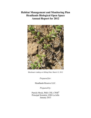
  • 1. Habitat Management and Monitoring Plan Headlands Biological Open Space Annual Report for 2012 Blochman’s dudleya in Hilltop Park, March 12, 2012 Prepared for: Headlands Reserve LLC. Prepared by: Patrick Mock, PhD, CSE, CWB® Principal Scientist, URS La Jolla January 2013
  • 2. TABLE OF CONTENTS 22-Mar-13SDG i Section 1 Summary of 2012 Activities............................................................................1-1 Section 2 Monitoring Status Reports.............................................................................2-1 2.1 Capital Improvements............................................................................................2-1 2.2 Construction Monitoring .......................................................................................2-2 2.3 Biotic Surveys........................................................................................................2-2 2.4 Biotic survey results ..............................................................................................2-3 2.5 Habitat Maintenance and Restoration....................................................................2-5 2.6 Public Service and General Maintenance ..............................................................2-6 2.7 Reporting ...............................................................................................................2-7 2.8 Endowment............................................................................................................2-8 Section 3 References Cited.............................................................................................3-1 Tables Table 1 California Gnatcatcher Monitoring Dates, Site Conditions, and Observations Table 2 California Gnatcatcher Productivity 2007 through 2012 Figures Figure 1 California Gnatcatcher Pairs Monitored During 2012 Breeding Season Dana Point Headlands Figure 2 Aerial Comparison Restoration Progress Dana Point Headlands Appendices Appendix A Animal Species Identified at the Dana Point Headlands Appendix B Plant Species Documented on the Dana Point Headlands
  • 3. SECTIONONE Summary of 2012 Activities 22-Mar-13SDG 1-1 SECTION 1 SUMMARY OF 2012 ACTIVITIES • Coastal California gnatcatcher (Polioptila californica californica) surveys were completed in 2012. A total of twelve coastal California gnatcatcher pairs were observed, and a total of 30 fledglings were detected during surveys. The twelve pairs are three greater than the nine pairs observed in 2011, and this is the highest recorded number of breeding pairs observed on the Headlands. The 30 fledglings that were detected in 2012 are 2 more than were detected in 2011. • No coastal cactus wrens (Campylorhynchus brunnecapillus sandiegensis) were observed on site in 2012. • The Center for Natural Lands Management, owner and manager of the Headlands Conservation Park, conducted a Pacific pocket mouse (Perognathus longimembris pacificus, PPM) trapping survey in 2012 on their property. A total of 57 individual PPM were captured and 47 were released. The remaining 10 individuals were delivered to the captive breeding program at the San Diego Zoo’s Wild Animal Park. These 10 individuals consisted of 3 adult males, 3 adult females, 2 juvenile males, and 2 juvenile females. Both the 2012 trapping survey and the 2011 track recording results show that the pocket mouse locations are distributed on both sides of the former Marguerita Avenue. • Nature’s Image, the restoration landscape contractor, continues to provide maintenance of the restored habitat areas subject to the monitoring and recommendations of URS Corporation. The majority of the restoration area has progressed beyond the established success criteria, and is no longer maintained. The only areas where maintenance continued in 2012 are the former Marguerita Road and the waterline easement. Non-native plant species are continuing to be removed and the habitat restoration that was implemented within these areas continued in 2012. The annual report (URS 2012) for the Dana Point Headlands (DPH) re-vegetation program has been prepared for submittal to the City of Dana Point. Overall, native cover for Marguerita Road is 69.6% and on the waterline easement 60.3%. Non-native cover is under the 10 percent performance standard threshold; Marguerita Road is 1.0% and the waterline easement is 0%. • In the Hilltop Park, Blochman’s dudleya (Dudleya blochmaniae ssp. blochmaniae) remained viable during 2012. The plantings were propagated from seeds collected at Hilltop Park in 2004 by Tony Bomkamp. In the later part of 2010, following the recommendation of Mr. Bomkamp, Headlands Reserve LLC contracted with Glenn Lukos Associates and Tree of Life to propagate and transplant the dudleya back into areas where it had previously been observed onsite. Several hundred dudleya were successfully propagated. In Spring of 2011, Mr. Bomkamp directed the installation of the plants by the restoration contractor back into the Hilltop Park. Damage to the initial plantings by rabbit herbivory was observed, so protective fencing of chicken wire was installed for a second group of plantings. The protective chicken wire remained in place throughout 2012. • The Headlands Nature Interpretive Center remained open throughout 2012. This facility, sited at the intersection of Scenic Drive and the former Marguerita Avenue, was completed and accepted by the City of Dana Point in December 2009 and the Headlands public trails in
  • 4. SECTIONONE Summary of 2012 Activities 22-Mar-13SDG 1-2 Hilltop Park, Harbor Point Park, and the Headlands Conservation Park were opened to the public by the City of Dana Point in early 2010. The Nature Interpretive Center includes an office for the City’s Natural Resources Protection Officer (NRPO), who oversees public awareness and protection of ecological resources within all of the Conservation Open Space Areas. In addition, trained volunteer docents assist in educating the public about the importance of the habitat areas, including those associated with tide pools. The Nature Interpretive Center includes public parking and serves as the trailhead for the Conservation Park trails and overlooks. The Nature Interpretive Center averages approximately 2,000 visitors per month, with approximately three times that number estimated to be using the Headlands trail system. Educational programs for school children were initiated in 2011. Signs along the trails direct visitors not to leave the fenced trails and that habitat restoration is in progress throughout the park areas. The ongoing presence of the City of Dana Point NRPO and docents encourages people to follow the trail rules. To protect sensitive species like the Pacific pocket mouse, gates allowing access into the Headlands Conservation Park are closed and locked each evening to prevent after hours usage. • No rare plant surveys were conducted in 2012 since surveys were previously completed in the spring seasons of 2009 (a dry year) and 2010 (a wet year). The Center for Natural Lands Management contracts separately for rare plant surveys within the Headlands Conservation Park. The findings associated with the 2009 and 2010 surveys were submitted in the Habitat Management and Monitoring Plan reports for those years (URS 2011, 2012). • At the end of 2009, Headlands Reserve LLC removed a 10-foot wide strip of decomposed granite (“DG”) from the surface of a 20-foot wide waterline easement that crosses a portion of Hilltop Park between Scenic Drive and Shoreline Drive. Following the removal of the DG, irrigation lines were extended to this easement area and coastal sage scrub seed and container plantings were installed to restore the native habitat in this area. That work commenced in 2009 with the planting, seeding, and irrigation being completed in January 2010. This area is being monitored by URS biologists for completion of the required restoration (See URS 2013). • Maintenance and monitoring of erosion control Best Management Practices (BMPs) and fencing is ongoing. .
  • 5. SECTIONTWO Monitoring Status Reports 22-Mar-13SDG 2-1 SECTION 2 MONITORING STATUS REPORTS The Dana Point Headlands Biological Open Space consists of 20.6 acres of natural open space preserve, now owned by the City of Dana Point following the City’s acceptance of improvements in December 2009. In addition, 29.4 acres of biological open space including the Headlands Conservation Park, is owned and managed by the Center for Natural Lands Management (CNLM). A habitat management and monitoring plan (HMMP) was prepared by URS Corporation (URS 2004) for all preserve lands associated with the Headlands development project, including the CNLM owned and managed Headlands Conservation Park. This document details the management activities for 2012 on the Dana Point Biological Open Space. Four primary management objectives for the Preserve are identified in the HMMP as presented below. These objectives are: 1. Maintain the Open Space to permit ecological processes to function. 2. Contribute to the preservation and restoration of the endangered or threatened species and their habitats that are present on the Biological Open Space. 3. Contribute to the preservation and restoration of non-listed sensitive species that contribute to biodiversity. 4. Develop a public awareness program that informs local residents and visitors of the sensitivity and ecological importance of the Preserve. The specific tasks that were to be undertaken to serve these objectives in 2012 were: 1. Monitor the behavior of any nesting coastal California gnatcatchers and coastal cactus wrens onsite, while also monitoring habitat restoration activities so they do not impact nesting pairs. 2. Oversee ongoing habitat restoration program in the former Marguerita Avenue and waterline easement, and provide recommendations to the restoration contractor. 3. Enhance restrictions and enforcement of controls for general public access, through use of patrols, fences and signs. 4. Coordinate management of the Headlands Conservation Park with the Center for Natural Lands Management and the City of Dana Point for the other Biological Open Space areas. The implementation of these tasks in 2012 is described below. They are organized within the following categories: 1) Capital Improvements, 2) Biotic Surveys, 3) Habitat Maintenance and Restoration, 4) Public Service and General Maintenance, 5) Reporting, and 6) Endowment. 2.1 CAPITAL IMPROVEMENTS Objective: Oversee habitat restoration and continuing maintenance of public use trail and protective fencing. In 2009, URS monitored the completion of the public trails and overlooks within the Harbor Point Park, Headlands Conservation Park and Hilltop Park. This work included the installation of permanent perimeter fencing, trail fencing and signage, and trash receptacles benches in the overlooks. No problems
  • 6. SECTIONTWO Monitoring Status Reports 22-Mar-13SDG 2-2 were encountered during the installation. The trails were opened to the public in January 2010. Marguerita Avenue pavement and public utilities were removed during July – September 2008 and the revegetation effort for that area began shortly thereafter in the fall of 2008. Following the completion of the permanent perimeter fencing, the construction fencing that was in place since 2005 was removed. The City of Dana Point has opened the Headlands Interpretive Center, which includes an office for the NRPO. The Center also includes public parking and serves as the trailhead for the Headlands Conservation Park. The Center provides educational information on the unique setting and habitat of the Dana Point Headlands. Signage at all the trailheads and along the trails has been installed to warn the public to stay within the fencing on marked trails and that sensitive habitat is currently being restored throughout the park areas. All of the public trails have been opened for use. Given the trail improvements, fencing, signage and related improvements were completed in 2009, no capital improvements were necessary for 2012. 2.2 CONSTRUCTION MONITORING Objective: Monitor for compliance with construction BMPs. • Project grading and construction of streets and infrastructure that adjoin conservation areas was completed in 2008 and prior. Completion of the public trails and the Interpretive Center occurred in 2009 within Hilltop Park, Harbor Point Park and Headlands Conservation Park. Monitoring for relevant construction activities was essentially completed in 2009. • The Headlands project remained in full compliance of conditions of approval for protection of biological resources. • Habitat fencing, silt fencing and other construction fencing have been maintained to protect conserved habitat areas. • Erosion control BMP measures have been maintained and are effective. 2.3 BIOTIC SURVEYS Objective: Conduct presence-absence surveys and nest monitoring of coastal California gnatcatcher and coastal cactus wren. The Dana Point Headlands population of coastal California gnatcatcher was monitored by URS Biologist Rick Bailey and CNLM Biologist Lee Ann Carranza. Mr. Bailey monitored the California gnatcatchers inhabiting the Hilltop Park, the Harbor Point Park, and the South Strand. Ms. Carranza monitored the gnatcatchers inhabiting the areas known as the Conservation Park West and Conservation Park East, located about 200 feet to the northeast side of former Marguerita Avenue, and continuing westward to the Headlands bluffs. This report includes the locations of adult gnatcatcher breeding pairs and the number of fledglings produced during 2012. Figure 1 shows gnatcatcher pair locations. The gnatcatcher pairs numbered 1 through 7 are located in the Conservation Park, with Pair 4 near the border between the Conservation Park and the Hilltop Park. Pairs 8 and 9 are located within the Hilltop Park, and Pairs 10 and 12 are located in the Harbor Point Park. Pair 11 is located within the Southern Strand, an area that had not been occupied by adult gnatcatchers prior to 2011. The survey dates and weather conditions during the URS surveys are shown in Table 1.
  • 7. SECTIONTWO Monitoring Status Reports 22-Mar-13SDG 2-3 2.4 BIOTIC SURVEY RESULTS Four of the five California gnatcatcher pairs nesting within the area monitored by Mr. Bailey successfully fledged young during the 2012 breeding season. A total of 12 fledglings were produced by these four gnatcatcher pairs. All seven of the pairs monitored by Ms. Carranza within the conservation Park successfully fledged young, with a total of 18 fledglings produced. The sum of 30 fledglings observed in 2012 is comparable with the 28 fledglings produced on-site in 2011. The number of fledglings observed during the surveys is given as a conservative estimate, as the fledglings were not closely approached. When the exact number of fledglings could not determined, a conservative count of at least the minimum number of fledglings present was recorded. Hence it is possible that more fledglings were produced than are recorded in this summary. The total number of fledglings are: two fledglings for Pair 1, three fledglings for Pair 2, four fledgling for Pair 3, two fledglings for Pair 4, three fledglings for Pair 5, three fledglings for Pair 6, one fledgling for Pair 7, three fledglings for Pair 8, four fledglings for Pair 9, two fledglings for Pair 10, three fledglings for Pair 11 and zero for Pair 12 (Figure 1). Table 2 below summarizes gnatcatcher productivity within the study area from 2007 through 2012, and includes potentially influential factors. The six-year average productivity for the Headlands site is 3.3 (± 0.52 SEM) fledglings per female per year, which is similar to other coastal areas where gnatcatcher productivity has be extensively monitored (Mock 2004) No cactus wrens were heard or seen onsite in 2012. Burrowing owl (Athene cunicularia hypugaea) individuals were observed in the Hilltop Park area on several occasions in November 2009 to March 2010. The burrowing owls were not seen onsite during the 2012 breeding season, but a burrowing owl was observed in the Hilltop and Conservation Parks in November 2010. Lists of plant and animal species documented within the Dana Point Headlands are included in Appendices A and B of this report. Table 1 California Gnatcatcher Monitoring Dates, Site Conditions, and Observations in 2012 Date Time Sky (%Clouds) Temp. (deg. F) Wind (mph) Personnel and Observations 3/12/2012 09:30-1400 70 - 20 55 - 63 2 - 5 R. Bailey & M. Jenkins observations during re-vegetation work: Pair 10 foraging in east end of habitat (male with full cap). Pair 11 foraging up near Dana Strand Road (male with full cap). 3/22/2012 15:40-18:40 60 63 2 – 3 R. Bailey: Two pairs (10 & 12) foraging near each other in east end of Harbor Point (both males with full cap). Pair 9 male with full cap seen briefly. 4/30/2012 16:30-19:00 100 63 - 60 1 R. Bailey: Pair 12 male foraging & vocalizing, then flew to east Conservation Park. Pair 10 foraging quietly. Pair 11 feeding 3 fledglings. 5/28/2012 08:40-12:40 0 60 - 75 2 – 4 R. Bailey & R. Randall: Pair 12 male vocalizing for 90 minutes. Pair 10 feeding 4 nestlings (about 2 days old). Pair 8 feeding 4 nestlings (about 12 days old). 6/4/2012 09:30-13:40 100 63 - 69 2 – 5 Pair 8 feeding 3 fledglings. Pair 9 feeding 3 older fledglings. Pair 10 feeding 4 nestlings. 6/11/2012 10:10-13:40 50 63 - 68 2 – 5 Pair 12 female foraging. Pair 10 feeding 1 fledgling (nest torn by predation attempt). Pair 11 nest building near
  • 8. SECTIONTWO Monitoring Status Reports 22-Mar-13SDG 2-4 Date Time Sky (%Clouds) Temp. (deg. F) Wind (mph) Personnel and Observations Dana Strand Road. 6/15/2012 M. Jenkins & J. Stout observation during re-vegetation work: Pair 8 still feeding 3 fledglings. Conservation Park pair feeding 3 fledglings near Visitor Center. 7/3/2012 10:10-14:30 100 62 - 70 3 – 5 R. Bailey & K. Riley: Pair 12 male vocalizing. Pair 10 feeding 2 fledglings. East Hilltop 3 fledglings seen (older/independent). Pair 11 second nest failed. 7/11/2012 12:00-15:40 100 72 - 74 2 – 4 R. Bailey & M. Jenkins: Pair 12 female foraging. Pair 10 foraging & chasing away juveniles. West Hilltop 3 independent juveniles foraging. Pair 9 foraging & chasing away juveniles. 7/17/2012 10:30-14:30 0 74 2 – 5 R. Bailey, R. Randall, & P. Howard: Pair 12 male seen along with independent juveniles. Pair 8 male seen along with independent juveniles. Pair 9 male seen along with independent juveniles. 7/24/2012 10:30-15:30 0 72 2 – 5 R. Bailey, R. Randall, & P. Howard: Pair 12 male seen along with independent juveniles. Pair 8 male seen along with independent juveniles. Pair 9 feeding 7 day old nestling (2 un-hatched eggs also in second nest). Pair 11 foraging. 8/3/2012 5:50-6:40 100 68 1 – 2 R. Bailey: Pair 9 feeding 1 fledgling. 8/5/2012 7:00-9:45 100 - 0 68 2 – 3 R. Bailey: West Harbor Point 2 juveniles foraging. Pair 10 foraging. West Hilltop 2 juveniles foraging. 8/11/2012 8:20-10:00 0 74 - 77 1 – 2 R. Bailey: Pair 10 and 2 juveniles foraging (male’s cap fading). 8/31/2012 6:45-10:10 0 70 -77 0 - 2 R. Bailey, R. Randall, & P. Howard: West Harbor Point 1 juvenile foraging. Pair 10 foraging (male’s cap mostly gone). Pair 8 foraging (male’s cap mostly gone). Pair 11 foraging near Dana Strand (male’s cap mostly gone). Juvenile pair foraging in lower South Strand. The Pacific pocket mouse population located in the Conservation Park is monitored by the Center for Natural Lands Management. Following the detection of an impressive 82 individual Pacific pocket mice during the 2009 survey, the CNLM determined that a focused survey was not necessary for 2010. The 2011 effort consisted of track recording tubes that monitored Pacific pocket mouse activity. In 2012 CNLM contracted a repeat of the 2009 trapping survey. A total of 57 individual PPM were captured and 47 were released. The remaining 10 individuals were delivered to the captive breeding program at the San Diego Zoo’s Wild Animal Park. These 10 individuals consisted of 3 adult males, 3 adult females, 2 juvenile males, and 2 juvenile females. Both the 2012 trapping survey and the 2011 track recording results show that the pocket mouse locations are distributed on both sides of the former Marguerita Avenue. No rare plant surveys were conducted in 2012, since surveys were previously completed in the spring seasons of 2009 (a dry year) and 2010 (a wet year). The Center for Natural Lands Management contracts
  • 9. SECTIONTWO Monitoring Status Reports 22-Mar-13SDG 2-5 separately for rare plant surveys within the Headlands Conservation Park. The findings associated with the 2009 and 2010 surveys were submitted in the Habitat Management and Monitoring Plan reports for those years (URS 2010, 2011). Table 2 California Gnatcatcher Productivity 2007 through 2012 Year Number of Breeding Pairs Fledglings Produced Average Fledglings Per Pair Potentially Influential Factors 2007 5 9 1.8 Low number of fledglings may be due to unfavorable weather conditions in 2007, including prolonged freezing temperatures in winter with record low rainfall for the year (less than 4 inches total). 2008 6 32 5.3 High number of fledglings likely due to more normal weather conditions and increased habitat value within the restoration areas. 2009 8 22 2.8 Moderate number of fledglings possibly due to lower success of first year breeding adult pairs. 2010 7 31 4.4 High number of fledglings likely due to increased growth in the restoration areas. The increased plant cover provides greater foraging and nesting resources. Also, Pair 5 produced three successful clutches by using the same nest from the prior year. This reduced nest building effort, as the same nest was used throughout the 2010 season. 2011 9 28 3.1 Moderate to high number of fledglings likely due to beneficial weather conditions and increased habitat value within the restoration areas. 2012 12 30 2.5 High number of total fledglings likely due to beneficial weather conditions and increased habitat value within the restoration areas. The increase in number of breeding pairs did not create a proportionately large increase in fledglings due to lower per pair nest success, possibly due to higher predation rates, reduced territory sizes, and more frequent territorial boundary disputes. The first year adult pairs may also have had lower nest success due to lack of breeding experience. 2.5 HABITAT MAINTENANCE AND RESTORATION Objective 1: Oversee habitat restoration program. The habitat restoration program continues to achieve positive results for the Headlands Biological Open Space and associated sensitive species. As most areas of the Headlands Biological Open Space met and exceeded program goals in 2011, only the former Marguerita Avenue and the waterline easement required further monitioring and reporting in 2012. Transect data at these locations were collected at the Headlands by URS biologists Mitch Jenkins and Julie Stout in June 2012. The transect locations were randomly established during the original baseline data collection effort conducted in October 2005.
  • 10. SECTIONTWO Monitoring Status Reports 22-Mar-13SDG 2-6 Transects are located within “enhancement” areas of previously existing degraded native habitat, as well as in “creation” areas where no existing native habitat was present. An extensive analysis of the quantitative transect data is presented in the Annual Re-vegetation Monitoring Report (URS 2013). Overall, native cover for Marguerita Road is 69.6% and on the waterline easement 60.3%. Non-native cover is under the 10 percent performance standard threshold; Marguerita Road is 1.0% and the waterline easement is 0%. Overall, the biological open space areas appear to be fully vegetated compared to the 2006 condition (Figure 2). Recommendations are listed below: • Continue ongoing weed removal during routine maintenance visits to ensure the continued control of exotic species to allow native vegetation to mature with minimal competition for resources such as water, nutrients, and light. • Irrigation was turned off in 2011 for the Marguerita Avenue area to assess the potential of this area to survive for one season without supplemental irrigation. The Marguerita Avenue percent cover was above the 50% standard. This area has completed four years of grow-in, and maintained a low percentage of non-native species. Based on these results, the irrigation should remain off during 2013, and continued positive results are expected. Objective 3: Conduct weed control outside of the active restoration areas, as needed. Nature’s Image, the restoration contractor, regularly pulls re-sprouting and newly germinating weedy plants encountered during habitat maintenance activities. 2.6 PUBLIC SERVICE AND GENERAL MAINTENANCE Objective 1: Enhance restrictions and enforcement over general public access, through use of patrols, fences and signs. The measures taken in 2010 continued throughout 2011 and 2012. The Biological Open Space has been permanently fenced to prevent unauthorized public access along perimeter streets, trails, and property lines. Signage has been installed along all trailheads, fences, streets, and trails informing the public to enter the parks at trailheads only, to stay on the trails, and to obey the rules and regulations for the parks, including the stipulation that dogs are not allowed. The signage also informs visitors that sensitive habitat is present and is being restored. These areas are monitored to minimize unauthorized access and repairs to fencing and gates are made when required. Trash receptacles have been installed at the trailheads and at the overlooks. Maintenance also includes the removal of trash that either blows into the site or is thrown over the fences. At certain points along the beach access trail within the South Strand restoration area, some trail users apparently were climbing over the fences between switchbacks on the trail, resulting in minor damage to the revegetaton effort. To discourage such activity, additional Coastal prickly pear and Coast cholla cactus were planted where the fences had been climbed. The vegetation at the switchbacks appears to have now recovered and the issue of trespassing off the trails appears to have been abated by the cactus as hoped.
  • 11. SECTIONTWO Monitoring Status Reports 22-Mar-13SDG 2-7 Objective 2: Develop a public awareness program that informs local residents and visitors of the sensitivity and ecological importance of the Preserve. The trails within the Biological Open Space are now open to the public. Signage for public awareness and resource management has been coordinated with the City of Dana Point and is installed as referenced above. In addition, biotic and related interpretive information is available at the Headlands Nature Interpretive Center, completed in 2009. The City of Dana Point employs a NRPO to focus on public awareness and protection of ecological resources within all of the Conservation Open Space Areas. The NRPO has trained volunteer docents to assist in educating the public about the importance of the habitat areas, including those associated with tide pools. Since its opening in early 2010, the Headlands Nature Interpretive Center has an average of some 2,000 visitors a month and as many as three times that many visitors to the nearby trail system. The City prepared an outreach brochure for visitors which became available in early 2011. Also, an educational program for school children was initiated in 2011. In addition, CNLM provides routine oversight and monitoring of the Headlands Conservation Park, signage and focused management for the area under their ownership. URS prepared an informational poster concerning the Headlands Habitat Restoration that was presented at the 2009 Annual Meeting of the Wildlife Society in Monterey, CA. A modified version of this poster is on display at the Headlands Nature Interpretive Center. 2.7 REPORTING Objective: Draft a Five Year Management Plan, an Annual Report, and a Work Plan. The recommendations in this report are designed to enhance the natural habitat and rare species populations within the conservation area. The onsite population of adult breeding California gnatcatcher pairs was greater in 2009, 2011, and 2012 than in any year previously recorded, although the adult population did return to previous levels in 2010. The production of California gnatcatcher fledglings on the site has also increased. Likewise, the CNLM reported record numbers of Pacific pocket mouse inhabiting the Conservation Park West in 2009. In 2012, a total of 57 individual PPM were captured and 47 were released. The remaining 10 individuals were delivered to the captive breeding program at the San Diego Zoo’s Wild Animal Park. These 10 individuals consisted of 3 adult males, 3 adult females, 2 juvenile males, and 2 juvenile females. Both the 2012 trapping survey and the 2011 track recording results show that the pocket mouse locations are distributed on both sides of the former Marguerita Avenue. A 50 percent vegetative cover goal within the Marguerita Avenue restoration area has been established to benefit the Pacific pocket mouse. A letter from USFWS further discussing the benefits of the reduced cover in this particular area is included in the Annual Revegetation Monitoring Report (URS 2011). No changes to the management recommendations in the above sections of this report for 2012 are recommended at this time. The five year Headlands Management and Monitoring Plan was written and adopted in 2005 and is due to be reviewed and updated to cover the next five year period. URS will be coordinating this review with the City of Dana Point, Headlands Reserve LLC and the Center for Natural Lands Management.
  • 12. SECTIONTWO Monitoring Status Reports 22-Mar-13SDG 2-8 2.8 ENDOWMENT Headlands Reserve LLC is required by its conditions of approval and the HMMP to establish, restore, and maintain the Habitat Restoration Areas for a period of at least five years to ensure its proper establishment and to meet the required restoration success criteria. The Headlands Development and Conservation Plan required the establishment of endowments for the permanent conservation of the sensitive biological open space of the Headlands. CNLM manages the endowment for the land owned by CNLM. For the City owned Conservation Open Space, the developer (Headlands Reserve LLC) was required to provide a non- wasting endowment to the City of Dana Point sufficient to maintain the biological values of the open space. The amount of the endowment was initially set at $2,000,000. The final amount of the endowment shall be identified and documented by a public agency or non-profit entity experienced in the estimation of costs for open space management. The endowment requirement has been secured by a recorded $2,000,000 first deed of trust with the City of Dana Point as the sole beneficiary. Given that all of the current costs for ongoing habitat restoration, management, biological monitoring, fencing, invasive species removal and related expenditures are being funded directly by Headlands Reserve LLC, no expenditures of the $2.0 million endowment have occurred to date. The restoration planting for most areas onsite began in October 2006 and have completed the fifth year of grow-in. The Southern Strand area has completed its fifth year of grow-in. Marguerita Avenue has completed its fourth year of grow-in and the waterline easement area between Scenic Drive and Shoreline Drive has completed its third year of grow-in. Following the completion of the grow-in periods and achieving the required success criteria, the restoration areas will be turned over to the City of Dana Point for monitoring and maintenance.
  • 13. SECTIONTHREE References Cited 22-Mar-13SDG 3-1 SECTION 3 REFERENCES CITED Bomkamp, Tony, 2011. Glen Lukos Associates Botanist. Personal Communication with Kevin Darnall (Headlands LLC) and Patrick Mock (URS). March. Mock, P. 2004. California Gnatcatcher (Polioptila californica). In The Coastal Scrub and Chaparral Bird Conservation Plan: a strategy for protecting and managing coastal scrub and chaparral habitats and associated birds in California. California Partners in Flight. http://www.prbo.org/calpif/htmldocs/scrub.html URS Corporation, 2004. Habitat Management and Monitoring Plan For Dana Point Headlands Biological Open Space. Prepared for Headlands Reserve, LLC. April. URS Corporation, 2011. Final Report, Annual Re-vegetation Monitoring Report – 2010 The Headlands, Dana Point, California. Prepared for Headlands Reserve, LLC. March. URS Corporation, 2012. Final Report, Annual Re-vegetation Monitoring Report – 2011 The Headlands, Dana Point, California. Prepared for Headlands Reserve, LLC. January. URS Corporation, 2013. Final Report, Annual Re-vegetation Monitoring Report – 2012 The Headlands, Dana Point, California. Prepared for Headlands Reserve, LLC. January. .
  • 15. "/ "/ "/ "/ "/ "/ "/ "/ "/ "/ "/ "/ HILLTOP PARK HEADLANDS CONSERVATION PARK SOUTH STRAND OPEN-SPACE HARBOR POINT PARK GREEN LANTERN SCENIC DRIVE M ARG UERITA AVE Pair 10 Pair 9 Pair 6 Pair 4 Pair 3 Pair 5 Pair 2 Pair 1 Pair 11 Pair 12 Pair 7 Pair 8 Path:G:gisprojects157727644335mxd2013cagn_mayjune2012.mxd,Colin_Mattison,1/29/2013,9:19:44AM SOURCES: URS (CAGN survey 2010). Keith Co. (Project Boundary, Nov 2004). CCC (Proposed ESHA Boundary). 2012 Aerial (LENSKA). CALIFORNIA GNATCATCHER PAIRS MONITORED DURING 2012 BREADING SEASON DANA POINT HEADLANDS CREATED BY: CM PM: PM PROJ. NO: 27644335.14000 FIG. NO: 1SCALE: 1" = 200' (1:2,400) 100 0 100 200 Feet O SCALE CORRECT WHEN PRINTED AT 11X17 LEGEND "/ California Gnatcatcher Location Biological Open Space Boundary Between Hilltop Park and Headlands Conservation Park Project Boundary DATE: 1/29/2013
  • 16. Path:G:gisprojects157727644335mxdaerial_comparison_2012.mxd,Colin_Mattison,1/28/2013,2:57:55PM SOURCES: Kieth Co. (Project Boundary, Nov 2004). 2006 Aerial (Lenska). 2012 Aerial (Aerials Express). AERIAL COMPARISON RESTORATION PROGRESS DANA POINT HEADLANDS CREATED BY: PM PM: PM PROJ. NO: 27644335.14000 DATE: 1/28/2013 FIG. NO: 2SCALE: 1" = 350' (1:4,200) 175 0 175 350 Feet O SCALE CORRECT WHEN PRINTED AT 11X17 LEGEND Project Boundary Biological Open Space January 2006 May/June 2012
  • 17. APPENDIXA Animal Species Identified at the Dana Point Headlands 22-Mar-13SDG
  • 18. APPENDIXA Animal Species Identified at the Dana Point Headlands 22-Mar-13SDG A-1 Scientific Name Common Name AMPHIBIANS Hyla regilla Pacific treefrog REPTILES Cnemidophorus hyperythrus Orange-throated whiptail Elgaria multicarinatus Southern alligator lizard Eumeces skiltonianus Western skink Lampropeltis getula californiae California kingsnake Masticophis flagellum piceus Red racer, Coachwhip Sceloporus occidentalis Western fence lizard Uta stansburiana Side-blotched lizard BIRDS Aeronautes saxatalis White-throated swift Agelaius phoeniceus Red-winged blackbird Aphriza virgata Surfbird Ardea herodias Great blue heron Arenaria melanocephala Black turnstone Athene cunicularia Burrowing owl (observed in winter of 2009 & 2010) Buteo jamaicensis Red-tailed hawk Butorides striatus Green heron Calidris alba Sanderling Callipepla californica California quail Calypte anna Anna’s hummingbird Calypte costae Costa’s hummingbird Campylorhynchus brunneicapillus cousei Coastal cactus wren (not observed since early 1990’s) Carduelis psaltria Lesser goldfinch Carpodacus mexicanus House finch Cathartes aura Turkey vulture Catharus guttatus Hermit thrush Catoptrophorus semipalmatus Willet Chamaea fasciata Wrentit Colaptes auratus Northern flicker Columba livia Rock dove (feral pigeon) Contopus sordidulus Western wood peewee
  • 19. APPENDIXA Animal Species Identified at the Dana Point Headlands 22-Mar-13SDG A-2 Scientific Name Common Name Corvus brachyrhynchos American crow Corvus corax Common raven Dendroica coronata Yellow-rumped warbler Dendroica nigrescens Black-throated gray warbler Dendroica occidentalis Hermit warbler Dendroica townsendii Townsend’s warbler Elanus leucurus White-tailed kite Empidonax difficilis Pacific-slope flycatcher Empidonax hammondii Hammond’s flycatcher Euphagus cyanocephalus Brewer’s blackbird Falco columbarius Merlin Falco peregrinus Peregrine falcon Falco sparverius American kestrel Geococcyx californianus Greater roadrunner Geothlypis trichas Common yellowthroat Hirundo rustica Barn swallow Icterus bullockii Bullock’s oriole Icterus galbula Northern oriole Lanius ludovicianus Loggerhead shrike Larus californicus California gull Larus delawarensis Ring-billed gull Larus glaucescens Glaucous-winged gull Larus heermanni Heermann’s gull Larus occidentalis Western gull Limosa fedoa Marbled godwit Melospiza lincolnii Lincoln’s sparrow Melospiza melodia Song sparrow Mimus polyglottos Northern mockingbird Molothrus ater Brown-headed cowbird Myiarchus cinerascens Ash-throated flycatcher Numenius phaeopus Whimbrel Oporornis tolmiei MacGillivray’s warbler Pelecanus occidentalis Brown pelican Phalacrocorax auritus Double-crested cormorant Phalacrocorax pelagicus Pelagic cormorant
  • 20. APPENDIXA Animal Species Identified at the Dana Point Headlands 22-Mar-13SDG A-3 Scientific Name Common Name Pheucticus melanocephalus Black-headed grosbeak Picoides nuttallii Nuttall’s woodpecker Pipilo crissalis California towhee Pipilo erythrophthalmus Spotted towhee Pluvialis squatarola Black-bellied plover Polioptila californica californica Coastal California gnatcatcher Psaltriparus minimu Bushtit Regulus calendula Ruby-crowned kinglet Sayornis nigricans Black pheobe Sayornis saya Say’s phoebe Selasphorus rufus Rufous hummingbird Selasphorus sasin Allen’s hummingbird Sialia mexicana Western bluebird Spizella passerine Chipping sparrow Stelgidopteryx serripennis Northern rough-winged swallow Sterna caspia Caspian tern Sturnella neglecta Western meadowlark Sturnus vulgaris European starling Thryomanes bewickii Bewick’s wren Toxostoma redivivum California thrasher Troglodytes aedon House wren Tyrannus verticalis Western kingbird Tyrannus vociferans Cassin’s kingbird Vermivora celata Orange-crowned warbler Vermivora ruficapilla Nashville warbler Wilsonia pusilla Wilson’s warbler Zenaida macroura Mourning dove Zonotrichia albicollis White-throated sparrow Zonotrichia atricapilla Golden-crowned sparrow Zonotrichia leucophrys White-crowned sparrow MAMMALS Lynx rufus Bobcat Microtus californicus California vole Mus musculus House mouse Neotoma lepida Desert woodrat
  • 21. APPENDIXA Animal Species Identified at the Dana Point Headlands 22-Mar-13SDG A-4 Scientific Name Common Name Perognathus longimembris pacificus Pacific pocket mouse Peromyscus californicus California mouse Peromyscus eremicus Cactus mouse Peromyscus maniculatus Deer mouse Phoca vitulina Harbor seal (offshore) Reithrodontomys megalotis Western harvest mouse Spermophilus beecheyi California ground squirrel Sylvilagus audubonii Desert cottontail Zalophus californianus California sea lion (offshore) **Amphibian, reptile, bird, and mammal nomenclature follows Laudenslayer et al., 1991.
  • 22. APPENDIXB Plant Species Documented at the Dana Point Headlands 22-Mar-13SDG
  • 23. APPENDIXB Plant Species Documented at the Dana Point Headlands 22-Mar-13SDG Scientific Name Common Name Polypodiaceae Polypody Fern Family Polypodium californicum California polypody+ Cupressaceae Cypress Family *Juniperus sp. Exotic planting Iridaceae Iris Family Sisyrinchium bellum Blue-eyed grass JUNCACEAE Rush Family Juncus bufonius Toad-rush LILIACEAE Lily Family *Agave americana American agave *Agave attenuat Dyck *Asparagus officinalis Wild asparagus Bloomeria crocea Common goldenstars Calochortus splendens Splendid mariposa-lily Chlorogalum parviflorum Small-flower soapplant Dichelostemma capitatum Wild hyacinth Pinaceae Pine Family *Pinus sp. Exotic planting Poaceae Grass Family *Avena barbata Slender wild oat *Bromus diandrus Ripgut brome *Bromus hordaceous Soft chess *Bromus madritensis Foxtail chess *Cynodon dactylon Bermuda grass Distichlis spicata Salt grass+ *Gastridium ventricosum Nitgrass Hordeum intercedens Vernal barley *Hordeum murinum Hare barley *Lolium perrene English ryegrass Melica imperfecta Coast range melic Muhlenbergia microsperma Little-seed muhly Nassella (Stipa) lepida Foothill needlegrass Nassella (Stipa) pulchra Purple needlegrass *Phalaris canariensis Mediterranean canarygrass *Piptatherum milliaceum Smilo grass
  • 24. APPENDIXB Plant Species Documented at the Dana Point Headlands 22-Mar-13SDG Scientific Name Common Name *Poa annua Annual bluegrass *Polypogon monspeliensis Annual beardgrass *Schismus barbatus Mediterranean schismus *Vulpia myuros Foxtail fescue Typhaceae Cat-tail Family Typha latifolia Soft flag Aizoaceae Carpet-weed Family *Carpobrotus edulis Hottentot *Mesembryanthemum crystallinum Crystal ice plant *Mesembryanthemum nodiflorum Little ice plant *Tetragonia tetragonioides New Zealand spinach Amaryllidaceae Amaryllis Family *Narcissus papyraceus Paperwhites Anacardiaceae Sumac Family Rhus integrifolia Lemonadeberry Apiaceae Carrot Family Apiastrum angustifolium Wild celery *Daucus carota Wild carrot Daucus pusillus Rattlesnake weed+ *Foeniculum vulgare Fennel Sanicula arguta Sharp-tooth sanicle Apocynaceae Dogbane Family *Nerium oleander Oleander *Vinca major Blue periwinkle Asteraceae Aster Family Amblyopappus pusillus Coast weed+ Ambrosia psilostachya Western ragweed Artemisia californica California sagebrush Artemisia palmeri San Diego sagewort (2010) Baccharis pilularis Coyote brush Baccharis salicifolia Mulefat *Centaurea melitensis Tocalote Chaenactis glabriuscula San Diego pincushion Chaenactis glabriuscula var. orcuttiana Orcutt’s pin cushion (2010 - further study needed to confirm) *Chamomilla suaveolens Pineapple weed
  • 25. APPENDIXB Plant Species Documented at the Dana Point Headlands 22-Mar-13SDG Scientific Name Common Name *Chrysanthemum coronarium Garland chrysanthemum *Cirsium vulgare Bull thistle *Conyza canadensis Horseweed *Coreopsis gigantean Giant sea dahlia *Cynara cardunculus Artichoke thistle/cardoon Encelia californica Common encelia Erigeron foliosus foliosus (stenophyllus) Leaf daisy Filago californica California filago *Filago gallica Narrow-leaved filago+ Gnaphalium bicolor Cudweed Gnaphalium californicum California everlasting Gnaphalium chilense Gnaphalium canescens White everlasting Grindelia camporum var.bracteosum Green gum plant *Hedypnois cretica Crete hedypnois Hemizonia fasciculata Tarweed Heterotheca grandiflora Telegraph weed *Hypochaeris glabra Cat's ear Isocoma menziesii Coastal goldenbush Lasthenia californica Goldfields Lessingia filaginifolia filaginifolia Virgate sand aster Layia platyglossa Common tidy tips+ Malacothrix saxatilis tenuifolia Cliff malacothrix Microseris douglasii ssp. platycarpha Small-flowered microseris (2010) Osmadenia tenella Rosinweed Pentachaeta aurea Golden daisy Senecio californicus California butterweed *Sonchus asper Spiny-leaf sow-thistle *Sonchus oleraceus Common sow-thistle Stephanomeria diegensis San Diego wreath plant Stylocline gnaphalioides Everlasting nest straw Uropappus lindleyi Silver puffs Boraginaceae Borage Family Amsinckia menziesii intermedia Rancher's fiddleneck
  • 26. APPENDIXB Plant Species Documented at the Dana Point Headlands 22-Mar-13SDG Scientific Name Common Name Cryptantha intermedia Nievitas *Echium plantagineum Plagiobothrys collinus californicus California popcornflower Plagiobothrys collinus gracilis Small California popcorn flower BRASSICACEAE Mustard Family *Brassica nigra Black mustard *Cakile maritima maritima Sea-rocket *Hirshfeldia incana Short-pod mustard Lepidium lasiocarpum Sand peppergrass Lepidium nitidum Peppergrass *Lobularia maritima Sweet alyssum *Sisymbrium irio London rocket CACTACEAE - Cactus Family Opuntia littoralis Coastal prickly pear Opuntia oricola Oracle cactus Opuntia prolifera Coast cholla CAPPARACEAE Caper Family Isomeris arborea Bladderpod CARYOPHYLLACEAE Pink Family Cardionema ramosissima Tread lightly Polycarpon depressum California polycarp *Polycarpon tetraphyllum Four-leaf polycarp *Silene gallica Common catchfly *Spergularia villosa Villous sand spurry CHENOPODIACEAE Goosefoot Family Aphanisma blitoides Aphanisima+ Atriplex breweri Brewer's saltbush Atriplex californica California saltbush Atriplex coulteri Coulter’s saltbush Atriplex watsonii Watson saltbush Atriplex leucophylla Seaside saltbush Chenopodium murale Nettle-leaf goosefoot *Salsola tragus (iberica) Russian thistle Suaeda taxifolia Woolly sea blite
  • 27. APPENDIXB Plant Species Documented at the Dana Point Headlands 22-Mar-13SDG Scientific Name Common Name CONVOLVULACEAE Morning-Glory Family Calystegia macrostegia Morning glory Dichondra occidentalis Western dichondra CRASSULACEAE - Stonecrop Family *Crassula argentea Exotic planting Crassula connata connata Dwarf stonecrop Dudleya blochmaniae ssp. blochmaniae Blochman’s dudleya Dudleya caespitosa Sea lettuce Dudleya lanceolata Coastal dudleya Dudleya pulverulenta Chalk dudleya CUCURBITACEAE Gourd Family Marah macrocarpus Wild cucumber EUPHORBIACEAE Spurge Family Croton californicus California croton Euphorbia misera Cliff spurge *Euphorbia peplus Petty spurge *Ricinus communis Castor bean FABACEAE - Pea Family *Acacia sp. Exotic planting *Bauhinia sp. Exotic planting Lotus scoparius Deerweed Lotus strigosus Bishop's lotus Lupinus truncates Collar lupine *Medicago polymorpha California bur clover *Melilotus indicus Indian sweet clover GERANIACEAE Geranium Family *Erodium botrys Long-beak filaree *Erodium cicutarium Red-stem filaree Erodium macrophyllum Large-leaf filaree *Pelargonium zonale Zonal geranium HYDROPHYLLACEAE Waterleaf Family Phacelia distans Wild heliotrope HYPERICACEAE St. John's Wort Family Hypericum canariense Canary Island's St.John's wort
  • 28. APPENDIXB Plant Species Documented at the Dana Point Headlands 22-Mar-13SDG Scientific Name Common Name LAMIACEAE Mint Family *Marrubium vulgare Horehound Stachys ajugoides rigida Hedge nettle MALVACEAE Mallow Family *Hibiscus sp. Exotic planting *Lavatera assurgentiflora Malva rose *Malva parviflora Cheeseweed MUSACEAE Banana Family *Musa sp. Exotic planting MYOPORACEAE Myoporum Family *Myoporum laetum Myoporum NYTAGINACEAE Four O'Clock Family Mirabilis californica Wishbone bush ONAGRACEAE Evening Primrose Family Camissonia bistorta Southern sun cup Camissonia cheiranthifolia suffruticosa Beach evening primrose OXALIDACEAE Oxalis Family *Oxalis pes-caprae Bermuda buttercup+ PLANTAGINACEAE Plantain Family Plantago erecta California plantain Plantanus racemosa Western sycamore PLUMBAGINACEAE Leadwort Family Limonium californicum Sea lavender POLEMONIACEAE Phlox Family Linanthus dianthiflorus Ground pink POLYGONACEAE Buckwheat Family Chorizanthe procumbens Prostrate spine flower Chorizanthe staticoides Turkish rugging Eriogonum elongatum Tall buckwheat Eriogonum fasciculatum Flat-topped buckwheat Eriogonum gracile Slender buckwheat Eriogonum parvifolium Coastal buckwheat Pterostegia drymarioides Granny's hairnet *Rumex crispus Curly dock
  • 29. APPENDIXB Plant Species Documented at the Dana Point Headlands 22-Mar-13SDG Scientific Name Common Name PORTULACACEAE Purslane Family Calandrinia ciliata Red maids PRIMULACEAE Primrose Family *Anagallis arvensis Scarlet pimpernel ROSACEAE Rose Family *Raphiolepis indica Indian hawthorn RUBIACEAE Madder Family Galium angustifolium angustifolium Narrow-leaf bedstraw *Galium aparine Common bedstraw SAPINDACEAE Soap Berry Family *Dodonaea sp. Exotic planting SCROPHULARIACEAE Figwort Family Antirrhinum nuttallinum Nuttall's snapdragon Castilleja exserta Purple owl's clover Linaria canadensis Large blue toadflax Mimulus aurantiacus Monkeyflower Mimulus aurantiacus (puniceus) Red bush monkey flower SOLANACEAE Nightshade Family Datura wrightii Western jimsonweed Lycium californicum Box thorn * next to genus name indicates a non-native plant species. All non-native plant species have been treated/removed by contractors of Headlands Reserve, LLC. However, they remain on this list to ensure they are retreated as necessary. + next to common name indicates species found on the CNLM Dana Point Preserve and added to this list by Eliza Maher (Center botanist) in her 2006 survey. Compiled from the "Habitat Management and Monitoring Plan For Dana Point Headlands Biological Open Space", by URS Corporation dated April 2004. However, the original list contained all plant species throughout the lands to be preserved associated with Headlands Reserve, LLC, and are not unique to only the portion of land that represents Biological Open Space.