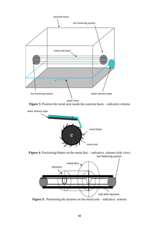
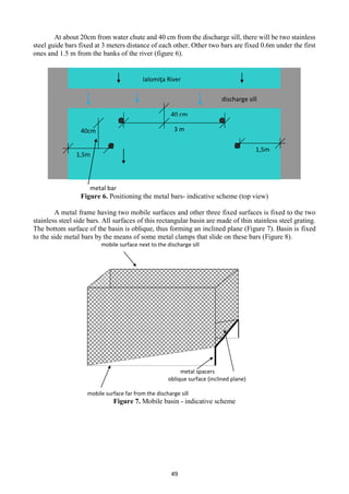
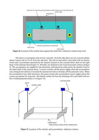
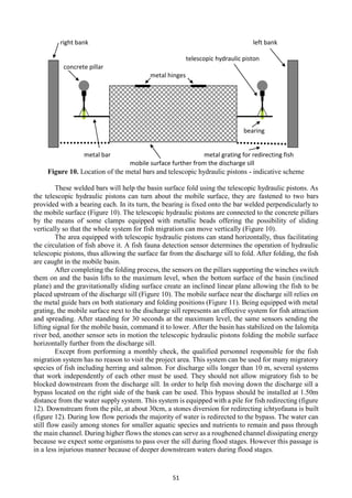
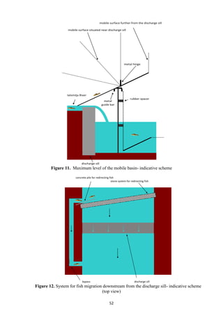
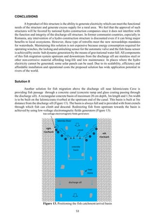
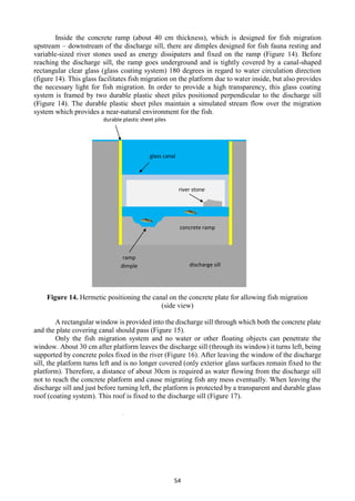
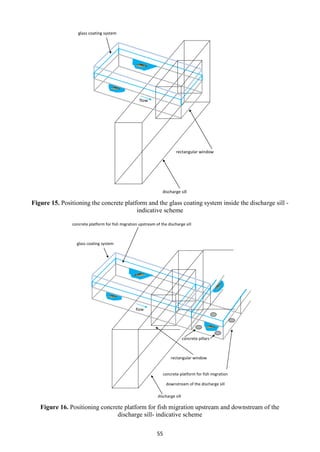
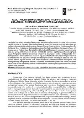
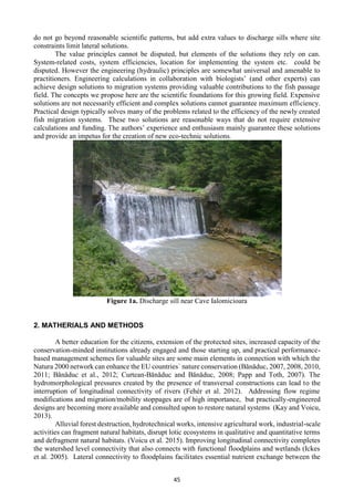
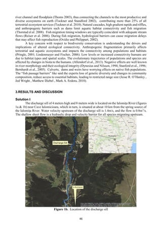
This document summarizes a proposed solution to facilitate fish migration above a discharge sill located on the Ialomița River near Cave Ialomicioara in Romania. The solution involves installing a pipe equipped with an automatic valve to divert a small amount of water from above the sill to below. A metal axle inside a concrete basin below would be attached to blades and a dynamo to generate electricity as water flows through the pipe. Guides bars and a movable basin above the sill would direct fish upstream using electric winches powered by the dynamo. The solution aims to restore connectivity while maintaining the sill's original purpose of flood dissipation with minimal costs and modifications.
The People’s Water Board is a coalition of labor, social justice, and environmental organizations based in Detroit. They work together to confront: 1) devastating lack of access to water faced by tens of thousands of low-income people who have had their water shut off; 2) water pollution due to aging wastewater infrastructure; and 3) the effort of corporate interests to gain control of Detroit’s water system. Listen to this panel discussion to learn about their struggles and victories.
https://waterpartnership.org.au/hydrogeology-of-the-dry-zone-central-myanmar-published/
https://waterpartnership.org.au/publications/
https://waterpartnership.org.au/wp-content/uploads/2017/10/Hydrogeology-of-the-Dry-Zone-Central-Myanmar-Summary.pdf
Hydrogeology of the Dry Zone, Central Myanmar
Hydrogeology of the Dry Zone – Central Myanmar, is a major study by Dr Leonard Drury, prepared with assistance from the Ministry of Agriculture, Livestock and Irrigation (MOALI). The study revises and updates hydrogeological surveys and a drilling program begun in the late 1970s to mid-1980s. It represents an understanding of the groundwater resources of the Dry Zone based on decades of experience from hydrogeologists from Myanmar and Dr Drury’s extensive international experience (read full summary).
Download Book: Hydrogeology of the Dry Zone, Central Myanmar 118mb
Acknowledgements
This report has been prepared by Dr Len Drury, Aqua Rock Konsultants, with assistance from the Groundwater Division, Irrigation
and Water Utilization Management Department (IWUMD) of the Ministry of Agriculture, Livestock and Irrigation (MOALI).
The figures and maps were digitised by International Centre Environmental Management (ICEM). The text was peer reviewed by
the International Water Management Institute (IWMI).
The author is grateful to colleagues (active and retired) from the Rural Water Supply Division (RWSD) of the Agricultural
Mechanisation Department (AMD) and IWUMD, other government departments, universities, city and township development
committees, Non-Government Organisations, and consulting companies who readily provided their hydrogeological reports
and databases. Special thanks to Deputy Director General U Tin Maung Aye Htoo, Director U Htay Lwin, and Assistant Director
U Than Zaw (IWUMD) whose professionalism and enthusiasm was outstanding; and U Myint Thein, Hydrogeological Advisor
to the National Water Resources Committee (NWRC) – Advisory Group, who facilitated meetings and gave valuable input.
Research Interests: Hydrogeology, Myanmar, Dry Zone, and central myanmar
StormWater Tree Trench - How does it work?Dai Quoc Tran
As mentioned in the preview section, urban area recently witnessed more and more negative impact from impermeable surfaces. Specifically, and in this case is stormwater
management, this phenomenon has historically been managed by expansive and capitalintensive underground storm sewer systems. This grey infrastructure has the single purpose to collect and carry runoff from city streets, parking lots, and other impervious
surfaces as quickly as possible. However, in the preceding pages, several of grey infrastructure‘s disadvantaged has been revealed and many potential merits from green infrastructure, in this case is stormwater tree trench has been introduced. Therefore, it is worth
bearing in mind that green infrastructure in general - stormwater tree trench in specific
must become our world ultimate aim for future city planning.
Presented by IWMI researcher, Marloes Mul, on the Re-optimization and reoperation study of the Akosombo and Kpong dams - Ghana, August 2015. Presented during a stakeholder a workshop held in Accra to explore the potential positive and negative impacts of changing flows.
Gray vs. Green: The Role of Watershed-scale Green Infrastructure Systems for ...Mcrpc Staff
Slides from a November 10, 2016 presentation to the Greenways Advisory Committee about green infrastructure, by Jim Patchett, Ron Doetch, and Raj Rajaram.
MAB-IHP Regional Symposium: Managing Water Resources in Biosphere Reserves in...UNESCO Venice Office
Gasper Hrastelj, Rosana Cerkvenik, Managing Water Resources in BRs in Slovenia
Venice, 16-17 December 2021
Overall responsibility for the views and opinions expressed in the slides is taken by the authors
Detailed description of Environmental Impact Assessment - Historical Background - Objectives - Assessment procedure - Necessity in Water resources projects - Environmental discourse on DAM construction - Case study
A Review of Environmental Implications of Dredging ActivitiesIJAEMSJORNAL
Dredging is a global anthropogenic excavation activity of removing sediments from water bodies and depositing it elsewhere. It is a mixed blessing as it has both beneficial and adverse impacts. This paper is on a review of environmental implications of dredging. The objective of the paper is to review previous works by researchers on the environmental consequences of dredging. The method used is a review of academic/journal articles, internet materials, conference / workshop papers, textbooks, bulletins and publicly available materials on dredging activities. The results of the study revealed that previous authors whose works were reviewed have a convergent view that apart from the beneficial impacts of dredging (e.g. keeping waterways navigable, flood and storm protection and provision of materials for road construction and building), it has lots of adverse environmental impacts, including environmental pollution, erosion, widespread hydrological changes, reduction in the population of aquatic lives like destruction of fish spawning grounds and benthic organisms and resuspension of particulate matter column that has elevated levels of lead, copper, zinc and nickel in Phytoplankton. Recommendations of the study include: (1) establishment of environmental legislations and regulations for dredging operation; (2) use of green technology in dredging activities to minimize suspension of sediments and contamination/pollution of dredging environments; and (3) creation of awareness among dredging contractors, regulators and marine communities where dredging take place on the economic and ecological values of the marine ecosystems that are usually very sensitive, fragile and productive.
Environment as important water use for hydro-infrastructure's considerationCPWF Mekong
By Chayanis Krittasudthacheewa, Stockholm Environment Institute
Presented at the Mekong Forum on Water, Food and Energy
Phnom Penh, Cambodia
December 7-9, 2011
Session 2b: Hydropower, Irrigation and Multiple-Use: Experiences from the Region
Similar to Fish passage system on Ialomița River!Lawrence G. Dominguez! (20)
Bio-Engineering Solutions for Restoring the PeŃa Creek, on the water sector...Răzvan Voicu
The issue of ecological restoration of water courses is a matter of public interest and has emerged as a consequence of human impact caused by the following factors:
industrialization, urbanization, agricultural and livestock activities, exploitation of
riverbeds materials, adjustment and embankment works etc.
The application of measures on restoring ecological status / potential of
deteriorated lotic systems, in accordance with W.F.D. (2000/60/EC) presents a
significant contribution to restoring functions (e.g. provisioning, regulating, supporting,
cultural) and implicitly services generated (ex. water quality) by the ecological systems
of natural capital.
2
The purpose of this paper is to propose solutions to renaturating the banks of the
PeŃa Creek, specifically in the river sector: PeŃa -> confluence to Hidisel creek –
discharging into the Crisul Repede River (L = 12.7 km) wich has been designated as
body of water heavily modified, in Crisuri River Area Management Plan. Considering
that this deteriorated sector has a moderate ecological potential, the objective is
restoring its ecological potential from moderate to good level in accordance with the
requirements of the WFD 2000/60 / EC.
In order to achieve its purpose in this paper, there was a detailed analysis of the
study area (documentation, field trips, analyzing data on biocenosis and water quality
and and data analysis to justify the designation of the body of water heavily modified)
and a river sector was selected in the unincorporated area of Oradea, Sânmartin
Village, Bihor County. This river sector has a length of 100 meters and has undergone
transformation as a result the regularization made in 1978.
Also, as mentioned above, the bio-engineering solutions proposed have local
character, and should be coupled with suitable m
Micro RNA genes and their likely influence in rice (Oryza sativa L.) dynamic ...Open Access Research Paper
Micro RNAs (miRNAs) are small non-coding RNAs molecules having approximately 18-25 nucleotides, they are present in both plants and animals genomes. MiRNAs have diverse spatial expression patterns and regulate various developmental metabolisms, stress responses and other physiological processes. The dynamic gene expression playing major roles in phenotypic differences in organisms are believed to be controlled by miRNAs. Mutations in regions of regulatory factors, such as miRNA genes or transcription factors (TF) necessitated by dynamic environmental factors or pathogen infections, have tremendous effects on structure and expression of genes. The resultant novel gene products presents potential explanations for constant evolving desirable traits that have long been bred using conventional means, biotechnology or genetic engineering. Rice grain quality, yield, disease tolerance, climate-resilience and palatability properties are not exceptional to miRN Asmutations effects. There are new insights courtesy of high-throughput sequencing and improved proteomic techniques that organisms’ complexity and adaptations are highly contributed by miRNAs containing regulatory networks. This article aims to expound on how rice miRNAs could be driving evolution of traits and highlight the latest miRNA research progress. Moreover, the review accentuates miRNAs grey areas to be addressed and gives recommendations for further studies.
UNDERSTANDING WHAT GREEN WASHING IS!.pdfJulietMogola
Many companies today use green washing to lure the public into thinking they are conserving the environment but in real sense they are doing more harm. There have been such several cases from very big companies here in Kenya and also globally. This ranges from various sectors from manufacturing and goes to consumer products. Educating people on greenwashing will enable people to make better choices based on their analysis and not on what they see on marketing sites.
Diabetes is a rapidly and serious health problem in Pakistan. This chronic condition is associated with serious long-term complications, including higher risk of heart disease and stroke. Aggressive treatment of hypertension and hyperlipideamia can result in a substantial reduction in cardiovascular events in patients with diabetes 1. Consequently pharmacist-led diabetes cardiovascular risk (DCVR) clinics have been established in both primary and secondary care sites in NHS Lothian during the past five years. An audit of the pharmaceutical care delivery at the clinics was conducted in order to evaluate practice and to standardize the pharmacists’ documentation of outcomes. Pharmaceutical care issues (PCI) and patient details were collected both prospectively and retrospectively from three DCVR clinics. The PCI`s were categorized according to a triangularised system consisting of multiple categories. These were ‘checks’, ‘changes’ (‘change in drug therapy process’ and ‘change in drug therapy’), ‘drug therapy problems’ and ‘quality assurance descriptors’ (‘timer perspective’ and ‘degree of change’). A verified medication assessment tool (MAT) for patients with chronic cardiovascular disease was applied to the patients from one of the clinics. The tool was used to quantify PCI`s and pharmacist actions that were centered on implementing or enforcing clinical guideline standards. A database was developed to be used as an assessment tool and to standardize the documentation of achievement of outcomes. Feedback on the audit of the pharmaceutical care delivery and the database was received from the DCVR clinic pharmacist at a focus group meeting.
"Understanding the Carbon Cycle: Processes, Human Impacts, and Strategies for...MMariSelvam4
The carbon cycle is a critical component of Earth's environmental system, governing the movement and transformation of carbon through various reservoirs, including the atmosphere, oceans, soil, and living organisms. This complex cycle involves several key processes such as photosynthesis, respiration, decomposition, and carbon sequestration, each contributing to the regulation of carbon levels on the planet.
Human activities, particularly fossil fuel combustion and deforestation, have significantly altered the natural carbon cycle, leading to increased atmospheric carbon dioxide concentrations and driving climate change. Understanding the intricacies of the carbon cycle is essential for assessing the impacts of these changes and developing effective mitigation strategies.
By studying the carbon cycle, scientists can identify carbon sources and sinks, measure carbon fluxes, and predict future trends. This knowledge is crucial for crafting policies aimed at reducing carbon emissions, enhancing carbon storage, and promoting sustainable practices. The carbon cycle's interplay with climate systems, ecosystems, and human activities underscores its importance in maintaining a stable and healthy planet.
In-depth exploration of the carbon cycle reveals the delicate balance required to sustain life and the urgent need to address anthropogenic influences. Through research, education, and policy, we can work towards restoring equilibrium in the carbon cycle and ensuring a sustainable future for generations to come.
WRI’s brand new “Food Service Playbook for Promoting Sustainable Food Choices” gives food service operators the very latest strategies for creating dining environments that empower consumers to choose sustainable, plant-rich dishes. This research builds off our first guide for food service, now with industry experience and insights from nearly 350 academic trials.
Willie Nelson Net Worth: A Journey Through Music, Movies, and Business Venturesgreendigital
Willie Nelson is a name that resonates within the world of music and entertainment. Known for his unique voice, and masterful guitar skills. and an extraordinary career spanning several decades. Nelson has become a legend in the country music scene. But, his influence extends far beyond the realm of music. with ventures in acting, writing, activism, and business. This comprehensive article delves into Willie Nelson net worth. exploring the various facets of his career that have contributed to his large fortune.
Follow us on: Pinterest
Introduction
Willie Nelson net worth is a testament to his enduring influence and success in many fields. Born on April 29, 1933, in Abbott, Texas. Nelson's journey from a humble beginning to becoming one of the most iconic figures in American music is nothing short of inspirational. His net worth, which estimated to be around $25 million as of 2024. reflects a career that is as diverse as it is prolific.
Early Life and Musical Beginnings
Humble Origins
Willie Hugh Nelson was born during the Great Depression. a time of significant economic hardship in the United States. Raised by his grandparents. Nelson found solace and inspiration in music from an early age. His grandmother taught him to play the guitar. setting the stage for what would become an illustrious career.
First Steps in Music
Nelson's initial foray into the music industry was fraught with challenges. He moved to Nashville, Tennessee, to pursue his dreams, but success did not come . Working as a songwriter, Nelson penned hits for other artists. which helped him gain a foothold in the competitive music scene. His songwriting skills contributed to his early earnings. laying the foundation for his net worth.
Rise to Stardom
Breakthrough Albums
The 1970s marked a turning point in Willie Nelson's career. His albums "Shotgun Willie" (1973), "Red Headed Stranger" (1975). and "Stardust" (1978) received critical acclaim and commercial success. These albums not only solidified his position in the country music genre. but also introduced his music to a broader audience. The success of these albums played a crucial role in boosting Willie Nelson net worth.
Iconic Songs
Willie Nelson net worth is also attributed to his extensive catalog of hit songs. Tracks like "Blue Eyes Crying in the Rain," "On the Road Again," and "Always on My Mind" have become timeless classics. These songs have not only earned Nelson large royalties but have also ensured his continued relevance in the music industry.
Acting and Film Career
Hollywood Ventures
In addition to his music career, Willie Nelson has also made a mark in Hollywood. His distinctive personality and on-screen presence have landed him roles in several films and television shows. Notable appearances include roles in "The Electric Horseman" (1979), "Honeysuckle Rose" (1980), and "Barbarosa" (1982). These acting gigs have added a significant amount to Willie Nelson net worth.
Television Appearances
Nelson's char
Natural farming @ Dr. Siddhartha S. Jena.pptxsidjena70
A brief about organic farming/ Natural farming/ Zero budget natural farming/ Subash Palekar Natural farming which keeps us and environment safe and healthy. Next gen Agricultural practices of chemical free farming.
Fish passage system on Ialomița River!Lawrence G. Dominguez!
1. 44
Annals of Valahia University of Targoviste. Geographical Series (2016), 16(2): 44-58
DOI: 10.1515/avutgs-2016-0004
ISSN (Print): 2393-1485, ISSN (Online): 2393-1493
FACILITATION FISH MIGRATION ABOVE THE DISCHARGE SILL
LOCATED ON THE IALOMIŢA RIVER NEAR CAVE IALOMICIOARA
Răzvan Voicu1
, Lawrence G. Dominguez2
1
National Institute of Hydrology and Water Management, Sos. Bucuresti-Ploiesti 97, Bucuresti,
cod013686, Romania, Tel.:+40-21-3181115, Email: rzvnvoicu@yahoo.com
2
Washington Department of Fish and Wildlife, Fish Passage Division, (United States) Natural
Resources Building 1111 Washington St. SE Olympia, WA 98501,
tel: 360-902-200, Lawrence.Dominguez@dfw.wa.gov
Abstract
Longitudinal connectivity restoration of watercourses is a major duty for scientists (biologists, hydro engineers,
chemists etc.) that, by the means of technical exchange via conferences, projects, workshops, universities, and
institutions demonstrate the major importance of a natural (non-anthropic) function of the lotic ecosystems. On
the Ialomiţa River, the discharge sills located downstream from Padina chalet block the migration of some fish
species, such as the brown trout (Salmo trutta) and the bullhead (Cottus gobio), prohibiting access to foraging
areas and springs. Water Framework Directive 60/2000 / EC provides a legal framework for restoring “good
status” of longitudinal and lateral connectivity of watercourses. Our proposed solution I can be applied to other
discharge sills and dams sized between 3m and 6m high, and, where feasible can utilize existing power sources
of some discharge sills. Solution II’s concepts allow the dimples inside the concrete plate to serve as a rest and
recovery area for migratory species. Such benefits that ensure upstream/downstream fish migration while
allowing discharge management to continue is unattainable in conventional systems. After solution II is applied
the discharge sill does not lose any baseline characteristics while maintaining the original hydro-technical design
objective, flood dissipation.
Keywords: fish migration, ecobiome’s functionality, Ialomiţa River, longitudinal connectivity, dam.
1.INTRODUCTION
Conservation of the valuable National Park Bucegi avifauna sites necessitates a great
coordination of the policy makers, including NGOs, the scientists and volunteers. Unfettered
development within the Bucegi Mountains remains the greatest threat to protect and preserve these
ecological treasures. Free migration of fish in the study area and watershed area in general, represents
an important element of the optimal functioning local ecosystems. Construction across stream
channels (discharge sills) partition Brown trout, bullhead and the endangered Golden trout habitats.
Lack of exchange through habitats drastically reduce productivity and capacity of these species. This
paper describes some engineering solutions that help fish overcome these obstacles. Fish migration
systems over discharge sills and dams can't be achieved only by relying on gravitational flows of
water due to hydraulic drops and velocities that exceed these species swim performance. Structure
designers must take into account other parameters such as hydraulic and mechanical energy, channel
roughness, traction, and redirection systems. Below we present a crossing solution over the discharge
sill in the Ialomiţa River, near Cave Ialomicioara.(Figures 1a and 1b).
Like any field conception, design and construction of fish migration systems across different
transversal hydraulic structures is continuously improving. Therefore new relevant and achievable
ideas are welcome, and time will demonstrate their effectiveness. Solution I and Solution II concepts
2. 45
do not go beyond reasonable scientific patterns, but add extra values to discharge sills where site
constraints limit lateral solutions.
The value principles cannot be disputed, but elements of the solutions they rely on can.
System-related costs, system efficiencies, location for implementing the system etc. could be
disputed. However the engineering (hydraulic) principles are somewhat universal and amenable to
practitioners. Engineering calculations in collaboration with biologists’ (and other experts) can
achieve design solutions to migration systems providing valuable contributions to the fish passage
field. The concepts we propose here are the scientific foundations for this growing field. Expensive
solutions are not necessarily efficient and complex solutions cannot guarantee maximum efficiency.
Practical design typically solves many of the problems related to the efficiency of the newly created
fish migration systems. These two solutions are reasonable ways that do not require extensive
calculations and funding. The authors’ experience and enthusiasm mainly guarantee these solutions
and provide an impetus for the creation of new eco-technic solutions.
Figure 1a. Discharge sill near Cave Ialomicioara
2. MATHERIALS AND METHODS
A better education for the citizens, extension of the protected sites, increased capacity of the
conservation-minded institutions already engaged and those starting up, and practical performance-
based management schemes for valuable sites are some main elements in connection with which the
Natura 2000 network can enhance the EU countries᾽ nature conservation (Bănăduc, 2007, 2008, 2010,
2011; Bănăduc et al., 2012; Curtean-Bănăduc and Bănăduc, 2008; Papp and Toth, 2007). The
hydromorphological pressures created by the presence of transversal constructions can lead to the
interruption of longitudinal connectivity of rivers (Fehér et al. 2012). Addressing flow regime
modifications and migration/mobility stoppages are of high importance, but practically-engineered
designs are becoming more available and consulted upon to restore natural systems (Kay and Voicu,
2013).
Alluvial forest destruction, hydrotechnical works, intensive agricultural work, industrial-scale
activities can fragment natural habitats, disrupt lotic ecosystems in qualitative and quantitative terms
and defragment natural habitats. (Voicu et al. 2015). Improving longitudinal connectivity completes
the watershed level connectivity that also connects with functional floodplains and wetlands (Ickes
et al. 2005). Lateral connectivity to floodplains facilitates essential nutrient exchange between the
3. 46
river channel and floodplain (Thoms 2003), thus connecting the channels to the most productive and
diverse ecosystems on earth (Tockner and Standford 2002), contributing more than 25% of all
terrestrial ecosystem services (Tockner et al. 2010). Natural cascades, high gradient rapids and riffles,
and anthropogenic barriers such as dams limit aquatic habitat connectivity and fish migration
(Thorstad et al. 2008). Fish migration timing windows are typically coincident with adequate stream
flows (Reiser et al. 2006). During fish migration, hydrological barriers can cause migration delays
that may affect fish reproduction (Ovidio and Philippart, 2002).
A key concern with respect to biodiversity conservation is understanding the drivers and
implications of altered ecological connectivity. Anthropogenic fragmentation primarily affects
terrestrial and aquatic ecosystems and impacts the connectivity among populations and habitats
(Pringle, 2001; Lindenmayer and Fischer, 2006). Low levels or increased connectivity humans are
due to habitat types and spatial scales. The evolutionary trajectories of populations and species are
affected by changes in biota to the humans. (Allendorf et al., 2013). Negative effects are well known
in river morphology and their ecological integrity (Dynesius and Nilsson, 1994; Stanford et al., 1996;
Bernhardt et al., 2005). Culverts, dams and weirs have worrying effects on native fish populations.
The “fish passage barriers” like said the experts loss of genetic diversity and changes in community
composition, reduce access to essential habitats, leading to restricted range size (Jesse R. O’Hanley ,
Jed Wright , Matthew Diebel , Mark A. Fedora, 2010).
3.RESULTS AND DISCUSSION
Solution I
The discharge sill of 4 meters high and 8 meters wide is located on the Ialomiţa River (figures
1a & 1b) near Cave Ialomicioara, which in turn, is situated at about 10 km from the spring source of
the Ialomiţa River. Water velocity upstream of the discharge sill is 1.4m/s, and the flow is 0.8m3
/s.
The shallow sheet flow is a hydraulic drop and velocity barrier for all species migrating upstream.
Figure 1b. Location of the discharge sill
4. 47
On the right bank upstream of the discharge sill (at about 8m) a concrete water intake should
be built in order to fix a pipe equipped with an automatic valve which regulates the 6 l/s flow passing
through the pipe. The diameter of the pipe should be 10cm. The downstream end of the stainless steel
adduction pipe will be at 8 meters downstream of the discharge sill, on the right bank of the river.
The downstream end of the pipe is in a 1.5 m2
concrete basin (figure 2 - Detail shown in Figure 3) at
about 8 meters distance from the discharge sill. The difference in level between the upstream and
downstream ends of the pipe is 3m.
Figure 2. Positioning adduction pipe – indicative scheme (top view)
Inside the concrete basin a metal axle (bar) is fixed in concrete basin walls (figure 3) A disk
is welded to this metal axle. Some metal blades are welded to the metal disc (Figure 4) such that the
metal disc rotates due to the water in the pipe engaging the blades based on the mill principle. A
dynamo is fixed to the metal disc (Figure 5) that produces electricity. The water level in the concrete
canal is more than 20 cm lower than the bearings level and remains constant due to the pipe working
as an overflow (Figure. 3).
Ialomiţa River
right bank water intake left bank
concrete basin
water delivery pipe
automatic valve
discharge sill
adduction pipe
metal grille
5. 48
Figure 3. Position the metal axle inside the concrete basin – indicative scheme
Figure 4. Positioning blades on the metal disc – indicative scheme (side view)
Figure 5. Positioning the dynamo on the metal axle – indicative scheme
water level
concrete basin
bar fastening system
metal axle (bar)
bar fastening system water delivery pipe
water delivery pipe
metal blade
metal axle
bar fastening system
metal disc
dynamo
hub with dynamo
6. 49
At about 20cm from water chute and 40 cm from the discharge sill, there will be two stainless
steel guide bars fixed at 3 meters distance of each other. Other two bars are fixed 0.6m under the first
ones and 1.5 m from the banks of the river (figure 6).
Figure 6. Positioning the metal bars- indicative scheme (top view)
A metal frame having two mobile surfaces and other three fixed surfaces is fixed to the two
stainless steel side bars. All surfaces of this rectangular basin are made of thin stainless steel grating.
The bottom surface of the basin is oblique, thus forming an inclined plane (Figure 7). Basin is fixed
to the side metal bars by the means of some metal clamps that slide on these bars (Figure 8).
Figure 7. Mobile basin - indicative scheme
metal bar
40cm 3 m
1,5m
40 cm
1,5m
discharge sill
Ialomiţa River
mobile surface next to the discharge sill
metal spacers
oblique surface (inclined plane)
mobile surface far from the discharge sill
7. 50
Figure 8. Location of the mobile basin against the metal bars- indicative scheme (top view)
This basin is rectangular and swivels vertically. On both sides there are two concrete pillars
about 6 meters tall at 10 cm from the side bars. The end of each pillar is provided with an electric
winch and a accumulator powered by the dynamo located on the concrete basin shaft on the right
bank of the Ialomiţa River(Figure 9). Winches are fastened to the fixed horizontal surfaces (Figure
9). The accumulators are supplied to the maximum with electricity achieved by the dynamo fixed to
the metal shaft of the concrete basin. A sensor switches off the power supply when the accumulators
were charged and redirects it towards the national network or switches off the automatic valve. When
the accumulators have little electricity, the sensor restores the accumulators power supply and so the
system can operate for long time. The mobile surface far from the discharge sill is provided with two
bars welded perpendicularly to it (Figure 10).
Figure 9. Location of the winches and accumulators- indicative scheme
metal bar for supporting and directing the mobile surface next to the discharge sill
metal hinges
discharge sill
metal bar supporting the mobile basin
metal clamp
metal hinges
concrete pillar
winch
metallic cable
mobile basin
fixed vertical surface of the mobile basin
8. 51
Figure 10. Location of the metal bars and telescopic hydraulic pistons - indicative scheme
These welded bars will help the basin surface fold using the telescopic hydraulic pistons. As
the telescopic hydraulic pistons can turn about the mobile surface, they are fastened to two bars
provided with a bearing each. In its turn, the bearing is fixed onto the bar welded perpendicularly to
the mobile surface (Figure 10). The telescopic hydraulic pistons are connected to the concrete pillars
by the means of some clamps equipped with metallic beads offering the possibility of sliding
vertically so that the whole system for fish migration can move vertically (Figure 10).
The area equipped with telescopic hydraulic pistons can stand horizontally, thus facilitating
the circulation of fish above it. A fish fauna detection sensor determines the operation of hydraulic
telescopic pistons, thus allowing the surface far from the discharge sill to fold. After folding, the fish
are caught in the mobile basin.
After completing the folding process, the sensors on the pillars supporting the winches switch
them on and the basin lifts to the maximum level, when the bottom surface of the basin (inclined
plane) and the gravitationally sliding surface create an inclined linear plane allowing the fish to be
placed upstream of the discharge sill (Figure 10). The mobile surface near the discharge sill relies on
the metal guide bars on both stationary and folding positions (Figure 11). Being equipped with metal
grating, the mobile surface next to the discharge sill represents an effective system for fish attraction
and spreading. After standing for 30 seconds at the maximum level, the same sensors sending the
lifting signal for the mobile basin, command it to lower. After the basin has stabilized on the Ialomiţa
river bed, another sensor sets in motion the telescopic hydraulic pistons folding the mobile surface
horizontally further from the discharge sill.
Except from performing a monthly check, the qualified personnel responsible for the fish
migration system has no reason to visit the project area. This system can be used for many migratory
species of fish including herring and salmon. For discharge sills longer than 10 m, several systems
that work independently of each other must be used. They should not allow migratory fish to be
blocked downstream from the discharge sill. In order to help fish moving down the discharge sill a
bypass located on the right side of the bank can be used. This bypass should be installed at 1.50m
distance from the water supply system. This system is equipped with a pile for fish redirecting (figure
12). Downstream from the pile, at about 30cm, a stones diversion for redirecting ichtyofauna is built
(figure 12). During low flow periods the majority of water is redirected to the bypass. The water can
still flow easily among stones for smaller aquatic species and nutrients to remain and pass through
the main channel. During higher flows the stones can serve as a roughened channel dissipating energy
because we expect some organisms to pass over the sill during flood stages. However this passage is
in a less injurious manner because of deeper downstream waters during flood stages.
right bank left bank
telescopic hydraulic piston
concrete pillar
metal hinges
bearing
metal bar metal grating for redirecting fish
mobile surface further from the discharge sill
9. 52
Figure 11. Maximum level of the mobile basin- indicative scheme
Figure 12. System for fish migration downstream from the discharge sill- indicative scheme
(top view)
mobile surface further from the discharge sill
mobile surface situated near discharge sill
metal hinge
Ialomiţa River
rubber spacer
discharge sill
metal
guide bar
concrete pile for redirecting fish
stone system for redirecting fish
bypass discharge sill
10. 53
CONCLUSIONS
A byproduct of this structure is the ability to generate electricity which can meet the functional
needs of the structure and generate excess supply for a rural area. We feel that the approval of such
structures will be favored by national hydro construction companies since it does not interfere with
the function and integrity of the discharge sill structure. In former communist countries, especially in
Romania, any intervention of a hydro construction structure is discounted even if it can bring major
benefits to local ecosystems. However, these type of retrofits meet the new stewardships mandates
for watersheds. Maintaining this solution is not expensive because energy consumption required for
operating winches, the locking and unlocking sensor for the automatic valve and the fish fauna sensor
is achieved byonsite hub dynamo generation by the means of gravitational water fall. All components
of this fish migration system upstream and downstream from the discharge sill are stainless steel or
other non-corrosive material affording long-life and low maintenance. In places where the hydro
electricity cannot be generated, some solar panels can be used. Due to its scalability, efficiency and
affordable installation and operational costs the proposed solution has wide application potential in
rivers of the world.
Solution II
Another solution for fish migration above the discharge sill near Ialomicioara Cave is
providing fish passage through a concrete canal (concrete ramp and glass coating passing through
the discharge sill). A rectangular concrete basin of maximum 20 cm depth, 3m length and 1.5m width
is to be built on the Ialomicioara riverbed at the upstream end of the canal. This basin is built at 5m
distance from the discharge sill (Figure 13). The basin is always full and is provided with front crenels
through which fish can climb and descend. Redirecting fish from upstream towards the basin is
achieved by using low-voltage electromagnetic fields generators (Figure 13).
Figure 13. Positioning the fish catchment/arrival basin
low-voltage electromagnetic fields generators
concrete
basin
river
stone
crenel
discharge sill
left
riverbank
right
riverbank
Ialomița River
11. 54
Inside the concrete ramp (about 40 cm thickness), which is designed for fish migration
upstream – downstream of the discharge sill, there are dimples designed for fish fauna resting and
variable-sized river stones used as energy dissipaters and fixed on the ramp (Figure 14). Before
reaching the discharge sill, the ramp goes underground and is tightly covered by a canal-shaped
rectangular clear glass (glass coating system) 180 degrees in regard to water circulation direction
(figure 14). This glass facilitates fish migration on the platform due to water inside, but also provides
the necessary light for fish migration. In order to provide a high transparency, this glass coating
system is framed by two durable plastic sheet piles positioned perpendicular to the discharge sill
(Figure 14). The durable plastic sheet piles maintain a simulated stream flow over the migration
system which provides a near-natural environment for the fish.
Figure 14. Hermetic positioning the canal on the concrete plate for allowing fish migration
(side view)
A rectangular window is provided into the discharge sill through which both the concrete plate
and the plate covering canal should pass (Figure 15).
Only the fish migration system and no water or other floating objects can penetrate the
window. About 30 cm after platform leaves the discharge sill (through its window) it turns left, being
supported by concrete poles fixed in the river (Figure 16). After leaving the window of the discharge
sill, the platform turns left and is no longer covered (only exterior glass surfaces remain fixed to the
platform). Therefore, a distance of about 30cm is required as water flowing from the discharge sill
not to reach the concrete platform and cause migrating fish any mess eventually. When leaving the
discharge sill and just before turning left, the platform is protected by a transparent and durable glass
roof (coating system). This roof is fixed to the discharge sill (Figure 17).
durable plastic sheet piles
concrete ramp
river stone
ramp
dimple discharge sill
glass canal
12. 55
Figure 15. Positioning the concrete platform and the glass coating system inside the discharge sill -
indicative scheme
Figure 16. Positioning concrete platform for fish migration upstream and downstream of the
discharge sill- indicative scheme
glass coating system
rectangular window
discharge sill
flow
concrete platform for fish migration upstream of the discharge sill
glass coating system
concrete pillars
rectangular window
discharge sill
concrete platform for fish migration
downstream of the discharge sill
flow
13. 56
Figure 17. Positioning the transparent and durable glass roof - indicative scheme
At one point the platform will turn right and will be supported by concrete pillars up to a
rectangular basin, which in turn, is linked to the other two basins by the means of some rectangular
crenels, where water flows in the Ialomița River (Figure 18).
Figure 18. Migration system downstream of the discharge sill - indicative scheme
Slope and water velocity similar to the Ialomița River’s (even smaller) can be simulated in
the study area. This solution only uses gravity flow and offers maximum protection in case of floods.
It can also be adapted to many migratory species including migrating salmon species par excellence.
transparent and durable glass roof
concrete pillars
river bed
concrete
ramp
discharge sill
durable glass sheet piles
concrete pillars Ialomița River
rectangular concrete basin
concrete ramp for fish migration
14. 57
CONCLUSIONS
Longitudinal connectivity represents a key element in the functioning process of lotic
ecosystems (watercourses). The proposed solution solves this problem by the means of the discharge
sill near Ialomicioara Cave. In many cases, restoring the longitudinal connectivity cannot be achieved
by conventional solutions (fish passage, fish ladder, bypass, ramp rock etc.) for their positions (in city
centers or heights over 2.50 m) do not meet the performance requirements of local upstream migratory
fish species. The building costs are affordable as only traditional, inexpensive and locally available
materials are used. The platform’s slope is designed to be less than the river’s serving as an attractant
which endows the migration system a high percentage of utility. The operating principle of this
system is simple, it follows the basic principles of hydraulics and does not require laborious
calculations in sophisticated laboratories that some countries actually do not possess. Maintenance
costs are minimal, as any component in the system is positioned and made so that they can be easily
replaced in case of any damage.
REFERENCES
Allendorf, F.W., Luikart, G.H., Aitken, S.N., (2013). Conservation and the Genetics of Populations.
Wiley-Blackwell, Chichester, UK.
Bernhardt, E.S., Palmer, M.A., Allan, J.D., et al., (2005). Synthesizing US river restoration efforts.
Science 308, 636-637.
Catalano, M.J., Bozek, M.A., Pellett, T.D., (2007). Effects of dam removal on fish assemblage
structure and spatial distributions in the Baraboo River, Wisconsin. North American Journal of
Fisheries Management 27, 519-530.
Dynesius, M., Nilsson, C., (1994). Fragmentation and flow regulation of river systems in the northern
third of the world. Science 266, 753-762.
Bănăduc D. and al., (2017), Cobitis taenia linnaeus,1758 species populations management support
system in natura 2000 site sighişoaratârnavamare (rosci0227), Acta oecologica carpatica x.ii -
2017.p.61-72 sites (Bănăduc, 2007, 2008, 2010, 2011; Bănăduc et al., 2012; Curtean-Bănăduc
and Bănăduc, 2008; Papp and Toth, 2007).
Fehér, János et al. (2012). Hydromorphological alterations and pressures in European rivers, lakes,
transitional and coastal waters. VITUKI, NIVA, IWRS, Ecologic, Ecologic Institute, Stichting
Deltares, SYKE, CENIA, Prague. ISBN: 978-80-85087-98-7.
Kay E. L. and Voicu R., (2013). Developing An Ecological And Migration System For Ichthyofauna
On The Crişul Repede River Near The City Hall Of Oradea, Management of Sustainable
Developmen, Sibiu, Romania, 5, 2, 27- 33.
Lindenmayer, D.B., Fischer, J., (2006). Habitat Fragmentation and Landscape Change: An
Ecological and Conservation Synthesis. Island Press, Washington, DC.
O’Hanley, J.R., J. Wright, M. Diebel, and M.A. Fedora. (2010). Restoring Stream Habitat
Connectivity: A Proposed Method for Prioritizing the Removal of Resident Fish Passage
Barriers. J Environ Manage. 2013 Aug 15; 125:19-27
Ovidio, M., Philippart, J., (2002). The impact of small physical obstacles on upstreammovements of
six fish species. Hydrobiologia 453, 55–69
Pringle, C.M., (2001). Hydrologic connectivity and the management of biological reserves: a global
perspective. Ecol. Appl. 11, 981–998.
Reiser, D.W., Huang, C., Beck, S., Gagner, M., Jeanes, E., (2006). Defining flow windows for
upstream passage of anadromous salmonids at cascades and falls. Trans. Am. Fish. Soc. 135,
668–679.
Santucci Jr., V.J., Gephard, S.R., Pescitelli, S.M., (2005). Effects of multiple low-head dams on fish,
macroinvertebrates, habitat, and water quality in the Fox River, Illinois. North American Journal
of Fisheries Management 25, 975-992.
15. 58
Spens, J., Englund, G., Lundqvist, H., (2007). Network connectivity and dispersal barriers: using
geographic information systems (GIS) tools to predict landscape scale distribution of a key
predator (Esox lucius) among lakes. Journal of Applied Ecology 44, 1127-1137.
Thoms M. C., (2003). Floodplain – river ecosystems: lateral connections and the implications of
human interference, Geomorphology, 56, 335-349.
Thorstad, E.B., Okland, F., Aarestrup, K., Heggberget, T.G., (2008). Factors affecting the within-
river spawning migration of Atlantic salmon, with emphasis on human impacts. Rev. Fish Biol.
Fish. 18, 345–371.
Tockner K., and Standford J. A., (2002). Riverine flood plains: present state and future trends,
Environmental Conservation, 29, 308-330.
Tockner K., Lorang M. S. and Stanford J. A., (2010). River Flood Plains are Model Ecosystems to
Test General Hyrogeomorphic and Ecological Concepts, River Research and Applications, 26.1,
76-86.
Voicu R., Bretcan P. (2014). Solution for fish migration on the Somesul Mic river upstream
downstream of Manastur dam in Cluj Napoca, Annals of Valahia University of Targoviste,
Geographical Series, Tome 14(1): 125-132
Voicu at al., (2015). The proposal of potential solutions in order to restore the Bârzeşti –Brăhăşoaia
wetland within the Bârlad hydrographic basin, Lakes, reservoirs and ponds, 9, 2, 77-95.