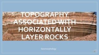
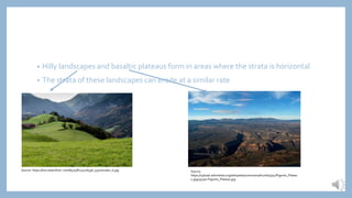
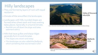
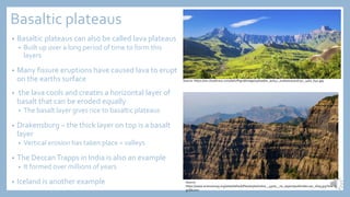
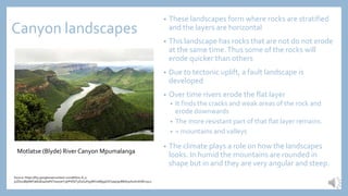
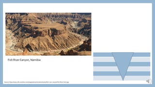
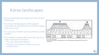
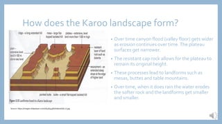
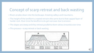
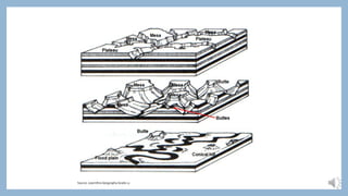
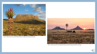
TOPOGRAPHY
ASSOCIATED WITH
HORIZONTALLY
LAYER ROCKS
Geomorphology
Characteristics and
processes associated with
development of hilly
landscapes and basaltic
plateaus
• Stratified rock – rock composed of layers or strata
• Bedding planes – planes separating layers of rock
• Lava flow- lava pours out onto earths surface where it cools and becomes solid
• Dolerite sill- a horizontal layer of igneous rock that has formed along a bedding plane
• Igneous rock – rock that forms when magma cools and condenses
• Landscapes- area with a number of landforms
• Plateau – large high lying area that is relatively flat
• Sedimentary rock- rock that is formed through deposition and compression of sediment
• Sheet wash- rainfall flowing over the land as a sheet
• Gullies- small narrow, long areas of erosion on a long slope
• Badlands- a landscape with narrow gullies and sharp ridges formed in arid climates
• Mass waiting- movement of eroded material down a slope.
• Hilly landscapes and basaltic plateaus form in areas where the strata is horizontal
• The strata of these landscapes can erode at a similar rate
Source: https://live.staticflickr.com/8475/8125216936_537ce01a61_b.jpg Source:
https://upload.wikimedia.org/wikipedia/commons/thumb/5/5c/Pajarito_Platea
u.jpg/350px-Pajarito_Plateau.jpg
Hilly landscapes
• They are formed by layers of rock with equal
resistance
• Climate of the area effect the landscapes
• Landscapes with hilly rounded slopes are
formed when sheet wash and mass waiting
takes places. Generally in a humid climate.
• Rainfall runs off down the slope and takes
sediment with it.
• Hills that have gullies and sharp ridges
generally form in arid climates
• The slopes are uneven and steep
• This landscape can also called the Badlands,
which something that was termed in USA
Source: https://www.thesouthafricaguide.com/wp-content/uploads/2010/01/Valley_of_A_thousan_hills.jpg
Valley of thousand
Hills KZN
Source: https://www.doi.gov/sites/doi.gov/files/uploads/badlands-np-andreas-eckert-ste-
small_1.jpg
Badlands
USA
Basaltic plateaus
• Basaltic plateaus can also be called lava plateaus
• Built up over a long period of time to form this
layers
• Many fissure eruptions have caused lava to erupt
on the earths surface
• the lava cools and creates a horizontal layer of
basalt that can be eroded equally
• The basalt layer gives rice to basaltic plateaus
• Drakensburg – the thick layer on top is a basalt
layer
• Vertical erosion has taken place = valleys
• The DeccanTrapps in India is also an example
• It formed over millions of years
• Iceland is another example
Source: https://res.cloudinary.com/dah7fhgud/image/upload/w_auto,c_scale/0050016752_1460_640.jpg
Source:
https://www.sciencemag.org/sites/default/files/styles/inline__450w__no_aspect/public/deccan_16x9.jpg?itok=U
gUSk2mx
Characteristics and
processes associated with
the development of
canyon landscapes,
Karoo and scarp retreat
• Tectonic uplift – rising of a land mass due to tectonic uplift
• Cap rock- horizontal layer of hard and resistant rock found at the top of a
mountain
• Mesas – flat topped table mountain with great width and height
• Buttes- flat topped hills with greater height than width
• Point buttes- narrows hills with sharp peaks at the top
• Conical hills- small pointed hills
• Scarp retreat – erosion of scarp slope causes loss of ground over the whole slope,
but no loss of height
• Pediplain- large, low angled plain
Canyon landscapes
• These landscapes form where rocks are stratified
and the layers are horizontal
• This landscape has rocks that are not do not erode
at the same time.Thus some of the rocks will
erode quicker than others
• Due to tectonic uplift, a fault landscape is
developed
• Over time rivers erode the flat layer
• It finds the cracks and weak areas of the rock and
erode downwards
• The more resistant part of that flat layer remains.
• = mountains and valleys
• The climate plays a role on how the landscapes
looks. In humid the mountains are rounded in
shape but in arid they are very angular and steep.
Motlatse (Blyde) River Canyon Mpumalanga
Source: https://lh3.googleusercontent.com/bN7iu-8_u-
jvZDoUBjk88Ya6bsEa4HaF6Tswa7eYzjlrPiifQT3OUxyFq3WKtaWjq9VxFyaq09oMbA3ohuAmf1M=s512
Fish River Canyon, Namibia
Source: https://www.info-namibia.com/images/attractions/landmarks/fish-river-canyon/Fish-River-Intro.jpg
Karoo landscapes
• Karoo landscapes develop from the canyon
landscape
• The Karoo landscape has flat topped
mountains or hills that have concave slopes
and vary in size
• It is very dry in these areas and there is little
rainfall
• The landforms generally have the cap rock
that is resistant to erosion
• The cap is generally dolerite
• Sandston and shale are below (they get
eroded away)
Source: https://encrypted-
tbn0.gstatic.com/images?q=tbn%3AANd9GcTU1Lrntp0_PDKMjJtB69GTb16UqGspQFV9YPbYF1shjKv_Mt
c3&usqp=CAU
How does the Karoo landscape form?
• Over time canyon flood (valley floor) gets wider
as erosion continues over time.The plateau
surfaces get narrower.
• The resistant cap rock allows for the plateau to
remain its original height.
• These processes lead to landforms such as
mesas, buttes and table mountains.
• Over time, when it does rain the water erodes
the softer rock and the landforms get smaller
and smaller.
Source: https://images.slideplayer.com/16/4894987/slides/slide_6.jpg
Concept of scarp retreat and back wasting
• Rivers erodes down into the landscape. Creating valleys and mountains.
• The height of the landforms created remains the same due to that capped layer of
harder rock. Over time the landforms do get narrower due to erosion.
• The slopes are steep and they retreat parallel to them selves (inwards) over time
• This process = scarp retreat or back wasting
Source: LearnXtra Geography Grade 12
Source: https://i.pinimg.com/736x/6f/4f/43/6f4f431c126899c1ab133a8529ad49e6.jpg
Source: https://i.pinimg.com/originals/57/0e/45/570e4528a7c6aa9357c5fbe30e27c5bb.jpg

1. Topography associated with horizontally layer rocks.pdf

  • 1.
  • 2.
    Characteristics and processes associatedwith development of hilly landscapes and basaltic plateaus
  • 3.
    • Stratified rock– rock composed of layers or strata • Bedding planes – planes separating layers of rock • Lava flow- lava pours out onto earths surface where it cools and becomes solid • Dolerite sill- a horizontal layer of igneous rock that has formed along a bedding plane • Igneous rock – rock that forms when magma cools and condenses • Landscapes- area with a number of landforms • Plateau – large high lying area that is relatively flat • Sedimentary rock- rock that is formed through deposition and compression of sediment • Sheet wash- rainfall flowing over the land as a sheet • Gullies- small narrow, long areas of erosion on a long slope • Badlands- a landscape with narrow gullies and sharp ridges formed in arid climates • Mass waiting- movement of eroded material down a slope.
  • 4.
    • Hilly landscapesand basaltic plateaus form in areas where the strata is horizontal • The strata of these landscapes can erode at a similar rate Source: https://live.staticflickr.com/8475/8125216936_537ce01a61_b.jpg Source: https://upload.wikimedia.org/wikipedia/commons/thumb/5/5c/Pajarito_Platea u.jpg/350px-Pajarito_Plateau.jpg
  • 5.
    Hilly landscapes • Theyare formed by layers of rock with equal resistance • Climate of the area effect the landscapes • Landscapes with hilly rounded slopes are formed when sheet wash and mass waiting takes places. Generally in a humid climate. • Rainfall runs off down the slope and takes sediment with it. • Hills that have gullies and sharp ridges generally form in arid climates • The slopes are uneven and steep • This landscape can also called the Badlands, which something that was termed in USA Source: https://www.thesouthafricaguide.com/wp-content/uploads/2010/01/Valley_of_A_thousan_hills.jpg Valley of thousand Hills KZN Source: https://www.doi.gov/sites/doi.gov/files/uploads/badlands-np-andreas-eckert-ste- small_1.jpg Badlands USA
  • 6.
    Basaltic plateaus • Basalticplateaus can also be called lava plateaus • Built up over a long period of time to form this layers • Many fissure eruptions have caused lava to erupt on the earths surface • the lava cools and creates a horizontal layer of basalt that can be eroded equally • The basalt layer gives rice to basaltic plateaus • Drakensburg – the thick layer on top is a basalt layer • Vertical erosion has taken place = valleys • The DeccanTrapps in India is also an example • It formed over millions of years • Iceland is another example Source: https://res.cloudinary.com/dah7fhgud/image/upload/w_auto,c_scale/0050016752_1460_640.jpg Source: https://www.sciencemag.org/sites/default/files/styles/inline__450w__no_aspect/public/deccan_16x9.jpg?itok=U gUSk2mx
  • 7.
    Characteristics and processes associatedwith the development of canyon landscapes, Karoo and scarp retreat
  • 8.
    • Tectonic uplift– rising of a land mass due to tectonic uplift • Cap rock- horizontal layer of hard and resistant rock found at the top of a mountain • Mesas – flat topped table mountain with great width and height • Buttes- flat topped hills with greater height than width • Point buttes- narrows hills with sharp peaks at the top • Conical hills- small pointed hills • Scarp retreat – erosion of scarp slope causes loss of ground over the whole slope, but no loss of height • Pediplain- large, low angled plain
  • 9.
    Canyon landscapes • Theselandscapes form where rocks are stratified and the layers are horizontal • This landscape has rocks that are not do not erode at the same time.Thus some of the rocks will erode quicker than others • Due to tectonic uplift, a fault landscape is developed • Over time rivers erode the flat layer • It finds the cracks and weak areas of the rock and erode downwards • The more resistant part of that flat layer remains. • = mountains and valleys • The climate plays a role on how the landscapes looks. In humid the mountains are rounded in shape but in arid they are very angular and steep. Motlatse (Blyde) River Canyon Mpumalanga Source: https://lh3.googleusercontent.com/bN7iu-8_u- jvZDoUBjk88Ya6bsEa4HaF6Tswa7eYzjlrPiifQT3OUxyFq3WKtaWjq9VxFyaq09oMbA3ohuAmf1M=s512
  • 10.
    Fish River Canyon,Namibia Source: https://www.info-namibia.com/images/attractions/landmarks/fish-river-canyon/Fish-River-Intro.jpg
  • 11.
    Karoo landscapes • Karoolandscapes develop from the canyon landscape • The Karoo landscape has flat topped mountains or hills that have concave slopes and vary in size • It is very dry in these areas and there is little rainfall • The landforms generally have the cap rock that is resistant to erosion • The cap is generally dolerite • Sandston and shale are below (they get eroded away) Source: https://encrypted- tbn0.gstatic.com/images?q=tbn%3AANd9GcTU1Lrntp0_PDKMjJtB69GTb16UqGspQFV9YPbYF1shjKv_Mt c3&usqp=CAU
  • 12.
    How does theKaroo landscape form? • Over time canyon flood (valley floor) gets wider as erosion continues over time.The plateau surfaces get narrower. • The resistant cap rock allows for the plateau to remain its original height. • These processes lead to landforms such as mesas, buttes and table mountains. • Over time, when it does rain the water erodes the softer rock and the landforms get smaller and smaller. Source: https://images.slideplayer.com/16/4894987/slides/slide_6.jpg
  • 13.
    Concept of scarpretreat and back wasting • Rivers erodes down into the landscape. Creating valleys and mountains. • The height of the landforms created remains the same due to that capped layer of harder rock. Over time the landforms do get narrower due to erosion. • The slopes are steep and they retreat parallel to them selves (inwards) over time • This process = scarp retreat or back wasting
  • 14.
  • 15.