
Recommended
More Related Content
What's hot
What's hot (20)
Similar to Document sp
Similar to Document sp (20)
Recently uploaded
Recently uploaded (20)
Document sp
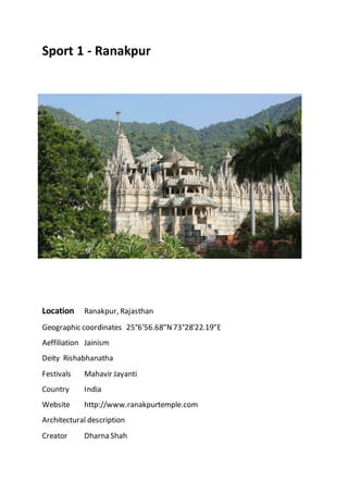
- 1. Sport 1 - Ranakpur Location Ranakpur, Rajasthan Geographic coordinates 25°6′56.68″N73°28′22.19″E Aeffiliation Jainism Deity Rishabhanatha Festivals Mahavir Jayanti Country India Website http://www.ranakpurtemple.com Architectural description Creator Dharna Shah
- 2. Date established 1437 CE Temple The renowned Jain temple at Ranakpur is dedicated to Tirthankara Rishabhanatha. Dharna Shah, a local Jain businessperson, started construction of the temple in the 15th century following a divine vision. The temple honors Adinath, the first Tirthankar of the present half-cycle(avasarpiṇī) according to Jain cosmology. The town of Ranakpur and the temple are named after the provincial ruler monarch, Rana Kumbha who supported the construction of the temple. Architecture Light colored marble has been used for the construction of this grand temple which occupies an area of approximately 60 x 62 meters. The temple, with its distinctive domes, shikhara, turrets and cupolas rises majestically from the slope of a hill. Over 1444 marblepillars, carved in exquisite detail, supportthe temple. The pillars are all differently carved and no two pillars are the same. It is also said that it is impossibleto count the pillars. Also all the statues face one or the other statue. There is one beautiful carving made out of a single marble rock wherethere 108 heads of snakes and numerous tails. One cannot find the end of the tails. The image faces all four cardinaldirections. In the axis of the main entrance, on the western side, is the largest image. The moolnayak of this temple is a 6 feet tall white colored idol of Adinatha. The temple is designed as chaumukha—with four faces. The construction of the temple and quadrupled image symbolizethe Tirthankara's conquestof the four cardinal directions and hence the cosmos. The architecture and stone carvings of the temple is based on the Ancient Mirpur Jain Temple at Mirpur in Rajasthan. The sun temple at Ranakpur dates back to the 13th century CE. After its destruction, it was rebuilt in the 15th century.
- 3. A temple dedicated to Suparshvanatha is also presenthere. The temple has an intrinsic architecture & this temple is also famous for erotic arts on the wall. Māru-Gurjara Architectureshow thedeep understanding of structures and refined skills of Rajasthanicraftmen of bygone era. Māru-Gurjara Architecture has two prominent styles Maha-Maru and Maru-Gurjara. According to M. A. Dhaky, Maha-Maru styledeveloped primarily in Marudesa, Sapadalaksha, Surasena and parts of Uparamala whereas Maru-Gurjara originated in Medapata, Gurjaradesa-Arbuda,Gurjaradesa-Anarta and someareas of Gujarat. Scholars such as GeorgeMichell, M.A. Dhaky, Michael W. Meister and U.S. Moorti believe that Māru-Gurjara TempleArchitectureis entirely Western Indian architecture and is quite different from the North Indian Temple architecture. There is a connecting link between Māru-Gurjara Architecture and Hoysala Temple Architecture. In both of these styles architecture is treated sculpturally. History Ranakpur Jain temple The construction is well documented in a 1437 CEcopper-plate record, inscriptions in the temple and a Sanskrittext Soma-Saubhagya Kavya.Inspired by a dreamof a celestial vehicle, Dhanna Shah, a Porwalfrom Ghanerao, commenced its construction, under the patronage of Rana Kumbha, then ruler of Mewar. The architect who oversaw theproject was named Deepaka. There is an inscription on a pillar near the main shrinestating that in 1439 Deepaka, an architect, constructed the temple at the direction of Dharanka, a devoted Jain.[1] When the ground floor was completed, Acharya Soma Sundar Suriof Tapa Gachha supervised the ceremonies, which are described in Soma- Saubhagya Kavya. Theconstruction continued until 1458 CE. The temple was renovated time to time. Some famililies supported the construction of devakulikas and mandaps. The descendants of Dharna Shah now mainly live in Ghanerao. The
- 4. Sport 2 Aravalli Supergroup On top of the Archean basement, the Aravallbi Supergroup overlies with clear unconformities separating the two strata. The Aravalli Supergroup is divided into three groups: lower Delwara Group, middle DebariGroup, and Upper Jharol Group.Thelower and middle groups shared similar lithology, where both groups aredominated by carbonates, quartzite, and pelitic rocks, thus suggesting a shelf depositional environment. Turbidite facies and argillaceous rocks areprominent in the upper Jharol group, thus suggesting a deep marine depositional environment.[8] The depositional age of these sequences ranges approximately from2.1 to 1.9 Ga. Three major episodes of deformation and metamorphism were involved in the Aravalli Supergroup, including foldings, shearing, kink bands and crenulations etc. Metamorphic grades of the rocks generally rangefrom greenschistfacies to amphibolite facies. Delhi Supergroup The upper Delhi Supergroup overlies on the Aravalli Supergroup with a clear unconformity. This supergroup hosts two main types of rocks: a thick sequence of volcanic rocks that is of continental affinity; and sedimentary rocks that representfluvial and shallow marine environments and deep marine depositional environment. The depositional age of these sequences is approximately from1.7 to 1.5 Ga. In the ‘North Delhi belt’, the Delhi Supergroup is classified into three groups: lower Raialo Group, middle Alwar Group, and upper Ajabgarh Group. The Raialo Group consists predominantly of mafic volcanic and calcareous rocks. The Alwar Group mainly consists of arenaceous and mafic volcanic rocks. The Ajabgarh Group is dominated by carbonate, mafic volcanic and argillaceous rocks. In thesouthern part, similar rock types, despite differentnames, are identified, wherethey are Gogunda Group (equivalent to Alwar group) and the
- 5. Kumbhalgarh Group (equivalent to Ajabgarh Group). Sport 3 – kelwa marbel mines
- 7. Sport 4- Zawar mine Location & accessibility: The Zawar Centre is located at about 45 Km south of Udaipur and 5 Kmfrom Tiri which is on the National Highway (NH) no. 8 that connects Udaipur to Ahmedabad. Zawar Mines is the nearest Railway Station which is about 7Kmfrom camp. Udaipur, the district headquarters is connected by train and air. The Dabok (Udaipur) Airportis 50 Km from the Zawar Centre and is approachablewith the NH-8 that bypasses Udaipur city. Air flights for Delhi, Mumbai and Jaipur operate from this airport. Weather: The climate is dry and pleasantbetween November and March. For remaining part of the year, climate remains dry and warm. The months from April to June are fairly hot. Winter season prevails between middle of November to February. Themonsoon season is active between July to middle of September. The temperature variation is between 40°- 45°C in summer and 5°- 10°C in winter. Woollen clothing’s are required during winter months. Facilities: The Center is nestled amidst the well known Zn-Pb deposits of Balaria, Mochia, Zawar Mala and Baroi around Zawar. The Centre is equipped with semi-permanentfacilities like accommodation, mess, dining space, library, recreational facilities etc for 30 participants at a time. Brief Geology: Palaeoproterozoic Aravalli metasediments that form southern continuity of the type Aravalli sequence in Girwa (Udaipur) valley are exposed in Zawar area. Importantrock types exposed around Zawar include dolomite and its facies variants like siliceous dolomite and gritty and feldspathic dolomite, greywacke, phyllite, quartziteand conglomerate. These rocks were
- 8. grouped together as Tiri Series, Zawar or Mochia Formation that forms middle part of the Aravalli supergroup. Geologically interesting sites: High percentage of exposures, profusesurface indications of mineralisation and a group of old workings and underground mines provides perfectgeological tour- Stromatolitic rock phosphatedeposit in Jhamarkotra (40km) Pb-Zn deposit, Rajpura-Dariba and Sindesar (135Km) Volcanic-hosted massivesulphidedeposit at Deri-Ambaji(200 Km) Gold deposit at Bhukia (150Km) Pb-Zn deposit at Agucha (250 km) Several serpentineslab making industrial units Tourist Attractions: HistoricalPalaces,fortand museum int Jaipur Lake-view Palace Udaipur Mt. Abu Haldi Ghati & Rakt Talai Specialisation: Zawar is studded with severalimpressiveold working that were important sourceof zinc-lead-silver ores in ancient India. Ithas a glorious history in mining and metallurgy of base metal ores and silver. Taking advantageof studies conducted by the Deptt. and rocks exposed, the FTC specializes in- Geological Mapping Mineral Exploration Geophysicaland Geochemical field studies Drilling Technology
- 9. Oredeposits modeling Orepetrology Geostatistics Activities: To enhance the necessary poolof expertise in different discipline of earth sciences within and outside the Department. The Centre will be engaged, in imparting induction level field training coursefor different batches of newly joined geologists of the department and from other organisations. The salient topics covered in Zawar Module includes training in- Geochemical mapping Techniques Mineral Exploration Surveying and detailed Geological Mapping Geophysical& Geochemical Prospecting Drilling Data integration Reserveestimation Besides, the FTC will be conducting the following capsule courses for the departmental and DGM participants- StructuralGeology Surveying using Total Station and GPS and data processing Geological mapping for officers of DGMs Systematic approach to mineral exploration for officers of DGM. Spot 5 - Fatehsagar lake Location: Udaipur, Rajasthan Coordinates 24.6°N 73.67°E Type reservoir, fresh water, polymictic Catchment area 54 km2 (21 sq mi) Basin countries India Max. length 2.4 km (1.5 mi) Max. width 1.6 km (0.99 mi) Surface area 4 km2 (1.5 sq mi)
- 10. Average depth5.4 m (18 ft) Max. depth 13.4 m (44 ft) Water volume 2.1×10⁶ m3 (74×106 cu ft) Shore length1 8.5 km (5.3 mi) Surface elevation 578 m (1,896 ft) Islands 3 (Nehru Park, Udaipur Observatory) Settlements Udaipur 1 Shore length is not a well-defined measure. Fateh Sagar Lake is situated in the city of Udaipur in the Indian state of Rajasthan. It is an artificial lake named after Maharana Fateh Singh of Udaipur and Mewar, constructed north- west of Udaipur, to the north of Lake Pichola in the 1680s. It is one of the four lakes of the Udaipur city; the other three being: the Lake Pichola (within the Udaipur town), Udai Sagar Lake, 13 kilometres (8.1 mi) to the east of Udaipur, and Dhebar Lake or Jaisamand Lake, 52 km (32 mi) south east of Udaipur. History Sunset over the lake In 1687, Maharana Jai Singh first constructed the lake but two hundred years later the earthen bund which formed the lake was washed away during floods, and thereafter Maharana Fatah Singh, in 1889, built the "Connaught Dam" on Lake Dewali to mark the visit of Duke of Connaught, son of Queen Victoria. The dam enlarged the lake, and it was later renamed, Fateh Sagar Lake. Hydrology and structure: The runoff emerging from surrounding hills drains into this lake. The lake is pear-shaped and is encircled by the Aravalli hills on three sides with a straight gravity stone masonry dam on the eastern side which has a spillway to discharge flood flows during the monsoon season.[5] Three causeways, one from Pichola Lake, the other from Madar Lake and the third one from Badi Lake lead to the Fateh Sagar Lake. There are three inlet channels, which feed the lake and an overflow section on the eastern side in the masonry dam of 800 metres (2,600 ft) length. Monsoon rains are the main source of all water to the lake. Initially constructed as an irrigation scheme, it is now the second major source of drinking water to the city of Udaipur and the irrigation supplies have been discontinued. A canal from the Rang Sagar Lake connects to the Fateh Sagar Lake. A gate controlled canal further connects Fateh Sagar Lake with Lake Pichhola.[6] The Northeastern embankment is known by three names viz., the Pal, the Drive, or Connaught Bund (bund means embankment). During drought conditions, when the rainfall is meager, water storage in the lake is insufficient to meet the needs. To prevent loss of water due to evaporation, cetyl alcohol (hexadecanol) is sprayed over the lake surface. connects to the Fateh Sagar Lake. A gate controlled canal further connects Fateh Sagar Lake with Lake Pichhola.[6] The Northeastern embankment is known by three names viz., the Pal, the Drive, or Connaught Bund (bund means embankment). During drought conditions, when the rainfall is meager, water storage in the lake is insufficient to meet the needs. Flora
- 11. Within the lake water, the flora recorded consists of the following. Macrophytes that have merged in the lake, floating macrophytes, the submerged macrophytes and the Phytoplankton. The Biomass production due to macrophytes is Id to be a maximum of 864.9 grams per square metre [g/m2] (0.1771 lb/sq ft) on the surface of the lake, with a minimum of 329 g/m² at the bottom. The biomass recorded due to plankton is reported to be at maximum during January, as 67 milligrams per litre [mg/L] (2.4×10⁻⁶ lb/cu in) at the surface and 23 g/L at the bottom of the lake. It is a low of 16 g/L at the surface and 1 at the bottom during July, during the rainy season. Fauna: The fauna recorded in the lake are the Zooplankton, Benthos and Fish. The economically important fishes reported are:[6] C. punctatus, C. reba, Catla catla, L. calbasu, Channa marulius, Cirrhina mrigala, L. gonius, Labeo rohita, Tor khudree, and Wallago attu.