Urban redevelopment
•Download as PPTX, PDF•
0 likes•61 views

Public infrastructure redevelopment proposal

Recommended
Recommended
More Related Content
What's hot
What's hot (20)
Similar to Urban redevelopment
Similar to Urban redevelopment (20)
Recently uploaded
Recently uploaded (20)
Urban redevelopment
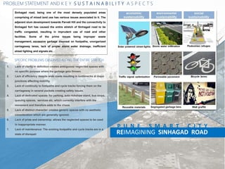
- 1. REIMAGINING SINHAGAD ROAD P U N E S M A R T C I T Y Sinhagad road, being one of the most densely populated areas comprising of mixed land use has various issues associated to it. The adjacent slum development towards Parvati Hill and the connectivity to Sinhagad fort has caused the entire stretch of Sinhagad road to be traffic congested, resulting in imprudent use of road and other facilities. Some of the prime issues being improper waste management, excessive garbage disposal on footpaths, unorganized carriageway lanes, lack of proper storm water drainage, inefficient street lighting and signals etc. 1. Lack of clarity in definition creates ambiguous/ neglected spaces with no specific purpose where the garbage gets thrown. 2. Lack of efficiency despite wide roads resulting in bottlenecks at major junctions affecting mobility. 3. Lack of continuity to footpaths and cycle tracks forcing them on the carriageway in several pockets creating safety issues. 4. Lack of dedicated spaces: for parking, auto rickshaw stand, bus stops, queuing spaces, services etc. which currently interfere with the movement and therefore adds to the chaos. 5. Lack of distinct character: creates generic spaces with no aesthetic consideration which are generally ignored. 6. Lack of pride and ownership: allows the neglected spaces to be used in inappropriate manner. 7. Lack of maintenance: The existing footpaths and cycle tracks are in a state of disrepair SPECIFIC PROBLEMS OBSERVED ALONG THE ENTIRE STRETCH PROBLEM STATEMENT AND K E Y S U S T A I N A B I L I T Y A S P E C T S
- 2. IMPROVING EFFICIENCY BY PROVIDING DEFINITION TO EDGES 1. Improving mobility by streamlining and optimizing the junctions. 2. Providing safety to pedestrians and cyclists by creating dedicated and clearly demarcated spaces. 3. To achieve continuity to footpaths and cycle tracks 4. To demarcate dedicated parking spaces which end up interfering with the pedestrian and cycle movement. INSTILLING A SENSE OF PRIDE AND OWNERSHIP BY CREATING CHARACTER SPACES AND PUBLIC PARTICIPATION SPACES 5. To identify and build a unique, distinctive character for the space. 6. Reinforcing the identity through use of specific elements 7. Carving out character spaces and public participation/ engagement spaces. ECONOMIC AND ENVIRONMENTALLY SUSTAINABLE SOLUTIONS 8. Environmentally sustainable solutions such as use of energy efficient materials and creating sponsorship spaces through design to ensure flow of revenue for development and future maintenance. Sinhagad road, being one of the most densely populated areas comprising of mixed land use has various issues associated to it. The adjacent slum development towards Parvati Hill and the connectivity to Sinhagad fort has caused the entire stretch of Sinhagad road to be traffic congested, resulting in imprudent use of road and other facilities. Some of the prime issues being improper waste management, excessive garbage disposal on footpaths, unorganized carriageway lanes, lack of proper storm water drainage, inefficient street lighting and signals etc. 1. Lack of clarity in definition creates ambiguous/ neglected spaces with no specific purpose where the garbage gets thrown. 2. Lack of efficiency despite wide roads resulting in bottlenecks at major junctions affecting mobility. 3. Lack of continuity to footpaths and cycle tracks forcing them on the carriageway in several pockets creating safety issues. 4. Lack of dedicated spaces: for parking, auto rickshaw stand, bus stops, queuing spaces, services etc. which currently interfere with the movement and therefore adds to the chaos. 5. Lack of distinct character: creates generic spaces with no aesthetic consideration which are generally ignored. 6. Lack of pride and ownership: allows the neglected spaces to be used in inappropriate manner. 7. Lack of maintenance: The existing footpaths and cycle tracks are in a state of disrepair REIMAGINING SINHAGAD ROAD P U N E S M A R T C I T Y SPECIFIC PROBLEMS OBSERVED ALONG THE ENTIRE STRETCH P R O B L E M S T A T E M E N T : A I M S A N D O B J E C T I V E S PROPOSAL ATTEMPTS TO ADDRESS THE FOLLOWING ISSUES
- 3. O B S E R V A T I O N S : N A V S H Y A M A R U T I C H O W K Zebra crossing at same level of the road reduces control of motor-vehicles and may cause accidents while pedestrians cross the street. Drainages and manholes hog the entire footpath and utility space at some extents of the street causing the surrounding area to remain in filth and inaccessible to pedestrian The pedestrian walkway directly in front of the garden is well shaded and can be used to develop a designed public space. Improper storm water drainage facilities at the edge of the carriageway cause water to accumulate during rainy season which makes the space to water- logged and unusable. The street on the opposite end of the garden has undeveloped plots which are currently being used as a bus parking that is causing road blockage when the buses turn to access it. CONTINUOUS, UNOBSTRUCTED, VEHICLE FREE EDGE WELL SHADED AREA WITH APPROX. 3M WIDE FOOTHPATH IDEAL FOR CREATING CHARACTER/ THEME SPACES/ PUBLIC PARTICIPATION SPACES PU LA DESHPANDE UDYAN PETROL PUMP REIMAGINING SINHAGAD ROAD P U N E S M A R T C I T Y
- 4. The junction at this point has two lanes joining the main road at an acute angle and needs to be resolved well. Lack of proper zebra crossing and defined carriageway cause haphazard movement of commuters. An existing toilet here hogs up the entire space for the pedestrian walkway and the cycle track. This needs to be relocated at a different location. The carriage way and the road divider throughout this stretch is in good condition but lacks proper crossing at regular interval. Road intersections require a raised edging to avoid motor vehicles crossing paths with pedestrians. The water treatment plant at this location is a major problem since the water tankers queue in the reverse direction on the encroached compound wall which is dangerous for pedestrians. WATER TREATMENT PLANT FOOTPATH BROKEN AT ENTRANCE AREA APPROX. 200 TANKERS ENTER THE GATE DURING THE MONTHS OF SUMMER I.E. 1 TANKER EVERY 2-3 MINS CREATING RAISED SHARED ZONE AT THE ENTRANCE WITH BOLLARDS DEFINING THE MOVEMENT CAN HELP SOLVE THE PROBLEM DESHPANDE CHOWK PUBLIC TOILET ENCROACHES FOOTPATH PUSHING THE PEDESTRIANS ON THE CARRIAGEWAY CREATING SAFETY ISSUES SMALLER SIZED MOBILE TOILETS NEED TO BE PROPOSED IN THE WIDER STRETCH OF THE FOOTPATH REIMAGINING SINHAGAD ROAD P U N E S M A R T C I T Y O B S E R V A T I O N S : D E S H P A N D E C H O W K
- 5. Slums have encroached the space dedicated for walkways and cycle tracks and are creating a chaos such as parking on the carriage way and carrying out their daily activities beyond this stretch of the street. Defining utility lanes and walkways can avoid haphazard parking at intersections and other parts of the road . More than two dozen water tankers queue in the reverse direction throughout this stretch and cause blocked flow of traffic movement on a regular basis. This space is an extension to the adjoining slums and have been left unutilized since the garbage is haphazardly deposited throughout the street. Encroachment of slums has resulted in a reduced carriageway for vehicles and a non existent walkway for pedestrians. TWO WHEELERS, HAWKERS, POROUS EDGE OF THE SLUMS ENCROACH THE FOOTPATH AND CYCLE TRACK FORCING THEM ON THE CARRIAGEWAY CREATING SAFETY ISSUES. CREATING DEDICATED 2 WHEELER PARKING SPACE WITHIN UTILITY LANE ALONG WITH VISUAL BARRIERS TO CONTAIN THE OUTDOOR ACTIVITIES OF THE SLUMS CAN HELP SOLVE THE PROBLEM. WATER TREATMENT PLANT THERE IS A SAFETY ISSUE FOR MOTORISTS AS A RESULT OF TANKERS COMING OUT IN PERPENDICULAR DIRECTION (APPROX. 1 TANKER EVERY 2-3 MINS) REVERSEING THE DIRECTION OF TANKER MOVEMENT WILL HELP SOLVE THE PROBLEM WALL BUILT TO COVER THE TOILETS THAT ENCROACHES THE FOOTPATH SPACE THERE IS NO FOOTPATH OR CYCLE TRACK IN THIS STRETCH CREATING A DEDICATED QUEING SPACE WITHIN UTILITY LANE WILL HELP SOLVE THIS PROBLEM REIMAGINING SINHAGAD ROAD P U N E S M A R T C I T Y O B S E R V A T I O N S : W A T E R T R E A T M E N T P L A N T
- 6. The street opposite to the temple consists of supermarkets and general stores but remains unhygienic due to the adjacent slum population. Parking dedicated for two wheelers could help organize the access to the shops. Lack of signals and crossings at intersections is a common problem throughout the road which needs to be addressed. The walkway in front of the Ramkrishna math temple has great potential to be designed well since it is major landmark and a well developed religious space. Lack of a multi-utility lane has caused the electrical boxes and other services to hog the already reduced space of the footpath. Parking at junctions creates chaos for pedestrians and motor vehicles which may cause road accidents. SLUM AREA SLUM AREA SLUM AREA NARROW ENCROACHED FOOTPATHS/ CURBS AT THE JUNCTION CREATE CREATING A BARRICADED SPILLOVER SPACE AT THE JUNCTIONS BY TIGHTENING THE TURNING RADII WILL ALLOW SMOOTH MOVEMENT OF THE VEHICLES WHICH IS CRITICAL FOR THE EFFICIENT MOBILITY OF THE ROADS. REIMAGINING SINHAGAD ROAD P U N E S M A R T C I T Y O B S E R V A T I O N S : D A N D E K A R B R I D G E J U N C T I O N SLUM AREA
- 7. PU LA DESHPANDE GARDEN PARVATI SP COLLEGE GROUND PESHWE PARK SARASBAUG NEHRU STADIUM SANAS GROUND RAMKRISHNA MATH GARDEN TEMPLE GROUND SLUM WATER TREATMENT PLANT RESIDENTIAL AREA COMMERCIAL AREA HOTEL POTENTIAL FOR CHARACTER SPACES PUBLIC UTILITY The design proposed in the 1.5 km stretch from Dandekar bridge to Navshya Maruti chowk can be applied as a broader context for the surrounding areas of the city since it acts as a gateway to Sinhagad fort on one direction and the historic parts of the core city on the other. The cyclists are the most prominent benefactors when the cycle track is continued further up to Sarasbaug, such that it connects with the Temple and other heritage city areas such as Sarasbaug, Nehru Stadium, Sanas sports Ground, S.P College and Parvati hill. Similar pilot startup projects can be indentified and integrated within the Pune cycle plan . CONTINUED STREAMLINE OF CYCLE TRACK & ROAD The space outside Okaya Friendship Garden has the potential to be developed into a character public space. The vast area of the garden has been overlooked by lack of lively spaces spilling out on the street. The compound wall of the garden can be developed such that it attracts more visitors by public participation and other landscaping elements, sit-outs, and space for artists to exhibit their artworks. C O N C E P T REIMAGINING SINHAGAD ROAD P U N E S M A R T C I T Y CHARACTER SPACE
- 8. S T R A T E G Y : T Y P I C A L R O A D S E C T I O N FOOTPATH Level +250mm CYCLE TRACK Level +100mm SHARED LANE Level +0.00mm ELEVATED PEDESTRIAN CROSSING Level +100mm MEDIAN Level +600mm CARRIAGEWAY Level +0.00mm MULTI-UTILITY AREA Level +100mm CAR PARKING Level +0.00mm BUS STOP Level +100mm GARBAGE BIN Level +100mm STREET LIGHT Level +100mm UTILITY BOX Level +100mm SITOUT Level +250mm FOOTPATH CYCLE TRACK MULTI UTILITY AREA CARRIAGEWAY 3 LANES CARRIAGEWAY 3 LANES MEDIAN MULTI UTILITY AREA CYCLE TRACK FOOTPATH S T A N D A R D R O A D S E C T I O N A D O P T E D F O R R E T R O- F I T T I N G REIMAGINING SINHAGAD ROAD P U N E S M A R T C I T Y
- 9. Parking space for 4 cars or 20 two wheelers at regular interval in front of shops. Additional space for footpath can be utilized to create character spaces and dedicated place for hawkers. Redefined T-junction with reduced turning radii and raised zebra crossing for pede- strian safety. Garbagebin provision and electrical boxes in multi-utility lane. Access to building entrance gate is a shared space for pedestrian & vehicle with bollards on both sides. P R O P O S A L : N A V S H Y A M A R U T I C H O W K Extended cycle track width at intersections for crossing The proposed T-Junction at Navshya Maruti chowk is re-imagined using standard three lane road sections to accommodate proper flow of vehicular and pedestrian traffic by providing raised zebra crossings that also serve as a speed breaker so that vehicles are enforced to stop at the signal. This junction is treated in a similar way and accommodates electrical boxes, garbage bins and street lamps in the multi utility lane. Vehicular parking is discouraged at intersections and pedestrian/bicycle crossing is provided at short intervals to discourage pedestrians crossing the road over the median. A standard three lane section is used throughout this stretch of the street which provides sufficient space for a streamlined flow of vehicular traffic as well as defined pedestrian walkways and bicycle track to efficiently segregate the different means of conveyance without any obstructions. Parking and provision of bus stop on the multi utility lane is indicated in the same. REIMAGINING SINHAGAD ROAD P U N E S M A R T C I T Y PU LA DESHPANDE UDYAN
- 10. Redefined road edges and larger space provided at junction to provide smooth traffic flow Parallel parking bays provided for 4 cars or 20 two wheelers The entrance for the water treatment plant has been made into a shared space for water tankers and pedestrians with provision for ramps and bollards. Provision for toilet facility relocated from the major intersection of this stretch to avoid blockage of walkway. This median at this intersection is opened from both sides to provide easy vehicular access. P R O P O S A L : D E S H P A N D E C H O W K The intersection at this section is a major cause for chaos in the flow of traffic since two lanes meet at an acute angle. The existing scenario is improved by providing a larger central junction space ad redefining the carriage way boundaries so that vehicles do not accommodate the dedicated space for walkway and cycle track. The multi utility lane is used as additional road space for queuing of motor vehicles to avoid bottlenecking of the traffic flow. The above standard road section shows a generic ramp that is provided at every short interval on the footpath for access to the carriage way at crossings. Provision of ramps help handicapped as well pedestrians to easily cross the street without having to take a step down. It also encourages crossing at the specific intervals. Bollards are used to obstruct any vehicle from using this space. PARVATI HILL WATER TREATMENT PLANT REIMAGINING SINHAGAD ROAD P U N E S M A R T C I T Y
- 11. The exit for the water treatment plant has been made into a shared space. The direction of the tankers queuing needs to be towards the flow of the traffic as opposed to the current scenario. The cycle track has been shifted to the multi utility lane at this stretch to provide ample space for the footpath without relocating the existing trees that are causing a blockage. Ample parking space is provided for the slum population. Shared space for pedestrians, bicyclist and vehicles at road intersections. Provision of bollards to enforce limited access for the slum populates. Boundary definition using bollards has to be provided to restrict the slum population. P R O P O S A L : W A T E R T R E A T M E N T P L A N T The road section at the second junction of this stretch has been reduced to a two lane carriage way due to lack of sufficient width available. The slum and compound wall encroachment is already causing the traffic to bottleneck here. Streamlining of the traffic here is essential if a definite rehabilitation of the existing slum population is not possible. The pedestrian walkway and bicycle track is defined and continued throughout which can be shared to provide wider space for the carriage way. PARVATI HILL WATER TREATMENT PLANT REIMAGINING SINHAGAD ROAD P U N E S M A R T C I T Y
- 12. Tightened turning radii at this junction streamlines the vehicular flow and provides safer crossing for pedestrians and bicyclists by introducing raised zebra crossings. The cycle track has been shifted to the multi utility lane at this stretch to provide ample space for the footpath without relocating the existing trees that are causing a blockage. Boundary definition using bollards has to be provided to restrict the slum population. Sufficient parking space and garbage bins are provided at short intervals to accommodate the necessary parking requirement. Defined edges of footpath with bollards at this junction help restrict the slum population to further encroach the carriage. Provision of bollards to enforce limited access for the slum populates. dandekar pool The Y - Intersection at the end of the road has been specifically designed to overcome the existing problems that are a major cause for road accidents. This stretch of the road mainly consists two lanes due to the substantial amount of encroachment done by the local slums existing here. Ideally, a three lane road section needs to be continued throughout a road but it is modified such that the multi utility lane can provide ample amount of organized parking for the locals living here. Since the width of the road at this point is significantly lesser than the average width throughout, the bicycle track can share the space with the pedestrian walkway by enforcing appropriate slowing mechanisms to solve the current scenario without having to rehabilitate the entire slum population. The turning radii at the junction is evidently reduced to streamline the traffic and discourage overtaking of motor vehicles. Similar strategy with raised zebra-crossings can help reduce road accidents and provide a safer crossing for pedestrians and bicyclists. Traffic signals are relocated directly opposite to the road to avoid ambiguity for vehicular traffic. RAMKRISHNA MATH P R O P O S A L : D A N D E K A R B R I D G E J U N C T I O N REIMAGINING SINHAGAD ROAD P U N E S M A R T C I T Y
- 13. The above image shows the existing bus stop in front of Okaya Friendship Garden. It is located halfway beyond the existing cycle track. The overlaid image to the right demonstrates the application of the chosen typical road section consisting of 2m wide multi utility lane, bicycle track and pedestrian walkway. The multi utility lane accommodates necessary facilities such as the bus stops, parking, light poles, garbage bins, and the proposed trees for shading. The walkway at this section has the potential to be developed as a character public space by constructing a featured wall which may depict historical heritage and other symbolic messages to encourage public interaction and overall define a character to one of the most important touristic destination of the city. Plan showing the generic location of the bus stop on the multi utility lane. M O N T A G E : S H O W I N G G E N E R A L S T R A T E G Y REIMAGINING SINHAGAD ROAD P U N E S M A R T C I T Y SPACE FOR BUS STOP ON UTILITY LANE CYCLE TRACK FOOTPATH
- 14. The road section beyond the slum area currently remains underutilized due to undefined boundaries of the road and garbage disposal surrounding the entire stretch. Since the available space for development at this point is significantly restricted due to the extensive encroachment of the slum populates, it is advisable that the available unused space be redefined to continue the pedestrian and cycle track throughout until a permanent solution can be attained when the slums are rehabilitated. The modified section beyond this point consists of two carriageway lanes, a cycle track and a pedestrian walkway. The multi utility lane is discontinued here. P L A N S H O W I N G Q U E U I N G O F W A T E R T A N K E R S M O N T A G E : N E A R S L U M A R E A REIMAGINING SINHAGAD ROAD P U N E S M A R T C I T Y FOOTPATH CYCLE TRACK ALONG UTILITY LANE
- 15. This specific location is a major issue since the government water treatment facility operates their activity here. The transiting water tankers cause a major obstruction to the flow of vehicular traffic since they exit reverse to the direction of traffic and obstruct the vehicles while turning. The third lane of the carriage way at this point is being used by the tankers. Ideally, it is advisable that the queuing be done in the property owned by the facility itself. The elevated and discontinue footpath here is obstructed by trees. This can be extended to provided sufficient space for pedestrians to walk and the cycle track can be continued adjacent to it. PLAN SHOWING THE ENTRANCE TO THE WATER TREATMENT FACILITY. REIMAGINING SINHAGAD ROAD P U N E S M A R T C I T Y M O N T A G E : W A T E R T R E A T M E N T A R E A RAISED SHARED SURFACE TO SLOW DOWN TANKERS CYCLE TRACK ALONG UTILITY LANE RAISED FOOTPATH TO BE WIDENED NO RAISED FOOTPATH OR CYCLE TRACK TREES OCCUPY THE EXISTING RAISED FOOTPATH
- 16. A Street with adequate space for walking and other activities is safer for pedestrians and allows for smoother motor vehicle movement. Since larger turning radii encourage faster vehicle speeds, tighter corners are preferred because they improve safety for pedestrians and cyclists. Existing trees introduced some constraints in the alignment of the footpath and cycle track. In the interest of increasing the amount of space available for pedestrians and to increase intersection capacity, the design intervenes much of the on-street parking that was present close to the junction. However, vehicle users may balk at the prospect of having to walk 100–200 m from parking spaces, given that they presently park immediately in front of their final destinations. Enforcement will be necessary to ensure that they do not encroach on the footpaths or cycle tracks. Despite these challenges, the design introduces ramps, reduced turning radii, and other self-enforcing elements in order to improve safety for all users. Social Sustainability Environmental Sustainability Economic Sustainability economic sustainability environmental sustainability social sustainability Solar powered street lights Storm water infiltration Pedestrian refuges Traffic signal optimization Permeable pavement Bicycle lanes Reusable materials Segregated garbage bins Wall graffiti conclusion K E Y S U S T A I N A B I L I T Y A S P E C T S