Balintawak Interchange in Metro Manila
•
1 like•1,400 views

Opened in 1968 as part of the initial 37-kilometer (23 mi) NLEX segment between Quezon City and Guiguinto, Bulacan, it was one of the first projects of the Construction and Development Corporation of the Philippines, now the Philippine National Construction Corporation (PNCC).

Recommended
More Related Content
What's hot
What's hot (20)
Similar to Balintawak Interchange in Metro Manila
Similar to Balintawak Interchange in Metro Manila (20)
More from haroldtaylor1113
More from haroldtaylor1113 (20)
Recently uploaded
Recently uploaded (20)
Balintawak Interchange in Metro Manila
- 1. Balintawak Interchange ADAMSON UNIVERSITY #900 Marcelino Street, Ermita Manila
- 2. PRESENTED BY: Anjali Krystal Nosa Elloso ,BSCE Joshua D. Nuñez, BSCE Joseph Samuel Rosario, BSCE Bernadeth Tumpang, BSCE PRESENTED TO: Dr. Tomas U. Ganiron Jr
- 3. What is an Interchange? Interchange is a road junction that uses grade separation, and typically one or more ramps, to permit traffic on at least one highway to pass through the junction without interruption from other crossing traffic streams. it differs from a standard intersection, where roads cross at grade. The slip roads to and from the motorway carriageways converge at a single roundabout, which is grade- separated from the motorway lanes with bridges.
- 4. What Are the Types of Interchange? Directional Interchange Cloverleaf Interchange Diamond Interchange Trumpet Interchange Single Point Urban Interchange (SPUI) Road Signs At Highway Interchanges Directional Interchange
- 5. Directional Interchange A directional interchange is placed at an intersection of two highways where a high volume of traffic desires to transfer between only two legs of the interchange. Directional interchanges have increased ramp speed and capacity and require less space, when compared to a conventional cloverleaf interchange, but they are more costly to construct due to an increased number of ramps.
- 6. Cloverleaf Interchange Probably the most common highway interchange out there. Cloverleaf interchange is designed to allow drivers to make turns off and onto the highway from four directions using loop ramps. Loop ramps safely accommodate left turns and eliminates all cross traffic conflicts.
- 7. Trumpet Interchange A trumpet interchange may be used instead of a T-intersection when one highway terminates into another highway. A trumpet interchange may be seen as a combination of a directional and a diamond-shaped interchange.
- 8. Single Point Urban Interchange (SPUI) A single point urban interchange is a traffic signal-controlled diamond-shaped interchange. Through traffic, traffic turning left or off the interchange is controlled by a single set of traffic signals that are located at the top of the interchange. The design is utilized at busy interchanges with limited space available, it's main advantage is that it allows opposing left turns to proceed simultaneously.
- 9. Diamond Interchange Diamond interchange design is utilized when a busy freeway intersects with a lesser road. Traffic leaves and enters the highway through four ramps. Left turns are made after leaving the highway. Due to the limitations in design, an increase in the volume of traffic on the crossroad leads to congestion and increased waiting time for traffic leaving the highway.
- 10. Road Signs At Highway Interchanges In order to assist drivers with navigating complex interchanges, green guide signs are installed on approaches and directly at the interchange. Individual guide signs may be installed above separate lanes to let drivers traveling in the lane know their options.
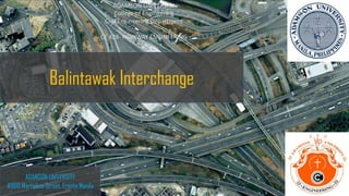
- 12. THE BALINTAWAK INTERCHANGE The balintawak interchange, also known as the balintawak cloverleaf ● Two-level cloverleaf interchange in Quezon City, Metro Manila, the Philippines which serves as the junction between Epifanio De Los Santos Avenue (EDSA) and the North Luzon Expressway (NLEX). ● Constructed in 1966 by the construction and Development Corporation of the Philippines.
- 13. History Balintawak Interchange ● Opened in 1968 as part of the initial 37-kilometer (23 mi) NLEX segment between Quezon City and Guiguinto, Bulacan, it was one of the first projects of the Construction and Development Corporation of the Philippines, now the Philippine National Construction Corporation (PNCC).
- 14. Construction of Balintawak Interchange • Was precipitated by the large number of motor vehicles in Manila and the surrounding suburbs in the 1960s, which contributed to significant traffic congestion. On june 25, 1966, President Ferdinand Marcos ordered the Department of Public Works to undertake the construction of a number of road projects to be financed through World War II reparations, including the construction of interchanges on vital intersections along EDSA ● This order would later lead to the construction of this interchange, replacing a previous roundabout between EDSA, Bonifacio Avenue and the Quirino Highway, and the Magallanes Interchange between EDSA and the South Luzon Expressway (SLEX), which opened in 1975. A shrine to Andres Bonifacio would later be constructed inside the interchange, which underwent a ₱13 million renovation in 2009.
- 15. Disadvantages of Balintawak Interchange ● Occupy too much land making them not ideal for cramped places, and this type of interchange is quite prone to weaving problems, where cars leaving and entering one road weave in each others paths, though the problem is not as problematic as in a rotunda interchange ● Flooding in the area around the balintawak interchange is a problem, with the interchange being named in 2014 as one of the twenty-two most flood- prone road ways in Metro Manila.
- 16. Flooding Area
- 17. BALINTAWAK INTERCHANGE: VOLUME: With some 30,000 vehicles estimated to use the new road daily during its first year of operation, since its opening it has helped to relieve traffic on the older Balintawak Interchange connecting Epifanio de los Santo Avenue (EDSA) to the NLEx, which is three times smaller. LENGTH: 37-kilometer (23 mi) NLEx segment between Quezon City and Guiguinto, Bulacan, it was one of the first projects of the Construction and Development Corporation of the Philippines, now the Philippine National Construction Corporation (PNCC). TYPE: Two-Level Interchange Roads At Junctions Epifanio de los Santos Avenue North Luzon Expressway N160 (Bonifacio Avenue)
- 18. END OF SLIDES