
Recommended
More Related Content
What's hot
What's hot (18)
Viewers also liked
Similar to Tlmače
Similar to Tlmače (20)
Recently uploaded
Recently uploaded (20)
Tlmače
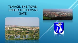
- 1. TLMAČE, THE TOWN UNDER THE SLOVAK GATE
- 2. SLOVAKIA
- 3. LEVICE
- 4. WHERE CAN YOU FIND US ? Tlmače is situated in the southwest of Slovakia It is in region Nitra, district Levice The town Tlmače lies at 48° 17´21“ N a 18° 31´ 55“ E Altitude in the centre of the town is 176 m Total area is 4,64 km2
- 5. SOME PHOTOS OF TLMAČE
- 6. TOWN VIEW TLMAČE The town Tlmače consists of the (old) village Tlmače on the left bank of the Hron river and the housing estate Lipník on its right bank. The lower, older part of Tlmače has 699 inhabitants and Lipník is home to 3181 inhabitants.
- 7. NATURAL CONDITIONS: The town lies close to the south-west foothills of the Štiavnicke vrchy mountains where the river Hron leaves the geomorphological narrowing called The Slovak Gate. Its climate is warm and dry with an average temperature of 9 °C and it has 600mm of rainfall per year on average.
- 8. THE HISTORY OF THE TOWN TLMAČE The first written notice of Tlmače comes from the year 1075. It mentions the fishing village Talmach, which belonged to the abbey of Svätý Beňadik. A part of the village later belonged under the power of the Tekov castle and a few yeomen families. In the year 1565 it belonged to the Ostrihom Chapter. In 1601 the ottomans set fire to Tlmace and in 1709 it witnessed a battle of the emperors army against the rebelling troops of nobleman Rakoci. Between 1938 and 1945 after the Vienna Arbitration Tlmače became a frontier village on the border with Hungary. The village saw significant development in 1949, with the construction of a plant for production of power boilers and the construction of the Lipník housing estate on the opposite site of the river. On 1st January Tlmace became a town.
- 9. IMPORTANT SIGHTS: The monument to the victims of the Slovak National Uprising on the Slovak National Uprising Square (renovated in 2011) The Milan Rastislav Štefánik monument
- 10. IMPORTANT SIGHTS: The roman-catholic church of Our Lady of Sorrows from the year 1926 The roman-catholic church of the Sacred Heart of Jesus from 2012
- 11. The Slovak double cross and the memorial plaque in the place of the old slavic hill fort Hrádze (also known as Festung), which stand at the southern edge of the Slovak Gate. A large archaeological research has been made at this place. The hill fort had the shape of an uneven quadrangle with an area of 2.4 hectare and was fortified with a bulwark which is visible even today.
- 12. SPORT AND RECREATION: Wellness centre Beach lake Tennis court Football stadium
- 14. DAM ON THE RIVER HRON
- 15. NEXT TIME WE WILL SHOW YOU OUR SCHOOL VII.A TEAM