
Recommended
Recommended
More Related Content
Similar to The Northern Lakes and Surrounding Plains in the Nile Delta, Egypt How Are They Now and How Will They Are in Light of Climate Changes
Similar to The Northern Lakes and Surrounding Plains in the Nile Delta, Egypt How Are They Now and How Will They Are in Light of Climate Changes (20)
More from ijtsrd
More from ijtsrd (20)
Recently uploaded
Recently uploaded (20)
The Northern Lakes and Surrounding Plains in the Nile Delta, Egypt How Are They Now and How Will They Are in Light of Climate Changes
- 1. International Journal of Trend in Scientific Research and Development (IJTSRD) Volume 6 Issue 6, September-October 2022 Available Online: www.ijtsrd.com e-ISSN: 2456 – 6470 @ IJTSRD | Unique Paper ID – IJTSRD52183 | Volume – 6 | Issue – 6 | September-October 2022 Page 1876 The Northern Lakes and Surrounding Plains in the Nile Delta, Egypt: How Are They Now and How Will They Are in Light of Climate Changes Khaled Abdel-Kader Ouda Geology Department, Faculty of Science, Assiut University, Assiut, Egypt ABSTRACT In addition to the consensus of scientists, environmental experts, fisheries and beach research in Egypt about the pollution of the northern lakes in the Egyptian delta and the collapse of its ecosystem as a result of using these lakes as a permanent drain for agricultural, health and industrial wastewater - untreated - for the delta governorates surrounding the lakes - the continuous drying processes in the Manzala lakes Burullus, Mariout and Idku, which the government undertakes on the one hand, and individuals on the other hand, have caused a change in the morphology of the lakes and a reduction in their areas, ranging between 46% and 83% of their original areas. Drying and filling works are still going on for these lakes, without taking into account the new climatic conditions that have hit the world, which in turn will lead to a rise in the global sea level (MGSL) during this century by an amount that may reach a maximum of one meter. This will result in the invasion of all the northern lakes of the Nile Delta, in addition to the surrounding dry low plains along the northern coast of the delta, and then the invasion of all the areas that were previously deducted and drained from the lakes with their urban, agricultural and industrial projects, as well as the remaining submerged areas of these lakes, which in turn will lose their characteristics to become part of the Mediterranean. This study aims to determine the quantitative and qualitative size of the certain risks that will face the northern lakes and the plains surrounding them in the Nile delta as a result of the global rise in sea level during this century, the coastal threat sources and the traditional defensive policies that must be followed to avoid all these risks. How to cite this paper: Khaled Abdel- Kader Ouda "The Northern Lakes and Surrounding Plains in the Nile Delta, Egypt: How Are They Now and How Will They Are in Light of Climate Changes" Published in International Journal of Trend in Scientific Research and Development (ijtsrd), ISSN: 2456- 6470, Volume-6 | Issue-6, October 2022, pp.1876-1936, URL: www.ijtsrd.com/papers/ijtsrd52183.pdf Copyright © 2022 by author(s) and International Journal of Trend in Scientific Research and Development Journal. This is an Open Access article distributed under the terms of the Creative Commons Attribution License (CC BY 4.0) (http://creativecommons.org/licenses/by/4.0) KEYWORDS: Climate Change, Nile Delta, Lake Manzala, Lake Burullus, Lake Mariout, Lake Idku 1. INTRODUCTION Scientists, environmental experts, fisheries and beach researchers in Egypt have unanimously agreed on the fact of environmental pollution of all the northern lakes in the Egyptian delta, which represents the humid neutral zone that separates the sea from the dry agricultural plains, as a result of using these lakes as a permanent drain for agricultural, health and industrial wastewater - untreated - for the delta governorates surrounding the lakes on the one hand, and increasing the mixing of sea water with lakes on the other hand. This led to the concentration of cadmium, mercury, zinc, lead and copper salts not only in the lake water - but also in the plants that grow in the lakes and the fish that feed on these plants, causing the death of many fish and making the rest of them unfit for human consumption. The mixing with sea water also led to an increase in the proportion of fresh water in the lakes, which in turn led to the spread of bushes and reeds. Also, dumping industrial and health wastes in lakes caused a lack of oxygen and a concentration of hydrogen sulfide in some of these lakes, which prompted the Ministry of Health and Population to warn against eating or trading Lake Mariout fish due to the high toxicity of fish extracted from the waters of this lake. The encroachments and pollution led to a change in the chemical composition and the collapse of the ecosystem of all the northern lakes in the Egyptian delta, which severely affected the fish wealth in these IJTSRD52183
- 2. International Journal of Trend in Scientific Research and Development @ www.ijtsrd.com eISSN: 2456-6470 @ IJTSRD | Unique Paper ID – IJTSRD52183 | Volume – 6 | Issue – 6 | September-October 2022 Page 1877 lakes, which represent about 60% of the total fish wealth in Egypt. In addition to this, the drying operations of the northern lakes in the delta continue, which the government is carrying out on the one hand for the purpose of urban development and the extension of roads, power lines, oil and natural gas projects, and individuals for the purpose of constructing random salinas and fish farms on the other hand. This caused the total areas of the northern lakes to be reduced and their areas to shrink between 50% and 83% of their original areas - which resulted in changing the topography of the northern coast of the Egyptian Delta - in terms of the borders of the beaches and the areas of wetlands that separate the delta from the sea (Ouda, 2010). In a study by Mohamad (2011) on Lake Mariout, it was found that it receives 7.5 million cubic meters / day of wastewater resulting from agricultural drainage and untreated industrial and municipal wastewater, which increased the concentration of heavy metals (cadmium, lead, chromium and nickel dissolved in the lake water). According to El-Naggar and Rifaat (2017) Lake Mariout was one of the most important shallow coastal lakes north of the Nile Delta in Egypt, which produces between 50 and 70% of the total fish production of the coastal lakes, but it was widely used for the discharge of industrial waste and sewage and agricultural drainage. As a result of environmental degradation, it has changed from being the most productive fish resource of the four great brackish water lakes in Egypt to the least productive in two decades. In 2014, Hereher explained that Lake Manzala, once the largest coastal wetland along the Mediterranean coast, is heading for its disappearance by two opposing forces, one of which is the shrinking of the water body by deposition of sediment from agricultural land and an abundance of grasses and marsh plants as well. as drying practices for agriculture, while another force includes removing the coastal sand strip separating the lake from the Mediterranean by erosion, which should eventually turn the lake into a coastal dam rather than a closed coastal lake. In a geochemical study of the waters of Lake Manzala for both El-Badry and. Khalifa (2017), the results showed that the arsenic content in the lake ranges from 4.6 to 22 ppm (parts per million), with an average of 12 ppm, which is about 8 times the average of the Earth's crust. Selenium concentrations range from 3-5 ppm with an average of 4 ppm, which is about 80 times the average crust of the Earth. The tin in the studied lake also ranged between 25-90 ppm with an average of 46 ppm, which is about 9 times the average of the earth's crust. The highest values of arsenic, selenium and tin extended towards the industrial zone in Port Said Governorate. To sum up what the researchers said statistically, pollution indicators reflect a high level of pollutants in the vicinity of industrial activity around Port Said and Damietta governorates, while agricultural pollution is concentrated in the banks of Al-Serw and Bahr Al- Baqar. This was followed by Ismail and Hettiarachchi (2017), Bek et al. (2019) and Elmorsi et al. (2019) who confirmed that Lake Manzala is exposed to high inputs of pollutants from industrial, domestic and agricultural sources. According to these authors heavy metal pollution is the most important type of pollution in the lake, which receives mixed discharges from densely populated areas, and that climatic gases and large quantities of particles, nutrients, bacteria and toxic organic materials are transferred to the lake through the discharge of sewage, especially the Bahr al-Baqar drain. In an analysis of samples of fish extracted from Lake Manzala by Sallam et al. (2019) high concentrations of the elements mercury, lead and cadmium were detected in Nile tilapia, gray mullet, and African catfish, respectively. The levels of mercury and cadmium contamination showed significant differences between summer and winter in three different types of fish that were examined. In a study by Shoman (2018) about volume changes in Lake Manzala using remote sensing and GIS, the results showed that the Manzala Lake area decreased by more than 60% during the study period from 1972 to 2017. Also, Al-Muzayen (2019), Director General of Production at the Public Authority for Fisheries Development, found that the policy of drying of Lake Manzala led to a decrease in the area of the lake to less than 25% of its original area. The draining, which is considered one of the most effective and destructive policies for fisheries, has led to a change in the topography of the lake and its collapse. According to him, the most important problems of the lake are: A- Pollution resulting from untreated sewage from the Bahr al-Baqar drain, where it pours into Lake Manzala. The quantities of untreated sewage discharged by this drain are estimated at 1.5 million cubic meters per day (of which about 1.25 million cubic meters are from Greater Cairo alone). B- Pollution as a result of sewage resulting from the remnants of housing communities whose waste is dumped on both sides of the Bahr al-Baqar drain and the shores of the lake, or directly received by sewage networks from cities and villages overlooking Lake Manzala directly, the nearest of which is Moheb and Sayala drain in Damietta, as well as the sewage
- 3. International Journal of Trend in Scientific Research and Development @ www.ijtsrd.com eISSN: 2456-6470 @ IJTSRD | Unique Paper ID – IJTSRD52183 | Volume – 6 | Issue – 6 | September-October 2022 Page 1878 system in the Al-Heishah Al-Khayyat area in Damietta. Although there is a purification plant, it has been inoperative for two years and receives sewage waste directly without any treatment. C- Pollution resulting from untreated industrial wastewater. D- Pollution resulting from agricultural drainage laden with pesticides. The quantities of water discharged by these drains into the lake are estimated at about 6 million cubic meters / day. As for Lake Burullus, Dumont and. El-Shabrawy (2007) explained that since the construction of the High Dam, the Nile River has stopped the flow of the annual sediment layer into the river delta, which made the decline and coastal erosion continue and now consume the sandy strip which separates the Lake from the sea. In the Annual Report on Lake Burullus (2018-2019) for the Environmental Affairs Agency, the Egyptian Lakes Environmental Monitoring Program, it was stated that the area of the lake had shrunk from 165,000 feddans to less than 70,000 feddans after nearly 60,000 feddans were deducted, and that weeds and linen cover about 25,000 thousand feddans, and that the silt rate is high due to the formation of many islands, and the pollution rate is high at rates exceeding the permissible limits in stages, as a result of dumping more than 57 billion cubic meters annually into the lake of sewage and agricultural water, and the drainage of fish farms based on the southern edges of the lake. In a study by Mohamadin et al. (2019) the Lakes Mariout, Idku, Burullus, Manzala and Bardawil are under an increasing threat from pollution and the destruction of the surrounding wetlands. Inorganic pollutants such as heavy metals have been identified in lake sediments. Organic pollutants such as polycyclic aromatic hydrocarbons (PAHs) and polychlorinated biphenyls (PCBs) have been found to strongly bind to sediments. In Lake Manzala, Hg showed the highest values and alarming toxicity levels, and is considered one of the most dangerous. Burullus, Idku and Bardawil lakes recorded the highest values for some heavy metals, while Lake Mariout got the highest values ranging for organic pollutants. In an official report issued by the General Authority for Fisheries Development of the Ministry of Agriculture and Land Reclamation, (Almarsad Almasry, 2020) that the number of cases of infringements on state property in the northern lakes during 2015 and 2016 amounted to 4,656 cases, with a total area of infringements on Lakes Manzala, Burullus, Idku and Mariout up to 64017 feddans in the four lakes located in the governorates of Damietta, Port Said, Daqahlia, Kafr El-Sheikh, Beheira and Alexandria, while Lake Bardawil in Sinai was not subjected to any encroachments. According to the same report, Idku Lake decreased in area from 50,000 feddans at the end of the nineteenth century to 37,000 feddans until the early fifties of this century, as a result of the siltation of large parts of it. This is in addition to the encroachments, whether by erecting bridges or fish farms, and construction and agricultural operations. An area of 4532 feddans of the Lake Idku has been encroached upon, and its area has now reached about 15,045 feddans, including a water area estimated at 14,389 feddans. Lake Idku has suffered for decades from a high level of pollution, as it was a center for receiving all kinds of pollutants from industrial and agricultural wastewater, gas companies dumping their waste into the lake, and more than 20 sewage stations pour into drains that drain directly into the lake. The water level in the lake decreased, due to the siltation process, and the insufficient dredgers to clear and deepen the lake, which led to the death of fish in the lake water. In the Annual Report on Lake Mariout (2019-2020) for the Environmental Affairs Agency, the Egyptian Lakes Environmental Monitoring Program, it was stated that industries in the city of Alexandria receive annually more than one million cubic meters of liquid waste loaded with about 260 tons of suspended solids per day, without treatment in the sea and in a lake Mariout, south of Alexandria, in fresh water canals, and in drains and sewage sewers. The city also produces daily more than one million cubic meters of various sewage waste, mixed with industrial waste, hospital and fuel station waste. About half of this amount is received without treatment in water bodies, while the other half is dumped after preliminary treatment in Lake Mariout. The governorate also has 200,000 feddans of agricultural land, which results in agricultural drainage loaded with pesticide residues and chemical fertilizers that eventually reach Lake Mariout. Also, petroleum, cement, iron and petrochemical refineries pollute the lake with chemical residues, in addition to the spread of weeds, reeds and other aquatic plants. On the other hand, climate change scientists have unanimously agreed that the increase in the temperature of the Earth's climate system is a fact that cannot be denied. It is derived from data, statistics and scientific observations published by the Intergovernmental Panel on Climate Change in its six reports (IPCC, 1990- IPCC, 2021), which confirm the increase in the global average temperature of the air, sea and ocean waters, the increase in ice and snow melt rates, and the rise in the global average surface level during the twentieth century. Scientists and
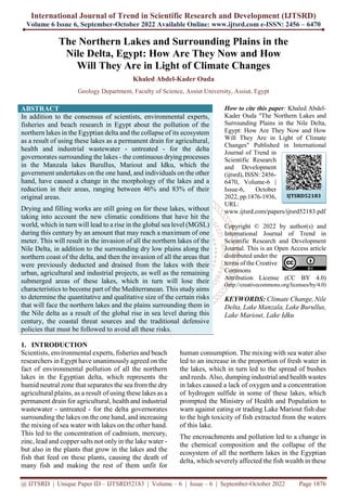
- 4. International Journal of Trend in Scientific Research and Development @ www.ijtsrd.com eISSN: 2456-6470 @ IJTSRD | Unique Paper ID – IJTSRD52183 | Volume – 6 | Issue – 6 | September-October 2022 Page 1879 experts have also agreed in the IPCC reports that there is strong evidence that current policies to reduce carbon emissions will not be able to reduce these emissions over the next dozens of years. The emission of carbon dioxide gas will increase in proportion to the air by between 25-90% during the period from 2000 to 2030 and thereafter. And that the continuation of these emissions threatens to further global warming in the twenty-first century, at rates greater than what it was in the twentieth century. All the scientific reports issued by the United Nations organizations (the Intergovernmental Authority on Climate Change “The World Bank, the United Nations Environment Program)” and scientific non- governmental organizations, universities, Egyptian and international research centers and news agencies have unanimously agreed that the Egyptian Delta is considered one of the most threatened sites bymarine invasion as a result of the increase in global sea level. These risks combine with the side effects left by the construction of the High Dam to make the delta in imminent and certain danger. The situation is, thus, dangerous and requires quick treatment, and any delay means more losses. The threats arising from these risks will persist for several decades and perhaps for a few centuries, even assuming the success of the United Nations in stabilizing the concentration of greenhouse gases in the atmosphere in the near future. This is due to the fact that the Earth's climate system needs centuries to stabilize. On the other hand, the current international policies adopted to reduce the rate of emissions of these gases will not be able to reduce these emissions during the next tens of years. Added to these threats is the continuous increase in water poverty rates due to the increase in population growth rates and agricultural projects on the one hand, and the instability of fresh water resources available in Egypt on the other hand as a result of the construction of the Ethiopian Renaissance Dam and its severe impact on the amount of Nile water coming into Egypt. As well as the current environmental deterioration that afflicts the dry and wet coastal lands of the delta as a result of the river stopping pumping silt in front of the coast of the delta following the construction of the High Dam on the one hand, and unguided human activities on the other. The present research deals with the study of the topography and geomorphology of the four northern lakes of the Nile Delta in Egypt (Al Manzala - Burullus - Mariout - Idku), the surrounding plains, and their belts separating them from the Mediterranean Sea. (Figs. 1a and b), with a comparison of the areas of these lakes now with what they were about seventy years ago, and how these lakes will be and the plains around them if the global level of sea level increases as the most important sequential effect of the climatic changes that the world is witnessing during this century. Hence, this study aims to determine the quantitative and qualitative size of the risks that will face the northern lakes and the surrounding plains in the northern, northeastern and northwestern part of the Nile Delta as a result of the global rise in sea level during this century, the coastal threat sources and the traditional defense policies that must be followed to avoid all these risks. The current study is based on the consideration that the maximum remainder increase in the global average sea level (GMSL) during the twenty-first century is 100 centimeters, based on the sixth report issued by the Intergovernmental Panel on Climate Change (IPCC), and the supplements published concurrently with it in December 2019-2021. As for what was mentioned in the scientific report of the World Bank directed to developing countries (Dasgupta, 2007) that the maximum sea level rise during this century could reach 300 centimeters, or what was mentioned in a study of the European Environment Agency (2021) that the rapid disintegration of the ice cover in Antarctica may lead to a sharp rise in the global sea level to 2.3 meters in 2100 - we don't work with it. Such a sharp increase in sea level is not expected by the Intergovernmental Panel to occur in this century, but rather during the next two or three centuries as a long-term effect of climate change - due to the greater ice loss expected from the Antarctic ice sheet. This is if emissions are not controlled so that the concentration of carbon dioxide in the atmosphere reaches 660-790 parts per million. 2. Methods of Study In this study, modern international mapping programs have been used, the most important of which is the Global Mapper (versions 9-13) program to design detailed topographic and contour maps of the delta coasts and to determine the damaged and safe areas in relation to sea level based on the information and digital data for ground elevations received from the Shuttle Radar Topographic Mission (SRTM) of NASA. This shuttle has built a high-resolution World-Wide Elevation Data (3-arc- second Resolution) system for most of the Earth's land surfaces. The fourth improved version of this information released in 2008 by CGIAR-CSI was used. The current human uses of the threatened lands in question have been determined through precise and
- 5. International Journal of Trend in Scientific Research and Development @ www.ijtsrd.com eISSN: 2456-6470 @ IJTSRD | Unique Paper ID – IJTSRD52183 | Volume – 6 | Issue – 6 | September-October 2022 Page 1880 direct electronic projection of modern satellite images on topographical maps designed with high accuracy. Worldwide high resolution color imagery from Digital Globe, and satellite images from Landsat 7, Bing Map, Google Earth Pro, and Google Maps were used. Also, GIS programs available to determine locations were used, such as The USGS Digital Elevation Model (DEM), USGS digital Raster Graphic (DRG) data, USDA National Agriculture Imagery Program (NAIP), Digital Chart of the World, Egypt. This is in addition to field visits to some threatened neighborhoods along the northern coast of the Nile Delta and its beaches. This study included detailed topographic maps of the northern lakes of the Nile Delta (Al-Manzala, Burullus, Mariout, Idku) in their current condition in order to compare them with what they were in the early fifties, and then put them in the case of sea level rise; maps of short heights and colors to show the boundaries of the threatened lands in relation to the current and prospective sea level, and the sources of their threat; the satellite images corresponding to these topographic maps, represented by the lines of the new beach in the event of sea level rise, the threatened lands and their areas, and the sources of their threat; the effect of sea level rise on human uses of threatened land spaces, in order to determine the size of the gaps that permeate the coastal threat sources in order to determine the appropriate means of protection and the specifications of defense lines. Fig 1a: Detailed topography of the Nile delta as it is the present status (after Ouda, 2010, 2011). The white lines are the boundaries of the natural delta that separate it from the desert back on both sides of the delta. The total area of the delta within these borders is 24450.0 square kilometers, extending from the Tina plain in the east to the coasts of Alexandria in the west (from Abu Qir in the north to Agamy in the south), and from the sea in the north to the west of Greater Cairo before the river branch begins directly in the south. Note that the eastern extension of the delta towards Ismailia and the Bitter Lakes falls within the natural delta range according to what was mentioned in the ancient maps before the Islamic conquest and during the Fatimid and Ayyubid eras (see the Atlas of the History of Islam - Hussein Munis 1987). The surface of the delta descends gradually from less than 20 meters above sea level at south to below zero level (below sea level) at north. The delta includes, from north to south, an area of ~ 4400 km² situated topographically below sea level, equivalent to 18% (blue area), ~7000 km² of surface level ranging from sea level (0 meter) to 3.0 meters above sea level, equivalent to 28.6% (yellow areas), ~3600 km² of surface level ranging from more than 3.0 meters to 5.0 meters above sea level equivalent to 14.7% (light green areas), ~5700 km² of surface level ranging from more than 5.0 meters to 10.0 meters above sea level, equivalent to 23.3% (red areas), ~3660 km² surface level ranging from more than 10.0 meters to 20.0
- 6. International Journal of Trend in Scientific Research and Development @ www.ijtsrd.com eISSN: 2456-6470 @ IJTSRD | Unique Paper ID – IJTSRD52183 | Volume – 6 | Issue – 6 | September-October 2022 Page 1881 meters above sea level equivalent to 14.9% (black areas), then sporadic 90 km² of surface level situated more than 20.0 meters above sea level equivalent to 0.4% of the total area of Delta. Fig. 1b: A brief topography of the Nile Delta as it stands, showing the locations and areas of the northern lakes Manzala, Burullus, Idku and Mariout (with continuous white lines) as they currently appear as they currently appear in relation to the total area of the delta. The white dashed lines are the boundaries of the natural delta. The black areas are elevated above sea level with a maximum of 20.0 meters. The blue areas within the delta borders are the dry (2790 km²) and wet areas (1031 km²) whose level is less than sea level. 3. Results and Discussion 3.1. The current situation of the northern lakes in the Egyptian delta, compared to what it was in 1949 3.1.1. The Manzala Lake The Lake Manzala, the largest of the Egyptian lakes, has reduced its geographical area from 1797 km² in 1949 (according to cadastral maps in 1949, Fig. 2a) to 1200 km² in 1980, after draining large areas south and east the lake. Currently, the area occupied by the lake borders is 850 km² (Fig. 2b) after separating the southern part used as a general sewage complex coming from Cairo and the neighboring governorates of the lake (Bahr al-Baqar, Bahr Hados, Faqous and other drains,). This area does not reflect the reality of the lake from the inside, as the lake was subjected to drying operations for the purpose of constructing roads and public utilities. Areas of them were also deducted and isolated as private basins by individuals for the purpose of establishing random fish farms, in addition to sand dunes, dry marsh sediments, residential villages and dry lands whose level rises above sea level. By measuring the dry and dried areas within the current Manzala lake borders, it was found that they are about 350 km², while the boundaries of the water basins do not actually exceed 500 km², of which about 455 km² are already submerged, and the remaining 45 km² are roads, bridges and dry paths that intersect the water basins (Figs. 3a-b). If we add the area currently submerged in the public sewage complex south of the lake, which is approximately 22 km², then the total area currently submerged in Lake Manzala is 477 km². And after the lake was overlooking five governorates, it became confined between the governorates of Port Said and Damietta. Human activity is concentrated east of Lake Manzala, along the west bank of the Suez Canal, south of the lake, and northwest of the lake near Damietta. It is worth noting that about 30% of the area of the lake has been drained to allow the Salam Canal to pass through it to deliver fresh water to the Sinai - despite the lake having been declared as a nature protectorate since 1988.
- 7. International Journal of Trend in Scientific Research and Development @ www.ijtsrd.com eISSN: 2456-6470 @ IJTSRD | Unique Paper ID – IJTSRD52183 | Volume – 6 | Issue – 6 | September-October 2022 Page 1882 The current topography of the lake can be distributed through satellites and the application of the international mapping program as follows: 68 km² of dried lands and dry marsh sediments, the level of which does not exceed sea level. 152 km² of dry lands with a level ranging from more than zero to one meter above sea level 175 km² of dry land partially covered by sand dunes whose level rises more than one meter above sea level 455 km² is already submerged below sea level, in addition to 22 km² in the public sewage complex south of the lake (Figs. 3a and b) The lake is isolated from the sea in the north by a belt of sand dunes that is not homogeneous topographically in terms of the latitudinal extension, the level of the sand dunes, the nature and size of the inter-depressions. This belt extends along the northern coast of the lake, east of the Nile River, in an east-west direction, with a length of 7.6 km, and then deviates sharply in a southeast direction until Port Said, with a length of about 44 km (Figs. 4a- b and 5a). The width of the belt ranges from 0.8 km to 4.75 km, with an average range from 1.7 km to 2.8 km. The area of the southeast/northwest belt of the lake is about 109 km² (Figs.5b-f), of which 33 km² (30% of the total belt area) does not exceed sea level (zero), 24 km² (22%) ranges between zero and one meter above sea level, also 24 km² (22%) is more than one meter and does not exceed two meters above sea level, and the rest of the area (28 km², or 26%) is more than two meters above sea level, with a maximum of 6 meters above sea level. The belt, south of the shore line, parallel to the coast, is interspersed with submerged depressions of varying latitudinal and longitudinal extensions that act as lakes and sub-pools of the main lake and are connected to it through channels and transverse corridors. The western part of the southeastern belt of the lake known as Barr al-Dahra (west of al-Manasra village) constitutes the largest part of the belt area (about 75 km²). It consists of intermittent longitudinal semi-parallel chains of sand dunes ranging in level between +1 and +6 meters, and the majority of their area does not exceed 2 meters above sea level. These dunes extend longitudinally parallel to the beach line, and many submerged depressions are confined between them, representing about 30.7% of the area of this part of the belt (Figs. 5b and 5c). These depressions converge and intersect in the south at Manama Al-Sheikh Ali (south of the Coast Guard Point Al-Halq), where the migratory dune chains from the north and northwest lose their extension and decrease in density. The inter-depressions expand, which in turn forms a large sub-lake connected to the main lake (the Maidan). This lake is separated from the sea only by a dilapidated belt of scattered and intermittent sand dunes, whose level does not exceed 2 meters above sea level, and is interspersed with many gaps that serve as corridors between the sea and the lake, with a level ranging between zero and -5 meters below sea level. These gaps are spread along the coast extending from Manama Al-Sheikh to Al-Ashtum Al-Jadid (south of the coastal deflection guard point) with a length of 7.2 km. This part of the coast represents the most dangerous parts along the coast of Lake Manzala and threatens to rush sea water into the lake in case the sea level increases byan amount ranging from 50 cm to a meter. There are also some gaps along the coast extending from Manama Sidi El-Gendyto the middle of the Al-Shenka pond northwest of Al-Manasra village, in which the beach dunes sometimes rise to about 6 meters above sea level, but these gaps (about 2.1 km long) represent a threat to the pond Al-Shenka, which lies south of the beach line, and then Lake Manzala, if the sea level rises by no less than a meter (Figs.5d and 5e). Noting that in the event of an increase in the sea level by a meter, the sea water will sweep about 59% of the coastal sandybelt that forms what is known as the Barr al-Dahra, which extends northwest from the village of Manasra to the northern border of the lake, with a length of about 23 km. It is clear that the disintegration of the sand belt and the decrease in its level along the Barr al-Dahra is due to the continuous migration of sand dunes from the northwest to the southeast, with not being compensated by new sediments that migrate to them from the mouth of the river Damietta branch as a result of the river losing its load after the construction of the High Dam, which increased, in turn, rate of beach erosion. It is noted that there are chains of sand dunes (Bur Al-Hamar, Bur Al-Raml and Bur Sidi al-Baghdadi) that cut across the Manzala Lake itself in several locations, extending from near the mouth of the river to the interior of the lake in a southeast direction, parallel to the coastal chains, until it intersects with the latter south of the Shenka pool (Fig.5e). As for the eastern part of the belt extending from Al-Shenka pond to Port Said, it has an area of about 34 km², and it seems more coherent and tight, despite its reduced width than it is in the Barr al-Dahra (Fig.5f), despite the fact that depressions and submerged basins occupy an area equivalent to 29% of its total area. The reason for this is that the sand dunes are a tight longitudinal chain along the shoreline with a height of 3 m to 8 m above surface level, while the depressions and submerged basins limit the dunes to the south. These depressions and basins are supported by industrial structures, as this part of the coastal strip extending east from Sidi Mohamed El Maghribi
- 8. International Journal of Trend in Scientific Research and Development @ www.ijtsrd.com eISSN: 2456-6470 @ IJTSRD | Unique Paper ID – IJTSRD52183 | Volume – 6 | Issue – 6 | September-October 2022 Page 1883 to Port Said is characterized by human, tourist, industrial and residential activity (Fig.4a). This activity has contributed to changing the morphology of this part of the sand belt and the beaches overlooking the sea. Fig.2a: A brief topography of the northeastern coastal part of the Nile Delta, showing the boundaries of Lake Manzala (marked by yellow lines) according to the cadastral maps in 1949. The total area of the original lake was 1797 square kilometers, including the sandy belt separating the lake from the sea, and not including the submerged areas at the bays or small separate ponds in the governorates of Dakahlia and Sharqia. The black areas are dry lands whose level rises above sea level up to 20 m, while the blue areas are below sea level. Fig. 2b: Brief topography of the northeastern coastal part of the Nile Delta, showing the current boundaries of Lake Manzala (yellow lines) after draining additional areas. The part located south of the lake is the remaining part of the sewage complex coming from Cairo and the neighboring governorates (Bahr al-Baqar, Bahr Hados, Faqous and other drains). From now and ongoing, the geographical north is directed north of the picture.
- 9. International Journal of Trend in Scientific Research and Development @ www.ijtsrd.com eISSN: 2456-6470 @ IJTSRD | Unique Paper ID – IJTSRD52183 | Volume – 6 | Issue – 6 | September-October 2022 Page 1884 Fig.3a: Topography of the coastal strip of the current Lake Manzala - as it is in the current situation. Black areas are dry or drained lands whose level rises up to 20 meters above sea level. Blue areas are flooded, dry or drained lands below sea level. The yellow line represents the current general boundary of the lake. The red lines are the boundaries of the current water basins within the general boundaries, which represent about 59% (about 500 km²) of the general area of the current lake (850 km²). The interstitial areas that permeate the water basins are marsh deposits, sand dunes, roads and public utilities, representing about 41% of the general area of the lake. Note that the water basins are also interspersed with 45 km of sand dunes whose level rises above sea level, Fig. 3b: Satellite image of the northeastern coastal part of the Nile River Delta, showing the development of the current Lake Manzala from 1949 until now. The white areas are the areas that have been drained from the original Manzala Lake from 1949 until 1990. The red areas are the dry natural areas inside the lake, in addition to the areas that have been drained and exploited inside and outside the lake since 1990 until now. The black ground areas are the wet areas exploited from the lake for sewage coming from the neighboring governorates of the lake.
- 10. International Journal of Trend in Scientific Research and Development @ www.ijtsrd.com eISSN: 2456-6470 @ IJTSRD | Unique Paper ID – IJTSRD52183 | Volume – 6 | Issue – 6 | September-October 2022 Page 1885 Fig. 4a: A brief topography of the coastal strip of Lake Manzala, which extends on the Mediterranean coast between Port Said in the east and Ezbet Al-Burg in the west - if the sea level increases by one meter, showing on them the locations of the low gaps (yellow circles) that cut through the sandy belt of Lake Manzala, which in turn will serve as waterways between the sea and Lake Manzala and the dry and dried plains that surround them. Note the small gaps that cross the eastern bridge of the Nile, the Damietta branch, between Damietta and Ezbet El Burg, which will work also as waterways assisting the flow of water from the lake to the Nile River. The black areas are dry lands whose level rises more than a meter above sea level, while the blue areas are submerged and dry or dried low lands, their level ranges from - 7.5 meters below sea level to one meter above sea level. The numbers next to the circles are the radii of the holes. Fig. 4b: A brief topography of the coastal strip extending on the Mediterranean coast between the governorates of Port Said in the east and Daqahlia in the west - if the sea level increases by one meter, explaining on it the locations of the low-lying gaps that permeate the sandy belt of Lake Manzala and the western bridge of the Suez Canal, which in turn will serve as water passages between the canal on the one
- 11. International Journal of Trend in Scientific Research and Development @ www.ijtsrd.com eISSN: 2456-6470 @ IJTSRD | Unique Paper ID – IJTSRD52183 | Volume – 6 | Issue – 6 | September-October 2022 Page 1886 hand, and Lake Manzala and the dry and dried plains that surround it on the other. The yellow line represents the borders of the lands threatened by sea invasion. Figs. 5a & b: Detailed topography of the northern sandy belt (Fig. 5a) and the northwestern-southeastern sandy belt (Fig.5b) of Lake Manzala on the Mediterranean coast - if the sea level rises by a meter. The white line is the current beach line. Note the spread of in-between gaps (red circles) along the shoreline in both the northern and northwestern-southeastern belts, especially in the area known as Barr Al-Dahra (Fig. 5b). These depressions will serve as sea lanes between the sea and Lake Manzala in case the sea level rises. Figs. 5c-e : A brief topography of the northwestern-southeastern sandy belt of Lake Manzala (the northwestern part of Barr Al-Dahra, Fig. 5c, the southeastern part of Barr al-Dahra northwest of Ezbet Shalaby Al-Rawdy, Fig. 5d, and the southeastern part of the belt extending from Ezbet Shalaby Al-Rawdy in the west to Al-Manasra village in the east, Fig. 5e,) – showing the location of gaps (yellow circles) that crosses the belt and which in turn will serve as sea lanes between the sea and Lake Manzala when the sea level rises to a maximum of one meter. The black areas are dry lands whose level rises more than a meter above sea level. The blue land areas are the submerged and drained areas of Lake Manzala and its related ponds, the level of which is below sea level (-3.0 m – -5m with a maximum of-15.0 m below sea level). The red areas are dry lands whose level rises above sea level by a maximum of one meter above sea level. The white patches are areas of unknown heights with satellites. Fig. 5 f: Detailed topography of the southeastern sandy belt of Lake Manzala extending from Al-Manasra village in the west to Port Said in the east along the coast of the Mediterranean Sea - if sea level rises by a meter. Note the existence of a continuous series of high sand dunes (from 3.0 meters to 7.0 meters and a maximum of 10.0 meters above
- 12. International Journal of Trend in Scientific Research and Development @ www.ijtsrd.com eISSN: 2456-6470 @ IJTSRD | Unique Paper ID – IJTSRD52183 | Volume – 6 | Issue – 6 | September-October 2022 Page 1887 sea level) extending directly south of the shore line and acting as a tight buffer between the sea and Lake Manzala. For legend see Figs.5a & b. 3.1.2. The Burullus Lake Lake Burullus extends along the northern coast of the delta in a northeast/southwest direction, where its current borders start from about 12 km east of Rosetta to Baltim in the east, with a length of 47 km and a width ranging from 5 km to 12 km. The lake has undergone a morphological change from the north, west and south as a result of human activity from drying and exploitation. Its area was reduced from 869 km² in 1949 (according to the cadastral maps issued in the same year, Fig.6a) to 466 km² as a result of human activity from drying and exploitation, of which 394 km² are already submerged areas and the rest are sabkha deposits, sand dunes and islands (Fig. 6b). Bushes and reeds are widespread in the flooded areas, especially the eastern part. Drying and filling operations were concentrated along the northern, southern and western shores of the lake for the purpose of establishing fish farms, and exploiting the sand dunes on the shores to grow crops and vegetables - although the lake has been declared a nature protectorate. The current topography of the lake is distributed as follows: 394 km² of submerged lands below sea level, of which about 151 km² are interspersed with sediments of sabkha, weeds and reeds (Figs. 7a and 7b). 57 km² of dry land and swampy sediments inside the lake whose level ranges from more than zero to one meter above sea level. 15 km² of dry land and sand dunes inside the lake whose level rises more than one meter above sea level. The lake is separated from the sea by a loose belt of sand dunes that extends from Kom Mishaal in the west to the Burg in the east in a northeast-southwest direction, with a length of about 41 km, a width ranging from 700 meters to 5.5 km, and a total area of about 115.5 km². The gaps whose level is below sea level down to -5.0 meters, which permeate the belt, constitute about 44% of the belt area (Figs. 8a and 8b). The sand dunes that make up the belt have undergone a great natural morphological change due to coastal erosion processes and the continuous migration of the dunes towards the lake due to air currents, in addition to human activity. The erosion of the dunes or their migration is no longer compensated by any new sediments migrating to them from the side of the Rashid estuary due to the river losing its load since the establishment of the High Dam. Thus, the sand dunes lost their cohesion, their level decreased, and the low gaps between them whose level is less than sea level between the sand dunes whose level does not exceed 3 meters widened in the greater part of the length of the belt. This has greatly contributed to the increase in the salinity of the lake and the change in its ecological composition and fishing system as a result of the intense rush of tidal currents that penetrate the lake daily. Sand dunes whose level does not exceed one meter above sea level occupy 23% of the belt area, and sand dunes whose level does not exceed 2.0 meters above sea level 18.6% of the total area, while the remaining 14.45% is occupied by sand dunes more than two meters above sea level. These dunes are distributed throughout the part extending between Kom Mishaal and Tell Magluba. Hence, the total area threatened by the sea invasion in case the sea level rises by a maximum of one meter is about 67% of its total area, through 12 gaps directly connected to the sea, their diameters range from 500 meters to 5000 meters, with a total length of 16.9 km, which is equivalent to 41% of the length of the belt (Figs. 8a and b). This is in addition to the huge gap that extends across the coastal sandy belt between the Green Island and Kom Mishaal, with a length of 13.5 km (Figs. 9a and 9b). All of these gaps, which are about 30 km long, will serve as wide sea lanes between the sea in the north and Lake Burullus in the south, and from there to the surrounding low plains. Hence, it can be said that the coastal sandy belt extending between the Green Island in the west and the Burg in the east, with a length of about 55 km, is the main source of threat to the wet and dry low plains in the northern delta, where the level of this belt does not exceed sea level by 47.4%, and does not exceed one meter above sea level by 73.4%, and does not exceed two meters at a rate of 88.3% of its total area, which is about 175.5 km² (Fig. 8a). While the rest of the belt area (11.7%) contains sand dunes whose level ranges from more than 2.0 meters to 10.0 meters above sea level. As for the low gaps that permeate the belt (Figs. 10a-f), whose level ranges from -5 meters (and a maximum of -7.5 meters) below sea level to one meter above sea level, their diameters range from 500 meters to 13.5 km (the great gap that characterizes the western extension of the belt west of Kom Mishaal to the green island north of Rashid, Figs. 10b), with a total length of about 30.0 km. Hence, about 55% of the belt’s length is threatened by the transformation into wide sea lanes between the sea and the wet and dry southern plains, and that 73.4 percent of the total area of the belt is threatened by direct invasion from the sea if the sea level rises by a maximum of one meter. This matter threatens to invade Lake
- 13. International Journal of Trend in Scientific Research and Development @ www.ijtsrd.com eISSN: 2456-6470 @ IJTSRD | Unique Paper ID – IJTSRD52183 | Volume – 6 | Issue – 6 | September-October 2022 Page 1888 Burullus and the dry (or dried) low plains that surround it to the east, west and south in the north of Kafr El- Sheikh Governorate, including the original lands of the lake that have previously been drained or exploited - unless the necessary defense measures are taken. As for the sand belt that cuts between the sea in the north and the Green Island-Burg Mughaizel in the south (east of the Rashid estuary), it has an area of about 10 km², of which 6 km² does not exceed zero (sea level); some of them are already submerged (Al-Ghalyoun ponds, Al-Wastaniya, Al-Shaqaqi and Al-Mitah ponds), and others are dry or dried; and 3 km² whose level ranges between zero and one meter above sea level, and the rest of the area (1.0 km²) is covered by sand dunes whose level ranges between one and two meters above sea level. This means that the entire length of the belt (5.5 km) will be invaded by 90% of its area if the sea level rises by a meter (Fig. 10a). Thus, the current weak areas that are below sea level in the sandy belt extending from Lisan Rashid to the Burg constitute about 47% of its total area and about 53% of its total length, which threatens to invade the sea for half of the belt and from it to Lake Burullus and the low plains located south and east the lake. In fact, the vast majority (about 62%) of the dry or drained lands extending south, east and west of Lake Burullus, north of latitude 30⁰ 18.75’ and between longitudes 30⁰ 33.75’ and 31⁰ 3.75’, with an extension southeast to Hamoul, and northeast to Baltim village, west to Rashid, and southwest to Sindion on the eastern bank of the Nile - are low lands whose level ranges between -4 meters below sea level and one meter above sea level. In contrast to the sand belt that separates Lake Burullus from the sea, the sand belt extending from Burg (the far northeast of Lake Burullus) in the west to Gamasa in the east is considered one of the strongest natural defenses that prevent the sea from invading this coast long ago, except for the seasonal inundation of some sites. The coast extending for about 60 km in a southeast/northwest direction between Burg in the east and Gamasa in the west is distinguished from the coastal areas of the Burullus and Manzala lakes by the presence of dense fields of sand dunes (440 km²). that act as a belt parallel to the beach graduating in the transverse extension south of the beach from 1.0 km in the west (at the Burg) to 11 km east (at Gamasa), with an average of about 7 km (Fig. 11). Although there are many inter-depressions interspersing these dunes longitudinally below sea level, but there are no lakes along this coast. The disappearance of lakes from this area from the coast of the delta is due to the continuous deposition of sand dunes, which since 3000 BC covered a large area of this area (Stanley et al., 1992). The sedimentation rates of these dunes exceeded the combined rates of delta subsidence and global sea level rise during this period. This led to the accumulation of dunes that form a continuous, coherent and wide topographical ridge between the Burg in the west and Gamasa in the east, as this line acts as a natural impenetrable dam that prevents the continuation of a waterwaybetween the sea and the inter- depressions, which prevents the sea from invading these depressions, and thus prevents the formation of permanent lakes. As for the tourist cities overlooking the sea along the coast extending from the tower in the west to Gamasa in the east, their beaches will be exposed to direct invasion from the sea to varying degrees, as most of the beaches of these cities are artificial beaches completely cut off from the sea (Gamasa Resort) or it was expanded at the expense of the sea (Baltim Resort) instead of the natural beaches that were partially or completely eroded. The beaches of the Baltim Resort are threatened by 50% of its total area (Fig. 11), while the beaches of Gamasa are threatened with a complete invasion of 100% (Fig. 12) unless the level of these beaches is raised more than a meter by throwing sand on them. As for the cities themselves, they are safe from the invasion of the sea because their levels range from 4.0 to 8.0 meters above sea level.
- 14. International Journal of Trend in Scientific Research and Development @ www.ijtsrd.com eISSN: 2456-6470 @ IJTSRD | Unique Paper ID – IJTSRD52183 | Volume – 6 | Issue – 6 | September-October 2022 Page 1889 Fig. 6a: A brief topography of the northern coastal part of the Nile Delta as it is in the current situation, with the boundaries of Lake Burullus indicated according to the cadastral maps in 1949. The total area of the original lake (the area marked with yellow lines) is approximately 869 square kilometers, without the sandy belt separating the lake from the sea. Black areas are dry lands whose level rises above sea level. The blue areas are wet, dry or dried lands whose level is below sea level to -3.0 meters (and a maximum of -7.5 meters). Fig. 6b: The same topography of Fig. 6a showing the current borders of Lake Burullus according to satellite images and information amounting to 466 square kilometers, which is equivalent to about 54% of the original area of the lake. Of this area, 394 square kilometers are submerged under sea level, and the remaining 72 square kilometers are dry marsh deposits that permeate the lake, sand dunes and lands whose level rises above sea level.
- 15. International Journal of Trend in Scientific Research and Development @ www.ijtsrd.com eISSN: 2456-6470 @ IJTSRD | Unique Paper ID – IJTSRD52183 | Volume – 6 | Issue – 6 | September-October 2022 Page 1890 Fig. 7a: A brief topography of the northern coastal part of the Nile Delta as it is in the current situation, with the current borders of Lake Burullus (yellow lines) which has an area of about 466 square kilometers without the sandy belt separating it from the sea, including submerged areas under sea level of 394 square kilometers, and the rest of 72 square kilometers are dry marsh sediments permeating the lake, sand dunes and lands whose level rises above sea level. The white areas are the areas that have been drained since 1949 until now. Note that there are other small areas drained southeast and east of the lake, which confirms the existence of previous extensions of the lake before 1949. Fig.7b: Satellite image of the same northern coastal part of the Nile Delta, given its topography in Fig.7a.
- 16. International Journal of Trend in Scientific Research and Development @ www.ijtsrd.com eISSN: 2456-6470 @ IJTSRD | Unique Paper ID – IJTSRD52183 | Volume – 6 | Issue – 6 | September-October 2022 Page 1891 Fig. 8a: A brief topography of Lake Burullus and the sandy belt separating it from the sea - when the sea level rises to a maximum of one meter, showing the locations of the low-lying gaps (red circles) that permeate this belt, which will serve as sea corridors between the sea and the dry and submerged lowlands south of the belt. The white line is the current beach line. The yellow line represents the current boundary of Lake Burullus. The blue land areas are depressions less than a meter above sea level until -5.0 meters (and a maximum of -7.5 meters near the shore line) below sea level, Black areas are lands that rise a meter or more above sea level. Fig. 8b: Satellite image of the same coastal belt whose topography is given in Fig. 8a, showing on it the locations of the low gaps (yellow circles) that permeate this belt.
- 17. International Journal of Trend in Scientific Research and Development @ www.ijtsrd.com eISSN: 2456-6470 @ IJTSRD | Unique Paper ID – IJTSRD52183 | Volume – 6 | Issue – 6 | September-October 2022 Page 1892 Fig. 9a: Detailed topography of the sandy belt extending from the Green Island (north of Rashid) in the west and Kom Mishaal in the east along the Mediterranean coast - when the sea level rises to a maximum of one meter, showing the locations of the low gaps (red circles) that permeate the belt along the shoreline and which in turn will serve as sea lanes between the sea and the dry and flooded lowlands south of the belt (the blue areas). The white line is the current beach line. Note that the sand dunes that permeate the depression do not exceed an average of 2.0 meters above sea level, and therefore this coastal part of the belt is considered one of the most dangerous parts that threaten to invade the sea for all the lowlands located south of the shore line between Lake Burullus and the River Nile. Fig. 9b: Satellite image of the same sand belt whose topography is given in Fig. 9a.
- 18. International Journal of Trend in Scientific Research and Development @ www.ijtsrd.com eISSN: 2456-6470 @ IJTSRD | Unique Paper ID – IJTSRD52183 | Volume – 6 | Issue – 6 | September-October 2022 Page 1893 Fig. 10a-f: Detailed topography of the sandy belt of Burullus Lake that extends from the mouth of the River Nile, the Rosetta branch at west to Al Burg at east if the sea level rises to a maximum of one meter. The white lines is the current beach line. The red circles mark the location of gaps cutting through the sandy belt and which in turn will become sea lanes between the sea in the north and low southern plains surrounding the Burullus Lake. Fig. 10a: The sang belt which separates the Green Island - Burg Mughaizel (North Rashid) from the sea along the Mediterranean coast. Note the general deterioration of the sand belt north of the Green Island - Burg Mughaizel, and this belt turned into large wet depressions ranging from -3,0 meters below sea level to one meter above sea level. Fig. 10b: A brief topography of the sandy belt extending from the Green Island (north of Rashid) in the west and Kom Mishaal in the east showing the collapse of the sand belt extending across the great gap (13.6 Km) which threatens to invade the sea all the low lands south of the shore line, whether submerged or dry, extending from Lake Burullus in the east to the Nile River in the west. The black areas are lands whose level rises more than above sea level, while the blue areas are low, submerged and dry lands ranging from -3.0 meters (and a maximum of -7.5 meters near the shore line) below sea level to one meter above sea level. Fig. 10c-f: Detailed topography of the sandy belt extending (north of Lake Burullus) from east of Kom Mishaal to Kom Mastrowa (Fig. 10c), from the east of Kom Mastrowa to the west of Tell El Maqluba (Fig. 10d) from Tell Al-Maqluba in the west to Al-Burg in the east (Fig. 10e) and from the Burg in the west to Al Khashousi in the east (Fig.10f) along the coast of the Mediterranean. Note that the effect is non-existent along the shore
- 19. International Journal of Trend in Scientific Research and Development @ www.ijtsrd.com eISSN: 2456-6470 @ IJTSRD | Unique Paper ID – IJTSRD52183 | Volume – 6 | Issue – 6 | September-October 2022 Page 1894 line from Al-Burg in the west to Al-Wahhabia in the east due to the rise in the ground level from more than a meter to 8 meters or more directly above the shore. Fig. 11: Panorama of detailed topography of the coastal strip of Baltim Resort on the Mediterranean coast between Burj in the west and Gamasa in the east when sea level rises by a maximum of one meter. The white line is the current beach line. Note that the southern depressions are isolated from the Baltim beach and summer resort by a longitudinal chain of high sand dunes (blue ground areas), and therefore they are safe from sea invasion, but the chances of being partially submerged by subsurface water increase if its level rises as a sequential effect of sea level rise. Fig. 12: Detailed topography of the coastal strip of Gamasa Resort on the Mediterranean coast - showing the effect of sea level rise of a maximum of one meter. The white line is the current beach line. The blue beach areas delimited by black lines south of the shore line are the areas threatened by direct inundation from the sea, and they include the entire Gamasa beach. Note that the city is safe from the invasion of the sea.
- 20. International Journal of Trend in Scientific Research and Development @ www.ijtsrd.com eISSN: 2456-6470 @ IJTSRD | Unique Paper ID – IJTSRD52183 | Volume – 6 | Issue – 6 | September-October 2022 Page 1895 3.1.3. The Idku Lake As for Idku Lake, it is a glaring example of illegal encroachment, as the area of the lake shrank from 129 km² in 1949 (Fig. 13a-b) to 64 km² in 1982, then to 21.5 km² south of Al-Labbani until the end of 2008 (Fig. 14a), meaning that about 83% of the original lake area had been drained (Fig. 14b). As a result of the appropriation of large areas by farm owners in violation of the law, as well as due to government negligence in clearing the lake, as about 50% of the current area is made of reeds, Nile roses and weeds. Although Idku Lake is separated from the sea from the north and northeastern sides by a strong belt of sand dunes whose level ranges from one to 20 meters above sea level - the western side of the lake is not separated from the southern coast of Abu Qir Gulf by any sandy belts, except for some dunes dispersed whose level does not exceed one meter above sea level (Fig. 13a). Therefore, the sea’s invasion of the southern coast of Abu Qir Gulf, when the global sea level rises by a meter, will lead to the invasion of the entire northwestern part of the Nile Delta until the Mahmoudiya Canal in the south, including what remains of Lake Idku. While the city of Idku is located on heights ranging between 2.5 and 15.0 meters, with an average of 6.0-7.0 meters above sea level, the city is bordered by a depression in the north (the Gulf side) that extends along the beach with a level ranging from – 7.5 meters (below sea level) and one meter above sea level, which is a depression that is partially flooded and seasonally, despite the drying up of large areas of it. The city is also bordered on the west by a narrow depression perpendicular to the coast with a length of 1.5 km and a level ranging between -2.5 and +1.0 meters. It is also bordered on the east by a wide depression with a length of 2.76 km, and a ground level ranging between -2.0 and +1.0 meters. In addition, the city is surrounded on the south by low plains below sea level, part of which is submerged (remnants of Lake Idku) on the southeastern side of the city, which threatens to isolate the city from all directions and threatens the southern expansions of the cityin the event of an increase in sea level by a maximum of one meter (Fig. 14b). The southern coast of the Abu Qir Bay is not only a source of threat to Lake Idku, as this lake is no longer what remains of it after drying and exploitation as fish farms, which can be considered of great economic value - but this coast is the main source of threat to all the dry and wet lowlands (Idku and Mariout lakes) located in the south of the Bay in Northwest Delta (west of the Rashid branch, Ouda, 2022)),. The sandy belt that separates the Bay from the southern plains between the Nile River in the east and the city of Alexandria in the west has been eroded not only by coastal erosion factors, but also by the population, industrial and educational activity that is concentrated on the coastal strip directly south of the Gulf between the suburb of Abu Qir and the village of Maadiyah. The topographical survey (Ouda, 2022) showed that this part of the Bay is a source of threat to all agricultural, residential and wet lands (remnants of the Idku and Mariout lakes) located in the south of the Gulf, which extends to the desert back in the south, between the Nile River - Damanhur in the east, and Alexandria in the west. The sandy coastal strip, which extends north of the Abu Qir-Maadiyah road and separates the sea from the low-lying plains to its south, which has an area of 6.1 km2, is low in level, and does not exceed one meter in height above sea level at 83% of its total area. As for the gaps below sea level (down to -4 meters below sea level) that permeate the coastal strip, they occupy about 66.6% of the total area of the strip, and about 50% of the length of the coastal strip. Many of these gaps have been filled for construction purposes to a level that does not exceed sea level. It is concentrated between Abu Qir and Al Mandara, between Al Mandara and Al Tarh, and between Al Tarh and Al Maadiyah along the coast. Accordingly, an increase in sea level by a maximum of one meter would cause the sea to invade the majority of the coastal strip extending between Maadiyah and the suburb of Abu Qir (Fig. 15a-b). Muhammad Ali's wall, which was built in 1830 in Abu Qir Bay in Alexandria, is not suitable for protecting the plains to its south. The wall is nothing but piles of stones that extend along the southern shore of the Gulf of Abu Qir that have no submersible under the soil to ensure that sea water does not seep through the subsurface soil in case the sea level rises. Also, its height is not enough to guarantee its protection from the rise in global sea level by a meter. The wall along its length is subjected to the invasion of high waves during hurricane seasons due to the high water levels during the tide, in a way that led to the flooding of the area with sea water many times, and the high waves led to collapses in many areas of the wall). The presence of leaks currentlyspreading on the coast directly south of the wall confirms the inability of this wall to repel severe waves if they rise for any reason of the local rise (such as severe storms and tsunami waves) as a result of the gaps and inter-holes spread in the wall ((for details see Ouda, 2022). Hence, the wear and tear of this wall, along with its inefficiency to counter the certain rise in the global sea level, will threaten the sea’s invasion of all the southern plains of the Gulf of Abu Qir, including the remnants of Lake Idku and the northeastern plains of Alexandria, extending south of the neighborhoods of Maamoura, Montazah, Mandara, and Sidi Bishr al-Qibli, where their level is all under Sea level usually ranges from -2.0 m to -5.0 m, with a maximum of -7.0 m (Fig. 15a).
- 21. International Journal of Trend in Scientific Research and Development @ www.ijtsrd.com eISSN: 2456-6470 @ IJTSRD | Unique Paper ID – IJTSRD52183 | Volume – 6 | Issue – 6 | September-October 2022 Page 1896 3.1.4. The Mariout Lake As for Lake Mariout, opinions differed about its original area during the past centuries after the extinction of the Nile branches feeding the lake and the drying up of large parts of it, but it is certain topography that the lake was, at the least, occupying an area of not less than 570 km² south of Alexandria before 1949 (Fig. 16a), as this area is less than its current level Sea level between -3.0 m and -8.0 m below sea level although large parts of it have dried. In 1949, cadastral maps showed that the lake occupies an area of 383 km² of which 268 km² is located south of the city of Alexandria and 115 km² is the western extension of the lake to the city of Al- Hammam (Fig. 16 a-b). Since this date, the lake has been drained, especially since 1986, under the supervision of the Egyptian government and the Governorate of Alexandria until it was torn to a number of isolated lakes with a total area of 63 km² south of Alexandria (Fig. 17a), in addition to the western extension of the lake to the city of Al-Hammam, whose area does not exceed 87 km², 13 km² of which are fish farms (Fig. 17b). This means that about 76.5% of the area of the lake south of Alexandria has been deducted and drained since 1986 until now, and about 36% of the area of the western extension of the lake for the purpose of urban development and agricultural reform. In an official report issued by the Ministryof Environment, about 3.28 km² was filled in by a direct order from the Prime Minister to establish a sports city, the international park, the expansion of the international road and the sewage project in Alexandria. Within the framework of the New Alexandria project, the designs of the project included filling in about 5.67 km² in the Abu Azzam and Al-Alayma basins with the aim of establishing an urban area to which the Smart Village is attached. Fig. 13a: Detailed topography of the northwestern coastal part of the Nile River delta - showing the boundaries of Idku Lake, according to cadastral maps in 1949, estimated at 129 square kilometers (black
- 22. International Journal of Trend in Scientific Research and Development @ www.ijtsrd.com eISSN: 2456-6470 @ IJTSRD | Unique Paper ID – IJTSRD52183 | Volume – 6 | Issue – 6 | September-October 2022 Page 1897 borders). Note that all previous and current lake areas are below sea level without sand dunes or significant high lands interspersed. Fig. 13b: Satellite image of the same northwestern coastal part of the Nile River delta whose topography is given in Fig. 13a. - Note the areas which have been exploited as fish farms and the sabkha deposits scattered around the borders of the current lake. Fig. 14a: Satellite image of the northwestern coastal part of the Nile Delta - showing the stages of Idku lake reduction. The white area represents the lake's borders in 1949 with a total area of 129 square kilometers. The blue areas represent the borders of the current lake with an area not exceeding 21.5 square kilometers. The reduction rate is estimated at 83%, while the remainder does not exceed 17% of the original area. Fig. 14b: Satellite image of the coastal strip extending between Tabiat El Gazayir in the south and Tabiat El Kalayem in the north along the eastern coast of Abu Qir Gulf - showing the effect of sea level rise of a maximum of one meter on land uses. The red areas north, east and north-east of Idku are the low plains threatened by direct marine invasion from the eastern coast of Abu Qir Bay, while the red areas south of Idku are the low plains threatened by direct marine invasion from the southern coast of Abu Qir Gulf through the wide gap (9 km) extending from El Maadiyah to the east To the suburb of Abu Qir to the west.
- 23. International Journal of Trend in Scientific Research and Development @ www.ijtsrd.com eISSN: 2456-6470 @ IJTSRD | Unique Paper ID – IJTSRD52183 | Volume – 6 | Issue – 6 | September-October 2022 Page 1898 Fig. 15a: A brief topography of the northwestern part of the delta extending from the River Nile, the Rashid branch in the east to Alexandria in the west, and from Abu Qir Bay in the north to Mahmoudia Canal in the south - if the sea level rose by a maximum of one meter, showing the location of the main source of threat along the coast of Abu Qir Bay between the suburb of Abu Qir in the west to the village of Maadiyah in the east (large yellow circle) and the smaller low-lying gaps that permeate the thin land strip extending along the length Mahmoudiya Canal between Abu Homs in the east and Alexandria in the west (small yellow circles), which will act as auxiliary sea lanes on the rush of the Gulf waters from the northern plains to the southern plains extending between the Mahmoudiya Canal in the north and the desert backwaters in the south. The blue areas are low, dry and wet lands, with a level ranging from -7.0 meters below sea level to one meter above sea level. Fig. 15b: A brief topography of the northwestern part
- 24. International Journal of Trend in Scientific Research and Development @ www.ijtsrd.com eISSN: 2456-6470 @ IJTSRD | Unique Paper ID – IJTSRD52183 | Volume – 6 | Issue – 6 | September-October 2022 Page 1899 of the Nile River delta (west of the Rosetta branch) when the sea level rises by a maximum of one meter - showing the locations of the coastal gaps (yellow circles) including the main gap on the southern coast of Abu Qir Gulf, the coastal gap extending between Wardyan and Dekheila along the Max Bay, and the small gaps that permeate the narrow land strip extending along the Mahmoudiya Canal between Abu Homs in the east and Alexandria in the west. Fig. 16a: Detailed topography of the western coastal part of the Nile Delta, which extends south of the city of Alexandria along the Mediterranean coast, explaining on it the borders of the previous areas of Lake Mariout in 1949 (blue areas), according to the cadastral maps issued at the time, where it occupied about 383 square kilometers, of which 268 square kilometers south of Alexandria from the entrance to Abis in the east to Abu Talat in the west, and 115 square kilometers is the western extension of the lake from Abu Talat to Al- Hammam along the northern coast. Note that the lake occupied vast areas in the northwest of
- 25. International Journal of Trend in Scientific Research and Development @ www.ijtsrd.com eISSN: 2456-6470 @ IJTSRD | Unique Paper ID – IJTSRD52183 | Volume – 6 | Issue – 6 | September-October 2022 Page 1900 the delta during ancient history when the city of Alexandria was established, but there are no documented maps that can be referenced. Fig.16 b: Satellite image of the same coastal part whose topography is given in Fig. 16a, explaining on it the previous and current borders of Lake Mariout. The white areas are the areas that have been drained and exploited from the original lake since 1949 until the present according to the cadastral maps issued at the time. The dark blue spaces represent the current remnants of the lake south of Alexandria, which is a number of stagnant ponds and isolated lakes with a total area of 63 km² (with the exception of the Nozha Airport and Airport Lake which were used before 1949), in addition to the western extension of the current lake from Abu Talat to Al- Hammam which assumes an area of no more than 87 km. Figs. 17a and b: satellite images of the coastal strip of the city of Alexandria, extending from the entrance of Apis in the east to Al-Hammam in the west on the Mediterranean coast- showing the areas occupied by the current Lake Mariout as it is now. The dark blue areas represent the current remains of the lake, which is a number of stagnant ponds and lakes isolated from each other south of Alexandria, with a total area of 63 km² (Fig. 17a), in addition to the western extension of the lake from Abu Talat at East to Al- Hammam at West, and its current area is 87 km² (not including the fish farms that permeate it, Fig. 17b),
- 26. International Journal of Trend in Scientific Research and Development @ www.ijtsrd.com eISSN: 2456-6470 @ IJTSRD | Unique Paper ID – IJTSRD52183 | Volume – 6 | Issue – 6 | September-October 2022 Page 1901 of which 75 square kilometers are submerged, and the rest is dry land permeating the lake. This means that about 60.0% of the area of the lake Mariout has been drained and exploited during the period from 1949 until now, and the drying operations are still going on. The western port of Alexandria is separated from the low lands south of Alexandria, which occupies some of its area, Lake Mariout (or what is left of it), a coastal strip with a width ranging between 650 and 1600 meters, extending from Al-Qabbari station in the east to Al-Agamy in the west. This strip consists topographically of discontinuous limestone hills ranging in height from 3 m to 10 m. These hills are interspersed with depressions representing ancient drainage channels whose level ranges from -6 meters below sea level to one meter above sea level. And the elevation maps show that the middle part of this port, which extends between Wardyan and El Max, and the middle-western part that extends between El Max and Dekheila, are the weakest parts of this coastal strip, and that they represent the second source after Abu Qir Gulf to threaten all the dry and wet lowlands that lie between southern Alexandria and Damanhur until the desert back, due to the gaps between Wardyan and El-Max with a length of 2 km, and east of Dekheila with a length of 1.1 km (Figs. 15b and 18). Some of these gaps extend from the shore line to Lake Mariout, south of the port. Most of these gaps have been filled and exploited by establishing industrial facilities. However, the decrease in its current level by a meter above sea level will expose the belt to a partial invasion in the event of a rise in sea level of one meter or more, as it constitutes about 24% of the total area of the lime belt extending between the Wardyan and Dekheila (4.4 km²), and it is concentrated in the part between Wardyan and El-Max, where it constitutes about 39% of the area of this part of the belt (2.0 km²). Fig. 18: A brief topography of the coastal strip of the western part of Alexandria, extending along the Gulf of El Max, from Qabbary in the east to Agamy in the west, including the Western Port and Dekheila Port when sea level rises by one meter. The white line is the current shore line. The yellow circle shows the location of the gap that permeate the limestone ridge that extends from Wardyan to Dekheila, especially between Wardyan and Al-Max which in turn will serve as sea passages between the sea and the southern plains. The blue areas, with their different shades, are the plains that are in danger of being invaded if the sea level rises. Thus, it can be said that if the southern coast of the Gulf of Abu Qir is the main source of threat to all lands north of Beheira governorate, including what remains of Lake Idku, and south of Alexandria governorate due to its topographical, geological and historical conditions that pave the way for the invasion of the sea in the event of an increase in the global sea level, the middle part of the Western Port, between Wardyan and Dekheila, comes
- 27. International Journal of Trend in Scientific Research and Development @ www.ijtsrd.com eISSN: 2456-6470 @ IJTSRD | Unique Paper ID – IJTSRD52183 | Volume – 6 | Issue – 6 | September-October 2022 Page 1902 as a second source of threat to the low plains located south of the Mahmoudiyah Canal, including what remains of Lake Mariout in case the sea level increases by not less than a meter, and not less (Ouda, 2022). The following table summarizes the topographical scales of the northern lakes - how they were and how they became. Table 1: The northern lakes of the Nile Delta: what were they like? and How are they now 3.2. Threats to the northern lakes and the surrounding low plains in light of climate change Based on the information and digital data received from the Shuttle Radar Topography Mission of NASA about the topography of the delta, and according to altimetry measurements using the Global Mapper program to design detailed topographic and contour maps of the Egyptian delta, it can be said that the increase in sea level by any amount greater than the current level will have dire consequences on the coasts of the Nile Delta. The delta is characterized by a continuous subsidence at its northern humid fringes, especially at the estuaries, and most of its northern parts do not exceed zero height, i.e. below sea level, with a depth inland ranging from 7.7 km to 58.5 km along the coast of the delta (Fig. 19). Therefore, the coasts of the delta are vulnerable to any rise in sea level, whether this rise is local or global. Although the local rise in sea level is limited in time and impact on the coasts of the delta, the global rise is long-term and has a great impact. A rise in this global level by a meter would sweep or submerge the dry and humid coastal lands that are lower than sea level and that are directly connected to the sea without being isolated from the sea by natural (or artificial insulators).or those separated from the sea by discontinuous chains of sand dunes with gaps between them. These lands are estimated to have an area of about 4001 km² (16.33% of the total area) at a minimum after excluding the threatened areas in the Tina Plain in the northwestern corner of the Sinai Peninsula. These lands include about 1031 km² of already submerged areas (the northern lakes of the delta currently, namely the lakes of Manzala, Burullus, Idku and Mariout, after human drying processes that affected large areas of them (Table 1), in addition to 2970 km² of dry areas extending along the northern coast of the delta (Table 2). These lands were separated from the sea by intermittent belts of sand dunes that represented natural barriers, their height ranged between 1.5 and 14 meters above sea level, and their width ranged between 1 and 10 km along the northern arc of the delta, which extends between Port Said in the east and Abu Qir in the west. These belts arose from the accumulation of river sediments of sand and silt, which the river carried through its long journey from the headwaters to the estuaries in Damietta and Rashid, and then the sea and air currents redistributed them along the coast. But the current problem is that these belts have been severely weakened, their areas have diminished, and the gaps between them have increased as a result of their lack of the flow of river sediments from sand and silt since the start of the work of the High Dam in 1969 on the one hand, and the
- 28. International Journal of Trend in Scientific Research and Development @ www.ijtsrd.com eISSN: 2456-6470 @ IJTSRD | Unique Paper ID – IJTSRD52183 | Volume – 6 | Issue – 6 | September-October 2022 Page 1903 continuation of the migration of the dunes due to the winds in the southeast direction on the other hand. The river's load is currently low to the point of nothing, and the transfer of river sediments to estuaries has become almost nothing. While the load of the river in 1964, before the closure of the river pass in front of the Aswan High Dam, ranged from 18 to 55 billion cubic meters annually of sediments, including the flood sediments, which amounted to 34 billion cubic meters. The river’s load of suspended sediments was estimated at 111 billion kilograms annually, 93-98% of which reached estuaries during flood seasons (Ouda, 2010). The interruption of river sediments after the construction of the High Dam contributed to the high rates of beach erosion along the northern arc of the delta. The delta outcrops inside the sea, which are called tongues, were eroded in both Rashid and Damietta. With a simple comparison between the topographical maps of the delta before the construction of the dam, and the maps designed on the basis of the information received by satellites today, it is clear that there is a wide morphological change that has occurred in both Lisan Rashid (Ahmed, 2002) Lisan Damietta (Al-Raey et al. 1999) and the sandy belts that separate the Burullus lakes from the sea, and those that separate the sea from the land in Abu Qir Bay (Ouda, 2010). The surface of the delta falls annually at unequal rates relative to its edges as a result of its skewed position. The northeastern side of the delta is lower than the northwestern side, declining at a rate of 5 millimeters annually, while the northwestern side is declining by 3 millimeters annually. As for the middle delta, the decline rate does not exceed 4.0 mm annually (Smithsonian Institution (1985), Stanley and others, 1992). The reason for this subsidence is the continuous pressure of sediments on the subsurface rocks as well as due to some ground Fig. 19: A brief topography of the Nile Delta if the sea level rises by a maximum of one meter - showing the borders of the plains in the northern part Nile Delta, which are threatened by direct invasion from the sea, or indirect invasion through the northern lakes. The white line is the normal delta boundary. The yellow lines are the general boundary of the threatened plains. The total affected area is 7303 km² (Table 2), representing 29.81% of the area of the delta, after excluding the Tina plain in northwestern Sinai, and the low areas not connected to surface water sources directly and could be threatened by partial inundation by subsurface water if its level rise as a sequential effect of sea level rise. The total affected area includes 5580 km² whose level does not exceed one meter above sea level, while the rest of this area, amounting to 1723², are cities, villages, dry lands and sand dunes whose level rises more than a meter above sea level but they will be besieged and isolated within the invaded areas. movements directed by faults. This continuous decline in light of the unloaded river increases the degree of salinity of the land, and also affects the groundwater, in addition to the consequences of the exposure of the
- 29. International Journal of Trend in Scientific Research and Development @ www.ijtsrd.com eISSN: 2456-6470 @ IJTSRD | Unique Paper ID – IJTSRD52183 | Volume – 6 | Issue – 6 | September-October 2022 Page 1904 coastal part of the delta to the invasion of the sea in the event of any local rise in sea level, even if the global sea level does not rise. If the area of 4001 km² is the minimum of wet and dry delta lands that are threatened with invasion if the global sea level rises by any amount more than the current level, then a rise of 100 centimeters in sea level, which is the maximum expected increase during the twenty-first century, will be sweeping wet and dry coastal lands with an estimated area of about 5580 km² along the northern arc of the delta from Port Said in the east to the suburb of Abu Qir in Alexandria in the west (Fig. 19). These lands do not exceed one meter above sea level. Hence, they do not include its interspersed cities, villages, roads, bridges, and sand dunes whose level is more than a meter above sea level, and which will be besieged and isolated within the invaded areas. The area of these lands is estimated at about 1723 km². Thus, the total affected areas in case of sea level rise by a maximum of one meter is 7303 km² (Table 2), representing 29.81% of the total area of the delta, after excluding the affected areas in the Tina plain in Sinai, and the low areas not connected to surface water sources directly and threatened by partial inundation by subsurface water Its level rise as a sequential effect of sea level rise. Fig. 20: A brief topography of the Nile Delta in case of rising sea levels by up to one meter - showing the locations of coastal gaps (yellow circles) along the northern sandy belt of the Delta from Port Said at east to Alexandria at west. The gaps are made up of 39 low-lying depressions ranging in diameters from 200 m to 13600 m. The ground level of these depressions ranges from below sea level to one meter above sea level, and thus would act as direct marine passages between the sea and the lowlands (dry and wet) lying south of the sea shore. In addition, there is a gap lying between Al Wardyan and El Dekheila along the Gulf of Max at Alexandria with a diameter of about 4000 meters, and which in turn would act as a sea corridor between the Gulf of Max and the low-lying plains south of Alexandria. Also, there are 33 depressions along the eastern and western bridges of the western branch of the Nile (Rosetta Branch, North of Fowa), ranging in diameter from 200 meters to 800 meters, and 4 depressions ranging in diameter from 400 meters to 600 meters along the eastern bridge of the eastern branch of the Nile (Damietta Branch, north of Damietta). All these depressions which assume a ground level less than one meter above sea level will turn freely as corridors between sea water in case of invading northern coasts and the River Nile. Furthermore, 21 depressions ranging in diameter from 200 meters to 800 meters occur along the western bridge of the Suez Canal between Port Said at north and El Ballah at south and which would act as marine passages between the Suez Canal and the low-lying plains situated along the western side of the Canal. Also, 12 depressions less than one meter above sea level and ranging in diameter from 200 meters to 3000 meters exist along the northern bridge of the Mahmoudiya Canal. These depressions would act as corridors freely help the rushing waters of Abu Qir Bay of the Northern Plains (North Canal Mahmoudiya) to the southern plains (South Canal Mahmoudiya).
- 30. International Journal of Trend in Scientific Research and Development @ www.ijtsrd.com eISSN: 2456-6470 @ IJTSRD | Unique Paper ID – IJTSRD52183 | Volume – 6 | Issue – 6 | September-October 2022 Page 1905 The following is a geographical detail of the wet, dry or dried areas threatened by direct sea invasion through many coastal gaps, ranging from less than zero below sea level to one meter above sea level, permeating the sandy belt extending from Alexandria in the west to Port Said in the east (Fig. 20) These gaps will turn into sea lanes between the sea and the northern plains (including the Lakes) of the Nile Delta if the global sea level of rises by no more than one meter, The following is a geographical detail of the wet, dry or dried areas threatened by direct or indirect sea invasion through the northern lakes if the global sea level rises along the northern arc of the delta. 3.2.1. The northeastern part of the delta: Lake Manzala and the surrounding low plains The large surface occupied by Lake Manzala and the extension of its northern coasts to the sea with a length of 52 km, as well as its eastern coasts along the Suez Canal (before drying and exploiting the eastern part of the original lake) with a length of about 53 km, with the thinness of the sandy belts that isolate it from the sea and the canal, in addition to the nature of the sandy subsurface soil of the lake - all of this makes it difficult to protect the lake from inundation as a result of seawater intrusion into the subsurface soil in case of an increase in sea level - even if it is protected from sea invasion through the sand belts surrounding it. Hence, securing its current internal borders tightly will prevent the lake waters from invading the low lands that surround it. The area of the dry plains, the level of which does not exceed sea level, which surrounds the Manzala Lake from the east, south and west, and is connected to it, is about 389 km², including the lands that were previously deducted from the original lake, dried and exploited. This is in addition to the flooded areas used as a general sewage disposal complex south of the current lake, amounting to 22 km². Also, there is an area of about 8.0 km2 of low lands below sea level extending along the Suez Canal west of Al-Ballah branch. These lands are partially submerged as a result of the continuous infiltration of the canal water through the subsurface soil. Thus, the total area of dry lands below sea level outside the current boundaries of Lake Manzala in the northeastern part of the delta is 419 km². This area is the minimum area exposed to the indirect marine invasion through the Manzala Lake if the sea invades the Manzala Lake, and then the lake level rises by any amount more than the current sea level. This is in addition to the submerged and dry areas whose level does not exceed sea level within the boundaries of Lake Manzala and threatened by direct invasion from the sea through the gaps that permeate the sandy belt of the lake. These areas are 523 km², which makes the lake lose its natural and chemical properties. Thus, the total wet and dry lands threatened by direct or indirect marine invasion through Lake Manzala, or extensive immersion due to water seeping through the subsurface soil in the northeastern part of the delta (bounded between the Suez Canal in the east and the Damietta branch in the west) is 942 km² as a minimum. The matter becomes more dangerous if the sea level increases by a maximum of one meter, as sea water and the lake invade additional areas of dry land amounting to 686 km², of which 534 km² are dry lands outside the boundaries of the current Lake Manzala and 152 km² are dry lands that permeate the submerged areas within the boundaries of the lake. Thus, the total areas of dry and wet lands threatened by the invasion in this part of the delta, if the sea level rises by no more than one meter, will be about 1628 km² (Figs 21a-b). These lands are located east, south and west of Lake Manzala with its current borders, with a depth ranging from 1-2 km west of the lake in front of Damietta, to 14 km along the eastern bank of the Nile River from Awlad Hamam south of Damietta to Dahra, then Rawda, then Al Rahamna, and from there to Al Sarw (Farescor Center); at a depth ranging from 6.5 to 8 km south of Lake Manzala from Al-Sarw to Al-Manzala; at a depth of 47 km southeast of Al-Manzala Lake, from Al-Malaria to Ezbet Al-Rayes and then to Bar Al Sharqiah, from there to Tell Sanhour and then to Qassas Al-Sharq and Kabriteh to Al-Qantara West and then to Al-Ballah (northeast of Sharqiah Governorate, and north of Ismailia Governorate), and at a depth ranging from 9 to 10 km east of Lake Manzala along the western bank of the Suez Canal, from Al-Qabouti in the north (south of Port Said Governorate) to Al Cap in the south (north of Ismailia Governorate) (Figs. 22a-f). The sources of threat to all of these areas are the sand belt that separates Lake Manzala from the sea, especially that part which extends between the village of Manasra in the southeast and Ezbet Al-Burg in the northwest, and the western bridge of the Suez Canal extending from south of Al-Qabouti to Tina, as well as the Manzala Lake itself, as the rise in the level of the lake surface due to the direct sweep will cause the lake to flood the surrounding land. If we take into account that the water level in the Suez Canal is higher than that of the Mediterranean, the exploited lands between the canal and Lake Manzala will face a greater threat from the eastern side than from the western side. This threat includes all the dried-up lands of Lake Manzala that are currently exploited along the western coastal strip of the canal between Port Said in the north and Al-Ballah in the south. The gaps are concentrated in the western coastal strip of the canal extending south of the Sahara to Ras Al-Ush, in addition to some sporadic gaps south of Ras Al-Ush to Al- Cap (Figs. 23a-f). These gaps range
- 31. International Journal of Trend in Scientific Research and Development @ www.ijtsrd.com eISSN: 2456-6470 @ IJTSRD | Unique Paper ID – IJTSRD52183 | Volume – 6 | Issue – 6 | September-October 2022 Page 1906 from zero (sea level) to -2 meters below sea level. It is also noted that the size of the gaps will expand in the event of a rise in the level of the canal surface by a range of 50 cm to 100 cm to include about 4.8 km along the distance between the Sahara and Ras Al--Ush (about 12 km in length) due to the lower level of the western bridge of the canal than a meter above sea level in these distances, in addition to gaps of 2 km length in the distance between Ras Al-Ush and Al Cap. However, the last gaps are not activated unless the level of the canal surface increases by a meter. One of the dangers of the sea water invading Lake Manzala is threatening the course of the Nile (Damietta Branch) north of Damietta City. The eastern bridge of the Nile extending from Ezbet Al-Burg in the north to Damietta in the south, its level usually does not exceed 2.0 meters above sea level and is interspersed with low gaps of less than a meter above sea level. Hence, a rise in the level of the surface of Lake Manzala by up to a meter will result in the emergence of four low gaps that permeate the eastern bank of the river between Ezbet Al- Awba and Ezbet Al-Sheikh Dargham, and between Ezbet Al-Sheikh Dergham and Ezbet Al-Ratmah, and between Ezbet Al-Ratmah and Ezbet Tabbal, and between Ezbet Tabbal and Ezbet Al-Khayat from the diameters range from 400 to 600 meters, will act as water passages between Lake Manzala and the Nile River. In the event that this level rises by an amount ranging from 1.25 meters to 1.5 meters, the connection between the Nile River and Lake Manzala will be comprehensive. Fig. 21a: A brief topography of the northeastern part of the delta extending on the Mediterranean coast between the Suez Canal in the east and the Nile River, the Damietta branch in the west, including Lake
- 32. International Journal of Trend in Scientific Research and Development @ www.ijtsrd.com eISSN: 2456-6470 @ IJTSRD | Unique Paper ID – IJTSRD52183 | Volume – 6 | Issue – 6 | September-October 2022 Page 1907 Manzala - if the sea level rises by no more than one meter. The yellow lines define the general framework for the areas interspersed with wet and dry (or dried) lands whose level does not exceed one meter, and which are threatened by direct or indirect marine invasion. The total area of the threatened lands is 2552 square kilometers inside the yellow frame after excluding the Tina plain, of which 1,628 square kilometers are wet and dry lowlands threatened by direct invasion from the sea in the north or from the Suez Canal in the east, while the rest of the area of 924 square kilometers is villages, cities, dry lands and sand dunes Its level rises more than a meter above sea level - but it is threatened by maritime blockade and isolation as isolated islands permeate the areas threatened by invasion. The shaded areas are the currently submerged areas of Lake Manzala. Black areas are dry lands whose level rises more than a meter above sea level. Fig. 21b: satellite image of the same coastal area whose topography is given in Fig. 21a- showing the general boundaries (yellow lines without Tina Plain) of the affected coastal areas in the event of a sea level rise. Fig. 22a: A brief topography of the northern part of Lake Manzala, which extends between the Nile River, the Damietta branch in the west (from Ezbet Al-Burg in the north to Al-Bustan in the south) and the Mediterranean Sea in the east - if the sea level rises by no more than one meter. The white line is the current beach line. Black areas are dry lands whose level rises more than a meter above sea level. Blue areas are low, submerged and dry (or dried) areas, ranging from -2.0 m (maximum -7.5 m near the shoreline) below sea level to 1 m above sea level. The yellow lines outline the areas threatened in Lake Manzala by direct sweeping from the sea through the northern and eastern low coastal gaps whose locations are indicated by the red circles. Note the large, low gap located southwest of Ras El Bar (west of the Damietta branch), which also threatens to invade the area between the Mediterranean in the north and the Nile River in the south, and the impact of that invasion on the Nile River facing Ezbet Sheikh Dargham. Fig. 22b:- A brief topography of - the city of Damietta and its relationship to Lake Manzala – in
- 33. International Journal of Trend in Scientific Research and Development @ www.ijtsrd.com eISSN: 2456-6470 @ IJTSRD | Unique Paper ID – IJTSRD52183 | Volume – 6 | Issue – 6 | September-October 2022 Page 1908 the case of sea level rises by a maximum of one meter. The yellow lines represent the natural lines of defense for a city Damietta, where the ground level rises more than 3 meters above sea level. The completely red areas are the areas threatened by an invasion if the sea invades the lake, and they are low, submerged and dry (or dried) areas, their level ranges from -4,0 meters below sea level to one meter above sea level. Note that the black areas confined between the yellow lines (the natural defense line) and the red area are lands often exploited in agricultural activities, and they represent a buffer belt between the lake and the city of Damietta. Figs. 22c-f: Brief topography of the western part of Lake Manzala and the low plains extending to the west along the eastern bank of the Nile River between Damietta in the north and El Rahamna in the south (Fig. 22 c), southwest of the lake to the eastern bank of the Nile River from Al- Rahmana - Kafr Al Arab in the north to Mit Salsil - Old Barnabal in the south (Fig.22d), southwest of Lake Manzala along the Nile River from Seif El-Din - Taftish Al-Saru in the north to Mit Salsil - Al- Draksa in the south (Fig.22e), and the southern part of Lake Manzala south to San Al-Hajar and southwest to Al-Draksa (Fig.22F) - when the sea level rises by a maximum of one meter, and then the invasion of Lake Manzala and its level rise. Fig. 23a: A brief topography of the wet and dry coastal plains that lie on both sides of the Suez Canal in the northeastern part of the delta and the northwestern part of Sinai, when the sea level rises by a maximum of one meter - showing the locations of the gaps that permeate the western bank of the Suez Canal between Al-Qabouti in the north and Al-Ballah in the south, amounting to 21 A gap ranging in diameter from 200 meters to 800 meters (yellow circles), which in turn will act as direct sea lanes between the canal and the low plains to its west if the level of the canal rises - unless due protection measures are