GIS LANSLIDES ANALYSIS POSTER
•
1 like•258 views

a Landslide Analysis at Catalina Island, California. as part of a Graduate class in a GIST Master's degree program at University of Southern California. The stability of slopes is determined by the geometry of surfaces and slip-horizons.

Recommended
More Related Content
Recently uploaded
Recently uploaded (20)
Featured
Featured (20)
GIS LANSLIDES ANALYSIS POSTER
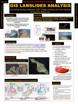
- 1. April, April, 2011 p University of Southern California M.Sc GIS Program – GEOG 587 class Presen ed by Edmundo M. Zeva os am GEOG 587 c a Zevall of existing roadway between USC Wrigley Institute and Two Harbors At Catalina Island CA Island, CA. O Introduction t oduct o Hypothesis ypot es s Presented by: Edm A Landslide is a Mass movements under In g d t I regard to spatial l d lid analysis, GIS i an i p t t p ti l landslide ly i , is important influences of gravity occur as a result of tool t t l to carry out data input, handling, visualization, y t d t i p t, h dli g, i li ti , combination, query, analysis. bi ti , q y, ly i M.Sc. S P diverse disturbing and destabilizing processes. processes The stability of slopes is d t The stab ty of slopes is dete i ed by t bilit determined b d t the geometry of su faces a d slip- the geo et y of surfaces and slip t horizons. ho i o s Research Area Methods et ods • C t li I l d is a rocky i l d off the coast of the U S state of C lif i Catalina Island i k island ff th t f th U.S. t t f California, located about 22 miles (35 km) south-southwest of L Angeles, California. l t d b t il k ) south southwest f Los A th th t l C lif i - A method of collection data has • This is an analysis of landslide in an specific area of the Catalina Island Island. been applied through three step: • Study Area is located in the north west part (section, third) of the island y p ( (section, ) 1.- Landslides i e t y 1 La d lid inventory ds des to • In the East-West existing roadway between the USC Wrigley Institute facility East West and mapping mapping. and the town of Two Harbors Harbors. 2.- 2 Preparation of terrain p parameter maps maps. 3.- 3 Analysis of the relation Research Aims bet between la dslid dist ib tio b t ee landslide distribution d de d t but This research follows a spatially-distributed spatially distributed and terrain parameter maps maps. data with a geo reference to real world geo-reference world. -Landslide inventory have Landslide y conducted from internal data base and fieldwork fieldwork. -All the information concerning the All type, type length and width of landslides bodies is entered in the database G S a ys s o a ds des a d te a pa a ete s GIS Analysis of landslides and terrain parameters Co c us o Conclusion -This research shows that in the area of This the analysis there are two types of landslides: 1. l h fl h i landslide 1 - slow earth flow their l d lid masses are quite small. q it ll 2. 2 - rock falls occur in limestone formations -Since the slides has occurred at the Since upper regions and hence short-term i dh short t h t term remediation will be an immediate di ti ill b i di t solution in the form of relief wells wells.