SlideShare a Scribd company logo
1 of 312
Download to read offline
The Geology of Burma (Myanmar): An Annotated Bibliography of
Burma’s Geology, Geography and Earth Science.
By R. Lee Hadden
Topographic Engineering Center September 2008
US Army Corps of Engineers
7701 Telegraph Road
Alexandria, Virginia 22315
UNCLASSIFIED / UNLIMITED
Bibliography of Burman Earth Science
September 2008 2
REPORT DOCUMENTATION PAGE
Public reporting burden for this collection of information is estimated to average 1 hour per response, including the time for reviewing instructions, searching
existing data sources, gathering and maintaining the data needed, and completing and reviewing this collection of information. Send comments regarding this
burden estimate or any other aspect of this collection of information, including suggestions for reducing this burden to Department of Defense, Washington
Headquarters Services, Directorate for Information Operations and Reports (0704-0188), 1215 Jefferson Davis Highway, Suite 1204, Arlington, VA 22202-4302.
Respondents should be aware that notwithstanding any other provision of law, no person shall be subject to any penalty for failing to comply with a collection of
information if it does not display a currently valid OMB control number. PLEASE DO NOT RETURN YOUR FORM TO THE ABOVE ADDRESS.
1. REPORT
DATE
2. REPORT TYPE: Bibliography
4. TITLE AND SUBTITLE: The Geology of Burma (Myanmar): An Annotated
Bibliography of Burma’s Geology, Geography and Earth Science.
6. AUTHOR(S) HADDEN, Robert Lee
7. PERFORMING ORGANIZATION NAME(S) AND ADDRESS(ES)
US Army Corps of Engineers
Topographic Engineering Center
ATTN: CEERD-TO-I
7701 Telegraph Road
Alexandria, VA 22315-3864
9. SPONSORING / MONITORING AGENCY NAME(S) AND ADDRESS(ES)
Geospatial 7701 Telegraph Road
Library Alexandria, VA 22315-3864
12. DISTRIBUTION / AVAILABILITY STATEMENT
Unclassified/Unlimited
13. SUPPLEMENTARY NOTES:
14. ABSTRACT
A bibliography on Burma prepared by the Topographic Engineering Center
(TEC) to assist with humanitarian efforts offered by the US Government
after the devastating Cyclone Nargis hit Burma on May 2, 2008. As such,
this bibliography covers items of interest to disaster engineers and
emergency planners, including citations on topography, transportation,
water, medical concerns, and security.
15. SUBJECT TERMS: Burma. Climate. Earth Sciences. Forests. Geology. Geography.
Groundwater. Hydrology. Maps. Meteorology. Mining. Myanmar. Soils.
Surface-water. Transportation. Water.
16. SECURITY CLASSIFICATION OF:
Unclassified/Unlimited
17. LIMITATION
OF ABSTRACT
18. NUMBER OF PAGES 312
a. REPORT b. ABSTRACT
Unclassified/Unlimited
c. THIS PAGE
Unlimited
Burma
The Geology of Burma (Myanmar):
An Annotated Bibliography of Burma’s
Geology, Geography and Earth Science
By
R. Lee Hadden
Topographic Engineering Center (TEC)
Engineer Research and Development Center (ERDC)
7701 Telegraph Road
Alexandria, VA 22315
September 2008
Robert.L.Hadden@us.army.mil
Preface
This bibliography was produced quickly by the Topographic Engineering Center
(See: http://tec.army.mil/Burma/index.html) in response to the humanitarian crisis caused
by the Cyclone Nargis which hit Burma in May 2, 2008. The cyclone packed winds of
215 km/hr (135mph) and with very heavy rains. The cyclone made landfall in Burma as a
Category 4 cyclone, with catastrophic results, with estimates of 146,000 fatalities, and
thousands more people missing, injured and homeless.
These two images below are provided from NASA, and show the overwhelming
amount of damage caused by Cyclone Nargis to Burma. Flood water can be difficult to
see in photo-like satellite images, particularly when the water is muddy. This pair of
images from the Moderate Resolution Imaging Spectroradiometer (MODIS) on NASA’s
Terra satellite uses a combination of visible and infrared light to make the floodwaters
obvious to the viewer. Water is blue or nearly black, vegetation is bright green, bare
ground is tan, and the clouds are white or light blue.
On April 15, 2008 (the top image), rivers and lakes are sharply defined against a
backdrop of vegetation and fallow agricultural land. The Irrawaddy River flows south
through the left-hand side of the image, splitting into numerous distributaries known as
the Mouths of the Irrawaddy. The wetlands near the shore are a deep blue green. Cyclone
Nargis came ashore across the Mouths of the Irrawaddy and followed the coastline
northeast.
The entire coastal plain of Burma is flooded in the May 5 image (the bottom
image). The fallow agricultural areas appear to have been especially hard hit. For
example, Yangôn (population over 4 million) is almost completely surrounded by floods.
Several large cities (population 100,000–500,000) are in the affected area. Muddy runoff
colors the Gulf of Martaban turquoise.
The high-resolution image provided above is at MODIS’ maximum spatial
resolution (level of detail) of 250 meters per pixel. The MODIS Rapid Response Team
provides twice-daily images of the region in additional resolutions and formats, including
photo-like natural color.
Bibliography of Burman Earth Science
September 2008 4
Relief efforts were slowed or non-existent as the Burmese military rulers initially
refused aid from outside the country. By May 12-20, 2008, the US Department of
Defense coordinated $1.2 million dollars of relief supplies on 36 USAF C-130 flights.
The relief supplies would provide needed help to some 113,000 storm victims. Much
more aid was needed.
President George Bush also ordered the Essex group, composed of the USS
Essex, the USS Juneau, the USS Harpers Ferry, and elements of the Third Marine
Bibliography of Burman Earth Science
September 2008 5
Expeditionary Force (III MEF), to stand by offshore with relief supplies, disaster
engineering expertise and medical assistance.
The Topographic Engineering Center (TEC) has scanned a number of geological
and hydrological maps of Burma to assist the disaster planners on these ships and
elsewhere. This data is used to select locations for supply dumps, emergency hospital
locations, sanitation and clean water supplies. Other data on transportation and terrain
helped with the airlifting of supplies, evacuating of the injured, and the prevention of
bottlenecks in air, land and water traffic.
The government of Burma refused permission for the US Navy and Marines to
aid the survivors. The Essex group stood off the coast of Burma, waiting for permission
to lend its support of supplies, helicopters and manpower, but it was never given.
Although the humanitarian aid was refused, the TEC webpage has also helped
civilian relief agencies in their efforts. The data is available around the world, and the US
government, the United Nations and a number of non-governmental organizations have
made use of this data in their humanitarian relief efforts.
Copyrighted and sensitive materials have been placed behind the PKI site, and are
available only to US government civilian and military personnel with CAC access.
However, most of the information is from open sources, and thus is available to anyone.
Special thanks are given to all those people outside of the Topographic
Engineering Center who helped in this emergency project. They include the Reference
Staff of the US Geological Survey Library who replied promptly to our requests and
made their services so accessible (http://library.usgs.gov/); the public services staff of the
Defense Technical Information Center (DTIC) who responded so quickly to our requests,
and bent over backwards to make their information available online to the public
(http://www.dtic.mil/dtic/index.html); the Reference Staff of the Geography and Map
Division, The Library of Congress (http://www.loc.gov/rr/geogmap/) and to Mr. Willie
Sayeed of RefWorks for the use of their services in putting together and updating the
bibliography of citations from so many different electronic and manual resources so
quickly (www.RefWorks.com).
Introduction
The Land:
The country is known by several names: the conventional long form: “Union of
Burma”; conventional short form: “Burma”; local long form: “Pyidaungzu Myanma
Naingngandaw” (translated by the US Government as “Union of Myanma” and by the
Burmese as “Union of Myanmar”); local short form: “Myanma Naingngandaw”; former:
“Socialist Republic of the Union of Burma”. Note: since 1989 the military authorities in
Burma have promoted the name Myanmar as a conventional name for their state; this
decision was not approved by any sitting legislature in Burma, and the US Government
did not adopt the name, which is a derivative of the Burmese short-form name Myanma
Naingngandaw.
The capital city is Rangoon (Yangon), with geographic coordinates: 16 48 N, 96
09 E. Strategically, Burma holds a strategic location near major Indian Ocean shipping
lanes.
Bibliography of Burman Earth Science
September 2008 6
The time difference: UTC+6.5 (11.5 hours ahead of Washington, DC during
Standard Time). Note: Nay Pyi Taw is actually the administrative capital. There are
seven administrative division (taing-myar, singular - taing) and 7 states (pyi ne-myar,
singular - pyi ne). The divisions are: Ayeyarwady, Bago, Magway, Mandalay, Sagaing,
Tanintharyi, Yangon. The seven states are: Chin, Kachin, Kayah, Kayin, Mon, Rakhine
and Shan.
Burma lies in Southeastern Asia, bordering the Andaman Sea and the Bay of
Bengal, between Bangladesh and Thailand. It is slightly smaller in land area than Texas,
and has a total area of 678,500 sq km. Of this, land covers 657,740 sq km, and water
covers 20,760 sq km. The national boundaries total: 5,876 km, with border countries
boundaries of: Bangladesh at 193 km; China at 2,185 km; India at 1,463 km; Laos at 235
km and Thailand with a shared boundary of 1,800 km. There is also 1,930 km of
coastline.
The Physical Features of Burma1
Geology, Topology and Terrain
As a country, Burma slopes downward in elevation from the north to the south,
and is naturally divided into “Upper Burma” and “Lower Burma”. The terrain is made up
of central lowlands ringed by steep, rugged highlands. In the north, the Hengduan Shan
mountains form the border with China. Mount Hkakabo Razi, located in the Kachin State,
is at an elevation of 5,881 m (19,295 ft), and is the highest point in Burma. The mountain
ranges in Burma generally run from north to south as well. Three of these mountain
ranges, namely the Rakhine Yoma, the Bago Yoma, and the Shan Plateau, all exist within
Burma, and all of these ranges run from north-to-south from the Himalayas.
These mountain chains also divide Burma's three main river systems, which are
the Irrawaddy (aka Ayeyarwady), the Salween (aka Thanlwin), and the Sittang rivers.
Burma's longest river, the Irrawaddy River, is nearly 2,170 kilometers (1,348 mi) long,
and it flows through the country and into the Gulf of Martaban. Fertile plains exist in the
valleys between the mountain chains. The majority of Burma's population lives in the
Irrawaddy valley, which is situated between the Rakhine Yoma and the Shan Plateau.
As a whole, Burma can be divided into five physiographic regions: the northern
mountains; the western ranges; the eastern plateau; the central basin and lowlands, and
finally the coastal plains.
The northern mountain region consists of a series of ranges that form a geological
complex at Mount Hkakabo. In terms of plate tectonics, this geological complex or
“geologic knot” marks the northeastern limit of the encroaching Indian-Australian Plate.
The Indian-Australian Plate has been colliding with the southern edge of the Eurasian
Plate for roughly the past 50 million years, and has been thrusting up the mountain ranges
1
The data in this introductory section are collected from a number of open literature and common
knowledge publications and resources, such as various almanacs, AGI’s “Glossary of Geology”,
geographical dictionaries and gazetteers; encyclopedias such as the World Survey of Climatology, the
Encyclopedia Britannica, Encarta, Water Encyclopedia, etc.; open source government publications and
websites from the US Department of State, the Library of Congress, the Defense Technical Information
Center, the Food and Agriculture Organization of the UN and others; the CIA Factbook, and several
different reports, articles and books on Burma from federal government geological and geographical
resources.
Bibliography of Burman Earth Science
September 2008 7
of Burma and the regions beyond. This northern mountain physiographic region contains
the sources of several of Asia’s great rivers, including the Irrawaddy, which rises and
flows wholly within Burma, and the Salween, which rises to the north in China. The
upper courses of these rivers all flow through deep gorges within a short distance of each
other, separated by steep, sheer peaks. Jade and other minerals are mined in these
northern mountains.
The western range region traverses the entire western side of Burma, from the
northern mountains to the southern tip of the Rakhine (Arakan) Peninsula, where they run
under the sea and then reappear above the ocean as the Andaman and Nicobar Islands,
territories of India. The mountains’ average elevation is about 1,800 meters (6,000 feet),
although some peaks rise in height to 3,000 meters (10,000 feet) or higher. These
mountains consist of old crystalline rocks surrounded by hard, tightly folded sedimentary
rocks on either side. From north to south, the Patkai Range, the Naga Hills, and the Chin
Hills form the borders between India and Burma. To the south of these are the Rakhine
Mountains (Arakan Mountains), which lie entirely within Burma and separate the coastal
strip from the central basin.
Occupying the eastern half of the country, the Shan Plateau is deeply dissected,
with an average elevation of about 900 meters (3,000 feet). The Shan Plateau to the east
rises abruptly from the central basin, often in a single step of some 600 meters (2,000
feet). Because of the geology of this region, rubies and sapphires have been mined in the
northern Shan Plateau since pre-colonial times. Burma’s rulers depend on sales of these
precious stones such as sapphires, pearls and jade to fund their regime. Rubies are the
biggest earner; 90% of the world's rubies come from the country, whose red stones are
prized for their purity and hue. Thailand buys the majority of the country's gems. Burma's
“Valley of Rubies”, in the mountainous Mogok area, about 200 km (125 miles) north of
Mandalay, and is noted for its rare pigeon's blood rubies and blue sapphires
The Shan Plateau was formed during the Mesozoic Era, some 248 to 65 million
years ago, and thus is a much older geologic feature than the western mountains. But the
Shan Plateau also shows more-recent and intensive folding than the western mountains,
with north-south longitudinal ranges rising steeply to elevations of 1,800 to 2,600 meters
(6,000 to 8,600 feet) above the plateau surface. Northward, the plateau merges into the
northern mountains, and southward it continues into the Dawna Range and to the
peninsular Tenasserim Mountains (aka Tanintharyi Mountains), each a series of parallel
ranges with narrow valleys.
The central basin and lowlands, lying between the Rakhine Mountains and the
Shan Plateau, are structurally connected with the folding of the western ranges. The basin
was deeply excavated by the predecessors of the Irrawaddy, Chindwin, and Sittang rivers;
the valleys are now occupied by these rivers, which cover the ancient soft sandstones,
shales, and clays with their alluvial deposits.
The Basin of the Irrawaddy, with its tributaries the Chindwin, Shweli, and
Myitnge rivers, occupies most of Burma. In the delta regions formed by the Irrawaddy
and Sittang rivers, the landscape is absolutely flat, and the monotony is relieved only by a
few blocks of erosion-resistant rocks that are never more than 18 meters (60 feet) high.
The basin is divided into two unequal parts, the larger Irrawaddy valley and the smaller
Sittang valley. Between these two valleys are the Bago Mountains. In the centre of the
basin and also structurally connected with the Bago Mountains and their northern
Bibliography of Burman Earth Science
September 2008 8
extension, is a line of extinct volcanoes with small crater lakes and eroded cones. The
largest of these eroded volcanic cones is Popa Hill, at 1,518 meters (4,981 feet).
The coastal areas consist of the narrow Rakhine and Tenasserim plains, which are
backed by the higher ranges of the Rakhine and Tenasserim mountains. These coastal
regions are fringed with numerous islands of varying sizes.
As to economic geology, Burma is rich in certain minerals, including metal ores,
petroleum, and natural gas. Deposits of silver, lead, zinc, and gold are concentrated in the
northern Shan Plateau; tin and tungsten in the Tenasserim region, and barite around the
town of Maymyo in the central basin. Copper mining at the town of Monywa began in
the early 1980s and has been growing, despite intermittent setbacks caused by shortages
of fuel and supplies as well as by economic sanctions imposed by foreign governments.
Large-scale exploitation of Burma’s mineral deposits began in the mid-1970s.
Although production generally has been increasing since the late 20th century, mining
accounts for only a tiny fraction of the country’s GDP and a comparable portion of the
workforce.
The country also has significant deposits of precious and semi-precious stones.
Burmese rubies are internationally known for their deep color and quality. The country
also produces smaller quantities of spinels2
, diamonds, and other gemstones.
Weather and Climate
Although Burma is located in the monsoon region of Asia, its climate is greatly
modified by its geographic position and its topographical relief. The cold air masses of
Central Asia bring snow to the northern mountains for two months of the year, but this
mountain wall prevents the cold air masses from moving farther south, so that Burma lies
primarily under the influence of the monsoon winds. The north-south alignment of ranges
and valleys also creates a pattern of alternate zones of heavy and scanty precipitation
during both the northeast and southwest monsoons. Most of the precipitation, however,
comes from the southwest monsoon. The west coast is subject to occasional tropical
cyclones.
Most of Burma lies between the Tropic of Cancer and the Equator. The Tropic of
Cancer divides the country into two regions: the tropical south that covers two-thirds of
the country, and the sub-tropical and temperate north, which is the remaining one-third of
Burma. This causes two distinct seasons: the dry season from mid-October to Mid-May,
and the wet season. There is a cooler spell during the wet season from December to
February.
The coastal regions and the western and southeastern ranges receive more than
200 inches (5,000 mm) of precipitation annually, while the delta regions receive about
100 inches (2,500 mm). The central region is not only positioned away from the sea but
also on the drier, lee side- in the rain shadow- of the Rakhine Mountains. Precipitation
gradually decreases northward until in the region’s dry zone it amounts to only 20 to 40
2
Probably named from the Latin word "spina", (meaning "thorn"), for its pointed (octahedral) crystals.
Spinel is a hard mineral with octahedral crystals found in igneous and carbonate rocks. Spinel occurs
typically as a contact metamorphism of impure dolomitic limestone, and less commonly as an accessory
mineral of basic igneous rocks. Spinal also occurs in alluvial deposits. It consists essentially of alumina and
magnesia (MgAl2O4), but commonly contains ferrous iron and sometimes also chromium. It is found in a
variety of colors including blue, green, brown, black, and the valuable red variety which resembles a ruby,
and is frequently used as a gemstone.
Bibliography of Burman Earth Science
September 2008 9
inches (500 to 1,000 mm) per year. The Shan Plateau, because of its elevation, usually
receives between 75 and 80 inches (1,900 and 2,000 mm) annually.
Monsoons
As said above, Burma also lies in the monsoon region of Asia, with its coastal
regions receiving over 5,000 mm (200 in) of rain annually. Annual rainfall in the
southern delta region is approximately 2,500 mm (100 in), while average annual rainfall
in the Dry Zone, which is located in central Burma, is less than 1,000 mm (40 in).
Burma has a monsoon climate with three main seasons: the hot period, the rainy
season and the cooler period.
The hottest period is between February and May, with little or no rain. At the end
of this season, generally from March to April, the average monthly temperature reaches
the upper 30°s C (lower 100°s F) in many parts of Burma. The average daily
temperatures in Yangon (Rangoon) range from 24° to 36°C (75 to 97°F) in April, during
the hot season.
The climate of Burma and other countries in South and Southeast Asia follows a
typical monsoon pattern. During the half of the year that the sun’s rays strike directly
above the equator, the land mass of Asia is heated more than is the Indian Ocean. This
draws moist hot air from over the ocean onto the land, bringing the rains of the southwest
monsoon season. The Monsoon or Rainy season, also called “the hot and wet season”,
exists usually from May to October.
In Burma during this hot and wet season, rain usually falls nearly every day and
sometimes all day long, and almost all of Burma’s annual rainfall occurs during this time.
Rainfall during the monsoon season totals more than 500 cm (200 in) in upper Burma and
over 250 cm (100 in) in lower Burma and Yangon (Rangoon). Central Burma, called the
dry zone, and Mandalay, the chief city in this area, each receive about 76 cm (30 in). By
July rains have brought the average temperature down to 29°C (84°F) in Mandalay and
27°C (81°F) in Yangon.
Average annual rainfall during this season varies from about 5,000 mm (about
200 in) on the Tenasserim Coast to about 760 mm (about 30 in) at Mandalay. The
country receives practically all its rainfall between mid-May and October, the period of
the Southwest Monsoon. Annual precipitation in most of Upper Burma averages about
890 mm (about 35 in) and in Lower Burma about 5080 mm (about 200 in). The climate is
tropical monsoon, with cloudy, rainy, hot and humid summers during the height of the
southwest monsoon season, from June to September.
When the tilt of the earth brings the direct sun rays south of the equator, the
heating of the Indian Ocean draws the cooler dry air of the northeast monsoon from the
highlands of Asia across the countries of South and Southeast Asia. The dry, cooler
weather is from October/November to February. The hot, dry inter-monsoonal season is
from mid-February to mid-May. The country is less cloudy, with scant rainfall and mild
temperatures and lower humidity during the winter. This is the time of the cool, relatively
dry northeast monsoon.
In this cooler season, which runs from late October to mid-February, the
temperature for January averages 25°C (77°F) in Yangon in Lower Burma and 20°C
(68°F) in Mandalay in Upper Burma. The average daily temperatures in Yangon
(Rangoon) range from 18° to 32°C (64-90°F) in January, during this cooler season.
Bibliography of Burman Earth Science
September 2008 10
In Burma, the mean annual temperature is 27°C (81°F). Although Burma is a
tropical country, temperatures are not uniformly high throughout the year and throughout
the country. The daily temperature range in Burma is greater than that temperature range
in nearly all other parts of Southeast Asia. But no region in Burma has a continental type
of climate (i.e., one characterized by large seasonal differences in average temperature).
However, the average daily temperatures in Burma show little variation across the
country, ranging from 26 °C to 28 °C (79 °F to 82 °F) between Sittwe in the Rakhine
region, Yangon near the coast, and Mandalay in the northern part of the central basin. At
Lashio, on the Shan Plateau, the average daily temperature is somewhat cooler, around 22
°C (71 °F).
Elevation and distance from the sea affect temperature as well, and temperatures
are generally lower in Burma’s mountainous regions. The northern regions of Burma are
the coolest in the country, with average temperatures of 21°C (70°F). Thus the climate in
upper Burma, especially at altitudes ranging from about 300 to 1,220 meters (1,000–
4,000 ft) of elevation, remains the most temperate throughout the year.
Mandalay, in the centre of the dry zone, has some of the greatest daily
temperature ranges, which span about 12°C (22°F) annually.
Lower Burma, especially in the river delta and along the coastal regions, is the
most humid part of the country. The coastal and delta regions have a mean annual
temperature of 32°C (90°F).
Surface and Ground Water Resources
The water resources in Burma from 1999 include 1,045.6 cubic kilometers of total
renewable water resources. Freshwater withdrawal for domestic, industrial and
agricultural use, totals about 33.23 cu km/yr (1%/1%/98%); per capita water withdrawal
in 2000 is about 658 cu m/yr. Environmentally, Burma suffers from deforestation and the
industrial pollution of air, soil, and water. Also the inadequate sanitation and water
treatment contribute to disease.
Like the mountains, Burma’s main rivers run mainly from north to south. About
three-fifths of the country’s surface is drained by the Irrawaddy River and its tributaries.
The Rakhine coastal plains are drained by short, rapid streams, which, after forming
broad river deltas, flow into the Bay of Bengal. The Tenasserim plains also are drained
by short and rapid rivers, which enter the Gulf of Martaban.
The Bassein River, also known as the Pathein River, drains the southern Rakhine
Mountains. The Bassein River is about 257 kilometers (160 miles) long, and is chiefly a
navigable outlet of the Irrawaddy River in the western part of the delta.
Chindwin River: The great tributary of the Irrawaddy, the Chindwin, is about
1,158 km (750 miles) long, and drains the western region. The Chindwin River
(Burmese: Chindwin Myit) is the largest tributary of the Irrawaddy River. It flows
entirely within Burma and is known as “Ning-thi” to the Manipuris. The Chindwin rises
in the Kumon Range in northern Burma, and flows northwest through the Hukawang
Valley, then south along the Indian border and then southeast to the Irrawaddy River at
Myingyan.
The Chindwin is navigable for some 500 miles (800 km) from its confluence with
the Irrawaddy below Mandalay to the confluence with the Uyu River, its chief tributary.
Bibliography of Burman Earth Science
September 2008 11
The Chindwin is served by regular river-going vessels up to the town of Homalin. Much
of Chindwin's course lies in the within mountain ranges and forests.
Due to the difficulty of access, much of the un-navigable river area remains
unspoiled. The government of Burma recently created a very large (2,500 square mile)
sanctuary for the endangered tiger within the Hukawng Valley. Teak forests within the
drainage area have been a valuable resource since ancient times. The Hukawng Valley is
known for its abundance of Burmese amber. Along the river, there are also deposits of
jade, but the best jade is found in the region around the headwaters of the Uyu river.
The Irrawaddy River: The country’s trade in rice is dependent on water transport,
and the Irrawaddy River is the backbone of Burma’s transportation system. The
Irrawaddy River starts in the North of Kachin State, at the confluence of the Mali Hka
and N'Mai Hka rivers north of Myitkyina. The western Mali Hka branch arises from the
end of the southern Himalayas, north of Putao, and, like the main river, is called “Nam
Kiu” in the Shan language. The river then flows south through Burma to the Bay of
Bengal through several mouths near Rangoon. Flowing entirely through Burma, the
Irrawaddy is about 2,092 km long (1,300 miles), and it is navigable year round for nearly
1,000 miles (1,600 km) up to the junction with the Bhamo, the main tributary of the
Chindwin River.
The Irrawaddy River bisects the country from north to south and empties into the
Indian Ocean through a nine-armed Irrawaddy Delta. In colonial times, before railways
and automobiles, the river was known as the “Road to Mandalay”. Although navigable by
large vessels to Myitkyina for a distance over 1,600 km from the ocean, the river is also
full of sandbanks and islands, making such navigation difficult. For many years, the only
bridge built to cross the Irrawaddy River was the Inwa Bridge.
At the apex of its delta, the Irrawaddy breaks up into a vast network of streams
and empties into the Andaman Sea through multiple mouths. The many streams of the
Irrawaddy delta are navigable, and there is a regional system of inter-connecting canals.
The Kaladan River is a river located in the west of the country around the Sittwe
area. The Burmese government was working on a $500 million project in cooperation
with India to attempt to facilitate river trade between the two nations. The Kaladan River
trade will open up not only Mizoram but India's entire North East as a hinterland for the
Burma port of Sittwe. Development of the river is also being negotiated with the Shwe
Gas Project for economic enhancement.
The Kok River originates in Shan State, Burma. It flows down and across the
Burma-Thailand border to Mae Ai district, Chiang Mai Province. Most of its length is in
Chiang Rai Province passing the districts Mueang Chiang Rai, Mae Chan, Chiang Saen
and Wiang Chai. It becomes a tributary to the Mekong River in Chiang Saen district.
The Mali River (Mali Hka) is a river that originates in northern Burma. It flows
approximately 320 km, when it meets with the Nmai River and their confluence forms
the Irrawaddy River.
The Mekong is one of the world’s major rivers. It is the 11th-longest river in the
world, and 7th longest in Asia, discharging 475 km3
/114 cu mi of water annually. Its
estimated length is 4,350 km (2,703 mi), and it drains an area of 795,000 km2
(307,000 square miles). From high in the Tibetan Plateau, the Mekong runs through
China's Yunnan province, then through Burma, Thailand, Laos, Cambodia and Vietnam.
All the other countries except China and Burma belong to the Mekong River
Bibliography of Burman Earth Science
September 2008 12
Commission. The extreme seasonal variations in flow and the presence of rapids and
waterfalls have made navigation extremely difficult along the river.
The Moei River is a tributary of the Salween River. It originates in Phop Phra
district, Tak Province. Unlike most rivers in Thailand, the Moei flows north. The river
forms the natural border line between Thailand and Burma. The districts along the Moei
River bank of Thailand, from South to North are Mae Sot, Mae Ramat, Tha Song Yang
and finally it enters the Salween River in Sop Moei district of Mae Hong Son Province.
The river is about 327 km long.
The Rangoon River, also known as the Yangon River, is about 40 km long (25
miles), and flows from southern Burma as an outlet of the Irrawaddy River into the
Irrawaddy delta. The Rangoon River drains the Bago Mountains; both the Rangoon and
the Bassein Rivers enter the Irrawaddy at the delta.
The Ruak River is a river along the Thai-Burma border. It originates within the
hills of the Shan State of Burma, and becomes the boundary river between Thailand and
Burma at the confluence with the Mae Sai River at the northernmost point of Thailand. It
then meanders to the east until it empties into the Mekong River at Ban Sop Ruak,
Tambon Wiang, Chiang Saen district, Chiang Rai Province. The boundary section of the
river is 26.75 km long.
The Shan Plateau is drained by the Salween River, which enters Burma from
southern China and empties into the Gulf of Martaban southeast of the Sittang. The
Salween rises in the Plateau of Tibet, and then flows east through Sichuan, then south
through the western Yunnan province of southwestern China. The Salween is about 2,415
km long (1500 miles). Many of its tributaries are more than 480 km (300 miles) long and
join the Salween in cascades. The river continues south through Burma, and its lower
course becomes part of the boundary between Thailand and Burma. The river empties
into the Gulf of Martaban at Moulmein. The Salween River, because of its rapids, is
navigable for less than 160 km (100 miles) from the sea.
The Salween River is deeply entrenched and crosses the Shan Plateau in a series
of deep gorges. It is home to over 7,000 species of plants and 80 rare or endangered
animals and fish. UNESCO said this region “may be the most biologically diverse
temperate ecosystem in the world” and designated it a World Heritage Site in 2003.
The Salween is the longest undammed river in mainland Southeast Asia.
Proposals to build several dams along the river, mainly in Burma, are controversial.
Thailand is studying the feasibility of jointly constructing the Hatgyi Dam on the
Salween River near the border with Burma; citing environmental, cultural, and social
concerns, China is reconsidering construction of 13 dams on the Salween River but
energy-starved Burma with backing from Thailand remains intent on building five hydro-
electric dams downstream, despite identical regional and international protests.
The Sittang River flows into the Gulf of Martaban of the Andaman Sea. The
Sittang flows in east central Burma, and then flows south to the head of the Gulf of
Martaban. The river is about 418 km long (260 miles) and, for a comparatively short
river, it has a large valley and delta.
Although the Sittang River flows through fairly flat country, the Sittang has a
notorious tidal bore at its mouth which has precluded any but very small craft navigating
the river. Strong currents make the river even less valuable as a means of transport in
eastern Burma. The Sittang, in spite of its silt, is usable by smaller boats, but its basin
Bibliography of Burman Earth Science
September 2008 13
does not have the same richness for agriculture as the Irrawaddy because there is no soil
flowing from the Himalayas.
The Zawgyi River is a river of eastern Burma. It flows through the foothills of the
Shan Mountain range in Shan State.
Burma has two major lakes. The Indawgyi Lake, in the northern hills, runs some
24 km (15 miles) from north to south and 13 km (8 miles) from east to west. The
Indawgyi is one of the largest natural inland lakes of Southeast Asia.
Somewhat smaller is Inle Lake, stretching about 22 km (14 miles) from north to
south and 11 km (7 miles) from east to west, is located on the Shan Plateau. The Inle
Lake is fed by dozens of streams.
Bibliography of Burman Earth Science
September 2008 14
Geography
The life expectancy in Burma is: Male 58 years; Female 63. Hospitals 1:1,586.
The literacy rate is 78%.
The major ethnic groups in Burma are: Burman 68%, Shan 9%, Karen 7%,
Rakhine 4%, Chinese 3%, Indian 2%, Mon 2%, other 5%. Complicating national unity,
over half of Burma's population consists of diverse ethnic groups who have substantial
numbers of kin living in neighboring countries. Thailand must deal with Karen and other
ethnic refugees, asylum seekers, and rebels, as well as illegal cross-border activities from
Burma. India also seeks cooperation from Burma to keep Indian Nagaland separatists,
such as the United Liberation Front of Assam, from hiding in the remote Burmese
Uplands.
Image taken from: “Burma: A Country Study.” 1984.
Foreign Area Studies, the American University. 3rd
edition. US GPO.
Bibliography of Burman Earth Science
September 2008 15
The Burmans, who form the largest ethnic group, account for more than half of
the population. They are concentrated in the Irrawaddy River valley and in the coastal
strips, with an original homeland in the central dry zone.
The Shans (shahns) are about 9% of the population. “Once the masters of the
Burmans when they ruled after the collapse of the Pagan-based monarchy, the Shans have
no historical inferiority complex. In the centuries after the Pagan period, the Shans
developed their own monarchies where Shan mandalas of power oscillated constantly as
more powerful Burmese and Thai kings contested each other. Deference to outside
royalty was a small price to pay for considerable Shan independence internally. The
Shans in 1983 were basically rice farmers, skillful traders, and a valley people. In matters
of governance, historically they have allowed an aristocratic elite to rule them.”
The Shan of the Shan Plateau have little ethno-linguistic affinity with the
Burmans, and, although historically led by hereditary rulers, their society was less
elaborately structured than that of the plains peoples. The Shan represent a small but
significant portion of the country’s population. The ethnographic complexity of the
highlands occasionally leads to mis-groupings of some of the smaller communities with
their more prominent neighbors. For example, the Wa and the Palaung of the Shan
Plateau are often grouped with the larger, but ethnically and linguistically distinct, Shan
community.
The Karen ethnic group is about 7% of the Brumese population. “It has been
fashionable to call the traditional religion of people like the Karens a form of animism, or
‘spirit worship.’ The word never does justice to such beliefs, which may be as complex
and lofty as those of the major religions of the world. Traditional Karens, like so many
other peoples, believe that both matter and spirit are realities, each possibly inhabiting the
same entity at a given time or perhaps later separated but still linked. There are Karen
gods, rituals, and oral religious traditions so impressive that early missionaries toyed with
the belief that the Karens were a lost tribe of Israel. No matter where Karens live, they
characteristically have a strong sense of ethnic pride.”
The Karen are the only hill people who have settled in significant numbers in the
plains. Constituting about one-tenth of the population, they are the second largest ethnic
group in Burma. They are found in the deltas among the Burmans, in the Bago
Mountains, and along both sides of the lower Salween River. The Kayah, who live on the
southern edge of the Shan Plateau, were once known as the Red Karen, or Karenni,
apparently for their red robes. Although ethnically and linguistically Karen, they tend to
maintain their own identity and hereditary leadership.
The Chin (pronounced “JIN”): In the western hills and the Chindwin River valley
are various groups called by the comprehensive name of Chin. “Turbulent, competitive,
legalistic, and yet very social, the Chins did not take to Christianity as well as did the
Karens. Like the Karens, those who are Christians (possibly one-quarter of the
population) have hoped to use their new faith to link with outside powers to protect their
people from being engulfed by Burmans. The Chin religion, in which the door to paradise
is opened by hinting done in the proper way to honor and contend with the spirits of what
is killed, can be seen in contrast to the Buddhism of their neighbors, where taking life is
normatively scorned. Animal sacrifice, so common among hill peoples, is likewise
condemned by valley Buddhists.” The Naga on the Burma side of the frontier with India
sometimes are mistakenly placed with the Chin
Bibliography of Burman Earth Science
September 2008 16
Numerous small ethnic groups, most of which inhabit the upland regions, together
account for roughly one-fifth of Burma’s population. The upper Irrawaddy valley and the
northern hills are occupied by groups under the comprehensive name of Kachin. These
peoples long have had an association with the Burmans. The Muhso (a Lahu people) in
northeastern Burma are sometimes grouped with the Kachin.
Chinese, Indians, and other minorities in Burma: “Since only people who can
prove long familial links to Burma are accorded full citizenship, ethnic populations such
as Muslims, Indians, and Chinese, continued to be denied full citizenship and to be
excluded from government positions. People without full citizenship are not free to travel
domestically and are barred from certain advanced university programs in medicine and
technological fields. Anti-Chinese and anti-Muslim sentiment remained pervasive.”
Religions
The major religions of the country are: Buddhist 89%, Christian 4% (Baptist 3%,
Roman Catholic 1%), Muslim 4%, animist 1%, other 2%.
Theravada Buddhism: “In strict orthodox Theravada Buddhism, Gotama
(Siddhārtha Gautama) was merely a human being; he does not exist anywhere to hear
people’s prayers. His words are left in the sacred books and can be learned from his
‘sons,’the living Theravada monks, who exist today as the Buddha once instructed the
first monks to live. All Burmans share in this heritage and follow some semblance of the
strict orthodox teachings. The Buddhism of the Pali scriptures, however, often differs
from actual religious beliefs and practices in modern Burma.” (all quotations are from the
Library of Congress Country Studies/Area Handbook--Burma [Myanmar])
Hinduism: Burma has a substantial number of Hindu adherents in Rakhine.
However, many Burmans remember the use of Indian soldiers to colonize and conquer
Burma, and thus are looked upon unfavorably by the majority. Also, many of the
Buddhist beliefs claim superiority over Hinduism, and the traditional Hindu gods are
relegated to godlings who must be reborn as Buddhist humans.
Islam: “The historically porous border between Burma and Bangladesh and India
has been the source of perpetual movement of Muslims back and forth in response to
their various political fortunes. Although the potential was always there for Buddhist-
Muslim confrontation, in general the two groups have managed to live peaceably side by
side but without much interaction.” Mosques are found in Arakan, Rangoon, and in all
areas where the Muslim community is strong, some of these groups having established
themselves in Burma centuries ago. Mosques are primarily found within the Rakhine
State. Like the Hindu and Chinese populations, Muslims have to keep a low profile in
terms of asserting their ethnic identity in order to avoid the racial antagonism that has
often flared up in the past.” (Human Rights Report...)
Christian: Many Chins, Kachins, Karens and others are Christian. “Minorities in
Burma face a Buddhist majority, and Christianity remains an option for asserting one’s
distinctness, not only for the Karens or Chins, for example, but also for those who have
had a genuine Christian conversion and for others who retain a fierce loyalty to all things
British. On a visit to Mandalay, a visitor attempting, however ineptly, to speak Burmese
should not be surprised to have an impeccably dressed older man watch for a while with a
smile and then speak in exquisite English with a perfect Oxford accent. The same elderly
Bibliography of Burman Earth Science
September 2008 17
gentleman will finish his days as an ardent Christian. No revolution will convert him into
either a Buddhist or a socialist.”
Languages
The majority language is Burmese, though minority ethnic groups have their own
languages.
Many indigenous languages—as distinct from mere dialects—are spoken in
Burma. The official language of the country is Burmese, spoken by the people of the
plains and, as a second language, by most people of the hills. During the colonial period,
English became the official language, but Burmese continued as the primary language in
all other settings. Both English and Burmese were compulsory subjects in schools and
colleges. Burmese, Chinese, and Hindi were the languages of commerce. After
independence English ceased to be the official language, and after the military coup of
1962 it lost its importance in schools and colleges; an elementary knowledge of English,
however, is still required, and its instruction is again being encouraged.
The local languages of Burma belong to three language families. Burmese and
most of the other languages belong to the Tibeto-Burman subfamily of Sino-Tibetan
languages. The Shan language belongs to the Tai family. Languages spoken by the Mon
of southern Burma and by the Wa and Palaung of the Shan Plateau are members of the
Mon-Khmer subfamily of Austro-Asiatic languages.
Speakers of Burmese and Mon historically have lived in the plains, while
speakers of a unique dialect of Burmese (that perhaps retains some archaic features of
pronunciation) have occupied the Rakhine and Tenasserim coastal plains. The hills were
inhabited by those speaking Shan, Kachin, Chin, and numerous other languages. In the
plains the ancient division between northern and southern Burma (Upper Burma and
Lower Burma, respectively) was based not only on geographic differences but also on a
linguistic one. The Mon (now a small minority) lived in southern Burma, while the
majority Burman population lived in the northern dry zone.
Until colonial times only Burmese, Mon, Shan, and the languages of the ancient
Pyu kingdom of northern Burma were written. Writing systems for the languages of the
Karen, Kachin, and Chin peoples were developed later.
Bibliography of Burman Earth Science
September 2008 18
Land Use
The area of arable land in Burma during 2005 was 14.92% of the country, with
permanent crops: 1.31% and other uses: 83.77%. In 2003, there were 18,700 sq km of
irrigated land. The major agricultural products of Burma are rice, pulses, beans, sesame,
groundnuts, sugarcane; hardwood; fish and fish products.
According to official estimates, about half of Burma remains covered with forests
or jungles of various types (depending on elevation and the amount of precipitation).
Even after centuries of rice cultivation involving the clearing of forested areas, large
tracts of forest remain, but actual coverage may be less than estimated, however.
Subtropical and temperate forests of oak and pine are found at elevations above
3,000 feet (900 meters). In the northern mountains, above 6,000 feet (1,800 meters), are
forests of rhododendrons. Elephants are numerous in Burma, and many are trained for
work, especially in the timber industries. Tigers, leopards, and wildcats are still common
in the wild. Some bears are found in the hilly regions, and gibbons and monkeys of
various kinds inhabit the thicker parts of the forests.
Tropical evergreen rainforests of hardwood trees occur in areas receiving more
than 2,000 mm (80 inches) of rain annually. In regions where the rainfall is between
1,000 and 2,000 mm (40 and 80 inches) are found broad-leaved tropical-deciduous
monsoon forests, the trees of which shed their leaves during the hot season. They produce
valuable woods, notably teak. The jungles of Burma are home to a profusion of birdlife,
including grouse, pheasants, parrots, peafowl and other wild fowl. The Asian two-horned
rhinoceros (Dicerorhinus sumatrensis), the wild water buffalo, the gaur (a species of wild
cattle), and various kinds of deer were once plentiful but they are now reduced in number
and are protected.
Where rainfall is less than 40 inches, the forests gradually open into scrubland.
There are no true grasslands in Burma, but bamboo, bracken (ferns), and coarse grass
grow in areas where the forest has been cleared and then abandoned.
Snakes include pythons, cobras, and vipers, and crocodiles are found in the deltas.
Turtles live in coastal regions, and edible fish abound in every stream.
The country of Burma can be divided into three distinct agricultural regions: the
Irrawaddy river delta, where cultivation of rice in flooded paddies predominates; the
largely irrigated dry zone, an area primarily of rice production but where a wide variety
of other crops also are raised; and the hill and plateau regions, where forestry and
cultivation of rice and other crops through shifting agriculture are most important.
Delta
The delta’s traditional agriculture consisted primarily of rice in normal years, with
the substitution of millet in drier years or when there was insufficient moisture for rice.
Both millet and rice yielded good returns on the alluvial soils.
Although the dry zone was Burma’s most important agricultural region in the
past, the rice production of the Irrawaddy River delta now provides much of the country’s
export earnings and the staple diet of the country’s people. In the Irrawaddy and Sittang
river deltas are also found tidal forests of mangrove trees that grow as high as 30 meters
(100 feet) and these trees supply firewood and bark for tanning.
Bibliography of Burman Earth Science
September 2008 19
The lowland regions are covered with alluvial soils- mainly silt and clay. Low in
nutrients and organic matter, the planted soils are improved by fertilizers. Burma’s richest
soils are found in a narrow alluvial strip along the Bay of Bengal, where mountain
streams irrigate the land in the wide Irrawaddy and Sittang river valleys. These deep soil
deposits form a vast, fertile belt especially suitable for rice cultivation because of the
abundant moisture.
Dry Zone
The Dry Zone covers approximately 8,718,898 hectares or about 13% of the
country's total land area, and is situated in the lower Sagaing, Mandalay and Magway
Divisions. Based on mean annual precipitation rates the Dry Zone covers 13
administrative districts and 57 townships. The topography is generally undulating. Most
of the local streams are dry for much of the year with water flow is usually limited to the
rainy periods.
Crops grown in the dry zone, in addition to rice and millet, include sugarcane,
fruits (such as plantains), legumes, peanuts or groundnuts, maize, onions, sesame, rubber,
and allspice. To cultivate much of this land successfully, however, irrigation is required.
The earliest known irrigation works were constructed in the 1st century and
greatly improved during the 11th century. Although the irrigation system maintenance
lapsed somewhat after the fall of the monarchy in the late 19th century, many of the
ditches and streams are still in active service. As in the delta, the arrival of the British in
the dry zone led to increased commercial and public-works activities. British authorities
repaired and extended parts of these ancient systems during the early 20th century. Most
of Burma’s irrigated land is in the dry zone, and almost all of it is planted in rice. The
portions of the dry zone that are not irrigated are utilized for the production of crops that
are less sensitive to the seasonality or irregularity of rainfall than rice. In addition to the
crops mentioned above, cotton and millet are cultivated, although neither is of
considerable significance. Cattle also are raised there.
The Dry Zone townships are characterized by clay, sandy loam and sandy soils
that include gravel. The soils clearly vary with topography. According to soil survey data,
all soil series in the Dry Zone have low fertility and have declining organic matter levels.
Potassium levels are also low for agriculture. Nitrogen is required for all non-legume
crops on all soil types. This also suggests the consistent low organic matter level in the
soil.
The soil moisture holding capacity of the soils of the Dry Zone are low and with
the high level of evapotranspiration, impacts agriculture. This lack of moisture in the
ground constitutes a major constraint to crop growth during periods of inadequate
rainfall, such as in June and July. Farm management practices that conserve soil moisture
or increase the water holding capacity of the soils are being practiced to help take
advantage of the full growing season. Hard pan formation is common to all the upland
areas.
In the dry belt of the central region are found red-brown soils rich in calcium and
magnesium. In the same region, however, when the soil has a low clay content, and it
becomes saline under high evaporation that is recognizable by its yellow or brown color.
Soil erosion is a serious problem and in some places in the Dry Zone the soil has
been almost completely removed by water and wind erosion. Soil erosion is particularly
Bibliography of Burman Earth Science
September 2008 20
severe in the upland areas of Kyaukpadaung and Chaung U, largely as a result of the high
intensity of rainfall and rapid surface runoff. Moreover, since most of the soil in these
areas is moderately textured with a slope ranging from 5-15%, the erodibility of the soil
is also high. In Chaung U, the most severe erosion occurs in the upland areas. In contrast,
the incidence of soil erosion in the foot plain is lower. Sheet and rill erosion and vertical
dissection are widespread, resulting in an uneven topography.
In Magway, because of the sandy topsoil there is also a high level of erosion. The
susceptibility of the soil to erosion is compounded by the high level of rainfall occurring
over short periods. Wind erosion is a particularly severe problem while sheet and gully
erosion are largely confined to wasteland areas. Soil erosion and land degradation are the
two components responsible for declining production potential.
Hill and Plateau Country
The third agricultural zone, the hill and plateau country, occupies perhaps two-
thirds of the area of Burma. This land has less economic significance than the other two
zones; it is the home of many of the country’s non-Burman ethnic groups, most of whom
are engaged in shifting cultivation. More-sedentary modes of agriculture also exist,
however, and have been imposed with the advance of agricultural technology, increased
population, and central planning.
The highland regions of Burma are covered with highly leached, iron-rich, dark
red and reddish brown soils. When protected by forest cover, these soils absorb the
region’s heavy rain, but they erode quickly once the forest cover has been cleared.
Outside the forest areas of these highlands, the principal crops raised are rice, yams, and
millet, and large numbers of pigs and poultry are kept. Bullocks and buffalo are used as
draft animals, and goats, pigs, and poultry are raised for food in all parts of the country.
Bibliography of Burman Earth Science
September 2008 21
Myanmar Dominant Soils. Geographical distribution of 10 dominant
soil types in Myanmar. Map created by FAO/NRL from Harmonized
World Soil Database (HWSD) – FAO
Bibliography of Burman Earth Science
September 2008 22
Economy
Burma is one of the poorest nations in southeastern Asia, suffering from decades
of stagnation, mismanagement and isolation. Burma's GDP grows at an average rate of
2.9% annually – the lowest rate of economic growth in the Greater Mekong Sub-region.
Agriculture, forestry, and fishing together constitute the largest contributor to
Burma’s economy. About half of all agricultural land in Burma is devoted to rice, and to
increase production the government has promoted multiple cropping (sequential
cultivation of two or more crops on a single piece of land in a single year), a system that
is easily supported by the country’s climate. As a whole, the sector accounts for nearly
one-half of the country’s gross domestic product and employs about two-thirds of the
labor force.
The second most important element in the diet, after rice, is fish, either fresh fish
or in the form of ngapi, a sort of nutritional paste that is prepared in a variety of ways and
eaten as a condiment. Marine fisheries are not well developed, although the industry’s
reported commercial catch is much greater than that reported from inland waters. Much
private, noncommercial fishing is provided, however, in virtually every type of
permanent, seasonal, or artificial body of inland water of any size. Non-indigenous fish,
including the European carp and the tilapia, originally brought from Thailand, have
become the focus of a growing aquaculture industry.
Under British administration and until the early 1960s, Burma was the wealthiest
country in Southeast Asia. It was once the world's largest exporter of rice. After Burma
was officially annexed to British India in 1886, however, colonial policy called for a
more commercially oriented and more extensive cultivation of rice. Since the indigenous
labor force was thought to be insufficient to support the colonial export economy, the
immigration of Indian and Chinese laborers into Burma was officially encouraged during
the early decades of the 20th century. Despite the departure of much of the immigrant
labor force and the relatively low growth in rice production after World War II, rice
remained both the basic food and, until the 1990s (when it was overtaken by dry beans),
the principal agricultural export of Burma.
Also during the British administration, Burma supplied oil through the Burmah
Oil Company. Burma also had a wealth of natural and labor resources. It produced 75%
of the world's teak and had a highly literate population. The country was believed to be
on the fast track to development.
After a parliamentary government was formed in 1948, Prime Minister U Nu
attempted to make Burma a welfare state. His administration adopted the Two-Year
Economic Development Plan, which was a failure. The 1962 coup d’état was followed by
an economic scheme called the “Burmese Way to Socialism”, a plan to nationalize all
industries, with the exception of agriculture. In 1989, the Burmese government began
decentralizing economic control. It has since liberalized certain sectors of the economy,
although lucrative industries of gems, oil and forestry remain heavily regulated. These
industries have recently been exploited by foreign corporations and governments which
have partnered with the local government to gain access to Burma's natural resources.
The major occupations in Burma are in agricultural processing; wood and wood
products; copper, tin, tungsten, iron; cement, construction materials; pharmaceuticals;
fertilizer; natural gas; garments, jade and gems. The labor force in 2001 was 70% in
agriculture; 7% in industry and 23% in services.
Bibliography of Burman Earth Science
September 2008 23
Transportation
Airports. There are 86 airports in Burma in 2007. There are 25 airports with paved
runways over 3,047 meters long; 8 airports with paved runways from 2,438 to 3,047
meters long; 10 airports with paved runways from 1,524 to 2,437 meters long; 5 airports
with paved runways from 914 to 1,523 meters long and one airport that has a runway that
is under 914 meters long.
Airports with unpaved runways total 61. Airports with unpaved runways over
3,047 m: 1; airports 1,524 to 2,437 m: 14; airports 914 to 1,523 m: 14; and those airports
with unpaved runways under 914 m: 32.
In 2007, there were four heliports listed in Burma. The state-run Burma Airways
International runs frequent domestic flights between Yangon and other cities; it also has
international service from Yangon to several major Southeast Asian cities. There are also
small privately owned airlines that offer domestic and very limited international service.
International airports are located only in Yangon and Mandalay.
Railroads in Burma are old and rudimentary, with inadequate and few repairs
since their construction in the late nineteenth century. Railways total 3,955 km of narrow
gauge track and 3,955 km of 1.000-m gauge in 2006.
The first railway line, running from Yangon to Pyay (Prome) and built in 1877,
followed the route of the Irrawaddy River valley. The line was not extended to Mandalay;
instead, after 1886 a new railway from Yangon up the Sittang valley was constructed,
meeting the Irrawaddy at Mandalay. From Mandalay it crossed the river and, avoiding
the Irrawaddy valley, went up the Mu River valley to connect with the Irrawaddy again at
Myitkyina. A short branch line railroad now connects Naba to Katha on the Irrawaddy
below Bhamo.
The Yangon-Mandalay-Myitkyina railway is the main artery, and from it there are
branch lines connecting the northern and central Shan Plateau with the Irrawaddy. Other
branches run from Pyinmana across the Bago Mountains to Kyaukpadaung and from
Bago to Mawlamyine to Ye. The Pyay-Yangon railway has a branch crossing the apex of
the delta to Hinthada and Pathein (Bassein).
Roads and highways are normally unpaved, except in the major cities. About 78
percent of the main roads are paved, with about two-thirds of the roads constructed of
gravel, and the rest passable most easily only by jeep or ox cart. In 2005, there were a
total of 27,000 km of roadways in Burma, of which 3,200 km are paved and 23,800 km
are unpaved.
The road system, until independence, was confined to the Irrawaddy and Sittang
valleys, and effectively duplicated the railway route. There are extensive road links and
several bridge links with Thailand and China. A road goes from Pyay along the
Irrawaddy to the oil fields, and many other roads extend into the rural areas.
These rural roads, however, are often impassable during the wet season. In the
1990s the government focused considerable energy on reconstructing roads, often with
volunteer or forced labor. There were originally three international roads in use during
World War II: the Burma Road from Lashio to Kunming in China; the Stilwell, or Ledo,
Road between Myitkyina and Ledo in India; and the road between Kengtung, in the
southeastern Shan Plateau, and northern Thailand. The Burma Road, which extended
Bibliography of Burman Earth Science
September 2008 24
from northeast of Mandalay into China, played an important role in World War II. These
roads subsequently became neglected but more recently have been rebuilt and extended.
There are about 12,800 km (2007) of waterways in Burma. In 2008, the merchant
marine in Burma has a total of 27 registered ships (1000 GRT3
or over) 170,403 GRT and
211,739 DWT4
; by type: bulk carrier 2, cargo 19, passenger 2, passenger/cargo 3,
specialized tanker 1; foreign-owned: 3 (Germany 2, Japan 1).
The long coastline and numerous islands in Burma provide several good harbors.
Small steamers and country boats also serve the coasts of the Rakhine and Tenasserim
regions. The major ports and terminals are: Moulmein, Yangon and Sittwe. Yangon, as
the terminus of road, rail, and river-transport systems, is the country’s major port, with
up-to-date equipment and facilities. Pathein, Mawlamyine, and Sittwe are also important
ports.
Bibliography and Sources of Citations
This bibliography on the geology, geography and earth sciences of Burma was
gathered from a variety of different abstracting, bibliographical and cartographical
resources. They include 592 citations from agriculture, botany, engineering, geology,
geography, medical, military science, soils, transportation and other subject resources.
These citation resources are provided by a number of scientific societies, such as the
American Geographical Society; from government resources, such as the Defense
Technical Information Center; non-governmental organizations such as the United
Nation’s Food and Agricultural Organization (FAO); and from commercial databanks
such as GeoRef, WorldCat and GeoBase. Many unique citations were collected from the
catalogs and resources of major research libraries, such as the Library of Congress and
the US Geological Survey Library.
Within this bibliography, the article retrieval information is given as much as
possible. These include specific ISSN, ISBN, OCLC and Library of Congress numbers
that allow the electronic borrowing or copying of these items through library networks.
Alternately, the citations also include information on acquiring these items through
document delivery companies and commercial services. Very often, scientific
publications in less developed countries are not published in large numbers, and it is very
difficult to retrieve reports or maps more than even a few years old. This bibliography is
intended to be a resource for those scientific citations on Burma that can still be retrieved.
Also included, when possible, are the addresses and contact information of the
journal authors. Many of these experts could be reached as needed during the crisis for
additional information and support.
Within these citations are many variations in spelling and place names. Many
scientific and cartographic investigations were done in various local languages, and the
languages of neighboring countries. Thus, the same name may be spelled differently
3
Gross Register Tonnage (GRT) represents the total internal volume of a vessel, with some exemptions for
non-productive spaces such as crew quarters; 1 gross register ton is equal to a volume of 100 cubic feet
(2.83 m³), which volume, if filled with water, would weigh around 2,800 kg or 2.8 tons.
4
Deadweight (often abbreviated as DWT for deadweight tons) is the displacement at any loaded condition
minus the lightship weight. It includes the crew, passengers, cargo, fuel, water, and stores. Like
Displacement, it is often expressed either in long tons or in metric tons.
Bibliography of Burman Earth Science
September 2008 25
according to the language(s) used. Variations on single and doubled consonants
(geminated consonants) and single and doubled vowels (diphthongs) are common.
Rangoon and Yangon are variations on the name of the same city. The river
Irrawaddy can be spelled Irrawaddi, Arrawadi, Ayeyarwady etc., according to the
language used. So any search for authors, place names and locations in this bibliography
should take into account spelling variations.
Abbreviations and links to resources used:
(All links and URLs in this bibliography are current as of August 2008)
AGI: American Geological Institute, Alexandria, VA. See: www.agiweb.org. The
AGI also has a document delivery service. They say, “When you see a document or map
cited in the GeoRef database you can simply order a copy from the GeoRef Document
Delivery Service. We provide copies of earth-science documents available in the U.S.
Geological Survey Library in Reston, VA, the Library of Congress, the AGI Library, and
through an international network of exchange partners including organizations in
Germany, China, and the Russian Federation.” The document delivery service is found
at: http://www.agiweb.org/georef/dds/index.html.
AGS: American Geographical Society Library, University of Wisconsin,
Milwaukee Campus. See: http://www.amergeog.org
AS&T: Applied Science & Technology from H.W. Wilson is a bibliographic
database that indexes articles of at least one column in length. English-language
periodicals published in the United States and elsewhere are covered; non-English
language articles are included if English abstracts are provided. Periodical coverage
includes trade and industrial publications, journals issued by professional and technical
societies, and specialized subject periodicals, as well as special issues such as buyers'
guides, directories, and conference proceedings. See:
http://www.hwwilson.com/Databases/applieds.htm#Abstracts
ASFA: Aquatic Sciences and Fisheries Abstracts Input to ASFA is provided by a
growing international network of information centers monitoring more than 5,000 serial
publications, books, reports, conference proceedings, translations, and limited
distribution literature. ASFA is a component of the Aquatic Sciences and Fisheries
Information System (ASFIS), formed by four United Nations agency sponsors of ASFA
and a network of international and national partners. Aquatic Sciences and Fisheries
Abstracts are produced by CSA under contract to FAO. See: http://www.csa.com/
British Library: The British Library Document Supply Service can supply many
of the article citations and reports given in this bibliography, especially those maps and
other materials owned by the British Library. See:
http://www.bl.uk/services/document/dsc.html
CISTI: Canada Institute of Scientific and Technical Information. This is a
Canadian document supply service for scientific and technical literature. “Through
Global Service, CISTI can obtain any document for you, from anywhere in the world.
Most documents are supplied within four weeks. You can specify the level of service you
prefer at the time of ordering by choosing the appropriate line from the drop down menu
on any of the CISTI order forms.” See: http://cisti-icist.nrc-cnrc.gc.ca/
CSA Technology Research Database: This comprehensive database provides a
single mega-file of all the unique records available through its 3 components: the CSA
Bibliography of Burman Earth Science
September 2008 26
Materials Research Database with METADEX, CSA High Technology Research
Database with Aerospace, and the CSA Engineering Research Database. The database
content represents the most comprehensive and current coverage of the relevant serial and
non-serial literature available. Sources covered include over 4,000 periodicals,
conference proceedings, technical reports, trade journal/newsletter items, patents, books,
and press releases. See: http://www.csa.com/
DTIC: Defense Technical Information Center, Alexandria, VA. See:
www.dtic.mil
ESPM: The CSA Environmental Sciences and Pollution Management database
offers access to the international literature in the environmental sciences. Abstracts and
citations are drawn from over 6000 serials including scientific journals, conference
proceedings, reports, monographs, books and government publications. See:
http://www.csa.com/
FAO: Food and Agriculture Organization Library, United Nations, Rome, Italy.
See: www.fao.org
GeoBase: GEOBASE is a unique multidisciplinary database supplying
bibliographic information and abstracts for development studies, the Earth sciences,
ecology, geomechanics, human geography, and oceanography. The database provides
current coverage of almost 2,000 international journals, including both peer-reviewed
titles and trade publications, and provides archival coverage of several thousand
additional journal titles and books. GEOBASE is unequalled in its coverage of
international literature of the core scientific and technical periodicals. Papers are selected,
read, and classified using a unique classification scheme that is versatile and updated
annually to adapt coverage to current research trends. The material covered includes
refereed scientific papers; trade journal and magazine articles, product reviews,
directories and any other relevant material. GEOBASE has a unique coverage of non-
English language and less readily available publications including books, conference
proceedings and reports, making this the best resource available for multidisciplinary
searches of international literature. The content crosses over subject, language, and
cultural boundaries, providing a unique research tool to users. All material in GEOBASE
is also available as print in the following Elsevier/Geo Abstracts journals: Geographical
Abstracts, Physical Geography, Human Geography, Geological Abstracts, Ecological
Abstracts, International Development Abstracts and Oceanographic Literature Review,
Geomechanics Abstracts. See: www.elsevier.com
GeoRef: see: American Geological Institute, Alexandria, VA, listed above. The
American Geological Institute not only identified materials for the abstracting database,
GeoRef, but also locates and supplies materials as a document delivery service. See:
www.agiweb.org
ISBN: International Standard Book Number. This unique number can be used to
identify and locate library holdings of a particular book or report title. See:
http://www.isbn.org/standards/home/index.asp
ISSN: International Standard Serial Number. This unique number can be used to
locate libraries which have subscriptions to this journal, magazine or serial. See:
http://www.issn.org/
Library of Congress Control Number – LCCN: This is a unique number applied
by the Library of Congress to identify individual publications. This number can be used
Bibliography of Burman Earth Science
September 2008 27
to identify copies of this item in libraries held in the US and abroad. See:
http://www.loc.gov/marc/lccn_structure.html
LC or LOC: Library of Congress, Geography and Map Division, Washington,
DC. The Geography and Map Division has the largest collection in the world, with 5.4
million maps, 75,000 atlases, 500 globes, 3,000 three-dimensional objects and thousands
of digital files. Recently, the Library of Congress has digitally scanned and mounted its
10,000th
map online. See: http://www.loc.gov/rr/geogmap/
Linda Hall Library: “Our Document Delivery Services Department allows
students, researchers, and businesses to request copies of journal articles, conference
proceedings, historical documents, or many other documents housed at the Linda Hall
Library. We are committed to filling every in-scope, properly cited request within 24-48
hours. Requests are processed during the local working hours of 8 am – 5 pm, U. S.
Central Time, Monday through Friday. Our fee is a cost recovery fee intended to support
a strong collection and dedicated services.“ See:
http://www.lhl.lib.mo.us/services/document_delivery/index.shtml
Northwestern University Transportation Library: The Transportation Library was
founded in 1958 to support the curricula and research programs of the Transportation
Center and the Center for Public Safety of Northwestern University, including the School
of Police Staff and Command. Containing over 400,000 items, the Transportation Library
of Northwestern University is one of the largest transportation information centers in the
world, encompassing information on all transportation modalities, including: air, rail,
highway, pipeline, water, urban transport and logistics. Its collection of environmental
impact statements is one of the most complete in the world. See:
http://www.library.northwestern.edu/transportation/
NTIS: National Technical Information Service, Alexandria, VA. See:
www.ntis.gov
OA: Oceanic Abstracts. For over 32 years, Oceanic Abstracts from Cambridge
Scientific Abstracts has been focused exclusively on worldwide technical literature
pertaining to the marine and brackish-water environment. The journal has long been
recognized as a leading source of information on topics relating to oceans. It focuses on
and is totally comprehensive in its coverage of marine biology and physical
oceanography, fisheries, aquaculture, non-living resources, meteorology and geology,
plus environmental, technological, and legislative topics. See:
http://www.csa.com/factsheets/oceanic-set-c.php
OCLC: Founded in 1967, OCLC Online Computer Library Center is a nonprofit,
membership, computer library service and research organization dedicated to the public
purposes of furthering access to the world's information and reducing information costs.
More than 41,555 libraries in 112 countries and territories around the world use OCLC
services to locate, acquire, catalog, lend and preserve library materials. Researchers,
students, faculty, scholars, professional librarians and other information seekers use
OCLC services to obtain bibliographic, abstract and full-text information when and
where they need it. See: http://www.oclc.org/ or their free service at: www.worldcat.org
SWRA: Selected Water Resources Abstracts (1967-94). SWRA provides more
than 271,138 abstracts compiled by the Water Resources Scientific Information Center
(WRSIC) of the USGS. SWRA provides thorough coverage of worldwide technical
literature across the life, physical, and social-science aspects of water resources as well as
Bibliography of Burman Earth Science
September 2008 28
U.S. Government documents produced by the USGS's many research facilities. Records
are drawn from journals, monographs, conference proceedings, reports, court cases, and
other federal and state publications. SWRA, and now Water Resources Abstracts, are your
best sources for issues pertaining to groundwater, water quality, water planning, and
water law and rights.
TRIS: TRIS is a bibliographic database funded by sponsors of the Transportation
Research Board (TRB), primarily the state departments of transportation and selected
federal transportation agencies. TRIS Online is hosted by the National Transportation
Library under a cooperative agreement between the Bureau of Transportation Statistics
and TRB. See: http://ntlsearch.bts.gov/tris/index.do
UN: United Nations Library, New York, NY. See: www.un.org
USGS: US Geological Survey Library, Reston, VA. See: www.usgs.gov/library
University of Texas at Austin. Perry-Castañeda Library Map Collection: “Many
of these maps have been scanned and are available for downloading and other uses.” See:
http://www.lib.utexas.edu/maps/
WorldCat: Among other things, this a free database from OCLC showing local
library holdings of desired publications. See: http://www.worldcat.org/
Bibliography of Burman Earth Science
September 2008 29
Bibliography
Adamson, P. 2001. “Hydrological Perspectives of the Lower Mekong.”
Int. Water Power Dam Constr. Mar. Volume 53, Issue 3, Pages 16-21.
Descriptors: Article Subject Terms: Catchment area; Catchment areas;
Dry season; Hydroelectric Power; Hydrology; International waters;
Policies; Potential resources; Resource development; River Flow;
Rivers; Seasonal Variations; Seasons; Stream flow; Streams (in
natural channels); Water reservoirs; Water resources; Watersheds;
Article Geographic Terms: Cambodia; China, People's Rep. China,
People's Rep., Lancang Jiang R. Myanmar; Thailand; Vietnam; China,
People's Rep., Mekong R. Notes: TR: CS0635532. Abstract: Regulation
of the downstream flow regime, defined as some degree of de-
naturalisation of the seasonal flow pattern by reallocating water from
the wet to the dry season, is often perceived to be one of the adverse
impacts of reservoir development. If the resource development does
not involve the consumptive use of water or its diversion out of the
catchment, and if the focus is directed at the broad seasonal
characteristics of the regulated flow regime and not at the detailed
consequences of operational policy, then it is reasonably
straightforward to describe a simple quantitative measure of the
potential degree of flow modification. It is anticipated, from the
information that is available, that the development of reservoir storage
for hydro power generation on the Lancang Jiang (Upper Mekong) in
Yunnan, China, fits into this simpler non-consumptive category of
water resource development and that the major hydrological impact
will be a decrease in the characteristic amplitude of the seasonal cycle
of flow in the lower basin. The Lower Mekong system is defined as that
portion of the total catchment which drains parts of Lao PDR,
Myanmar, Thailand, Cambodia and Viet Nam. Database: ASFA: Aquatic
Sciences and Fisheries Abstracts. ISSN/ISBN: 0306-400X.
Agrawal, P. N. 1972. “Structural Response Results during July 29,
1970 Earthquake in Burma-India Border Region.” Bulletin of the
Seismological Society of America. Seismological Society of America: El
Cerrito, CA, USA. Feb. Volume 62, Issue 1, Pages 101-114.
Descriptors: Response spectra; Fault planes; Burma-India border
Bibliography of Burman Earth Science
September 2008 30
earthquake; July 29; 1970; Earthquake Damage. Abstract: The data
from the structural response recorder installation during the July 29,
1970, earthquake in the Burma-India border region have been
interpreted in terms of structural response results. These results
suggest the possibility of dependence of the nature of the response
spectrum curves on the azimuth of recording. The strike of the fault
plane, determined on the basis of the direction of the maximum
recorded amplitudes, coincides with the local structural trend and is in
conformity with the fault-plane solutions for some previous
earthquakes in the region. Database: Earthquake Engineering
Abstracts. ISSN: 0037-1106.
Ahmad, Nafis. 1971. Economic Resources of the Union of Burma. US
Army Natick Laboratories, Natick, Massachusetts. Earth Sciences
Laboratory. Technical Report 71-61-ES. Description: xii, 307 p. maps.
27 cm. May 1971. Descriptors: Burma- Economic conditions- 1948.
Burma- Social conditions. Report Date: May 1971. Report
Classification: Unclassified. Abstract: (U) The report presents an in-
depth study of the economic geography of Burma. It discusses the
historical background of the country, its economy to 1967, a
consideration of the population distribution and of the various tribal
and racial groups, and its physical base of geology and
geomorphology, climate, vegetation, forests and soils. One section
examines the agriculture and mineral resources and another the
industries, transportation, trade and commerce. A final chapter
analyzes and evaluates economic development in Burma, and
especially the economic programs and policies which were formulated
in the early years of independence from colonial status. Distribution
Statement: Approved for public release; distribution is unlimited.
OCLC: 1675994. DTIC Accession Number: AD0748834. Url:
http://handle.dtic.mil/100.2/AD748834
Aiken, S. Robert, Frost, David B. and Leigh, Colin H. 1980. “Dengue
Hemorrhagic Fever and Rainfall in Peninsular Malaysia: Some
Suggested Relationships.” Social Science & Medicine. Part D: Medical
Geography,. 9. Volume 14, Issue 3, Pages 307-316. Abstract: Dengue
hemorrhagic fever (DHF) is a viral disease which has spread
throughout Southeast Asia over the past 25 years. Ae. aegypti is the
main vector of the disease. The location of DHF outbreaks, the number
of infected individuals, and the diffusion of the disease are related to
Bibliography of Burman Earth Science
September 2008 31
several socio-economic, environmental and host factors. A number of
writers have discussed the relationships between DHF outbreaks and
rainfall in different parts of Southeast Asia. A review of the literature
suggests that there are positive correlations between the two variables
in Burma, Thailand and the Philippines, all of which have one wet
season and prolonged “dry periods”, but that the relationships in
countries closer to the equator, such as Peninsular Malaysia and
Singapore, where there are two wet seasons, are unclear. In two case
studies of Selangor and Johore in Peninsular Malaysia for the period
1973–1977, the relationships between DHF cases and moisture
surpluses and deficits, the latter derived from Thornthwaite's method
for calculating the water balance, are investigated on a monthly basis.
It is shown that there is an increase in DHF cases following the March
to May wet season and that the size of the increase is positively
related to the size of the moisture surplus. The importance of moisture
deficits is also underscored. There is, however, an apparent lack of
association between DHF cases and rainfall during the second wet
season, September–November, of each year. It is suggested that
relationships between DHF and rainfall should be sought for a
sequence of years, and that investigations must be based on a more
sophisticated measure of moisture availability than raw monthly
rainfall data. Topics for further research are outlined.
Air Force Combat Climatology Center Scott AFB IL; Taxler, Kathleen M.
Donahue, Christopher A. Edwards, Michelle E. Cloys, Kenneth P. and
Walters, Kenneth R.,Sr. 1997. “Southeast Asia-A Climatological
Study.” MAY. Descriptors: Climatology; Southeast Asia; Control;
Clouds; Weather; Hazards; Wind; Precipitation; Visibility; Climate;
Meteorology; Geography; Vietnam; Thailand; Commonality; Seasons;
Cambodia; Laos; Malaysia; Trafficability. Abstract: A climatological
study of southeast Asia, a region that comprises Cambodia, Laos,
Myanmar, Malaysia, Thailand, and Vietnam. After describing the
geography and major meteorological features of the entire region, the
study discusses in detail the climatic controls of each of southeast Asia
5 six zones of climatic commonality.” Each “season” is defined and
discussed in considerable detail, to include general weather, clouds,
visibility, winds, precipitation, temperature, hazards, and trafficability.
Bibliography of Burman Earth Science
September 2008 32
Notes: Distribution Statement: Approved for public release. DTIC
Accession Number: ADA383372. ADA286960. ADA286962. URL:
http://handle.dtic.mil/100.2/ADA286960 and
http://handle.dtic.mil/100.2/ADA286962.
Akaishi, F., Satake, M., Otaki, M. and Tominaga, N. 2006. “Surface
Water Quality and Information about the Environment Surrounding
Inle Lake in Myanmar.” Limnology. Apr. Volume 7, Issue 1, Pages 57-
62. Descriptors: Article Subject Terms: Alkalinity; Anions; Bacteria;
Calcium; Cations; Coliforms; Laboratories; Lakes; Limestone;
Limnology; Surface Water; Water Quality; agriculture; culture;
plateaus; Article Geographic Terms: Myanmar. Abstract: Inle Lake is
the second largest lake in Myanmar and one of the nine key sites for
sightseeing there. An analysis of its water quality has not been
published before. The objective of this study is to reveal the current
situation and find any major problems with the lake. For this purpose,
the natural and cultural environments were examined. Some physical
and chemical aspects of the surface water were assayed in situ for 2
days in November 2004. The principal ions were analyzed in our
laboratory. The main cation and anion species in the lake surface
water are Ca super(2+) and HCO super(-) sub(3). Its high calcium
content can be attributed to the limestone of Shan Plateau around the
lake. The alkalinity of the lake water was 3829-4114 acid-neutralizing
capacity (ANC) (pH 7.8-8.0); it can be attenuated by Ca super(2+).
The concentrations of PO sub(4)-P, NO sub(2)-N, and NO sub(3)-N
were relatively high; these could originate from domestic and
agriculture uses. The trophic state is eutrophic. The concentrations of
coliform bacteria indicated that the lake water was unfit to drink, but
some people use it for drinking anyway. The bacteria could enter the
lake through the direct latrine system used there. The thermal type of
the lake is presumed to be warm polymictic. More extensive studies
are needed because the lake is thought to be the most changing site in
Myanmar as a result of both the tourism boom and increasing
agricultural activity. Database: Environmental Sciences and Pollution
Mgmt. ISSN: 1439-8621.
Bibliography of Burman Earth Science
September 2008 33
Aki, Koichi and Berthelot, R. 1974. “Hydrology of Humid Tropical Asia.”
UNESCO, Nat. Resour. Res. Ser. Volume 12, Pages 145-158.
Descriptors: abundance; Asia; Bangladesh; Brahmaputra River;
Burma; conservation; data processing; discharge; Far East; floods;
Ganges River; hydrogeology; hydrology; India; Indian Peninsula;
Indochina; mathematical models; Mekong River; models; Mu River;
Nam Pung; precipitation; programs; regional; rivers and streams;
southeast; surface waters; Thailand; Tibet; utilization; Vietnam;
volume; water resources. Notes: NRSRAV; Short separate note on
application of computer model to specific reclamation problem; FE:
illus. incl. tables; CY: GeoRef, Copyright 2007, American Geological
Institute. Database: GeoRef.
Alam, M., Chowdhury, M. L. R., Gani, M. R., Alam, M. M. and Curray
J.R. Affiliation: M.M. Alam, Department of Geology, University of
Dhaka, Dhaka 1000 Country: Bangladesh E-
mail:,mmalam@bdcom.com. 2003. “An Overview of the Sedimentary
Geology of the Bengal Basin in Relation to the Regional Tectonic
Framework and Basin-Fill History.” Sediment. Geol. 2005 Elsevier Ltd.
All rights reserved.: 01 FEB. Volume 155, Issue 3-4, Pages 179-208
Additional Info: Netherlands. Descriptors: Regional structure and
tectonics; paleogeography; continental collision; basin fill;
sedimentation; depositional environment; stratigraphy; basin
evolution; tectonic evolution. Notes: References: Number: 117;
Geographic: India- Bengal Basin Bay of Bengal. Abstract: The Bengal
Basin in the northeastern part of Indian subcontinent, between the
Indian Shield and Indo-Burman Ranges, comprises three geo-tectonic
provinces: (1) The Stable Shelf; (2) The Central Deep Basin
(extending from the Sylhet Trough in the northeast towards the Hatia
Trough in the south); and (3) The Chittagong-Tripura Fold Belt. Due to
location of the basin at the juncture of three interacting plates, viz.,
the Indian, Burma and Tibetan (Eurasian) Plates, the basin-fill history
of these geotectonic provinces varied considerably. Precambrian
metasediments and Permian-Carboniferous rocks have been
encountered only in drill holes in the stable shelf province. After
Precambrian peneplanation of the Indian Shield, sedimentation in the
Bengal Basin started in isolated graben-controlled basins on the
Bibliography of Burman Earth Science
September 2008 34
basement. With the breakup of Gondwanaland in the Jurassic and
Cretaceous, and northward movement of the Indian Plate, the basin
started down warping in the Early Cretaceous and sedimentation
started on the stable shelf and deep basin; and since then
sedimentation has been continuous for most of the basin. Subsidence
of the basin can be attributed to differential adjustments of the crust,
collision with the various elements of south Asia, and uplift of the
eastern Himalayas and the Indo-Burman Ranges. Movements along
several well-established faults were initiated following the breakup of
Gondwanaland and during down warping in the Cretaceous. By
Eocene, because of a major marine transgression, the stable shelf
came under a carbonate regime, whereas the deep basinal area was
dominated by deep-water sedimentation. A major switch in
sedimentation pattern over the Bengal Basin occurred during the
Middle Eocene to Early Miocene as a result of collision of India with the
Burma and Tibetan Blocks. The influx of clastic sediment into the basin
from the Himalayas to the north and the Indo-Burman Ranges to the
east rapidly increased at this time; and this was followed by an
increase in the rate of subsidence of the basin. At this stage, deep
marine sedimentation dominated in the deep basinal part, while deep
to shallow marine conditions prevailed in the eastern part of the basin.
By Middle Miocene, with continuing collision events between the plates
and uplift in the Himalayas and Indo-Burman Ranges, a huge influx of
clastic sediments came into the basin from the northeast and east.
Throughout the Miocene, the depositional settings continued to vary
from deep marine in the basin to shallow and coastal marine in the
marginal parts of the basin. From Pliocene onwards, large amounts of
sediment were filling the Bengal Basin from the west and northwest;
and major delta building processes continued to develop the present-
day delta morphology. Since the Cretaceous, architecture of the
Bengal Basin has been changing due to the collision pattern and
movements of the major plates in the region. However, three notable
changes in basin configuration can be recognized that occurred during
Early Eocene, Middle Miocene and Plio-Pleistocene times, when both
the paleogeographic settings and source areas changed. The present
basin configuration with the Ganges-Brahmaputra delta system on the
north and the Bengal Deep Sea Fan on the south was established
Bibliography of Burman Earth Science
September 2008 35
during the later part of Pliocene and Pleistocene; and delta
progradation since then has been strongly affected by orogeny in the
eastern Himalayas. Pleistocene glacial activities in the north
accompanied sea level changes in the Bay of Bengal. ISSN: 0037-
0738.
Albritton, Robert B. 2001. “The Mekong River and the Struggle for
Indochina: Water, War, and Peace.” PJAS. Volume 36, Issue 3, Pages
310-311. Descriptors: Nonfiction; Rivers; War; Water supply; History;
Politics; Geography; Economics. Notes: Geographic: China Burma Laos
Thailand Cambodia Vietnam Mekong River. Abstract: “The Mekong
River and the Struggle for Indochina: Water, War, and Peace” by
Nguyen Thi Dieu is reviewed. ISSN/ISBN: 0021-9096.
Alexander, John B. and Henry R Norman. 1958. “Irrawaddy River
System of Burma.” Reprinted from the Journal of the Waterways and
Harbors Divsion, Proceedings of the ASCE, vol. 84, no. WW4. 19
pages, photos, maps, tables. OCLC: 82439465.
Alfaro, M. E., Sellins, S. L., Karns, D. R., Voris, H. K. and Abernathy E.
Affiliation: H.K. Voris, Department of Zoology, Field Museum of Natural
History, 1400 S. Lake Shore Drive, Chicago, IL 60605 Country: United
States E-mail:,hvoris@fieldmuseum.org. 2004. “Phylogeny of Cerberus
(Serpentes: Homalopsinae) and Phylogeography of Cerberus
Rynchops: Diversification of a Coastal Marine Snake in Southeast
Asia.” J. Biogeogr. 2004 Elsevier Ltd. All rights reserved.: Volume 31,
Issue 8, Pages 1277-1292 Additional Info: United Kingdom.
Descriptors: Evolution and Speciation; plate tectonics; evolution;
snake; phylogeography; phylogeny Species Term: Cerberus rynchops;
Cerberus australis; Cerberus microlepis; Homalopsis buccata; Bitia
hydroides; Enhydris enhydris; Enhydris plumbea. Notes: References:
Number: 87; Geographic: Viet Nam Singapore [Southeast Asia]
Australia Sulawesi Sumatra Thailand India Andamans Philippines
Borneo Myanmar Sri Lanka Southeast Asia Australasia South Asia
Indian Ocean islands Asia Indian Ocean. Abstract: Aim: The
biogeography of Southeast Asia has been greatly affected by plate
tectonic events over the last 10 Myr and changing sea levels during
the Quaternary. We investigated how these events may have
Bibliography of Burman Earth Science
September 2008 36
influenced the evolution of Cerberus Cuvier, a marine coastal snake
belonging to the Homalopsinae (Oriental-Australian Rear-fanged Water
Snakes). This study is an expansion of a previous study on the
biogeography and systematics of Cerberus. Location: We obtained
species from localities across the range of the widely distributed
Cerberus: India, Sri Lanka, the Andaman islands, Myanmar, the
Philippines, Borneo, Suluwesi, Sumatra, Vietnam, Thailand, Singapore
and Australia. Methods: We analysed mtDNA sequences (12S, ND3,
ATPase, 2338 nucleotide characters) from 21 localities. The sample
consisted of 65 Cerberus rynchops (Schneider), three Cerberus
australis (Gray) and four Cerberus microlepis Boulenger. One
Homalopsis buccata (Linnaeus), one Bitia hydroides Gray, one
Enhydris enhydris (Schneider), and two Enhydris plumbea (Boie) were
used as outgroups. Results: We produced phylogenetic trees based on
parsimony, maximum likelihood and Bayesian analysis. We did not find
unambiguous support for the monophly of Cerberus. Cerberus austalis,
H. buccata and all other Cerberus populations formed a three-way
basal polytomy under parsimony and C. australis formed the sister
group to a clade consisting of H. buccata and all other Cerberus in
likelihood and Bayesian analysis. The non-Australian Cerberus were
monophyletic and consisted of four primary biogeographical clades:
Indian and Mayanmar, Philippines, Greater Sunda Islands and
Suluwesi, and the Thai-Malay peninsula and Gulf of Thailand. The
range of genetic divergence between these clades and Australian
Cerberus was 0.06-0.12. Genetic divergence among clades to the west
of Australia was less pronounced (Thai-Malay peninsula and Gulf of
Thailand = 0.02-0.05; Sunda Islands and Suluwesi = 0.02-0.05;
Philippines = 0.02-0.06; India and Myanmar = 0.04-0.06, Philippines
= 0.02-0.5). Main conclusions: Gyi [University of Kansas Publications,
Museum of Natural History 20 (1970), 47] recognized three species of
Cerberus: C. australis (from Australia), C. microlepis (known only from
Lake Buhi in the Philippines), and the widely distributed C. rynchops
(India to Wallacea). We did not find strong support for the monophyly
of the genus. Cerberus australis is highly divergent from all other
Cerberus lineages sampled from this region. The geographically
widespread C. rynchops is resolved into four biogeographical clades
(Indian and Myanmar, Philippines, Greater Sunda Islands and
Bibliography of Burman Earth Science
September 2008 37
Suluwesi, and the Thai-Malay Peninsula and Gulf of Thailand). We
discuss how the dispersal biology of a salt-water tolerant, coastal
marine taxon and the complex geological history of the region
(Tertiary plate tectonic movements and Quaternary sea-level changes)
could produce the observed patterns of diversification. ISSN: 0305-
0270.
Ambraseys, N. N. Mainstone, R. J. Pichard, Pierre and Penzien, Joseph.
1977. [Selected Papers] 19-21 Dec. 1977. Paris. [Selected Papers] 19-
21 Dec. 1977. Descriptors: Historic buildings; Congresses; Risk
assessment; Seismology; Burma; International Council of Monuments
and Sites. International Seismological Committee. Unesco. Abstract:
Meeting of Experts on the Protection of Monuments in Seismic Areas
(1977: Paris) Final report (CC-77/Conf.616/1).--Working paper: for
discussion on the documentation of monuments in seismic regions, by
N.N. Ambraseys.--Historic buildings as structures... Draft [by] Rowland
J. Mainstone.--Burma: seismic risk for the monuments of Pagan [by]
Pierre Pichard [also in French].--Notes for discussion on structural
aspects of protection.--A working plan for the ICOMOS Seismological
Committee for the protection of monuments and sites against
earthquakes, by Joseph Penzien. Database: Earthquake Engineering
Abstracts. OCLC Accession Number: O25169509.
Andersen, N. M. and Grimaldi, D. 2001. “A Fossil Water Measurer from
the Mid-Cretaceous Burmese Amber (Hemiptera: Gerromorpha:
Hydrometridae).” Insect Syst. Evol. Volume 32, Issue 4, Pages 381-
392. Descriptors: Article Subject Terms: Amber; Animal fossils;
Cretaceous; Fossils; Geographical distribution; New genera; New
species; Article Taxonomic Terms: Carinametra burmensis;
Gerromorpha; Hydrometridae; Article Geographic Terms: Burma;
Myanmar; Hemiptera; Marsh treaders; Semiaquatic bugs; amber.
Notes: TR: CS0221290. Abstract: Semiaquatic bugs (Hemiptera:
Gerromorpha) comprise about 1,800 extant species classified in eight
families. So far, 38 fossil species belonging to six families have been
described or recorded, most of Cenozoic age. Knowledge about the
evolutionary history of the major groups of Gerromorpha is seriously
hampered by the scarcity of well-preserved Mesozoic fossils, especially
Bibliography of Burman Earth Science
September 2008 38
from the Cretaceous. The present paper reports on a well-preserved
semiaquatic bug from amber collected in the northern part of Myanmar
(Burma). The source of this fossiliferous amber was previously
considered to be Eocene in age, but recent evidence indicates that it
originated in the Middle Cretaceous (Turonian-Cenomanian), or 100-90
Ma. The fossil species is described as Carinametra burmensis gen. et
sp. n. The presence of three pairs of cephalic trichobothria, a
prolonged head, long slender antennae and legs, reduced wing
venation, etc., places the fossil in the gerromorphan family
Hydrometridae or water measurers. Other characters suggest a close
relationship with the two extant genera of the most basal of the
hydrometrid subfamilies, Heterocleptinae. We present and discuss the
available evidence used in the dating of Burmese amber. Finally, we
discuss the phylogenetic, paleobiological, and biogeographic
significance of the new fossil. Database: ASFA: Aquatic Sciences and
Fisheries Abstracts. ISSN: 0013-8711.
Anji Reddy, M. and Jhansi Lakshmi, K. V. “Disinfestation of Eleusine
Coracana (L.) Gaertn. and Pennsietum Typhoides (Burma. F.) Stapf.
and Hubb. Seeds by Hot Water Treatment Cochiliobolus Nodulosus.”
Notes: Source: Geobios. Sept/Nov 1982. v. 9 (5/6): p. 277-278.
Additional Info: Jodphur: Dr. David N. Sen. Publishing Agencies: Non-
US Imprint, not FAO.
Army Construction Engineering Research Lab Champaign Ill;
Schomaker, Norbert B. and Aufmuth, Raymond E. 1971. “Burma Soils.
A Study of the Effects of Lime and Cement on Paddy and Laterite
Material.” Mar. Descriptors: Soils; Burma; Roads; Construction;
Stabilization; Cements; Compressive Properties; Soil Mechanics Civil
Engineering. Abstract: Laboratory tests were performed on samples of
paddy and laterite soils obtained from the proposed right-of-way of the
Rangoon-Mandalay Highway, Burma. These tests were conducted to
determine the basic engineering properties of the soils and to evaluate
the feasibility of stabilizing these soils with lime and cement. The
addition of lime to these soils had little beneficial effect on either soil.
This was due to the non-reactive nature of the soils and the poor
stabilizing quality of the lime available in Burma. Special tests using
Geology and Earth Science Bibliography of Burma

More Related Content

What's hot

Radionuclide neuroendocrine tumors functional imaging
Radionuclide neuroendocrine tumors functional imagingRadionuclide neuroendocrine tumors functional imaging
Radionuclide neuroendocrine tumors functional imagingHussein Farghaly
 
Lasers in gynaecology
Lasers in gynaecologyLasers in gynaecology
Lasers in gynaecologySai Sashãnk
 
Endometrial Hyperplasia
Endometrial HyperplasiaEndometrial Hyperplasia
Endometrial HyperplasiaMichelle Fynes
 
Molecular classification of endometrial cancer
Molecular classification of endometrial cancerMolecular classification of endometrial cancer
Molecular classification of endometrial cancerMohammed Nassar
 
Imaging of breast pathologies
Imaging of breast pathologiesImaging of breast pathologies
Imaging of breast pathologiesArchana Koshy
 
Abnormal pap smear ศิริราช ppt
Abnormal pap smear ศิริราช pptAbnormal pap smear ศิริราช ppt
Abnormal pap smear ศิริราช pptvora kun
 
Hysteroscopic endometial resection
Hysteroscopic endometial resectionHysteroscopic endometial resection
Hysteroscopic endometial resectionDr. Aisha M Elbareg
 
Electronic Warfare: War Cases Studies
Electronic Warfare: War Cases Studies Electronic Warfare: War Cases Studies
Electronic Warfare: War Cases Studies Arshad Khan
 
Stealth technology
Stealth technologyStealth technology
Stealth technologynitin7365
 
Colposcopy case studies2
Colposcopy case studies2Colposcopy case studies2
Colposcopy case studies2Tariq Mohammed
 
All things adnexal ovarian mass iota algorithm .acr 0 rads
All things adnexal ovarian mass iota algorithm .acr 0 radsAll things adnexal ovarian mass iota algorithm .acr 0 rads
All things adnexal ovarian mass iota algorithm .acr 0 radsAHMED ESAWY
 
3.OBSTETRICS & GYNECOLOGY OSCE REVISION-3
3.OBSTETRICS & GYNECOLOGY OSCE REVISION-33.OBSTETRICS & GYNECOLOGY OSCE REVISION-3
3.OBSTETRICS & GYNECOLOGY OSCE REVISION-3Osama Warda
 
gynaecology.Carcinoma of the endometrium.(dr.rojan)
gynaecology.Carcinoma of the endometrium.(dr.rojan)gynaecology.Carcinoma of the endometrium.(dr.rojan)
gynaecology.Carcinoma of the endometrium.(dr.rojan)student
 
Stealth Technology by Ankit ppt
Stealth Technology by Ankit pptStealth Technology by Ankit ppt
Stealth Technology by Ankit pptAnkit Kumar
 
Ppt digitális óravázlat föld
Ppt digitális óravázlat földPpt digitális óravázlat föld
Ppt digitális óravázlat földszita0717
 

What's hot (20)

Bladder Cancer Diagnostic Modalities
Bladder Cancer Diagnostic ModalitiesBladder Cancer Diagnostic Modalities
Bladder Cancer Diagnostic Modalities
 
Radionuclide neuroendocrine tumors functional imaging
Radionuclide neuroendocrine tumors functional imagingRadionuclide neuroendocrine tumors functional imaging
Radionuclide neuroendocrine tumors functional imaging
 
Lasers in gynaecology
Lasers in gynaecologyLasers in gynaecology
Lasers in gynaecology
 
Premalignant lesions
Premalignant lesionsPremalignant lesions
Premalignant lesions
 
Endometrial Hyperplasia
Endometrial HyperplasiaEndometrial Hyperplasia
Endometrial Hyperplasia
 
Molecular classification of endometrial cancer
Molecular classification of endometrial cancerMolecular classification of endometrial cancer
Molecular classification of endometrial cancer
 
F-35 Multi-Role
F-35 Multi-RoleF-35 Multi-Role
F-35 Multi-Role
 
Imaging of breast pathologies
Imaging of breast pathologiesImaging of breast pathologies
Imaging of breast pathologies
 
Esophageal cancer
Esophageal cancerEsophageal cancer
Esophageal cancer
 
Abnormal pap smear ศิริราช ppt
Abnormal pap smear ศิริราช pptAbnormal pap smear ศิริราช ppt
Abnormal pap smear ศิริราช ppt
 
Hysteroscopic endometial resection
Hysteroscopic endometial resectionHysteroscopic endometial resection
Hysteroscopic endometial resection
 
Electronic Warfare: War Cases Studies
Electronic Warfare: War Cases Studies Electronic Warfare: War Cases Studies
Electronic Warfare: War Cases Studies
 
Stealth technology
Stealth technologyStealth technology
Stealth technology
 
Colposcopy case studies2
Colposcopy case studies2Colposcopy case studies2
Colposcopy case studies2
 
All things adnexal ovarian mass iota algorithm .acr 0 rads
All things adnexal ovarian mass iota algorithm .acr 0 radsAll things adnexal ovarian mass iota algorithm .acr 0 rads
All things adnexal ovarian mass iota algorithm .acr 0 rads
 
3.OBSTETRICS & GYNECOLOGY OSCE REVISION-3
3.OBSTETRICS & GYNECOLOGY OSCE REVISION-33.OBSTETRICS & GYNECOLOGY OSCE REVISION-3
3.OBSTETRICS & GYNECOLOGY OSCE REVISION-3
 
gynaecology.Carcinoma of the endometrium.(dr.rojan)
gynaecology.Carcinoma of the endometrium.(dr.rojan)gynaecology.Carcinoma of the endometrium.(dr.rojan)
gynaecology.Carcinoma of the endometrium.(dr.rojan)
 
Embryology and congenital anomalies of female reproductive system for underg...
Embryology and congenital anomalies of female reproductive system  for underg...Embryology and congenital anomalies of female reproductive system  for underg...
Embryology and congenital anomalies of female reproductive system for underg...
 
Stealth Technology by Ankit ppt
Stealth Technology by Ankit pptStealth Technology by Ankit ppt
Stealth Technology by Ankit ppt
 
Ppt digitális óravázlat föld
Ppt digitális óravázlat földPpt digitális óravázlat föld
Ppt digitális óravázlat föld
 

Similar to Geology and Earth Science Bibliography of Burma

Limits in the sea - Phân tích đường lưỡi bò của BNG Hoa kỳ
Limits in the sea - Phân tích đường lưỡi bò của BNG Hoa kỳLimits in the sea - Phân tích đường lưỡi bò của BNG Hoa kỳ
Limits in the sea - Phân tích đường lưỡi bò của BNG Hoa kỳBùi Việt Hà
 
Soil and water conservation policy evolution and its humanenvironment context...
Soil and water conservation policy evolution and its humanenvironment context...Soil and water conservation policy evolution and its humanenvironment context...
Soil and water conservation policy evolution and its humanenvironment context...ExternalEvents
 
Anderson et al. SEAC 2014 "Linking Archaeological Data At A Large Scale"
Anderson et al. SEAC 2014 "Linking Archaeological Data At A Large Scale"Anderson et al. SEAC 2014 "Linking Archaeological Data At A Large Scale"
Anderson et al. SEAC 2014 "Linking Archaeological Data At A Large Scale"dinaa_proj
 
Geopolitic theory & myanmar's strategic location
Geopolitic theory & myanmar's strategic locationGeopolitic theory & myanmar's strategic location
Geopolitic theory & myanmar's strategic locationaungkokotoe
 
Spatial analysis of flood disaster in Delta state, Nigeria
Spatial analysis of flood disaster in Delta state, NigeriaSpatial analysis of flood disaster in Delta state, Nigeria
Spatial analysis of flood disaster in Delta state, NigeriaGlory Enaruvbe
 
Hydrogeology of-the-dry-zone-central-myanmar-summary
Hydrogeology of-the-dry-zone-central-myanmar-summaryHydrogeology of-the-dry-zone-central-myanmar-summary
Hydrogeology of-the-dry-zone-central-myanmar-summaryMYO AUNG Myanmar
 
A0334001007
A0334001007A0334001007
A0334001007theijes
 
Bv31291295
Bv31291295Bv31291295
Bv31291295IJMER
 
The integration of space born and ground remotely sensed data
The integration of space born and ground remotely sensed dataThe integration of space born and ground remotely sensed data
The integration of space born and ground remotely sensed dataoilandgas24
 
Toward a Sustainable Peace in the South China Sea
Toward a Sustainable Peace in the South China SeaToward a Sustainable Peace in the South China Sea
Toward a Sustainable Peace in the South China Seaatlanticcouncil
 
The International Journal of Engineering and Science (The IJES)
The International Journal of Engineering and Science (The IJES)The International Journal of Engineering and Science (The IJES)
The International Journal of Engineering and Science (The IJES)theijes
 
The International Journal of Engineering and Science (The IJES)
 The International Journal of Engineering and Science (The IJES) The International Journal of Engineering and Science (The IJES)
The International Journal of Engineering and Science (The IJES)theijes
 
Potential hydrogeological, environment and vulnerability to pollution of the ...
Potential hydrogeological, environment and vulnerability to pollution of the ...Potential hydrogeological, environment and vulnerability to pollution of the ...
Potential hydrogeological, environment and vulnerability to pollution of the ...Alexander Decker
 
A study on california desert recreation planning
A study on california desert recreation planningA study on california desert recreation planning
A study on california desert recreation planningArun Chandra Babu
 
GEOG501_Cairo_Poster_Final
GEOG501_Cairo_Poster_FinalGEOG501_Cairo_Poster_Final
GEOG501_Cairo_Poster_FinalShekhar Mote
 
Running head UNITED STATES COAST GUARD1UNITED STATES COAST G.docx
Running head UNITED STATES COAST GUARD1UNITED STATES COAST G.docxRunning head UNITED STATES COAST GUARD1UNITED STATES COAST G.docx
Running head UNITED STATES COAST GUARD1UNITED STATES COAST G.docxjenkinsmandie
 

Similar to Geology and Earth Science Bibliography of Burma (20)

Limits in the sea - Phân tích đường lưỡi bò của BNG Hoa kỳ
Limits in the sea - Phân tích đường lưỡi bò của BNG Hoa kỳLimits in the sea - Phân tích đường lưỡi bò của BNG Hoa kỳ
Limits in the sea - Phân tích đường lưỡi bò của BNG Hoa kỳ
 
Soil and water conservation policy evolution and its humanenvironment context...
Soil and water conservation policy evolution and its humanenvironment context...Soil and water conservation policy evolution and its humanenvironment context...
Soil and water conservation policy evolution and its humanenvironment context...
 
Anderson et al. SEAC 2014 "Linking Archaeological Data At A Large Scale"
Anderson et al. SEAC 2014 "Linking Archaeological Data At A Large Scale"Anderson et al. SEAC 2014 "Linking Archaeological Data At A Large Scale"
Anderson et al. SEAC 2014 "Linking Archaeological Data At A Large Scale"
 
Geopolitic theory & myanmar's strategic location
Geopolitic theory & myanmar's strategic locationGeopolitic theory & myanmar's strategic location
Geopolitic theory & myanmar's strategic location
 
Ll3519561960
Ll3519561960Ll3519561960
Ll3519561960
 
Spatial analysis of flood disaster in Delta state, Nigeria
Spatial analysis of flood disaster in Delta state, NigeriaSpatial analysis of flood disaster in Delta state, Nigeria
Spatial analysis of flood disaster in Delta state, Nigeria
 
Hydrogeology of-the-dry-zone-central-myanmar-summary
Hydrogeology of-the-dry-zone-central-myanmar-summaryHydrogeology of-the-dry-zone-central-myanmar-summary
Hydrogeology of-the-dry-zone-central-myanmar-summary
 
A0334001007
A0334001007A0334001007
A0334001007
 
Bv31291295
Bv31291295Bv31291295
Bv31291295
 
The integration of space born and ground remotely sensed data
The integration of space born and ground remotely sensed dataThe integration of space born and ground remotely sensed data
The integration of space born and ground remotely sensed data
 
Toward a Sustainable Peace in the South China Sea
Toward a Sustainable Peace in the South China SeaToward a Sustainable Peace in the South China Sea
Toward a Sustainable Peace in the South China Sea
 
Ramasetu28sept2007
Ramasetu28sept2007Ramasetu28sept2007
Ramasetu28sept2007
 
The International Journal of Engineering and Science (The IJES)
The International Journal of Engineering and Science (The IJES)The International Journal of Engineering and Science (The IJES)
The International Journal of Engineering and Science (The IJES)
 
The International Journal of Engineering and Science (The IJES)
 The International Journal of Engineering and Science (The IJES) The International Journal of Engineering and Science (The IJES)
The International Journal of Engineering and Science (The IJES)
 
Potential hydrogeological, environment and vulnerability to pollution of the ...
Potential hydrogeological, environment and vulnerability to pollution of the ...Potential hydrogeological, environment and vulnerability to pollution of the ...
Potential hydrogeological, environment and vulnerability to pollution of the ...
 
Potential hydrogeological, environment and vulnerability to pollution of the ...
Potential hydrogeological, environment and vulnerability to pollution of the ...Potential hydrogeological, environment and vulnerability to pollution of the ...
Potential hydrogeological, environment and vulnerability to pollution of the ...
 
A study on california desert recreation planning
A study on california desert recreation planningA study on california desert recreation planning
A study on california desert recreation planning
 
GEOG501_Cairo_Poster_Final
GEOG501_Cairo_Poster_FinalGEOG501_Cairo_Poster_Final
GEOG501_Cairo_Poster_Final
 
Variations in Groundwater Flow Potential in Parts of Imo State, Niger Delta ...
Variations in Groundwater Flow Potential in Parts of Imo State,  Niger Delta ...Variations in Groundwater Flow Potential in Parts of Imo State,  Niger Delta ...
Variations in Groundwater Flow Potential in Parts of Imo State, Niger Delta ...
 
Running head UNITED STATES COAST GUARD1UNITED STATES COAST G.docx
Running head UNITED STATES COAST GUARD1UNITED STATES COAST G.docxRunning head UNITED STATES COAST GUARD1UNITED STATES COAST G.docx
Running head UNITED STATES COAST GUARD1UNITED STATES COAST G.docx
 

More from MYO AUNG Myanmar

MAP OF DISTRESS MYANMAR (Burmese version)
MAP OF DISTRESS MYANMAR (Burmese version)MAP OF DISTRESS MYANMAR (Burmese version)
MAP OF DISTRESS MYANMAR (Burmese version)MYO AUNG Myanmar
 
Identity crisis ethnicity and conflict in myanmar crisis group
Identity crisis  ethnicity and conflict in myanmar crisis groupIdentity crisis  ethnicity and conflict in myanmar crisis group
Identity crisis ethnicity and conflict in myanmar crisis groupMYO AUNG Myanmar
 
CHINA IS PLAYING MYANMAR GROUND THE KYAUKPHYU SPECIAL ECONOMIC ZONE AND CHIN...
 CHINA IS PLAYING MYANMAR GROUND THE KYAUKPHYU SPECIAL ECONOMIC ZONE AND CHIN... CHINA IS PLAYING MYANMAR GROUND THE KYAUKPHYU SPECIAL ECONOMIC ZONE AND CHIN...
CHINA IS PLAYING MYANMAR GROUND THE KYAUKPHYU SPECIAL ECONOMIC ZONE AND CHIN...MYO AUNG Myanmar
 
The climate crisis and threats against land and environmental defenders
The climate crisis and threats against land and environmental defendersThe climate crisis and threats against land and environmental defenders
The climate crisis and threats against land and environmental defendersMYO AUNG Myanmar
 
User Privacy or Cyber Sovereignty Freedom House Special Report 2020
User Privacy or Cyber Sovereignty Freedom House Special Report 2020User Privacy or Cyber Sovereignty Freedom House Special Report 2020
User Privacy or Cyber Sovereignty Freedom House Special Report 2020MYO AUNG Myanmar
 
Freedom of Expression Active and Seeking Justice from Myanmar
Freedom of Expression Active and Seeking Justice from MyanmarFreedom of Expression Active and Seeking Justice from Myanmar
Freedom of Expression Active and Seeking Justice from MyanmarMYO AUNG Myanmar
 
NATIONAL LEAGUE FOR DEMOCRACY MYANMAR 2020 SEPTEMBER ELECTION GEAR UP
NATIONAL LEAGUE FOR DEMOCRACY MYANMAR 2020 SEPTEMBER ELECTION GEAR UPNATIONAL LEAGUE FOR DEMOCRACY MYANMAR 2020 SEPTEMBER ELECTION GEAR UP
NATIONAL LEAGUE FOR DEMOCRACY MYANMAR 2020 SEPTEMBER ELECTION GEAR UPMYO AUNG Myanmar
 
SHWE KOKKO BORDER KAYIN STATE PROJECT COLLECTION
SHWE KOKKO BORDER KAYIN STATE PROJECT COLLECTIONSHWE KOKKO BORDER KAYIN STATE PROJECT COLLECTION
SHWE KOKKO BORDER KAYIN STATE PROJECT COLLECTIONMYO AUNG Myanmar
 
Myanmar language version of the UN Charter.Yangon charter myanmar
Myanmar language version of the UN Charter.Yangon charter myanmarMyanmar language version of the UN Charter.Yangon charter myanmar
Myanmar language version of the UN Charter.Yangon charter myanmarMYO AUNG Myanmar
 
WORLD INVESTMENT REPORT 2020 BY UNITED NATIONS CONFERENCE ON TRADE AND DEVELO...
WORLD INVESTMENT REPORT 2020 BY UNITED NATIONS CONFERENCE ON TRADE AND DEVELO...WORLD INVESTMENT REPORT 2020 BY UNITED NATIONS CONFERENCE ON TRADE AND DEVELO...
WORLD INVESTMENT REPORT 2020 BY UNITED NATIONS CONFERENCE ON TRADE AND DEVELO...MYO AUNG Myanmar
 
Myanmar Amber traps scientists in ethical dilemma over funding war
Myanmar Amber traps scientists in ethical dilemma over funding warMyanmar Amber traps scientists in ethical dilemma over funding war
Myanmar Amber traps scientists in ethical dilemma over funding warMYO AUNG Myanmar
 
SITUATIONAL HUMAN RIGHTS OVERVIEW IN BURMA (JANUARY – APRIL 2020)
SITUATIONAL HUMAN RIGHTS OVERVIEW IN BURMA (JANUARY – APRIL 2020)SITUATIONAL HUMAN RIGHTS OVERVIEW IN BURMA (JANUARY – APRIL 2020)
SITUATIONAL HUMAN RIGHTS OVERVIEW IN BURMA (JANUARY – APRIL 2020)MYO AUNG Myanmar
 
2019 country reports on human rights practices burma united state of america ...
2019 country reports on human rights practices burma united state of america ...2019 country reports on human rights practices burma united state of america ...
2019 country reports on human rights practices burma united state of america ...MYO AUNG Myanmar
 
Executive Summary of Independent Commission of Enquiry "ICOE" Final Report En...
Executive Summary of Independent Commission of Enquiry "ICOE" Final Report En...Executive Summary of Independent Commission of Enquiry "ICOE" Final Report En...
Executive Summary of Independent Commission of Enquiry "ICOE" Final Report En...MYO AUNG Myanmar
 
2019 ANNI Report on the Performance and Establishment of National Human Right...
2019 ANNI Report on the Performance and Establishment of National Human Right...2019 ANNI Report on the Performance and Establishment of National Human Right...
2019 ANNI Report on the Performance and Establishment of National Human Right...MYO AUNG Myanmar
 
ALL ABOUT INTERNATIONAL COURT OF JUSTICE (ICJ) AND MYANMAR
ALL ABOUT  INTERNATIONAL COURT OF JUSTICE (ICJ) AND MYANMARALL ABOUT  INTERNATIONAL COURT OF JUSTICE (ICJ) AND MYANMAR
ALL ABOUT INTERNATIONAL COURT OF JUSTICE (ICJ) AND MYANMARMYO AUNG Myanmar
 
STIMSON INNOVATIVE IDEAS CHANGING THE WORLD AND CHINA-MEKONG RIVER AND MYANMAR
STIMSON INNOVATIVE IDEAS CHANGING THE WORLD AND CHINA-MEKONG RIVER AND MYANMARSTIMSON INNOVATIVE IDEAS CHANGING THE WORLD AND CHINA-MEKONG RIVER AND MYANMAR
STIMSON INNOVATIVE IDEAS CHANGING THE WORLD AND CHINA-MEKONG RIVER AND MYANMARMYO AUNG Myanmar
 
THE ASSIATANCE ASSOCIATION FOR POLITICAL PRISONERS (BURMA)
THE ASSIATANCE ASSOCIATION FOR POLITICAL PRISONERS (BURMA)THE ASSIATANCE ASSOCIATION FOR POLITICAL PRISONERS (BURMA)
THE ASSIATANCE ASSOCIATION FOR POLITICAL PRISONERS (BURMA)MYO AUNG Myanmar
 
THE HUMAN RIGHT TO WATER A GUIDE FOR FIRST NATIONS COMUNITIES AND ADVOCATES
THE HUMAN RIGHT TO WATER A GUIDE FOR FIRST NATIONS COMUNITIES AND ADVOCATES THE HUMAN RIGHT TO WATER A GUIDE FOR FIRST NATIONS COMUNITIES AND ADVOCATES
THE HUMAN RIGHT TO WATER A GUIDE FOR FIRST NATIONS COMUNITIES AND ADVOCATES MYO AUNG Myanmar
 
Natural Resource Governance Reform and the Peace Process in Myanmar
Natural Resource Governance Reform and the Peace Process in MyanmarNatural Resource Governance Reform and the Peace Process in Myanmar
Natural Resource Governance Reform and the Peace Process in MyanmarMYO AUNG Myanmar
 

More from MYO AUNG Myanmar (20)

MAP OF DISTRESS MYANMAR (Burmese version)
MAP OF DISTRESS MYANMAR (Burmese version)MAP OF DISTRESS MYANMAR (Burmese version)
MAP OF DISTRESS MYANMAR (Burmese version)
 
Identity crisis ethnicity and conflict in myanmar crisis group
Identity crisis  ethnicity and conflict in myanmar crisis groupIdentity crisis  ethnicity and conflict in myanmar crisis group
Identity crisis ethnicity and conflict in myanmar crisis group
 
CHINA IS PLAYING MYANMAR GROUND THE KYAUKPHYU SPECIAL ECONOMIC ZONE AND CHIN...
 CHINA IS PLAYING MYANMAR GROUND THE KYAUKPHYU SPECIAL ECONOMIC ZONE AND CHIN... CHINA IS PLAYING MYANMAR GROUND THE KYAUKPHYU SPECIAL ECONOMIC ZONE AND CHIN...
CHINA IS PLAYING MYANMAR GROUND THE KYAUKPHYU SPECIAL ECONOMIC ZONE AND CHIN...
 
The climate crisis and threats against land and environmental defenders
The climate crisis and threats against land and environmental defendersThe climate crisis and threats against land and environmental defenders
The climate crisis and threats against land and environmental defenders
 
User Privacy or Cyber Sovereignty Freedom House Special Report 2020
User Privacy or Cyber Sovereignty Freedom House Special Report 2020User Privacy or Cyber Sovereignty Freedom House Special Report 2020
User Privacy or Cyber Sovereignty Freedom House Special Report 2020
 
Freedom of Expression Active and Seeking Justice from Myanmar
Freedom of Expression Active and Seeking Justice from MyanmarFreedom of Expression Active and Seeking Justice from Myanmar
Freedom of Expression Active and Seeking Justice from Myanmar
 
NATIONAL LEAGUE FOR DEMOCRACY MYANMAR 2020 SEPTEMBER ELECTION GEAR UP
NATIONAL LEAGUE FOR DEMOCRACY MYANMAR 2020 SEPTEMBER ELECTION GEAR UPNATIONAL LEAGUE FOR DEMOCRACY MYANMAR 2020 SEPTEMBER ELECTION GEAR UP
NATIONAL LEAGUE FOR DEMOCRACY MYANMAR 2020 SEPTEMBER ELECTION GEAR UP
 
SHWE KOKKO BORDER KAYIN STATE PROJECT COLLECTION
SHWE KOKKO BORDER KAYIN STATE PROJECT COLLECTIONSHWE KOKKO BORDER KAYIN STATE PROJECT COLLECTION
SHWE KOKKO BORDER KAYIN STATE PROJECT COLLECTION
 
Myanmar language version of the UN Charter.Yangon charter myanmar
Myanmar language version of the UN Charter.Yangon charter myanmarMyanmar language version of the UN Charter.Yangon charter myanmar
Myanmar language version of the UN Charter.Yangon charter myanmar
 
WORLD INVESTMENT REPORT 2020 BY UNITED NATIONS CONFERENCE ON TRADE AND DEVELO...
WORLD INVESTMENT REPORT 2020 BY UNITED NATIONS CONFERENCE ON TRADE AND DEVELO...WORLD INVESTMENT REPORT 2020 BY UNITED NATIONS CONFERENCE ON TRADE AND DEVELO...
WORLD INVESTMENT REPORT 2020 BY UNITED NATIONS CONFERENCE ON TRADE AND DEVELO...
 
Myanmar Amber traps scientists in ethical dilemma over funding war
Myanmar Amber traps scientists in ethical dilemma over funding warMyanmar Amber traps scientists in ethical dilemma over funding war
Myanmar Amber traps scientists in ethical dilemma over funding war
 
SITUATIONAL HUMAN RIGHTS OVERVIEW IN BURMA (JANUARY – APRIL 2020)
SITUATIONAL HUMAN RIGHTS OVERVIEW IN BURMA (JANUARY – APRIL 2020)SITUATIONAL HUMAN RIGHTS OVERVIEW IN BURMA (JANUARY – APRIL 2020)
SITUATIONAL HUMAN RIGHTS OVERVIEW IN BURMA (JANUARY – APRIL 2020)
 
2019 country reports on human rights practices burma united state of america ...
2019 country reports on human rights practices burma united state of america ...2019 country reports on human rights practices burma united state of america ...
2019 country reports on human rights practices burma united state of america ...
 
Executive Summary of Independent Commission of Enquiry "ICOE" Final Report En...
Executive Summary of Independent Commission of Enquiry "ICOE" Final Report En...Executive Summary of Independent Commission of Enquiry "ICOE" Final Report En...
Executive Summary of Independent Commission of Enquiry "ICOE" Final Report En...
 
2019 ANNI Report on the Performance and Establishment of National Human Right...
2019 ANNI Report on the Performance and Establishment of National Human Right...2019 ANNI Report on the Performance and Establishment of National Human Right...
2019 ANNI Report on the Performance and Establishment of National Human Right...
 
ALL ABOUT INTERNATIONAL COURT OF JUSTICE (ICJ) AND MYANMAR
ALL ABOUT  INTERNATIONAL COURT OF JUSTICE (ICJ) AND MYANMARALL ABOUT  INTERNATIONAL COURT OF JUSTICE (ICJ) AND MYANMAR
ALL ABOUT INTERNATIONAL COURT OF JUSTICE (ICJ) AND MYANMAR
 
STIMSON INNOVATIVE IDEAS CHANGING THE WORLD AND CHINA-MEKONG RIVER AND MYANMAR
STIMSON INNOVATIVE IDEAS CHANGING THE WORLD AND CHINA-MEKONG RIVER AND MYANMARSTIMSON INNOVATIVE IDEAS CHANGING THE WORLD AND CHINA-MEKONG RIVER AND MYANMAR
STIMSON INNOVATIVE IDEAS CHANGING THE WORLD AND CHINA-MEKONG RIVER AND MYANMAR
 
THE ASSIATANCE ASSOCIATION FOR POLITICAL PRISONERS (BURMA)
THE ASSIATANCE ASSOCIATION FOR POLITICAL PRISONERS (BURMA)THE ASSIATANCE ASSOCIATION FOR POLITICAL PRISONERS (BURMA)
THE ASSIATANCE ASSOCIATION FOR POLITICAL PRISONERS (BURMA)
 
THE HUMAN RIGHT TO WATER A GUIDE FOR FIRST NATIONS COMUNITIES AND ADVOCATES
THE HUMAN RIGHT TO WATER A GUIDE FOR FIRST NATIONS COMUNITIES AND ADVOCATES THE HUMAN RIGHT TO WATER A GUIDE FOR FIRST NATIONS COMUNITIES AND ADVOCATES
THE HUMAN RIGHT TO WATER A GUIDE FOR FIRST NATIONS COMUNITIES AND ADVOCATES
 
Natural Resource Governance Reform and the Peace Process in Myanmar
Natural Resource Governance Reform and the Peace Process in MyanmarNatural Resource Governance Reform and the Peace Process in Myanmar
Natural Resource Governance Reform and the Peace Process in Myanmar
 

Recently uploaded

Grafana in space: Monitoring Japan's SLIM moon lander in real time
Grafana in space: Monitoring Japan's SLIM moon lander  in real timeGrafana in space: Monitoring Japan's SLIM moon lander  in real time
Grafana in space: Monitoring Japan's SLIM moon lander in real timeSatoshi NAKAHIRA
 
Animal Communication- Auditory and Visual.pptx
Animal Communication- Auditory and Visual.pptxAnimal Communication- Auditory and Visual.pptx
Animal Communication- Auditory and Visual.pptxUmerFayaz5
 
Chemistry 4th semester series (krishna).pdf
Chemistry 4th semester series (krishna).pdfChemistry 4th semester series (krishna).pdf
Chemistry 4th semester series (krishna).pdfSumit Kumar yadav
 
Unlocking the Potential: Deep dive into ocean of Ceramic Magnets.pptx
Unlocking  the Potential: Deep dive into ocean of Ceramic Magnets.pptxUnlocking  the Potential: Deep dive into ocean of Ceramic Magnets.pptx
Unlocking the Potential: Deep dive into ocean of Ceramic Magnets.pptxanandsmhk
 
Disentangling the origin of chemical differences using GHOST
Disentangling the origin of chemical differences using GHOSTDisentangling the origin of chemical differences using GHOST
Disentangling the origin of chemical differences using GHOSTSérgio Sacani
 
GFP in rDNA Technology (Biotechnology).pptx
GFP in rDNA Technology (Biotechnology).pptxGFP in rDNA Technology (Biotechnology).pptx
GFP in rDNA Technology (Biotechnology).pptxAleenaTreesaSaji
 
Hubble Asteroid Hunter III. Physical properties of newly found asteroids
Hubble Asteroid Hunter III. Physical properties of newly found asteroidsHubble Asteroid Hunter III. Physical properties of newly found asteroids
Hubble Asteroid Hunter III. Physical properties of newly found asteroidsSérgio Sacani
 
Botany krishna series 2nd semester Only Mcq type questions
Botany krishna series 2nd semester Only Mcq type questionsBotany krishna series 2nd semester Only Mcq type questions
Botany krishna series 2nd semester Only Mcq type questionsSumit Kumar yadav
 
Is RISC-V ready for HPC workload? Maybe?
Is RISC-V ready for HPC workload? Maybe?Is RISC-V ready for HPC workload? Maybe?
Is RISC-V ready for HPC workload? Maybe?Patrick Diehl
 
Nanoparticles synthesis and characterization​ ​
Nanoparticles synthesis and characterization​  ​Nanoparticles synthesis and characterization​  ​
Nanoparticles synthesis and characterization​ ​kaibalyasahoo82800
 
Recombination DNA Technology (Nucleic Acid Hybridization )
Recombination DNA Technology (Nucleic Acid Hybridization )Recombination DNA Technology (Nucleic Acid Hybridization )
Recombination DNA Technology (Nucleic Acid Hybridization )aarthirajkumar25
 
Botany 4th semester series (krishna).pdf
Botany 4th semester series (krishna).pdfBotany 4th semester series (krishna).pdf
Botany 4th semester series (krishna).pdfSumit Kumar yadav
 
Lucknow 💋 Russian Call Girls Lucknow Finest Escorts Service 8923113531 Availa...
Lucknow 💋 Russian Call Girls Lucknow Finest Escorts Service 8923113531 Availa...Lucknow 💋 Russian Call Girls Lucknow Finest Escorts Service 8923113531 Availa...
Lucknow 💋 Russian Call Girls Lucknow Finest Escorts Service 8923113531 Availa...anilsa9823
 
Stunning ➥8448380779▻ Call Girls In Panchshil Enclave Delhi NCR
Stunning ➥8448380779▻ Call Girls In Panchshil Enclave Delhi NCRStunning ➥8448380779▻ Call Girls In Panchshil Enclave Delhi NCR
Stunning ➥8448380779▻ Call Girls In Panchshil Enclave Delhi NCRDelhi Call girls
 
STERILITY TESTING OF PHARMACEUTICALS ppt by DR.C.P.PRINCE
STERILITY TESTING OF PHARMACEUTICALS ppt by DR.C.P.PRINCESTERILITY TESTING OF PHARMACEUTICALS ppt by DR.C.P.PRINCE
STERILITY TESTING OF PHARMACEUTICALS ppt by DR.C.P.PRINCEPRINCE C P
 
Zoology 4th semester series (krishna).pdf
Zoology 4th semester series (krishna).pdfZoology 4th semester series (krishna).pdf
Zoology 4th semester series (krishna).pdfSumit Kumar yadav
 
Traditional Agroforestry System in India- Shifting Cultivation, Taungya, Home...
Traditional Agroforestry System in India- Shifting Cultivation, Taungya, Home...Traditional Agroforestry System in India- Shifting Cultivation, Taungya, Home...
Traditional Agroforestry System in India- Shifting Cultivation, Taungya, Home...jana861314
 
Call Us ≽ 9953322196 ≼ Call Girls In Mukherjee Nagar(Delhi) |
Call Us ≽ 9953322196 ≼ Call Girls In Mukherjee Nagar(Delhi) |Call Us ≽ 9953322196 ≼ Call Girls In Mukherjee Nagar(Delhi) |
Call Us ≽ 9953322196 ≼ Call Girls In Mukherjee Nagar(Delhi) |aasikanpl
 
Labelling Requirements and Label Claims for Dietary Supplements and Recommend...
Labelling Requirements and Label Claims for Dietary Supplements and Recommend...Labelling Requirements and Label Claims for Dietary Supplements and Recommend...
Labelling Requirements and Label Claims for Dietary Supplements and Recommend...Lokesh Kothari
 

Recently uploaded (20)

Grafana in space: Monitoring Japan's SLIM moon lander in real time
Grafana in space: Monitoring Japan's SLIM moon lander  in real timeGrafana in space: Monitoring Japan's SLIM moon lander  in real time
Grafana in space: Monitoring Japan's SLIM moon lander in real time
 
Animal Communication- Auditory and Visual.pptx
Animal Communication- Auditory and Visual.pptxAnimal Communication- Auditory and Visual.pptx
Animal Communication- Auditory and Visual.pptx
 
Chemistry 4th semester series (krishna).pdf
Chemistry 4th semester series (krishna).pdfChemistry 4th semester series (krishna).pdf
Chemistry 4th semester series (krishna).pdf
 
Unlocking the Potential: Deep dive into ocean of Ceramic Magnets.pptx
Unlocking  the Potential: Deep dive into ocean of Ceramic Magnets.pptxUnlocking  the Potential: Deep dive into ocean of Ceramic Magnets.pptx
Unlocking the Potential: Deep dive into ocean of Ceramic Magnets.pptx
 
Disentangling the origin of chemical differences using GHOST
Disentangling the origin of chemical differences using GHOSTDisentangling the origin of chemical differences using GHOST
Disentangling the origin of chemical differences using GHOST
 
GFP in rDNA Technology (Biotechnology).pptx
GFP in rDNA Technology (Biotechnology).pptxGFP in rDNA Technology (Biotechnology).pptx
GFP in rDNA Technology (Biotechnology).pptx
 
Hubble Asteroid Hunter III. Physical properties of newly found asteroids
Hubble Asteroid Hunter III. Physical properties of newly found asteroidsHubble Asteroid Hunter III. Physical properties of newly found asteroids
Hubble Asteroid Hunter III. Physical properties of newly found asteroids
 
Botany krishna series 2nd semester Only Mcq type questions
Botany krishna series 2nd semester Only Mcq type questionsBotany krishna series 2nd semester Only Mcq type questions
Botany krishna series 2nd semester Only Mcq type questions
 
Is RISC-V ready for HPC workload? Maybe?
Is RISC-V ready for HPC workload? Maybe?Is RISC-V ready for HPC workload? Maybe?
Is RISC-V ready for HPC workload? Maybe?
 
Nanoparticles synthesis and characterization​ ​
Nanoparticles synthesis and characterization​  ​Nanoparticles synthesis and characterization​  ​
Nanoparticles synthesis and characterization​ ​
 
Recombination DNA Technology (Nucleic Acid Hybridization )
Recombination DNA Technology (Nucleic Acid Hybridization )Recombination DNA Technology (Nucleic Acid Hybridization )
Recombination DNA Technology (Nucleic Acid Hybridization )
 
Botany 4th semester series (krishna).pdf
Botany 4th semester series (krishna).pdfBotany 4th semester series (krishna).pdf
Botany 4th semester series (krishna).pdf
 
Lucknow 💋 Russian Call Girls Lucknow Finest Escorts Service 8923113531 Availa...
Lucknow 💋 Russian Call Girls Lucknow Finest Escorts Service 8923113531 Availa...Lucknow 💋 Russian Call Girls Lucknow Finest Escorts Service 8923113531 Availa...
Lucknow 💋 Russian Call Girls Lucknow Finest Escorts Service 8923113531 Availa...
 
Stunning ➥8448380779▻ Call Girls In Panchshil Enclave Delhi NCR
Stunning ➥8448380779▻ Call Girls In Panchshil Enclave Delhi NCRStunning ➥8448380779▻ Call Girls In Panchshil Enclave Delhi NCR
Stunning ➥8448380779▻ Call Girls In Panchshil Enclave Delhi NCR
 
STERILITY TESTING OF PHARMACEUTICALS ppt by DR.C.P.PRINCE
STERILITY TESTING OF PHARMACEUTICALS ppt by DR.C.P.PRINCESTERILITY TESTING OF PHARMACEUTICALS ppt by DR.C.P.PRINCE
STERILITY TESTING OF PHARMACEUTICALS ppt by DR.C.P.PRINCE
 
9953056974 Young Call Girls In Mahavir enclave Indian Quality Escort service
9953056974 Young Call Girls In Mahavir enclave Indian Quality Escort service9953056974 Young Call Girls In Mahavir enclave Indian Quality Escort service
9953056974 Young Call Girls In Mahavir enclave Indian Quality Escort service
 
Zoology 4th semester series (krishna).pdf
Zoology 4th semester series (krishna).pdfZoology 4th semester series (krishna).pdf
Zoology 4th semester series (krishna).pdf
 
Traditional Agroforestry System in India- Shifting Cultivation, Taungya, Home...
Traditional Agroforestry System in India- Shifting Cultivation, Taungya, Home...Traditional Agroforestry System in India- Shifting Cultivation, Taungya, Home...
Traditional Agroforestry System in India- Shifting Cultivation, Taungya, Home...
 
Call Us ≽ 9953322196 ≼ Call Girls In Mukherjee Nagar(Delhi) |
Call Us ≽ 9953322196 ≼ Call Girls In Mukherjee Nagar(Delhi) |Call Us ≽ 9953322196 ≼ Call Girls In Mukherjee Nagar(Delhi) |
Call Us ≽ 9953322196 ≼ Call Girls In Mukherjee Nagar(Delhi) |
 
Labelling Requirements and Label Claims for Dietary Supplements and Recommend...
Labelling Requirements and Label Claims for Dietary Supplements and Recommend...Labelling Requirements and Label Claims for Dietary Supplements and Recommend...
Labelling Requirements and Label Claims for Dietary Supplements and Recommend...
 

Geology and Earth Science Bibliography of Burma

  • 1. The Geology of Burma (Myanmar): An Annotated Bibliography of Burma’s Geology, Geography and Earth Science. By R. Lee Hadden Topographic Engineering Center September 2008 US Army Corps of Engineers 7701 Telegraph Road Alexandria, Virginia 22315 UNCLASSIFIED / UNLIMITED
  • 2. Bibliography of Burman Earth Science September 2008 2 REPORT DOCUMENTATION PAGE Public reporting burden for this collection of information is estimated to average 1 hour per response, including the time for reviewing instructions, searching existing data sources, gathering and maintaining the data needed, and completing and reviewing this collection of information. Send comments regarding this burden estimate or any other aspect of this collection of information, including suggestions for reducing this burden to Department of Defense, Washington Headquarters Services, Directorate for Information Operations and Reports (0704-0188), 1215 Jefferson Davis Highway, Suite 1204, Arlington, VA 22202-4302. Respondents should be aware that notwithstanding any other provision of law, no person shall be subject to any penalty for failing to comply with a collection of information if it does not display a currently valid OMB control number. PLEASE DO NOT RETURN YOUR FORM TO THE ABOVE ADDRESS. 1. REPORT DATE 2. REPORT TYPE: Bibliography 4. TITLE AND SUBTITLE: The Geology of Burma (Myanmar): An Annotated Bibliography of Burma’s Geology, Geography and Earth Science. 6. AUTHOR(S) HADDEN, Robert Lee 7. PERFORMING ORGANIZATION NAME(S) AND ADDRESS(ES) US Army Corps of Engineers Topographic Engineering Center ATTN: CEERD-TO-I 7701 Telegraph Road Alexandria, VA 22315-3864 9. SPONSORING / MONITORING AGENCY NAME(S) AND ADDRESS(ES) Geospatial 7701 Telegraph Road Library Alexandria, VA 22315-3864 12. DISTRIBUTION / AVAILABILITY STATEMENT Unclassified/Unlimited 13. SUPPLEMENTARY NOTES: 14. ABSTRACT A bibliography on Burma prepared by the Topographic Engineering Center (TEC) to assist with humanitarian efforts offered by the US Government after the devastating Cyclone Nargis hit Burma on May 2, 2008. As such, this bibliography covers items of interest to disaster engineers and emergency planners, including citations on topography, transportation, water, medical concerns, and security. 15. SUBJECT TERMS: Burma. Climate. Earth Sciences. Forests. Geology. Geography. Groundwater. Hydrology. Maps. Meteorology. Mining. Myanmar. Soils. Surface-water. Transportation. Water. 16. SECURITY CLASSIFICATION OF: Unclassified/Unlimited 17. LIMITATION OF ABSTRACT 18. NUMBER OF PAGES 312 a. REPORT b. ABSTRACT Unclassified/Unlimited c. THIS PAGE Unlimited
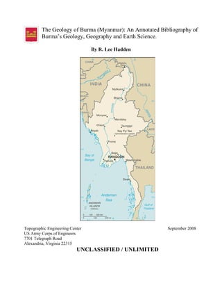
  • 3. Burma The Geology of Burma (Myanmar): An Annotated Bibliography of Burma’s Geology, Geography and Earth Science By R. Lee Hadden Topographic Engineering Center (TEC) Engineer Research and Development Center (ERDC) 7701 Telegraph Road Alexandria, VA 22315 September 2008 Robert.L.Hadden@us.army.mil Preface This bibliography was produced quickly by the Topographic Engineering Center (See: http://tec.army.mil/Burma/index.html) in response to the humanitarian crisis caused by the Cyclone Nargis which hit Burma in May 2, 2008. The cyclone packed winds of 215 km/hr (135mph) and with very heavy rains. The cyclone made landfall in Burma as a Category 4 cyclone, with catastrophic results, with estimates of 146,000 fatalities, and thousands more people missing, injured and homeless. These two images below are provided from NASA, and show the overwhelming amount of damage caused by Cyclone Nargis to Burma. Flood water can be difficult to see in photo-like satellite images, particularly when the water is muddy. This pair of images from the Moderate Resolution Imaging Spectroradiometer (MODIS) on NASA’s Terra satellite uses a combination of visible and infrared light to make the floodwaters obvious to the viewer. Water is blue or nearly black, vegetation is bright green, bare ground is tan, and the clouds are white or light blue. On April 15, 2008 (the top image), rivers and lakes are sharply defined against a backdrop of vegetation and fallow agricultural land. The Irrawaddy River flows south through the left-hand side of the image, splitting into numerous distributaries known as the Mouths of the Irrawaddy. The wetlands near the shore are a deep blue green. Cyclone Nargis came ashore across the Mouths of the Irrawaddy and followed the coastline northeast. The entire coastal plain of Burma is flooded in the May 5 image (the bottom image). The fallow agricultural areas appear to have been especially hard hit. For example, Yangôn (population over 4 million) is almost completely surrounded by floods. Several large cities (population 100,000–500,000) are in the affected area. Muddy runoff colors the Gulf of Martaban turquoise. The high-resolution image provided above is at MODIS’ maximum spatial resolution (level of detail) of 250 meters per pixel. The MODIS Rapid Response Team provides twice-daily images of the region in additional resolutions and formats, including photo-like natural color.
  • 4. Bibliography of Burman Earth Science September 2008 4 Relief efforts were slowed or non-existent as the Burmese military rulers initially refused aid from outside the country. By May 12-20, 2008, the US Department of Defense coordinated $1.2 million dollars of relief supplies on 36 USAF C-130 flights. The relief supplies would provide needed help to some 113,000 storm victims. Much more aid was needed. President George Bush also ordered the Essex group, composed of the USS Essex, the USS Juneau, the USS Harpers Ferry, and elements of the Third Marine
  • 5. Bibliography of Burman Earth Science September 2008 5 Expeditionary Force (III MEF), to stand by offshore with relief supplies, disaster engineering expertise and medical assistance. The Topographic Engineering Center (TEC) has scanned a number of geological and hydrological maps of Burma to assist the disaster planners on these ships and elsewhere. This data is used to select locations for supply dumps, emergency hospital locations, sanitation and clean water supplies. Other data on transportation and terrain helped with the airlifting of supplies, evacuating of the injured, and the prevention of bottlenecks in air, land and water traffic. The government of Burma refused permission for the US Navy and Marines to aid the survivors. The Essex group stood off the coast of Burma, waiting for permission to lend its support of supplies, helicopters and manpower, but it was never given. Although the humanitarian aid was refused, the TEC webpage has also helped civilian relief agencies in their efforts. The data is available around the world, and the US government, the United Nations and a number of non-governmental organizations have made use of this data in their humanitarian relief efforts. Copyrighted and sensitive materials have been placed behind the PKI site, and are available only to US government civilian and military personnel with CAC access. However, most of the information is from open sources, and thus is available to anyone. Special thanks are given to all those people outside of the Topographic Engineering Center who helped in this emergency project. They include the Reference Staff of the US Geological Survey Library who replied promptly to our requests and made their services so accessible (http://library.usgs.gov/); the public services staff of the Defense Technical Information Center (DTIC) who responded so quickly to our requests, and bent over backwards to make their information available online to the public (http://www.dtic.mil/dtic/index.html); the Reference Staff of the Geography and Map Division, The Library of Congress (http://www.loc.gov/rr/geogmap/) and to Mr. Willie Sayeed of RefWorks for the use of their services in putting together and updating the bibliography of citations from so many different electronic and manual resources so quickly (www.RefWorks.com). Introduction The Land: The country is known by several names: the conventional long form: “Union of Burma”; conventional short form: “Burma”; local long form: “Pyidaungzu Myanma Naingngandaw” (translated by the US Government as “Union of Myanma” and by the Burmese as “Union of Myanmar”); local short form: “Myanma Naingngandaw”; former: “Socialist Republic of the Union of Burma”. Note: since 1989 the military authorities in Burma have promoted the name Myanmar as a conventional name for their state; this decision was not approved by any sitting legislature in Burma, and the US Government did not adopt the name, which is a derivative of the Burmese short-form name Myanma Naingngandaw. The capital city is Rangoon (Yangon), with geographic coordinates: 16 48 N, 96 09 E. Strategically, Burma holds a strategic location near major Indian Ocean shipping lanes.
  • 6. Bibliography of Burman Earth Science September 2008 6 The time difference: UTC+6.5 (11.5 hours ahead of Washington, DC during Standard Time). Note: Nay Pyi Taw is actually the administrative capital. There are seven administrative division (taing-myar, singular - taing) and 7 states (pyi ne-myar, singular - pyi ne). The divisions are: Ayeyarwady, Bago, Magway, Mandalay, Sagaing, Tanintharyi, Yangon. The seven states are: Chin, Kachin, Kayah, Kayin, Mon, Rakhine and Shan. Burma lies in Southeastern Asia, bordering the Andaman Sea and the Bay of Bengal, between Bangladesh and Thailand. It is slightly smaller in land area than Texas, and has a total area of 678,500 sq km. Of this, land covers 657,740 sq km, and water covers 20,760 sq km. The national boundaries total: 5,876 km, with border countries boundaries of: Bangladesh at 193 km; China at 2,185 km; India at 1,463 km; Laos at 235 km and Thailand with a shared boundary of 1,800 km. There is also 1,930 km of coastline. The Physical Features of Burma1 Geology, Topology and Terrain As a country, Burma slopes downward in elevation from the north to the south, and is naturally divided into “Upper Burma” and “Lower Burma”. The terrain is made up of central lowlands ringed by steep, rugged highlands. In the north, the Hengduan Shan mountains form the border with China. Mount Hkakabo Razi, located in the Kachin State, is at an elevation of 5,881 m (19,295 ft), and is the highest point in Burma. The mountain ranges in Burma generally run from north to south as well. Three of these mountain ranges, namely the Rakhine Yoma, the Bago Yoma, and the Shan Plateau, all exist within Burma, and all of these ranges run from north-to-south from the Himalayas. These mountain chains also divide Burma's three main river systems, which are the Irrawaddy (aka Ayeyarwady), the Salween (aka Thanlwin), and the Sittang rivers. Burma's longest river, the Irrawaddy River, is nearly 2,170 kilometers (1,348 mi) long, and it flows through the country and into the Gulf of Martaban. Fertile plains exist in the valleys between the mountain chains. The majority of Burma's population lives in the Irrawaddy valley, which is situated between the Rakhine Yoma and the Shan Plateau. As a whole, Burma can be divided into five physiographic regions: the northern mountains; the western ranges; the eastern plateau; the central basin and lowlands, and finally the coastal plains. The northern mountain region consists of a series of ranges that form a geological complex at Mount Hkakabo. In terms of plate tectonics, this geological complex or “geologic knot” marks the northeastern limit of the encroaching Indian-Australian Plate. The Indian-Australian Plate has been colliding with the southern edge of the Eurasian Plate for roughly the past 50 million years, and has been thrusting up the mountain ranges 1 The data in this introductory section are collected from a number of open literature and common knowledge publications and resources, such as various almanacs, AGI’s “Glossary of Geology”, geographical dictionaries and gazetteers; encyclopedias such as the World Survey of Climatology, the Encyclopedia Britannica, Encarta, Water Encyclopedia, etc.; open source government publications and websites from the US Department of State, the Library of Congress, the Defense Technical Information Center, the Food and Agriculture Organization of the UN and others; the CIA Factbook, and several different reports, articles and books on Burma from federal government geological and geographical resources.
  • 7. Bibliography of Burman Earth Science September 2008 7 of Burma and the regions beyond. This northern mountain physiographic region contains the sources of several of Asia’s great rivers, including the Irrawaddy, which rises and flows wholly within Burma, and the Salween, which rises to the north in China. The upper courses of these rivers all flow through deep gorges within a short distance of each other, separated by steep, sheer peaks. Jade and other minerals are mined in these northern mountains. The western range region traverses the entire western side of Burma, from the northern mountains to the southern tip of the Rakhine (Arakan) Peninsula, where they run under the sea and then reappear above the ocean as the Andaman and Nicobar Islands, territories of India. The mountains’ average elevation is about 1,800 meters (6,000 feet), although some peaks rise in height to 3,000 meters (10,000 feet) or higher. These mountains consist of old crystalline rocks surrounded by hard, tightly folded sedimentary rocks on either side. From north to south, the Patkai Range, the Naga Hills, and the Chin Hills form the borders between India and Burma. To the south of these are the Rakhine Mountains (Arakan Mountains), which lie entirely within Burma and separate the coastal strip from the central basin. Occupying the eastern half of the country, the Shan Plateau is deeply dissected, with an average elevation of about 900 meters (3,000 feet). The Shan Plateau to the east rises abruptly from the central basin, often in a single step of some 600 meters (2,000 feet). Because of the geology of this region, rubies and sapphires have been mined in the northern Shan Plateau since pre-colonial times. Burma’s rulers depend on sales of these precious stones such as sapphires, pearls and jade to fund their regime. Rubies are the biggest earner; 90% of the world's rubies come from the country, whose red stones are prized for their purity and hue. Thailand buys the majority of the country's gems. Burma's “Valley of Rubies”, in the mountainous Mogok area, about 200 km (125 miles) north of Mandalay, and is noted for its rare pigeon's blood rubies and blue sapphires The Shan Plateau was formed during the Mesozoic Era, some 248 to 65 million years ago, and thus is a much older geologic feature than the western mountains. But the Shan Plateau also shows more-recent and intensive folding than the western mountains, with north-south longitudinal ranges rising steeply to elevations of 1,800 to 2,600 meters (6,000 to 8,600 feet) above the plateau surface. Northward, the plateau merges into the northern mountains, and southward it continues into the Dawna Range and to the peninsular Tenasserim Mountains (aka Tanintharyi Mountains), each a series of parallel ranges with narrow valleys. The central basin and lowlands, lying between the Rakhine Mountains and the Shan Plateau, are structurally connected with the folding of the western ranges. The basin was deeply excavated by the predecessors of the Irrawaddy, Chindwin, and Sittang rivers; the valleys are now occupied by these rivers, which cover the ancient soft sandstones, shales, and clays with their alluvial deposits. The Basin of the Irrawaddy, with its tributaries the Chindwin, Shweli, and Myitnge rivers, occupies most of Burma. In the delta regions formed by the Irrawaddy and Sittang rivers, the landscape is absolutely flat, and the monotony is relieved only by a few blocks of erosion-resistant rocks that are never more than 18 meters (60 feet) high. The basin is divided into two unequal parts, the larger Irrawaddy valley and the smaller Sittang valley. Between these two valleys are the Bago Mountains. In the centre of the basin and also structurally connected with the Bago Mountains and their northern
  • 8. Bibliography of Burman Earth Science September 2008 8 extension, is a line of extinct volcanoes with small crater lakes and eroded cones. The largest of these eroded volcanic cones is Popa Hill, at 1,518 meters (4,981 feet). The coastal areas consist of the narrow Rakhine and Tenasserim plains, which are backed by the higher ranges of the Rakhine and Tenasserim mountains. These coastal regions are fringed with numerous islands of varying sizes. As to economic geology, Burma is rich in certain minerals, including metal ores, petroleum, and natural gas. Deposits of silver, lead, zinc, and gold are concentrated in the northern Shan Plateau; tin and tungsten in the Tenasserim region, and barite around the town of Maymyo in the central basin. Copper mining at the town of Monywa began in the early 1980s and has been growing, despite intermittent setbacks caused by shortages of fuel and supplies as well as by economic sanctions imposed by foreign governments. Large-scale exploitation of Burma’s mineral deposits began in the mid-1970s. Although production generally has been increasing since the late 20th century, mining accounts for only a tiny fraction of the country’s GDP and a comparable portion of the workforce. The country also has significant deposits of precious and semi-precious stones. Burmese rubies are internationally known for their deep color and quality. The country also produces smaller quantities of spinels2 , diamonds, and other gemstones. Weather and Climate Although Burma is located in the monsoon region of Asia, its climate is greatly modified by its geographic position and its topographical relief. The cold air masses of Central Asia bring snow to the northern mountains for two months of the year, but this mountain wall prevents the cold air masses from moving farther south, so that Burma lies primarily under the influence of the monsoon winds. The north-south alignment of ranges and valleys also creates a pattern of alternate zones of heavy and scanty precipitation during both the northeast and southwest monsoons. Most of the precipitation, however, comes from the southwest monsoon. The west coast is subject to occasional tropical cyclones. Most of Burma lies between the Tropic of Cancer and the Equator. The Tropic of Cancer divides the country into two regions: the tropical south that covers two-thirds of the country, and the sub-tropical and temperate north, which is the remaining one-third of Burma. This causes two distinct seasons: the dry season from mid-October to Mid-May, and the wet season. There is a cooler spell during the wet season from December to February. The coastal regions and the western and southeastern ranges receive more than 200 inches (5,000 mm) of precipitation annually, while the delta regions receive about 100 inches (2,500 mm). The central region is not only positioned away from the sea but also on the drier, lee side- in the rain shadow- of the Rakhine Mountains. Precipitation gradually decreases northward until in the region’s dry zone it amounts to only 20 to 40 2 Probably named from the Latin word "spina", (meaning "thorn"), for its pointed (octahedral) crystals. Spinel is a hard mineral with octahedral crystals found in igneous and carbonate rocks. Spinel occurs typically as a contact metamorphism of impure dolomitic limestone, and less commonly as an accessory mineral of basic igneous rocks. Spinal also occurs in alluvial deposits. It consists essentially of alumina and magnesia (MgAl2O4), but commonly contains ferrous iron and sometimes also chromium. It is found in a variety of colors including blue, green, brown, black, and the valuable red variety which resembles a ruby, and is frequently used as a gemstone.
  • 9. Bibliography of Burman Earth Science September 2008 9 inches (500 to 1,000 mm) per year. The Shan Plateau, because of its elevation, usually receives between 75 and 80 inches (1,900 and 2,000 mm) annually. Monsoons As said above, Burma also lies in the monsoon region of Asia, with its coastal regions receiving over 5,000 mm (200 in) of rain annually. Annual rainfall in the southern delta region is approximately 2,500 mm (100 in), while average annual rainfall in the Dry Zone, which is located in central Burma, is less than 1,000 mm (40 in). Burma has a monsoon climate with three main seasons: the hot period, the rainy season and the cooler period. The hottest period is between February and May, with little or no rain. At the end of this season, generally from March to April, the average monthly temperature reaches the upper 30°s C (lower 100°s F) in many parts of Burma. The average daily temperatures in Yangon (Rangoon) range from 24° to 36°C (75 to 97°F) in April, during the hot season. The climate of Burma and other countries in South and Southeast Asia follows a typical monsoon pattern. During the half of the year that the sun’s rays strike directly above the equator, the land mass of Asia is heated more than is the Indian Ocean. This draws moist hot air from over the ocean onto the land, bringing the rains of the southwest monsoon season. The Monsoon or Rainy season, also called “the hot and wet season”, exists usually from May to October. In Burma during this hot and wet season, rain usually falls nearly every day and sometimes all day long, and almost all of Burma’s annual rainfall occurs during this time. Rainfall during the monsoon season totals more than 500 cm (200 in) in upper Burma and over 250 cm (100 in) in lower Burma and Yangon (Rangoon). Central Burma, called the dry zone, and Mandalay, the chief city in this area, each receive about 76 cm (30 in). By July rains have brought the average temperature down to 29°C (84°F) in Mandalay and 27°C (81°F) in Yangon. Average annual rainfall during this season varies from about 5,000 mm (about 200 in) on the Tenasserim Coast to about 760 mm (about 30 in) at Mandalay. The country receives practically all its rainfall between mid-May and October, the period of the Southwest Monsoon. Annual precipitation in most of Upper Burma averages about 890 mm (about 35 in) and in Lower Burma about 5080 mm (about 200 in). The climate is tropical monsoon, with cloudy, rainy, hot and humid summers during the height of the southwest monsoon season, from June to September. When the tilt of the earth brings the direct sun rays south of the equator, the heating of the Indian Ocean draws the cooler dry air of the northeast monsoon from the highlands of Asia across the countries of South and Southeast Asia. The dry, cooler weather is from October/November to February. The hot, dry inter-monsoonal season is from mid-February to mid-May. The country is less cloudy, with scant rainfall and mild temperatures and lower humidity during the winter. This is the time of the cool, relatively dry northeast monsoon. In this cooler season, which runs from late October to mid-February, the temperature for January averages 25°C (77°F) in Yangon in Lower Burma and 20°C (68°F) in Mandalay in Upper Burma. The average daily temperatures in Yangon (Rangoon) range from 18° to 32°C (64-90°F) in January, during this cooler season.
  • 10. Bibliography of Burman Earth Science September 2008 10 In Burma, the mean annual temperature is 27°C (81°F). Although Burma is a tropical country, temperatures are not uniformly high throughout the year and throughout the country. The daily temperature range in Burma is greater than that temperature range in nearly all other parts of Southeast Asia. But no region in Burma has a continental type of climate (i.e., one characterized by large seasonal differences in average temperature). However, the average daily temperatures in Burma show little variation across the country, ranging from 26 °C to 28 °C (79 °F to 82 °F) between Sittwe in the Rakhine region, Yangon near the coast, and Mandalay in the northern part of the central basin. At Lashio, on the Shan Plateau, the average daily temperature is somewhat cooler, around 22 °C (71 °F). Elevation and distance from the sea affect temperature as well, and temperatures are generally lower in Burma’s mountainous regions. The northern regions of Burma are the coolest in the country, with average temperatures of 21°C (70°F). Thus the climate in upper Burma, especially at altitudes ranging from about 300 to 1,220 meters (1,000– 4,000 ft) of elevation, remains the most temperate throughout the year. Mandalay, in the centre of the dry zone, has some of the greatest daily temperature ranges, which span about 12°C (22°F) annually. Lower Burma, especially in the river delta and along the coastal regions, is the most humid part of the country. The coastal and delta regions have a mean annual temperature of 32°C (90°F). Surface and Ground Water Resources The water resources in Burma from 1999 include 1,045.6 cubic kilometers of total renewable water resources. Freshwater withdrawal for domestic, industrial and agricultural use, totals about 33.23 cu km/yr (1%/1%/98%); per capita water withdrawal in 2000 is about 658 cu m/yr. Environmentally, Burma suffers from deforestation and the industrial pollution of air, soil, and water. Also the inadequate sanitation and water treatment contribute to disease. Like the mountains, Burma’s main rivers run mainly from north to south. About three-fifths of the country’s surface is drained by the Irrawaddy River and its tributaries. The Rakhine coastal plains are drained by short, rapid streams, which, after forming broad river deltas, flow into the Bay of Bengal. The Tenasserim plains also are drained by short and rapid rivers, which enter the Gulf of Martaban. The Bassein River, also known as the Pathein River, drains the southern Rakhine Mountains. The Bassein River is about 257 kilometers (160 miles) long, and is chiefly a navigable outlet of the Irrawaddy River in the western part of the delta. Chindwin River: The great tributary of the Irrawaddy, the Chindwin, is about 1,158 km (750 miles) long, and drains the western region. The Chindwin River (Burmese: Chindwin Myit) is the largest tributary of the Irrawaddy River. It flows entirely within Burma and is known as “Ning-thi” to the Manipuris. The Chindwin rises in the Kumon Range in northern Burma, and flows northwest through the Hukawang Valley, then south along the Indian border and then southeast to the Irrawaddy River at Myingyan. The Chindwin is navigable for some 500 miles (800 km) from its confluence with the Irrawaddy below Mandalay to the confluence with the Uyu River, its chief tributary.
  • 11. Bibliography of Burman Earth Science September 2008 11 The Chindwin is served by regular river-going vessels up to the town of Homalin. Much of Chindwin's course lies in the within mountain ranges and forests. Due to the difficulty of access, much of the un-navigable river area remains unspoiled. The government of Burma recently created a very large (2,500 square mile) sanctuary for the endangered tiger within the Hukawng Valley. Teak forests within the drainage area have been a valuable resource since ancient times. The Hukawng Valley is known for its abundance of Burmese amber. Along the river, there are also deposits of jade, but the best jade is found in the region around the headwaters of the Uyu river. The Irrawaddy River: The country’s trade in rice is dependent on water transport, and the Irrawaddy River is the backbone of Burma’s transportation system. The Irrawaddy River starts in the North of Kachin State, at the confluence of the Mali Hka and N'Mai Hka rivers north of Myitkyina. The western Mali Hka branch arises from the end of the southern Himalayas, north of Putao, and, like the main river, is called “Nam Kiu” in the Shan language. The river then flows south through Burma to the Bay of Bengal through several mouths near Rangoon. Flowing entirely through Burma, the Irrawaddy is about 2,092 km long (1,300 miles), and it is navigable year round for nearly 1,000 miles (1,600 km) up to the junction with the Bhamo, the main tributary of the Chindwin River. The Irrawaddy River bisects the country from north to south and empties into the Indian Ocean through a nine-armed Irrawaddy Delta. In colonial times, before railways and automobiles, the river was known as the “Road to Mandalay”. Although navigable by large vessels to Myitkyina for a distance over 1,600 km from the ocean, the river is also full of sandbanks and islands, making such navigation difficult. For many years, the only bridge built to cross the Irrawaddy River was the Inwa Bridge. At the apex of its delta, the Irrawaddy breaks up into a vast network of streams and empties into the Andaman Sea through multiple mouths. The many streams of the Irrawaddy delta are navigable, and there is a regional system of inter-connecting canals. The Kaladan River is a river located in the west of the country around the Sittwe area. The Burmese government was working on a $500 million project in cooperation with India to attempt to facilitate river trade between the two nations. The Kaladan River trade will open up not only Mizoram but India's entire North East as a hinterland for the Burma port of Sittwe. Development of the river is also being negotiated with the Shwe Gas Project for economic enhancement. The Kok River originates in Shan State, Burma. It flows down and across the Burma-Thailand border to Mae Ai district, Chiang Mai Province. Most of its length is in Chiang Rai Province passing the districts Mueang Chiang Rai, Mae Chan, Chiang Saen and Wiang Chai. It becomes a tributary to the Mekong River in Chiang Saen district. The Mali River (Mali Hka) is a river that originates in northern Burma. It flows approximately 320 km, when it meets with the Nmai River and their confluence forms the Irrawaddy River. The Mekong is one of the world’s major rivers. It is the 11th-longest river in the world, and 7th longest in Asia, discharging 475 km3 /114 cu mi of water annually. Its estimated length is 4,350 km (2,703 mi), and it drains an area of 795,000 km2 (307,000 square miles). From high in the Tibetan Plateau, the Mekong runs through China's Yunnan province, then through Burma, Thailand, Laos, Cambodia and Vietnam. All the other countries except China and Burma belong to the Mekong River
  • 12. Bibliography of Burman Earth Science September 2008 12 Commission. The extreme seasonal variations in flow and the presence of rapids and waterfalls have made navigation extremely difficult along the river. The Moei River is a tributary of the Salween River. It originates in Phop Phra district, Tak Province. Unlike most rivers in Thailand, the Moei flows north. The river forms the natural border line between Thailand and Burma. The districts along the Moei River bank of Thailand, from South to North are Mae Sot, Mae Ramat, Tha Song Yang and finally it enters the Salween River in Sop Moei district of Mae Hong Son Province. The river is about 327 km long. The Rangoon River, also known as the Yangon River, is about 40 km long (25 miles), and flows from southern Burma as an outlet of the Irrawaddy River into the Irrawaddy delta. The Rangoon River drains the Bago Mountains; both the Rangoon and the Bassein Rivers enter the Irrawaddy at the delta. The Ruak River is a river along the Thai-Burma border. It originates within the hills of the Shan State of Burma, and becomes the boundary river between Thailand and Burma at the confluence with the Mae Sai River at the northernmost point of Thailand. It then meanders to the east until it empties into the Mekong River at Ban Sop Ruak, Tambon Wiang, Chiang Saen district, Chiang Rai Province. The boundary section of the river is 26.75 km long. The Shan Plateau is drained by the Salween River, which enters Burma from southern China and empties into the Gulf of Martaban southeast of the Sittang. The Salween rises in the Plateau of Tibet, and then flows east through Sichuan, then south through the western Yunnan province of southwestern China. The Salween is about 2,415 km long (1500 miles). Many of its tributaries are more than 480 km (300 miles) long and join the Salween in cascades. The river continues south through Burma, and its lower course becomes part of the boundary between Thailand and Burma. The river empties into the Gulf of Martaban at Moulmein. The Salween River, because of its rapids, is navigable for less than 160 km (100 miles) from the sea. The Salween River is deeply entrenched and crosses the Shan Plateau in a series of deep gorges. It is home to over 7,000 species of plants and 80 rare or endangered animals and fish. UNESCO said this region “may be the most biologically diverse temperate ecosystem in the world” and designated it a World Heritage Site in 2003. The Salween is the longest undammed river in mainland Southeast Asia. Proposals to build several dams along the river, mainly in Burma, are controversial. Thailand is studying the feasibility of jointly constructing the Hatgyi Dam on the Salween River near the border with Burma; citing environmental, cultural, and social concerns, China is reconsidering construction of 13 dams on the Salween River but energy-starved Burma with backing from Thailand remains intent on building five hydro- electric dams downstream, despite identical regional and international protests. The Sittang River flows into the Gulf of Martaban of the Andaman Sea. The Sittang flows in east central Burma, and then flows south to the head of the Gulf of Martaban. The river is about 418 km long (260 miles) and, for a comparatively short river, it has a large valley and delta. Although the Sittang River flows through fairly flat country, the Sittang has a notorious tidal bore at its mouth which has precluded any but very small craft navigating the river. Strong currents make the river even less valuable as a means of transport in eastern Burma. The Sittang, in spite of its silt, is usable by smaller boats, but its basin
  • 13. Bibliography of Burman Earth Science September 2008 13 does not have the same richness for agriculture as the Irrawaddy because there is no soil flowing from the Himalayas. The Zawgyi River is a river of eastern Burma. It flows through the foothills of the Shan Mountain range in Shan State. Burma has two major lakes. The Indawgyi Lake, in the northern hills, runs some 24 km (15 miles) from north to south and 13 km (8 miles) from east to west. The Indawgyi is one of the largest natural inland lakes of Southeast Asia. Somewhat smaller is Inle Lake, stretching about 22 km (14 miles) from north to south and 11 km (7 miles) from east to west, is located on the Shan Plateau. The Inle Lake is fed by dozens of streams.
  • 14. Bibliography of Burman Earth Science September 2008 14 Geography The life expectancy in Burma is: Male 58 years; Female 63. Hospitals 1:1,586. The literacy rate is 78%. The major ethnic groups in Burma are: Burman 68%, Shan 9%, Karen 7%, Rakhine 4%, Chinese 3%, Indian 2%, Mon 2%, other 5%. Complicating national unity, over half of Burma's population consists of diverse ethnic groups who have substantial numbers of kin living in neighboring countries. Thailand must deal with Karen and other ethnic refugees, asylum seekers, and rebels, as well as illegal cross-border activities from Burma. India also seeks cooperation from Burma to keep Indian Nagaland separatists, such as the United Liberation Front of Assam, from hiding in the remote Burmese Uplands. Image taken from: “Burma: A Country Study.” 1984. Foreign Area Studies, the American University. 3rd edition. US GPO.
  • 15. Bibliography of Burman Earth Science September 2008 15 The Burmans, who form the largest ethnic group, account for more than half of the population. They are concentrated in the Irrawaddy River valley and in the coastal strips, with an original homeland in the central dry zone. The Shans (shahns) are about 9% of the population. “Once the masters of the Burmans when they ruled after the collapse of the Pagan-based monarchy, the Shans have no historical inferiority complex. In the centuries after the Pagan period, the Shans developed their own monarchies where Shan mandalas of power oscillated constantly as more powerful Burmese and Thai kings contested each other. Deference to outside royalty was a small price to pay for considerable Shan independence internally. The Shans in 1983 were basically rice farmers, skillful traders, and a valley people. In matters of governance, historically they have allowed an aristocratic elite to rule them.” The Shan of the Shan Plateau have little ethno-linguistic affinity with the Burmans, and, although historically led by hereditary rulers, their society was less elaborately structured than that of the plains peoples. The Shan represent a small but significant portion of the country’s population. The ethnographic complexity of the highlands occasionally leads to mis-groupings of some of the smaller communities with their more prominent neighbors. For example, the Wa and the Palaung of the Shan Plateau are often grouped with the larger, but ethnically and linguistically distinct, Shan community. The Karen ethnic group is about 7% of the Brumese population. “It has been fashionable to call the traditional religion of people like the Karens a form of animism, or ‘spirit worship.’ The word never does justice to such beliefs, which may be as complex and lofty as those of the major religions of the world. Traditional Karens, like so many other peoples, believe that both matter and spirit are realities, each possibly inhabiting the same entity at a given time or perhaps later separated but still linked. There are Karen gods, rituals, and oral religious traditions so impressive that early missionaries toyed with the belief that the Karens were a lost tribe of Israel. No matter where Karens live, they characteristically have a strong sense of ethnic pride.” The Karen are the only hill people who have settled in significant numbers in the plains. Constituting about one-tenth of the population, they are the second largest ethnic group in Burma. They are found in the deltas among the Burmans, in the Bago Mountains, and along both sides of the lower Salween River. The Kayah, who live on the southern edge of the Shan Plateau, were once known as the Red Karen, or Karenni, apparently for their red robes. Although ethnically and linguistically Karen, they tend to maintain their own identity and hereditary leadership. The Chin (pronounced “JIN”): In the western hills and the Chindwin River valley are various groups called by the comprehensive name of Chin. “Turbulent, competitive, legalistic, and yet very social, the Chins did not take to Christianity as well as did the Karens. Like the Karens, those who are Christians (possibly one-quarter of the population) have hoped to use their new faith to link with outside powers to protect their people from being engulfed by Burmans. The Chin religion, in which the door to paradise is opened by hinting done in the proper way to honor and contend with the spirits of what is killed, can be seen in contrast to the Buddhism of their neighbors, where taking life is normatively scorned. Animal sacrifice, so common among hill peoples, is likewise condemned by valley Buddhists.” The Naga on the Burma side of the frontier with India sometimes are mistakenly placed with the Chin
  • 16. Bibliography of Burman Earth Science September 2008 16 Numerous small ethnic groups, most of which inhabit the upland regions, together account for roughly one-fifth of Burma’s population. The upper Irrawaddy valley and the northern hills are occupied by groups under the comprehensive name of Kachin. These peoples long have had an association with the Burmans. The Muhso (a Lahu people) in northeastern Burma are sometimes grouped with the Kachin. Chinese, Indians, and other minorities in Burma: “Since only people who can prove long familial links to Burma are accorded full citizenship, ethnic populations such as Muslims, Indians, and Chinese, continued to be denied full citizenship and to be excluded from government positions. People without full citizenship are not free to travel domestically and are barred from certain advanced university programs in medicine and technological fields. Anti-Chinese and anti-Muslim sentiment remained pervasive.” Religions The major religions of the country are: Buddhist 89%, Christian 4% (Baptist 3%, Roman Catholic 1%), Muslim 4%, animist 1%, other 2%. Theravada Buddhism: “In strict orthodox Theravada Buddhism, Gotama (Siddhārtha Gautama) was merely a human being; he does not exist anywhere to hear people’s prayers. His words are left in the sacred books and can be learned from his ‘sons,’the living Theravada monks, who exist today as the Buddha once instructed the first monks to live. All Burmans share in this heritage and follow some semblance of the strict orthodox teachings. The Buddhism of the Pali scriptures, however, often differs from actual religious beliefs and practices in modern Burma.” (all quotations are from the Library of Congress Country Studies/Area Handbook--Burma [Myanmar]) Hinduism: Burma has a substantial number of Hindu adherents in Rakhine. However, many Burmans remember the use of Indian soldiers to colonize and conquer Burma, and thus are looked upon unfavorably by the majority. Also, many of the Buddhist beliefs claim superiority over Hinduism, and the traditional Hindu gods are relegated to godlings who must be reborn as Buddhist humans. Islam: “The historically porous border between Burma and Bangladesh and India has been the source of perpetual movement of Muslims back and forth in response to their various political fortunes. Although the potential was always there for Buddhist- Muslim confrontation, in general the two groups have managed to live peaceably side by side but without much interaction.” Mosques are found in Arakan, Rangoon, and in all areas where the Muslim community is strong, some of these groups having established themselves in Burma centuries ago. Mosques are primarily found within the Rakhine State. Like the Hindu and Chinese populations, Muslims have to keep a low profile in terms of asserting their ethnic identity in order to avoid the racial antagonism that has often flared up in the past.” (Human Rights Report...) Christian: Many Chins, Kachins, Karens and others are Christian. “Minorities in Burma face a Buddhist majority, and Christianity remains an option for asserting one’s distinctness, not only for the Karens or Chins, for example, but also for those who have had a genuine Christian conversion and for others who retain a fierce loyalty to all things British. On a visit to Mandalay, a visitor attempting, however ineptly, to speak Burmese should not be surprised to have an impeccably dressed older man watch for a while with a smile and then speak in exquisite English with a perfect Oxford accent. The same elderly
  • 17. Bibliography of Burman Earth Science September 2008 17 gentleman will finish his days as an ardent Christian. No revolution will convert him into either a Buddhist or a socialist.” Languages The majority language is Burmese, though minority ethnic groups have their own languages. Many indigenous languages—as distinct from mere dialects—are spoken in Burma. The official language of the country is Burmese, spoken by the people of the plains and, as a second language, by most people of the hills. During the colonial period, English became the official language, but Burmese continued as the primary language in all other settings. Both English and Burmese were compulsory subjects in schools and colleges. Burmese, Chinese, and Hindi were the languages of commerce. After independence English ceased to be the official language, and after the military coup of 1962 it lost its importance in schools and colleges; an elementary knowledge of English, however, is still required, and its instruction is again being encouraged. The local languages of Burma belong to three language families. Burmese and most of the other languages belong to the Tibeto-Burman subfamily of Sino-Tibetan languages. The Shan language belongs to the Tai family. Languages spoken by the Mon of southern Burma and by the Wa and Palaung of the Shan Plateau are members of the Mon-Khmer subfamily of Austro-Asiatic languages. Speakers of Burmese and Mon historically have lived in the plains, while speakers of a unique dialect of Burmese (that perhaps retains some archaic features of pronunciation) have occupied the Rakhine and Tenasserim coastal plains. The hills were inhabited by those speaking Shan, Kachin, Chin, and numerous other languages. In the plains the ancient division between northern and southern Burma (Upper Burma and Lower Burma, respectively) was based not only on geographic differences but also on a linguistic one. The Mon (now a small minority) lived in southern Burma, while the majority Burman population lived in the northern dry zone. Until colonial times only Burmese, Mon, Shan, and the languages of the ancient Pyu kingdom of northern Burma were written. Writing systems for the languages of the Karen, Kachin, and Chin peoples were developed later.
  • 18. Bibliography of Burman Earth Science September 2008 18 Land Use The area of arable land in Burma during 2005 was 14.92% of the country, with permanent crops: 1.31% and other uses: 83.77%. In 2003, there were 18,700 sq km of irrigated land. The major agricultural products of Burma are rice, pulses, beans, sesame, groundnuts, sugarcane; hardwood; fish and fish products. According to official estimates, about half of Burma remains covered with forests or jungles of various types (depending on elevation and the amount of precipitation). Even after centuries of rice cultivation involving the clearing of forested areas, large tracts of forest remain, but actual coverage may be less than estimated, however. Subtropical and temperate forests of oak and pine are found at elevations above 3,000 feet (900 meters). In the northern mountains, above 6,000 feet (1,800 meters), are forests of rhododendrons. Elephants are numerous in Burma, and many are trained for work, especially in the timber industries. Tigers, leopards, and wildcats are still common in the wild. Some bears are found in the hilly regions, and gibbons and monkeys of various kinds inhabit the thicker parts of the forests. Tropical evergreen rainforests of hardwood trees occur in areas receiving more than 2,000 mm (80 inches) of rain annually. In regions where the rainfall is between 1,000 and 2,000 mm (40 and 80 inches) are found broad-leaved tropical-deciduous monsoon forests, the trees of which shed their leaves during the hot season. They produce valuable woods, notably teak. The jungles of Burma are home to a profusion of birdlife, including grouse, pheasants, parrots, peafowl and other wild fowl. The Asian two-horned rhinoceros (Dicerorhinus sumatrensis), the wild water buffalo, the gaur (a species of wild cattle), and various kinds of deer were once plentiful but they are now reduced in number and are protected. Where rainfall is less than 40 inches, the forests gradually open into scrubland. There are no true grasslands in Burma, but bamboo, bracken (ferns), and coarse grass grow in areas where the forest has been cleared and then abandoned. Snakes include pythons, cobras, and vipers, and crocodiles are found in the deltas. Turtles live in coastal regions, and edible fish abound in every stream. The country of Burma can be divided into three distinct agricultural regions: the Irrawaddy river delta, where cultivation of rice in flooded paddies predominates; the largely irrigated dry zone, an area primarily of rice production but where a wide variety of other crops also are raised; and the hill and plateau regions, where forestry and cultivation of rice and other crops through shifting agriculture are most important. Delta The delta’s traditional agriculture consisted primarily of rice in normal years, with the substitution of millet in drier years or when there was insufficient moisture for rice. Both millet and rice yielded good returns on the alluvial soils. Although the dry zone was Burma’s most important agricultural region in the past, the rice production of the Irrawaddy River delta now provides much of the country’s export earnings and the staple diet of the country’s people. In the Irrawaddy and Sittang river deltas are also found tidal forests of mangrove trees that grow as high as 30 meters (100 feet) and these trees supply firewood and bark for tanning.
  • 19. Bibliography of Burman Earth Science September 2008 19 The lowland regions are covered with alluvial soils- mainly silt and clay. Low in nutrients and organic matter, the planted soils are improved by fertilizers. Burma’s richest soils are found in a narrow alluvial strip along the Bay of Bengal, where mountain streams irrigate the land in the wide Irrawaddy and Sittang river valleys. These deep soil deposits form a vast, fertile belt especially suitable for rice cultivation because of the abundant moisture. Dry Zone The Dry Zone covers approximately 8,718,898 hectares or about 13% of the country's total land area, and is situated in the lower Sagaing, Mandalay and Magway Divisions. Based on mean annual precipitation rates the Dry Zone covers 13 administrative districts and 57 townships. The topography is generally undulating. Most of the local streams are dry for much of the year with water flow is usually limited to the rainy periods. Crops grown in the dry zone, in addition to rice and millet, include sugarcane, fruits (such as plantains), legumes, peanuts or groundnuts, maize, onions, sesame, rubber, and allspice. To cultivate much of this land successfully, however, irrigation is required. The earliest known irrigation works were constructed in the 1st century and greatly improved during the 11th century. Although the irrigation system maintenance lapsed somewhat after the fall of the monarchy in the late 19th century, many of the ditches and streams are still in active service. As in the delta, the arrival of the British in the dry zone led to increased commercial and public-works activities. British authorities repaired and extended parts of these ancient systems during the early 20th century. Most of Burma’s irrigated land is in the dry zone, and almost all of it is planted in rice. The portions of the dry zone that are not irrigated are utilized for the production of crops that are less sensitive to the seasonality or irregularity of rainfall than rice. In addition to the crops mentioned above, cotton and millet are cultivated, although neither is of considerable significance. Cattle also are raised there. The Dry Zone townships are characterized by clay, sandy loam and sandy soils that include gravel. The soils clearly vary with topography. According to soil survey data, all soil series in the Dry Zone have low fertility and have declining organic matter levels. Potassium levels are also low for agriculture. Nitrogen is required for all non-legume crops on all soil types. This also suggests the consistent low organic matter level in the soil. The soil moisture holding capacity of the soils of the Dry Zone are low and with the high level of evapotranspiration, impacts agriculture. This lack of moisture in the ground constitutes a major constraint to crop growth during periods of inadequate rainfall, such as in June and July. Farm management practices that conserve soil moisture or increase the water holding capacity of the soils are being practiced to help take advantage of the full growing season. Hard pan formation is common to all the upland areas. In the dry belt of the central region are found red-brown soils rich in calcium and magnesium. In the same region, however, when the soil has a low clay content, and it becomes saline under high evaporation that is recognizable by its yellow or brown color. Soil erosion is a serious problem and in some places in the Dry Zone the soil has been almost completely removed by water and wind erosion. Soil erosion is particularly
  • 20. Bibliography of Burman Earth Science September 2008 20 severe in the upland areas of Kyaukpadaung and Chaung U, largely as a result of the high intensity of rainfall and rapid surface runoff. Moreover, since most of the soil in these areas is moderately textured with a slope ranging from 5-15%, the erodibility of the soil is also high. In Chaung U, the most severe erosion occurs in the upland areas. In contrast, the incidence of soil erosion in the foot plain is lower. Sheet and rill erosion and vertical dissection are widespread, resulting in an uneven topography. In Magway, because of the sandy topsoil there is also a high level of erosion. The susceptibility of the soil to erosion is compounded by the high level of rainfall occurring over short periods. Wind erosion is a particularly severe problem while sheet and gully erosion are largely confined to wasteland areas. Soil erosion and land degradation are the two components responsible for declining production potential. Hill and Plateau Country The third agricultural zone, the hill and plateau country, occupies perhaps two- thirds of the area of Burma. This land has less economic significance than the other two zones; it is the home of many of the country’s non-Burman ethnic groups, most of whom are engaged in shifting cultivation. More-sedentary modes of agriculture also exist, however, and have been imposed with the advance of agricultural technology, increased population, and central planning. The highland regions of Burma are covered with highly leached, iron-rich, dark red and reddish brown soils. When protected by forest cover, these soils absorb the region’s heavy rain, but they erode quickly once the forest cover has been cleared. Outside the forest areas of these highlands, the principal crops raised are rice, yams, and millet, and large numbers of pigs and poultry are kept. Bullocks and buffalo are used as draft animals, and goats, pigs, and poultry are raised for food in all parts of the country.
  • 21. Bibliography of Burman Earth Science September 2008 21 Myanmar Dominant Soils. Geographical distribution of 10 dominant soil types in Myanmar. Map created by FAO/NRL from Harmonized World Soil Database (HWSD) – FAO
  • 22. Bibliography of Burman Earth Science September 2008 22 Economy Burma is one of the poorest nations in southeastern Asia, suffering from decades of stagnation, mismanagement and isolation. Burma's GDP grows at an average rate of 2.9% annually – the lowest rate of economic growth in the Greater Mekong Sub-region. Agriculture, forestry, and fishing together constitute the largest contributor to Burma’s economy. About half of all agricultural land in Burma is devoted to rice, and to increase production the government has promoted multiple cropping (sequential cultivation of two or more crops on a single piece of land in a single year), a system that is easily supported by the country’s climate. As a whole, the sector accounts for nearly one-half of the country’s gross domestic product and employs about two-thirds of the labor force. The second most important element in the diet, after rice, is fish, either fresh fish or in the form of ngapi, a sort of nutritional paste that is prepared in a variety of ways and eaten as a condiment. Marine fisheries are not well developed, although the industry’s reported commercial catch is much greater than that reported from inland waters. Much private, noncommercial fishing is provided, however, in virtually every type of permanent, seasonal, or artificial body of inland water of any size. Non-indigenous fish, including the European carp and the tilapia, originally brought from Thailand, have become the focus of a growing aquaculture industry. Under British administration and until the early 1960s, Burma was the wealthiest country in Southeast Asia. It was once the world's largest exporter of rice. After Burma was officially annexed to British India in 1886, however, colonial policy called for a more commercially oriented and more extensive cultivation of rice. Since the indigenous labor force was thought to be insufficient to support the colonial export economy, the immigration of Indian and Chinese laborers into Burma was officially encouraged during the early decades of the 20th century. Despite the departure of much of the immigrant labor force and the relatively low growth in rice production after World War II, rice remained both the basic food and, until the 1990s (when it was overtaken by dry beans), the principal agricultural export of Burma. Also during the British administration, Burma supplied oil through the Burmah Oil Company. Burma also had a wealth of natural and labor resources. It produced 75% of the world's teak and had a highly literate population. The country was believed to be on the fast track to development. After a parliamentary government was formed in 1948, Prime Minister U Nu attempted to make Burma a welfare state. His administration adopted the Two-Year Economic Development Plan, which was a failure. The 1962 coup d’état was followed by an economic scheme called the “Burmese Way to Socialism”, a plan to nationalize all industries, with the exception of agriculture. In 1989, the Burmese government began decentralizing economic control. It has since liberalized certain sectors of the economy, although lucrative industries of gems, oil and forestry remain heavily regulated. These industries have recently been exploited by foreign corporations and governments which have partnered with the local government to gain access to Burma's natural resources. The major occupations in Burma are in agricultural processing; wood and wood products; copper, tin, tungsten, iron; cement, construction materials; pharmaceuticals; fertilizer; natural gas; garments, jade and gems. The labor force in 2001 was 70% in agriculture; 7% in industry and 23% in services.
  • 23. Bibliography of Burman Earth Science September 2008 23 Transportation Airports. There are 86 airports in Burma in 2007. There are 25 airports with paved runways over 3,047 meters long; 8 airports with paved runways from 2,438 to 3,047 meters long; 10 airports with paved runways from 1,524 to 2,437 meters long; 5 airports with paved runways from 914 to 1,523 meters long and one airport that has a runway that is under 914 meters long. Airports with unpaved runways total 61. Airports with unpaved runways over 3,047 m: 1; airports 1,524 to 2,437 m: 14; airports 914 to 1,523 m: 14; and those airports with unpaved runways under 914 m: 32. In 2007, there were four heliports listed in Burma. The state-run Burma Airways International runs frequent domestic flights between Yangon and other cities; it also has international service from Yangon to several major Southeast Asian cities. There are also small privately owned airlines that offer domestic and very limited international service. International airports are located only in Yangon and Mandalay. Railroads in Burma are old and rudimentary, with inadequate and few repairs since their construction in the late nineteenth century. Railways total 3,955 km of narrow gauge track and 3,955 km of 1.000-m gauge in 2006. The first railway line, running from Yangon to Pyay (Prome) and built in 1877, followed the route of the Irrawaddy River valley. The line was not extended to Mandalay; instead, after 1886 a new railway from Yangon up the Sittang valley was constructed, meeting the Irrawaddy at Mandalay. From Mandalay it crossed the river and, avoiding the Irrawaddy valley, went up the Mu River valley to connect with the Irrawaddy again at Myitkyina. A short branch line railroad now connects Naba to Katha on the Irrawaddy below Bhamo. The Yangon-Mandalay-Myitkyina railway is the main artery, and from it there are branch lines connecting the northern and central Shan Plateau with the Irrawaddy. Other branches run from Pyinmana across the Bago Mountains to Kyaukpadaung and from Bago to Mawlamyine to Ye. The Pyay-Yangon railway has a branch crossing the apex of the delta to Hinthada and Pathein (Bassein). Roads and highways are normally unpaved, except in the major cities. About 78 percent of the main roads are paved, with about two-thirds of the roads constructed of gravel, and the rest passable most easily only by jeep or ox cart. In 2005, there were a total of 27,000 km of roadways in Burma, of which 3,200 km are paved and 23,800 km are unpaved. The road system, until independence, was confined to the Irrawaddy and Sittang valleys, and effectively duplicated the railway route. There are extensive road links and several bridge links with Thailand and China. A road goes from Pyay along the Irrawaddy to the oil fields, and many other roads extend into the rural areas. These rural roads, however, are often impassable during the wet season. In the 1990s the government focused considerable energy on reconstructing roads, often with volunteer or forced labor. There were originally three international roads in use during World War II: the Burma Road from Lashio to Kunming in China; the Stilwell, or Ledo, Road between Myitkyina and Ledo in India; and the road between Kengtung, in the southeastern Shan Plateau, and northern Thailand. The Burma Road, which extended
  • 24. Bibliography of Burman Earth Science September 2008 24 from northeast of Mandalay into China, played an important role in World War II. These roads subsequently became neglected but more recently have been rebuilt and extended. There are about 12,800 km (2007) of waterways in Burma. In 2008, the merchant marine in Burma has a total of 27 registered ships (1000 GRT3 or over) 170,403 GRT and 211,739 DWT4 ; by type: bulk carrier 2, cargo 19, passenger 2, passenger/cargo 3, specialized tanker 1; foreign-owned: 3 (Germany 2, Japan 1). The long coastline and numerous islands in Burma provide several good harbors. Small steamers and country boats also serve the coasts of the Rakhine and Tenasserim regions. The major ports and terminals are: Moulmein, Yangon and Sittwe. Yangon, as the terminus of road, rail, and river-transport systems, is the country’s major port, with up-to-date equipment and facilities. Pathein, Mawlamyine, and Sittwe are also important ports. Bibliography and Sources of Citations This bibliography on the geology, geography and earth sciences of Burma was gathered from a variety of different abstracting, bibliographical and cartographical resources. They include 592 citations from agriculture, botany, engineering, geology, geography, medical, military science, soils, transportation and other subject resources. These citation resources are provided by a number of scientific societies, such as the American Geographical Society; from government resources, such as the Defense Technical Information Center; non-governmental organizations such as the United Nation’s Food and Agricultural Organization (FAO); and from commercial databanks such as GeoRef, WorldCat and GeoBase. Many unique citations were collected from the catalogs and resources of major research libraries, such as the Library of Congress and the US Geological Survey Library. Within this bibliography, the article retrieval information is given as much as possible. These include specific ISSN, ISBN, OCLC and Library of Congress numbers that allow the electronic borrowing or copying of these items through library networks. Alternately, the citations also include information on acquiring these items through document delivery companies and commercial services. Very often, scientific publications in less developed countries are not published in large numbers, and it is very difficult to retrieve reports or maps more than even a few years old. This bibliography is intended to be a resource for those scientific citations on Burma that can still be retrieved. Also included, when possible, are the addresses and contact information of the journal authors. Many of these experts could be reached as needed during the crisis for additional information and support. Within these citations are many variations in spelling and place names. Many scientific and cartographic investigations were done in various local languages, and the languages of neighboring countries. Thus, the same name may be spelled differently 3 Gross Register Tonnage (GRT) represents the total internal volume of a vessel, with some exemptions for non-productive spaces such as crew quarters; 1 gross register ton is equal to a volume of 100 cubic feet (2.83 m³), which volume, if filled with water, would weigh around 2,800 kg or 2.8 tons. 4 Deadweight (often abbreviated as DWT for deadweight tons) is the displacement at any loaded condition minus the lightship weight. It includes the crew, passengers, cargo, fuel, water, and stores. Like Displacement, it is often expressed either in long tons or in metric tons.
  • 25. Bibliography of Burman Earth Science September 2008 25 according to the language(s) used. Variations on single and doubled consonants (geminated consonants) and single and doubled vowels (diphthongs) are common. Rangoon and Yangon are variations on the name of the same city. The river Irrawaddy can be spelled Irrawaddi, Arrawadi, Ayeyarwady etc., according to the language used. So any search for authors, place names and locations in this bibliography should take into account spelling variations. Abbreviations and links to resources used: (All links and URLs in this bibliography are current as of August 2008) AGI: American Geological Institute, Alexandria, VA. See: www.agiweb.org. The AGI also has a document delivery service. They say, “When you see a document or map cited in the GeoRef database you can simply order a copy from the GeoRef Document Delivery Service. We provide copies of earth-science documents available in the U.S. Geological Survey Library in Reston, VA, the Library of Congress, the AGI Library, and through an international network of exchange partners including organizations in Germany, China, and the Russian Federation.” The document delivery service is found at: http://www.agiweb.org/georef/dds/index.html. AGS: American Geographical Society Library, University of Wisconsin, Milwaukee Campus. See: http://www.amergeog.org AS&T: Applied Science & Technology from H.W. Wilson is a bibliographic database that indexes articles of at least one column in length. English-language periodicals published in the United States and elsewhere are covered; non-English language articles are included if English abstracts are provided. Periodical coverage includes trade and industrial publications, journals issued by professional and technical societies, and specialized subject periodicals, as well as special issues such as buyers' guides, directories, and conference proceedings. See: http://www.hwwilson.com/Databases/applieds.htm#Abstracts ASFA: Aquatic Sciences and Fisheries Abstracts Input to ASFA is provided by a growing international network of information centers monitoring more than 5,000 serial publications, books, reports, conference proceedings, translations, and limited distribution literature. ASFA is a component of the Aquatic Sciences and Fisheries Information System (ASFIS), formed by four United Nations agency sponsors of ASFA and a network of international and national partners. Aquatic Sciences and Fisheries Abstracts are produced by CSA under contract to FAO. See: http://www.csa.com/ British Library: The British Library Document Supply Service can supply many of the article citations and reports given in this bibliography, especially those maps and other materials owned by the British Library. See: http://www.bl.uk/services/document/dsc.html CISTI: Canada Institute of Scientific and Technical Information. This is a Canadian document supply service for scientific and technical literature. “Through Global Service, CISTI can obtain any document for you, from anywhere in the world. Most documents are supplied within four weeks. You can specify the level of service you prefer at the time of ordering by choosing the appropriate line from the drop down menu on any of the CISTI order forms.” See: http://cisti-icist.nrc-cnrc.gc.ca/ CSA Technology Research Database: This comprehensive database provides a single mega-file of all the unique records available through its 3 components: the CSA
  • 26. Bibliography of Burman Earth Science September 2008 26 Materials Research Database with METADEX, CSA High Technology Research Database with Aerospace, and the CSA Engineering Research Database. The database content represents the most comprehensive and current coverage of the relevant serial and non-serial literature available. Sources covered include over 4,000 periodicals, conference proceedings, technical reports, trade journal/newsletter items, patents, books, and press releases. See: http://www.csa.com/ DTIC: Defense Technical Information Center, Alexandria, VA. See: www.dtic.mil ESPM: The CSA Environmental Sciences and Pollution Management database offers access to the international literature in the environmental sciences. Abstracts and citations are drawn from over 6000 serials including scientific journals, conference proceedings, reports, monographs, books and government publications. See: http://www.csa.com/ FAO: Food and Agriculture Organization Library, United Nations, Rome, Italy. See: www.fao.org GeoBase: GEOBASE is a unique multidisciplinary database supplying bibliographic information and abstracts for development studies, the Earth sciences, ecology, geomechanics, human geography, and oceanography. The database provides current coverage of almost 2,000 international journals, including both peer-reviewed titles and trade publications, and provides archival coverage of several thousand additional journal titles and books. GEOBASE is unequalled in its coverage of international literature of the core scientific and technical periodicals. Papers are selected, read, and classified using a unique classification scheme that is versatile and updated annually to adapt coverage to current research trends. The material covered includes refereed scientific papers; trade journal and magazine articles, product reviews, directories and any other relevant material. GEOBASE has a unique coverage of non- English language and less readily available publications including books, conference proceedings and reports, making this the best resource available for multidisciplinary searches of international literature. The content crosses over subject, language, and cultural boundaries, providing a unique research tool to users. All material in GEOBASE is also available as print in the following Elsevier/Geo Abstracts journals: Geographical Abstracts, Physical Geography, Human Geography, Geological Abstracts, Ecological Abstracts, International Development Abstracts and Oceanographic Literature Review, Geomechanics Abstracts. See: www.elsevier.com GeoRef: see: American Geological Institute, Alexandria, VA, listed above. The American Geological Institute not only identified materials for the abstracting database, GeoRef, but also locates and supplies materials as a document delivery service. See: www.agiweb.org ISBN: International Standard Book Number. This unique number can be used to identify and locate library holdings of a particular book or report title. See: http://www.isbn.org/standards/home/index.asp ISSN: International Standard Serial Number. This unique number can be used to locate libraries which have subscriptions to this journal, magazine or serial. See: http://www.issn.org/ Library of Congress Control Number – LCCN: This is a unique number applied by the Library of Congress to identify individual publications. This number can be used
  • 27. Bibliography of Burman Earth Science September 2008 27 to identify copies of this item in libraries held in the US and abroad. See: http://www.loc.gov/marc/lccn_structure.html LC or LOC: Library of Congress, Geography and Map Division, Washington, DC. The Geography and Map Division has the largest collection in the world, with 5.4 million maps, 75,000 atlases, 500 globes, 3,000 three-dimensional objects and thousands of digital files. Recently, the Library of Congress has digitally scanned and mounted its 10,000th map online. See: http://www.loc.gov/rr/geogmap/ Linda Hall Library: “Our Document Delivery Services Department allows students, researchers, and businesses to request copies of journal articles, conference proceedings, historical documents, or many other documents housed at the Linda Hall Library. We are committed to filling every in-scope, properly cited request within 24-48 hours. Requests are processed during the local working hours of 8 am – 5 pm, U. S. Central Time, Monday through Friday. Our fee is a cost recovery fee intended to support a strong collection and dedicated services.“ See: http://www.lhl.lib.mo.us/services/document_delivery/index.shtml Northwestern University Transportation Library: The Transportation Library was founded in 1958 to support the curricula and research programs of the Transportation Center and the Center for Public Safety of Northwestern University, including the School of Police Staff and Command. Containing over 400,000 items, the Transportation Library of Northwestern University is one of the largest transportation information centers in the world, encompassing information on all transportation modalities, including: air, rail, highway, pipeline, water, urban transport and logistics. Its collection of environmental impact statements is one of the most complete in the world. See: http://www.library.northwestern.edu/transportation/ NTIS: National Technical Information Service, Alexandria, VA. See: www.ntis.gov OA: Oceanic Abstracts. For over 32 years, Oceanic Abstracts from Cambridge Scientific Abstracts has been focused exclusively on worldwide technical literature pertaining to the marine and brackish-water environment. The journal has long been recognized as a leading source of information on topics relating to oceans. It focuses on and is totally comprehensive in its coverage of marine biology and physical oceanography, fisheries, aquaculture, non-living resources, meteorology and geology, plus environmental, technological, and legislative topics. See: http://www.csa.com/factsheets/oceanic-set-c.php OCLC: Founded in 1967, OCLC Online Computer Library Center is a nonprofit, membership, computer library service and research organization dedicated to the public purposes of furthering access to the world's information and reducing information costs. More than 41,555 libraries in 112 countries and territories around the world use OCLC services to locate, acquire, catalog, lend and preserve library materials. Researchers, students, faculty, scholars, professional librarians and other information seekers use OCLC services to obtain bibliographic, abstract and full-text information when and where they need it. See: http://www.oclc.org/ or their free service at: www.worldcat.org SWRA: Selected Water Resources Abstracts (1967-94). SWRA provides more than 271,138 abstracts compiled by the Water Resources Scientific Information Center (WRSIC) of the USGS. SWRA provides thorough coverage of worldwide technical literature across the life, physical, and social-science aspects of water resources as well as
  • 28. Bibliography of Burman Earth Science September 2008 28 U.S. Government documents produced by the USGS's many research facilities. Records are drawn from journals, monographs, conference proceedings, reports, court cases, and other federal and state publications. SWRA, and now Water Resources Abstracts, are your best sources for issues pertaining to groundwater, water quality, water planning, and water law and rights. TRIS: TRIS is a bibliographic database funded by sponsors of the Transportation Research Board (TRB), primarily the state departments of transportation and selected federal transportation agencies. TRIS Online is hosted by the National Transportation Library under a cooperative agreement between the Bureau of Transportation Statistics and TRB. See: http://ntlsearch.bts.gov/tris/index.do UN: United Nations Library, New York, NY. See: www.un.org USGS: US Geological Survey Library, Reston, VA. See: www.usgs.gov/library University of Texas at Austin. Perry-Castañeda Library Map Collection: “Many of these maps have been scanned and are available for downloading and other uses.” See: http://www.lib.utexas.edu/maps/ WorldCat: Among other things, this a free database from OCLC showing local library holdings of desired publications. See: http://www.worldcat.org/
  • 29. Bibliography of Burman Earth Science September 2008 29 Bibliography Adamson, P. 2001. “Hydrological Perspectives of the Lower Mekong.” Int. Water Power Dam Constr. Mar. Volume 53, Issue 3, Pages 16-21. Descriptors: Article Subject Terms: Catchment area; Catchment areas; Dry season; Hydroelectric Power; Hydrology; International waters; Policies; Potential resources; Resource development; River Flow; Rivers; Seasonal Variations; Seasons; Stream flow; Streams (in natural channels); Water reservoirs; Water resources; Watersheds; Article Geographic Terms: Cambodia; China, People's Rep. China, People's Rep., Lancang Jiang R. Myanmar; Thailand; Vietnam; China, People's Rep., Mekong R. Notes: TR: CS0635532. Abstract: Regulation of the downstream flow regime, defined as some degree of de- naturalisation of the seasonal flow pattern by reallocating water from the wet to the dry season, is often perceived to be one of the adverse impacts of reservoir development. If the resource development does not involve the consumptive use of water or its diversion out of the catchment, and if the focus is directed at the broad seasonal characteristics of the regulated flow regime and not at the detailed consequences of operational policy, then it is reasonably straightforward to describe a simple quantitative measure of the potential degree of flow modification. It is anticipated, from the information that is available, that the development of reservoir storage for hydro power generation on the Lancang Jiang (Upper Mekong) in Yunnan, China, fits into this simpler non-consumptive category of water resource development and that the major hydrological impact will be a decrease in the characteristic amplitude of the seasonal cycle of flow in the lower basin. The Lower Mekong system is defined as that portion of the total catchment which drains parts of Lao PDR, Myanmar, Thailand, Cambodia and Viet Nam. Database: ASFA: Aquatic Sciences and Fisheries Abstracts. ISSN/ISBN: 0306-400X. Agrawal, P. N. 1972. “Structural Response Results during July 29, 1970 Earthquake in Burma-India Border Region.” Bulletin of the Seismological Society of America. Seismological Society of America: El Cerrito, CA, USA. Feb. Volume 62, Issue 1, Pages 101-114. Descriptors: Response spectra; Fault planes; Burma-India border
  • 30. Bibliography of Burman Earth Science September 2008 30 earthquake; July 29; 1970; Earthquake Damage. Abstract: The data from the structural response recorder installation during the July 29, 1970, earthquake in the Burma-India border region have been interpreted in terms of structural response results. These results suggest the possibility of dependence of the nature of the response spectrum curves on the azimuth of recording. The strike of the fault plane, determined on the basis of the direction of the maximum recorded amplitudes, coincides with the local structural trend and is in conformity with the fault-plane solutions for some previous earthquakes in the region. Database: Earthquake Engineering Abstracts. ISSN: 0037-1106. Ahmad, Nafis. 1971. Economic Resources of the Union of Burma. US Army Natick Laboratories, Natick, Massachusetts. Earth Sciences Laboratory. Technical Report 71-61-ES. Description: xii, 307 p. maps. 27 cm. May 1971. Descriptors: Burma- Economic conditions- 1948. Burma- Social conditions. Report Date: May 1971. Report Classification: Unclassified. Abstract: (U) The report presents an in- depth study of the economic geography of Burma. It discusses the historical background of the country, its economy to 1967, a consideration of the population distribution and of the various tribal and racial groups, and its physical base of geology and geomorphology, climate, vegetation, forests and soils. One section examines the agriculture and mineral resources and another the industries, transportation, trade and commerce. A final chapter analyzes and evaluates economic development in Burma, and especially the economic programs and policies which were formulated in the early years of independence from colonial status. Distribution Statement: Approved for public release; distribution is unlimited. OCLC: 1675994. DTIC Accession Number: AD0748834. Url: http://handle.dtic.mil/100.2/AD748834 Aiken, S. Robert, Frost, David B. and Leigh, Colin H. 1980. “Dengue Hemorrhagic Fever and Rainfall in Peninsular Malaysia: Some Suggested Relationships.” Social Science & Medicine. Part D: Medical Geography,. 9. Volume 14, Issue 3, Pages 307-316. Abstract: Dengue hemorrhagic fever (DHF) is a viral disease which has spread throughout Southeast Asia over the past 25 years. Ae. aegypti is the main vector of the disease. The location of DHF outbreaks, the number of infected individuals, and the diffusion of the disease are related to
  • 31. Bibliography of Burman Earth Science September 2008 31 several socio-economic, environmental and host factors. A number of writers have discussed the relationships between DHF outbreaks and rainfall in different parts of Southeast Asia. A review of the literature suggests that there are positive correlations between the two variables in Burma, Thailand and the Philippines, all of which have one wet season and prolonged “dry periods”, but that the relationships in countries closer to the equator, such as Peninsular Malaysia and Singapore, where there are two wet seasons, are unclear. In two case studies of Selangor and Johore in Peninsular Malaysia for the period 1973–1977, the relationships between DHF cases and moisture surpluses and deficits, the latter derived from Thornthwaite's method for calculating the water balance, are investigated on a monthly basis. It is shown that there is an increase in DHF cases following the March to May wet season and that the size of the increase is positively related to the size of the moisture surplus. The importance of moisture deficits is also underscored. There is, however, an apparent lack of association between DHF cases and rainfall during the second wet season, September–November, of each year. It is suggested that relationships between DHF and rainfall should be sought for a sequence of years, and that investigations must be based on a more sophisticated measure of moisture availability than raw monthly rainfall data. Topics for further research are outlined. Air Force Combat Climatology Center Scott AFB IL; Taxler, Kathleen M. Donahue, Christopher A. Edwards, Michelle E. Cloys, Kenneth P. and Walters, Kenneth R.,Sr. 1997. “Southeast Asia-A Climatological Study.” MAY. Descriptors: Climatology; Southeast Asia; Control; Clouds; Weather; Hazards; Wind; Precipitation; Visibility; Climate; Meteorology; Geography; Vietnam; Thailand; Commonality; Seasons; Cambodia; Laos; Malaysia; Trafficability. Abstract: A climatological study of southeast Asia, a region that comprises Cambodia, Laos, Myanmar, Malaysia, Thailand, and Vietnam. After describing the geography and major meteorological features of the entire region, the study discusses in detail the climatic controls of each of southeast Asia 5 six zones of climatic commonality.” Each “season” is defined and discussed in considerable detail, to include general weather, clouds, visibility, winds, precipitation, temperature, hazards, and trafficability.
  • 32. Bibliography of Burman Earth Science September 2008 32 Notes: Distribution Statement: Approved for public release. DTIC Accession Number: ADA383372. ADA286960. ADA286962. URL: http://handle.dtic.mil/100.2/ADA286960 and http://handle.dtic.mil/100.2/ADA286962. Akaishi, F., Satake, M., Otaki, M. and Tominaga, N. 2006. “Surface Water Quality and Information about the Environment Surrounding Inle Lake in Myanmar.” Limnology. Apr. Volume 7, Issue 1, Pages 57- 62. Descriptors: Article Subject Terms: Alkalinity; Anions; Bacteria; Calcium; Cations; Coliforms; Laboratories; Lakes; Limestone; Limnology; Surface Water; Water Quality; agriculture; culture; plateaus; Article Geographic Terms: Myanmar. Abstract: Inle Lake is the second largest lake in Myanmar and one of the nine key sites for sightseeing there. An analysis of its water quality has not been published before. The objective of this study is to reveal the current situation and find any major problems with the lake. For this purpose, the natural and cultural environments were examined. Some physical and chemical aspects of the surface water were assayed in situ for 2 days in November 2004. The principal ions were analyzed in our laboratory. The main cation and anion species in the lake surface water are Ca super(2+) and HCO super(-) sub(3). Its high calcium content can be attributed to the limestone of Shan Plateau around the lake. The alkalinity of the lake water was 3829-4114 acid-neutralizing capacity (ANC) (pH 7.8-8.0); it can be attenuated by Ca super(2+). The concentrations of PO sub(4)-P, NO sub(2)-N, and NO sub(3)-N were relatively high; these could originate from domestic and agriculture uses. The trophic state is eutrophic. The concentrations of coliform bacteria indicated that the lake water was unfit to drink, but some people use it for drinking anyway. The bacteria could enter the lake through the direct latrine system used there. The thermal type of the lake is presumed to be warm polymictic. More extensive studies are needed because the lake is thought to be the most changing site in Myanmar as a result of both the tourism boom and increasing agricultural activity. Database: Environmental Sciences and Pollution Mgmt. ISSN: 1439-8621.
  • 33. Bibliography of Burman Earth Science September 2008 33 Aki, Koichi and Berthelot, R. 1974. “Hydrology of Humid Tropical Asia.” UNESCO, Nat. Resour. Res. Ser. Volume 12, Pages 145-158. Descriptors: abundance; Asia; Bangladesh; Brahmaputra River; Burma; conservation; data processing; discharge; Far East; floods; Ganges River; hydrogeology; hydrology; India; Indian Peninsula; Indochina; mathematical models; Mekong River; models; Mu River; Nam Pung; precipitation; programs; regional; rivers and streams; southeast; surface waters; Thailand; Tibet; utilization; Vietnam; volume; water resources. Notes: NRSRAV; Short separate note on application of computer model to specific reclamation problem; FE: illus. incl. tables; CY: GeoRef, Copyright 2007, American Geological Institute. Database: GeoRef. Alam, M., Chowdhury, M. L. R., Gani, M. R., Alam, M. M. and Curray J.R. Affiliation: M.M. Alam, Department of Geology, University of Dhaka, Dhaka 1000 Country: Bangladesh E- mail:,mmalam@bdcom.com. 2003. “An Overview of the Sedimentary Geology of the Bengal Basin in Relation to the Regional Tectonic Framework and Basin-Fill History.” Sediment. Geol. 2005 Elsevier Ltd. All rights reserved.: 01 FEB. Volume 155, Issue 3-4, Pages 179-208 Additional Info: Netherlands. Descriptors: Regional structure and tectonics; paleogeography; continental collision; basin fill; sedimentation; depositional environment; stratigraphy; basin evolution; tectonic evolution. Notes: References: Number: 117; Geographic: India- Bengal Basin Bay of Bengal. Abstract: The Bengal Basin in the northeastern part of Indian subcontinent, between the Indian Shield and Indo-Burman Ranges, comprises three geo-tectonic provinces: (1) The Stable Shelf; (2) The Central Deep Basin (extending from the Sylhet Trough in the northeast towards the Hatia Trough in the south); and (3) The Chittagong-Tripura Fold Belt. Due to location of the basin at the juncture of three interacting plates, viz., the Indian, Burma and Tibetan (Eurasian) Plates, the basin-fill history of these geotectonic provinces varied considerably. Precambrian metasediments and Permian-Carboniferous rocks have been encountered only in drill holes in the stable shelf province. After Precambrian peneplanation of the Indian Shield, sedimentation in the Bengal Basin started in isolated graben-controlled basins on the
  • 34. Bibliography of Burman Earth Science September 2008 34 basement. With the breakup of Gondwanaland in the Jurassic and Cretaceous, and northward movement of the Indian Plate, the basin started down warping in the Early Cretaceous and sedimentation started on the stable shelf and deep basin; and since then sedimentation has been continuous for most of the basin. Subsidence of the basin can be attributed to differential adjustments of the crust, collision with the various elements of south Asia, and uplift of the eastern Himalayas and the Indo-Burman Ranges. Movements along several well-established faults were initiated following the breakup of Gondwanaland and during down warping in the Cretaceous. By Eocene, because of a major marine transgression, the stable shelf came under a carbonate regime, whereas the deep basinal area was dominated by deep-water sedimentation. A major switch in sedimentation pattern over the Bengal Basin occurred during the Middle Eocene to Early Miocene as a result of collision of India with the Burma and Tibetan Blocks. The influx of clastic sediment into the basin from the Himalayas to the north and the Indo-Burman Ranges to the east rapidly increased at this time; and this was followed by an increase in the rate of subsidence of the basin. At this stage, deep marine sedimentation dominated in the deep basinal part, while deep to shallow marine conditions prevailed in the eastern part of the basin. By Middle Miocene, with continuing collision events between the plates and uplift in the Himalayas and Indo-Burman Ranges, a huge influx of clastic sediments came into the basin from the northeast and east. Throughout the Miocene, the depositional settings continued to vary from deep marine in the basin to shallow and coastal marine in the marginal parts of the basin. From Pliocene onwards, large amounts of sediment were filling the Bengal Basin from the west and northwest; and major delta building processes continued to develop the present- day delta morphology. Since the Cretaceous, architecture of the Bengal Basin has been changing due to the collision pattern and movements of the major plates in the region. However, three notable changes in basin configuration can be recognized that occurred during Early Eocene, Middle Miocene and Plio-Pleistocene times, when both the paleogeographic settings and source areas changed. The present basin configuration with the Ganges-Brahmaputra delta system on the north and the Bengal Deep Sea Fan on the south was established
  • 35. Bibliography of Burman Earth Science September 2008 35 during the later part of Pliocene and Pleistocene; and delta progradation since then has been strongly affected by orogeny in the eastern Himalayas. Pleistocene glacial activities in the north accompanied sea level changes in the Bay of Bengal. ISSN: 0037- 0738. Albritton, Robert B. 2001. “The Mekong River and the Struggle for Indochina: Water, War, and Peace.” PJAS. Volume 36, Issue 3, Pages 310-311. Descriptors: Nonfiction; Rivers; War; Water supply; History; Politics; Geography; Economics. Notes: Geographic: China Burma Laos Thailand Cambodia Vietnam Mekong River. Abstract: “The Mekong River and the Struggle for Indochina: Water, War, and Peace” by Nguyen Thi Dieu is reviewed. ISSN/ISBN: 0021-9096. Alexander, John B. and Henry R Norman. 1958. “Irrawaddy River System of Burma.” Reprinted from the Journal of the Waterways and Harbors Divsion, Proceedings of the ASCE, vol. 84, no. WW4. 19 pages, photos, maps, tables. OCLC: 82439465. Alfaro, M. E., Sellins, S. L., Karns, D. R., Voris, H. K. and Abernathy E. Affiliation: H.K. Voris, Department of Zoology, Field Museum of Natural History, 1400 S. Lake Shore Drive, Chicago, IL 60605 Country: United States E-mail:,hvoris@fieldmuseum.org. 2004. “Phylogeny of Cerberus (Serpentes: Homalopsinae) and Phylogeography of Cerberus Rynchops: Diversification of a Coastal Marine Snake in Southeast Asia.” J. Biogeogr. 2004 Elsevier Ltd. All rights reserved.: Volume 31, Issue 8, Pages 1277-1292 Additional Info: United Kingdom. Descriptors: Evolution and Speciation; plate tectonics; evolution; snake; phylogeography; phylogeny Species Term: Cerberus rynchops; Cerberus australis; Cerberus microlepis; Homalopsis buccata; Bitia hydroides; Enhydris enhydris; Enhydris plumbea. Notes: References: Number: 87; Geographic: Viet Nam Singapore [Southeast Asia] Australia Sulawesi Sumatra Thailand India Andamans Philippines Borneo Myanmar Sri Lanka Southeast Asia Australasia South Asia Indian Ocean islands Asia Indian Ocean. Abstract: Aim: The biogeography of Southeast Asia has been greatly affected by plate tectonic events over the last 10 Myr and changing sea levels during the Quaternary. We investigated how these events may have
  • 36. Bibliography of Burman Earth Science September 2008 36 influenced the evolution of Cerberus Cuvier, a marine coastal snake belonging to the Homalopsinae (Oriental-Australian Rear-fanged Water Snakes). This study is an expansion of a previous study on the biogeography and systematics of Cerberus. Location: We obtained species from localities across the range of the widely distributed Cerberus: India, Sri Lanka, the Andaman islands, Myanmar, the Philippines, Borneo, Suluwesi, Sumatra, Vietnam, Thailand, Singapore and Australia. Methods: We analysed mtDNA sequences (12S, ND3, ATPase, 2338 nucleotide characters) from 21 localities. The sample consisted of 65 Cerberus rynchops (Schneider), three Cerberus australis (Gray) and four Cerberus microlepis Boulenger. One Homalopsis buccata (Linnaeus), one Bitia hydroides Gray, one Enhydris enhydris (Schneider), and two Enhydris plumbea (Boie) were used as outgroups. Results: We produced phylogenetic trees based on parsimony, maximum likelihood and Bayesian analysis. We did not find unambiguous support for the monophly of Cerberus. Cerberus austalis, H. buccata and all other Cerberus populations formed a three-way basal polytomy under parsimony and C. australis formed the sister group to a clade consisting of H. buccata and all other Cerberus in likelihood and Bayesian analysis. The non-Australian Cerberus were monophyletic and consisted of four primary biogeographical clades: Indian and Mayanmar, Philippines, Greater Sunda Islands and Suluwesi, and the Thai-Malay peninsula and Gulf of Thailand. The range of genetic divergence between these clades and Australian Cerberus was 0.06-0.12. Genetic divergence among clades to the west of Australia was less pronounced (Thai-Malay peninsula and Gulf of Thailand = 0.02-0.05; Sunda Islands and Suluwesi = 0.02-0.05; Philippines = 0.02-0.06; India and Myanmar = 0.04-0.06, Philippines = 0.02-0.5). Main conclusions: Gyi [University of Kansas Publications, Museum of Natural History 20 (1970), 47] recognized three species of Cerberus: C. australis (from Australia), C. microlepis (known only from Lake Buhi in the Philippines), and the widely distributed C. rynchops (India to Wallacea). We did not find strong support for the monophyly of the genus. Cerberus australis is highly divergent from all other Cerberus lineages sampled from this region. The geographically widespread C. rynchops is resolved into four biogeographical clades (Indian and Myanmar, Philippines, Greater Sunda Islands and
  • 37. Bibliography of Burman Earth Science September 2008 37 Suluwesi, and the Thai-Malay Peninsula and Gulf of Thailand). We discuss how the dispersal biology of a salt-water tolerant, coastal marine taxon and the complex geological history of the region (Tertiary plate tectonic movements and Quaternary sea-level changes) could produce the observed patterns of diversification. ISSN: 0305- 0270. Ambraseys, N. N. Mainstone, R. J. Pichard, Pierre and Penzien, Joseph. 1977. [Selected Papers] 19-21 Dec. 1977. Paris. [Selected Papers] 19- 21 Dec. 1977. Descriptors: Historic buildings; Congresses; Risk assessment; Seismology; Burma; International Council of Monuments and Sites. International Seismological Committee. Unesco. Abstract: Meeting of Experts on the Protection of Monuments in Seismic Areas (1977: Paris) Final report (CC-77/Conf.616/1).--Working paper: for discussion on the documentation of monuments in seismic regions, by N.N. Ambraseys.--Historic buildings as structures... Draft [by] Rowland J. Mainstone.--Burma: seismic risk for the monuments of Pagan [by] Pierre Pichard [also in French].--Notes for discussion on structural aspects of protection.--A working plan for the ICOMOS Seismological Committee for the protection of monuments and sites against earthquakes, by Joseph Penzien. Database: Earthquake Engineering Abstracts. OCLC Accession Number: O25169509. Andersen, N. M. and Grimaldi, D. 2001. “A Fossil Water Measurer from the Mid-Cretaceous Burmese Amber (Hemiptera: Gerromorpha: Hydrometridae).” Insect Syst. Evol. Volume 32, Issue 4, Pages 381- 392. Descriptors: Article Subject Terms: Amber; Animal fossils; Cretaceous; Fossils; Geographical distribution; New genera; New species; Article Taxonomic Terms: Carinametra burmensis; Gerromorpha; Hydrometridae; Article Geographic Terms: Burma; Myanmar; Hemiptera; Marsh treaders; Semiaquatic bugs; amber. Notes: TR: CS0221290. Abstract: Semiaquatic bugs (Hemiptera: Gerromorpha) comprise about 1,800 extant species classified in eight families. So far, 38 fossil species belonging to six families have been described or recorded, most of Cenozoic age. Knowledge about the evolutionary history of the major groups of Gerromorpha is seriously hampered by the scarcity of well-preserved Mesozoic fossils, especially
  • 38. Bibliography of Burman Earth Science September 2008 38 from the Cretaceous. The present paper reports on a well-preserved semiaquatic bug from amber collected in the northern part of Myanmar (Burma). The source of this fossiliferous amber was previously considered to be Eocene in age, but recent evidence indicates that it originated in the Middle Cretaceous (Turonian-Cenomanian), or 100-90 Ma. The fossil species is described as Carinametra burmensis gen. et sp. n. The presence of three pairs of cephalic trichobothria, a prolonged head, long slender antennae and legs, reduced wing venation, etc., places the fossil in the gerromorphan family Hydrometridae or water measurers. Other characters suggest a close relationship with the two extant genera of the most basal of the hydrometrid subfamilies, Heterocleptinae. We present and discuss the available evidence used in the dating of Burmese amber. Finally, we discuss the phylogenetic, paleobiological, and biogeographic significance of the new fossil. Database: ASFA: Aquatic Sciences and Fisheries Abstracts. ISSN: 0013-8711. Anji Reddy, M. and Jhansi Lakshmi, K. V. “Disinfestation of Eleusine Coracana (L.) Gaertn. and Pennsietum Typhoides (Burma. F.) Stapf. and Hubb. Seeds by Hot Water Treatment Cochiliobolus Nodulosus.” Notes: Source: Geobios. Sept/Nov 1982. v. 9 (5/6): p. 277-278. Additional Info: Jodphur: Dr. David N. Sen. Publishing Agencies: Non- US Imprint, not FAO. Army Construction Engineering Research Lab Champaign Ill; Schomaker, Norbert B. and Aufmuth, Raymond E. 1971. “Burma Soils. A Study of the Effects of Lime and Cement on Paddy and Laterite Material.” Mar. Descriptors: Soils; Burma; Roads; Construction; Stabilization; Cements; Compressive Properties; Soil Mechanics Civil Engineering. Abstract: Laboratory tests were performed on samples of paddy and laterite soils obtained from the proposed right-of-way of the Rangoon-Mandalay Highway, Burma. These tests were conducted to determine the basic engineering properties of the soils and to evaluate the feasibility of stabilizing these soils with lime and cement. The addition of lime to these soils had little beneficial effect on either soil. This was due to the non-reactive nature of the soils and the poor stabilizing quality of the lime available in Burma. Special tests using