
Recommended
More Related Content
What's hot
What's hot (20)
Similar to Stages in Remote Sensing Explained in 7 Steps
Similar to Stages in Remote Sensing Explained in 7 Steps (20)
More from SrimantaKarak
More from SrimantaKarak (9)
Recently uploaded
Recently uploaded (20)
Stages in Remote Sensing Explained in 7 Steps
- 1. Stages in Remote Sensing • VIDYASAGAR UNIVERSITY MIDNAPORE-721102:WEST BENGAL NAME-SRIMANTA KARAK
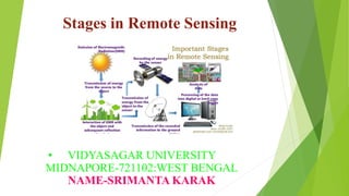
- 2. The process of remote sensing involves a number of processes starting from energy emission from source to data analysis and information extraction. The stages of remote sensing are described in follows steps: INTRODUCTION
- 3. The source of energy (electromagnetic radiations) is a prerequisite for the process of remote sensing. The energy sources may be indirect (e.g. the sun) or direct (e.g. radar). The indirect sources vary with time and location, while we have control over direct sources. These sources emit electromagnetic radiations (EMRs) in the wavelength regions, which can be sensed by the sensors. 1.0)Source of Energy:-
- 4. The EMR interacts with the atmosphere while traveling from the source to earth features and from earth features to the sensor. During this whole path the EMR changes its properties due to loss of energy and alteration in wavelength, which ultimately affects the sensing of the EMR by the sensor. This interaction often leads to atmospheric noise (it will be discussed in separate topic). 2.0)Interaction of EMR with the Atmosphere:-
- 5. The incident EMR on the earth features interacts in various ways. It get reflected, absorbed, transmitted & emitted by the features and ground objects. The amount of EMR reflected, absorbed, transmitted and emitted depends upon the properties of the material in contact and EMR itself. 3.0)EMR Interaction with Earth Features:-
- 6. The remote sensing device records the EMR coming to the sensor after its interaction with the earth features. The kind of EMR which can be sensed by the device depends upon the amount of EMR and sensor’s capabilities. 4.0)Detection of EMR by the remote sensing sensor:-
- 7. The EMR recorded by the remote sensing device is transmitted to earth receiving and data processing stations. Here the EMR are transformed into interpretable output- digital or analogue images. 5.0)Data Transmission and Processing:-
- 8. The digital satellite images are processed using specialized software meant for satellite image processing. The image processing and further analysis of satellite data leads to information extraction, which is required by the users. 6.0)Image Processing and Analysis:-
- 9. The extracted information is utilized to make decisions for solving particular problems. Thus remote sensing is a multi-disciplinary science, which includes a combination of various disciplines such as optics, photography, computer, electronics, telecommunication and satellite-launching etc. 7.0)Application:-
- 10. STAGES OF REMOTE SENSING
- 11. THANK YOU