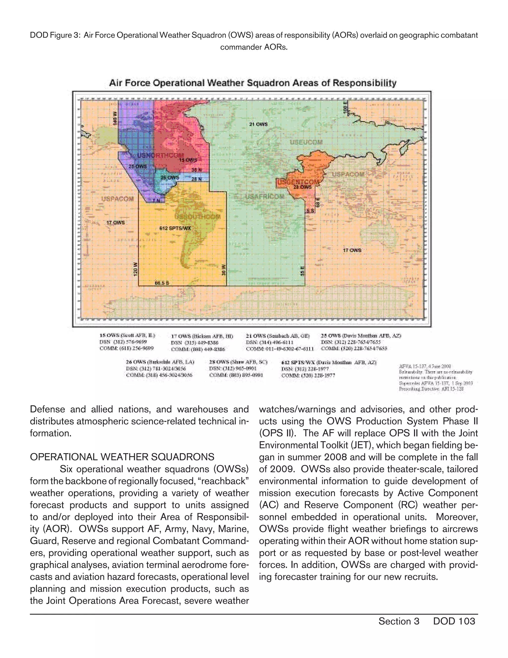
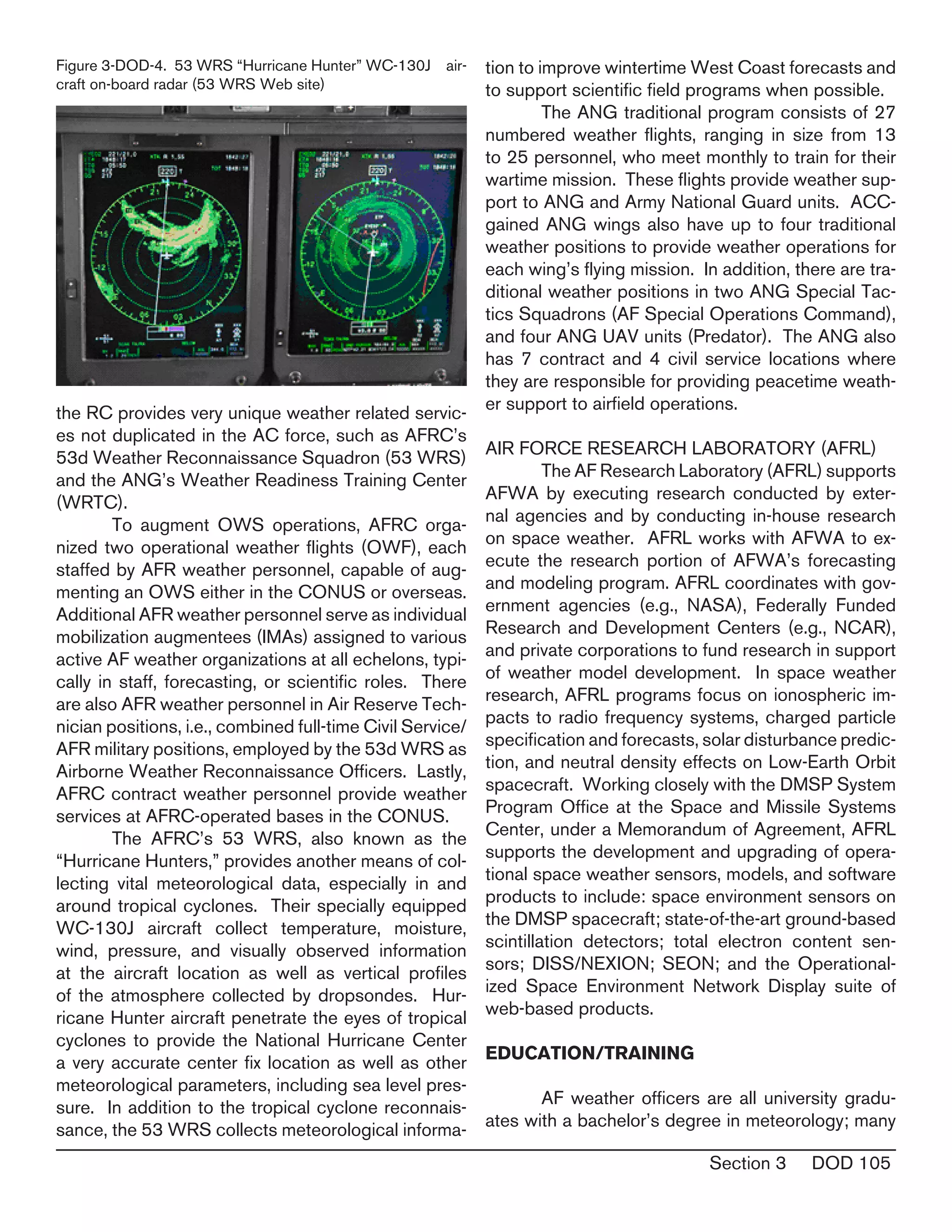
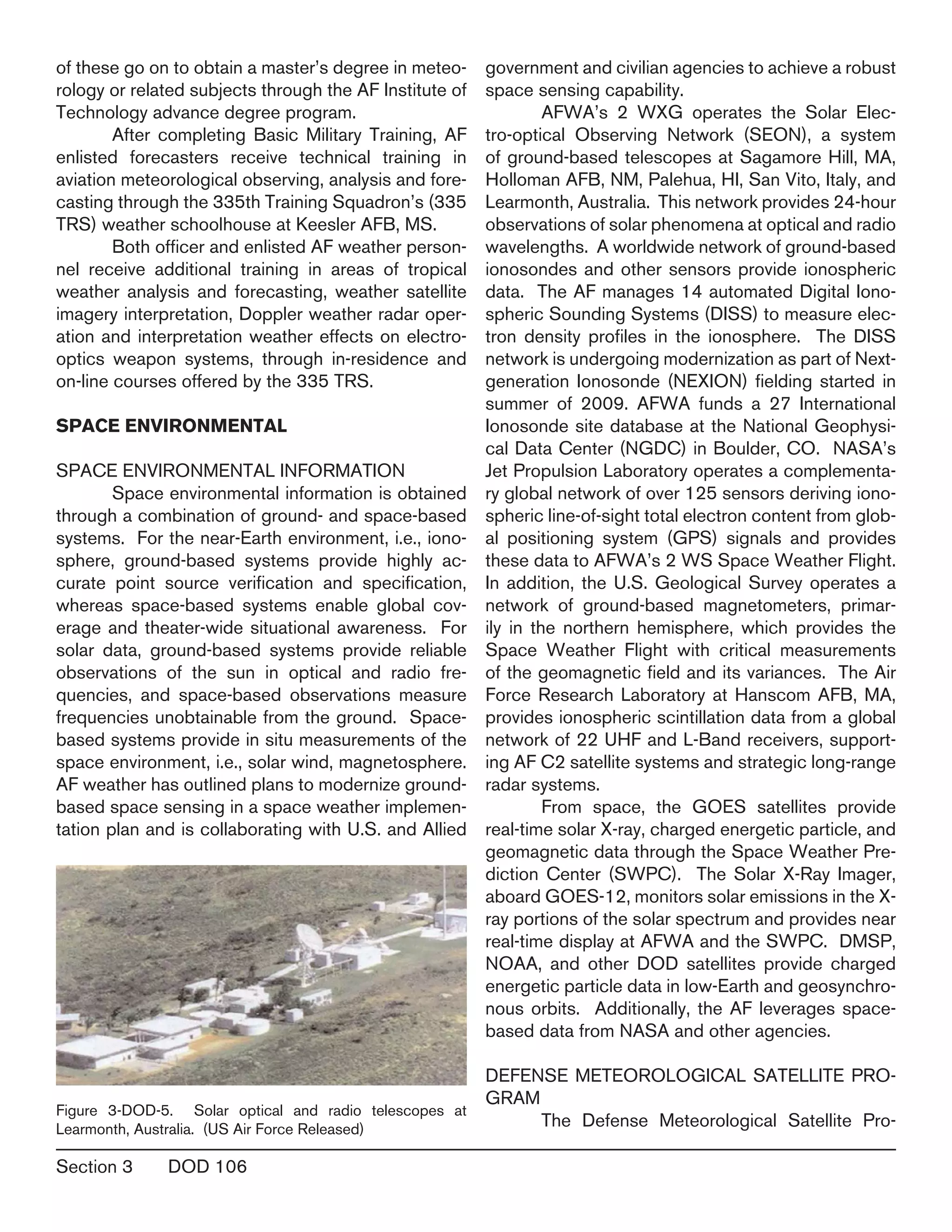
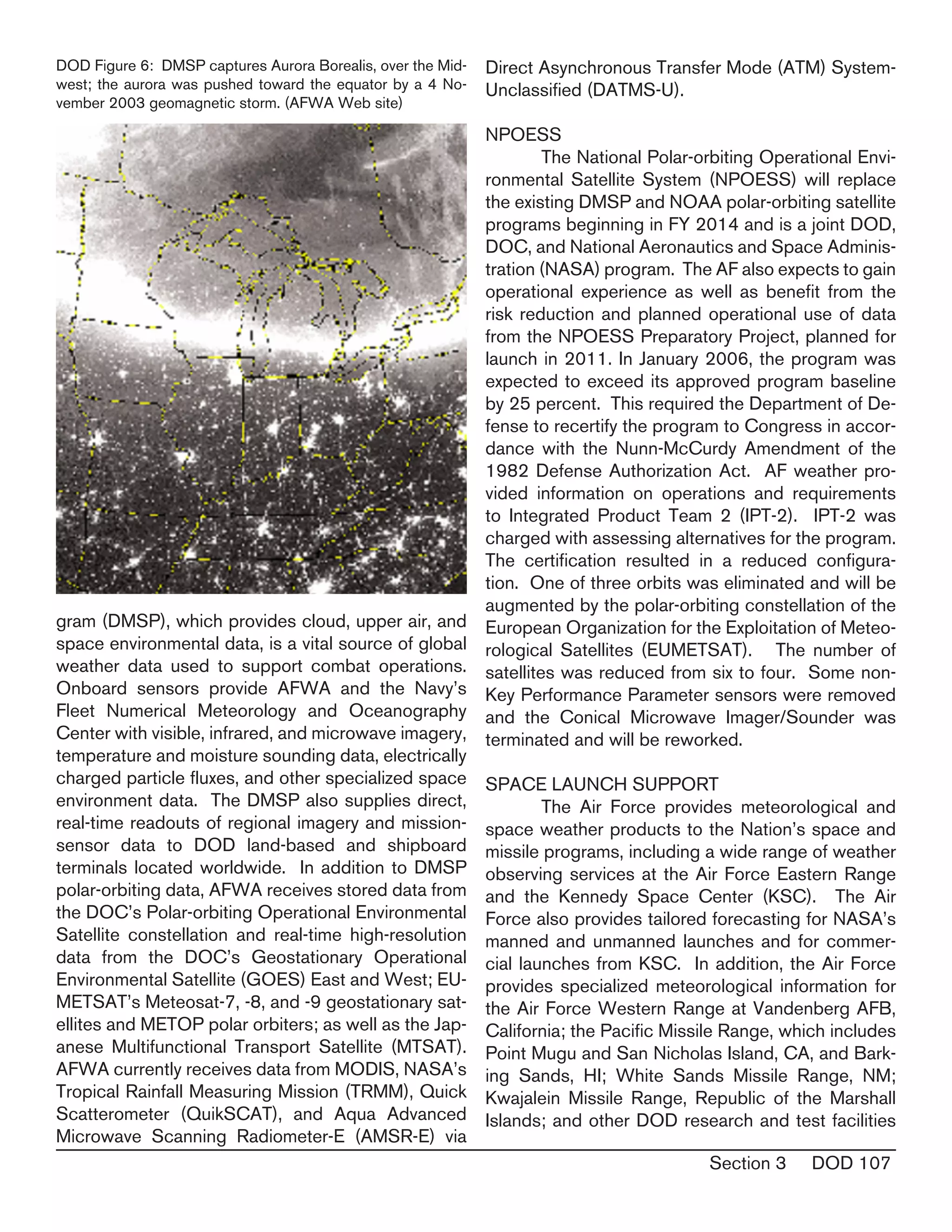
SlideShare a Scribd company logo
1 of 38
Download to read offline
Section 3 DOD 101
Management of weather officer, enlisted, and ci-•	
vilian career fields
Development and implementation of mid- to•	
long-range plans for the organization, equipment,
manpower, and technology necessary to meet
future Air Force, Army, Special Forces, and other
DOD agency weather requirements
Advising Air Staff and subordinate headquarters•	
weather functional managers regarding manpow-
er, career field management, personnel utiliza-
tion, training, operations policy and procedures,
and technology acquisition
Advocating and fielding standardized weather•	
Figure 3-DOD-1: Air Force Weather Mission Statement
USAF METEOROLOGICAL AND SPACE ENVI-
RONMENTAL SERVICES
OVERVIEW
	 Air Force weather forces provide high-quality,
mission-tailored terrestrial and space environment
observations, forecasts, and services to the U.S.
Air Force (USAF), U.S. Army (USA), and a variety
of U.S. Government (USG) departments and agen-
cies. Air Force weather enables Joint Warfighters
to anticipate and exploit the weather...for air, space,
cyberspace, and ground operations
ORGANIZATION
	 AF weather is functionally organized under
the Director of Weather (AF/A3O-W), Director-
ate of Operations (AF/A3O), Deputy Chief of Staff,
Operations, Plans, and Requirements (AF/A3/A5),
Headquarters Air Force. The Director of Weather
oversees Air Force-wide training, organizing, and
equipping of AF weather organizations to include the
following functions:
Development of doctrine, policies, requirements,•	
and standards for weather support for worldwide
AF, Army, and Special Forces training and com-
bat operations
Evaluation of weather support effectiveness for•	
worldwide training and combat operations
UNITED STATES AIR FORCE
DEPARTMENT OF DEFENSE WEATHER PROGRAMS
The Department of Defense (DOD) operates military environmental services
to provide specialized worldwide meteorological, space environmental and
oceanographic analysis, and prediction services in support of military forces and
joint operations. Military environmental services directly support all phases of
military operations from strategic planning to tactical operations. While the Army
and Marine Corps each have small weather operations capabilities, the Navy
and Air Force are the primary sources of military weather products and services.
The military weather services contribute to the national and international weather
observing capability by taking conventional observations on land and at sea
where there are no other conventional weather observing capabilities and where the observations are most
needed to meet military requirements. In addition, DOD maintains specialized observing capabilities, such
as the Defense Meteorological Satellite Program to meet unique military requirements. Observational data
are sent through military communications systems to military and civil facilities in the United States and
overseas.
Section 3	 DOD 102
equipment to support worldwide training and
combat operations
	 AF weather operations provide a Total Force
capability employing over 4,100 Active Duty (AD) and
Reserve Component (RC) military and civilian per-
sonnel supporting Air Force and Army conventional
and Special Operations Forces (SOF) worldwide.
The majority of AF weather personnel are focused
on two distinct, yet related functions: characterizing
the past, current, and future state of the natural envi-
ronment, and exploiting environmental information to
provide actionable environmental impacts informa-
tion directly to decision-makers.
	 AF weather is organized in a 3-tier structure
to maximize capabilities that can be accomplished in
the rear area via “reachback” technology. This mini-
mizes forward presence on the battlefield, making a
“light and lean” presence consistent with the overall
USAF vision for contingency operations in the 21st
century.
AIR FORCE WEATHER AGENCY (AFWA)
	 The centerpiece of global-scale collection
and production is the Air Force Weather Agency
(AFWA), Offutt AFB, NE, a field operating agency
reporting directly to the Air Force Director of Weath-
er. AFWA performs two distinct functions for AF
weather. As part of its Lead Command responsi-
bilities, AFWA plans, programs, and fields standard
weather systems. At the same time, AFWA has a
strategic-level operations and production function.
Specifically, AFWA is charged with collecting, ana-
lyzing, predicting, tailoring, and integrating weather
data at all operational levels.
	 Through the execution of the second func-
tion, AFWA provides timely, accurate, relevant, and
consistent terrestrial and space weather products
necessary to effectively plan and conduct military
operations at all levels of war. AFWA operates a
satellite data processing center and a centralized cli-
matology center with the largest military archive of
meteorological data in the world. The agency runs
numerical weather prediction models, conducts glob-
al cloud and snow analyses, and runs cloud analysis
and forecast models. AFWA also maintains a global
meteorological database, and provides dedicated
support to the Intelligence Community (IC).
	 AFWA consists of a functional management
headquarters; the 1st Weather Group (1 WXG)
with three subordinate CONUS operational weath-
er squadrons (OWS); the 2nd Weather Group (2
WXG), which operates three squadrons, two at Of-
futt and one at Asheville, NC; the Air Force Combat
Weather Center at Hurlburt Field, FL, which sup-
ports the Combat Weather Flights and Battlefield
Weather Teams through investigation, development,
integration, exploitation, and training across new
and existing systems and processes; as well as five
detachments and operating locations. The 1 WXG
commands three operational weather squadrons
that conduct weather operations in support of Total
Force Army and Air Force operations in the CONUS:
the 15th Operational Weather Squadron (15 OWS)
at Scott AFB, IL, the 26th Operational Squadron (26
OWS) at Barksdale AFB, LA, and the 25th Opera-
tional Weather Squadron (25 OWS) at Davis-Mon-
than AFB, AZ.
	 The 2 WXG, collocated with HQ AFWA at
Offutt AFB, NE, consists of the 2nd Systems Op-
erations Squadron (2 SYOS) which provides auto-
mated weather characterization on a global scale,
the 2nd Weather Squadron (2 WS) which provides
global coverage of forecaster-in-the-loop products
to exploit the weather as well a backup for two na-
tional weather centers (Space Weather Prediction
Center and the Washington-Volcanic Ash Advisory
Center), and the 14th Weather Squadron (14 WS)
at Asheville, NC, which provides centralized clima-
tological database services, produces specialized
weather-impact information for the Department of
Figure 3-DOD-2. AF Weather Agency’s “Lt Gen Thomas S
Moorman” Building, opened April, 2008.
Section 3 DOD 103
Defense and allied nations, and warehouses and
distributes atmospheric science-related technical in-
formation.
OPERATIONAL WEATHER SQUADRONS
	 Six operational weather squadrons (OWSs)
form the backbone of regionally focused, “reachback”
weather operations, providing a variety of weather
forecast products and support to units assigned
to and/or deployed into their Area of Responsibil-
ity (AOR). OWSs support AF, Army, Navy, Marine,
Guard, Reserve and regional Combatant Command-
ers, providing operational weather support, such as
graphical analyses, aviation terminal aerodrome fore-
casts and aviation hazard forecasts, operational level
planning and mission execution products, such as
the Joint Operations Area Forecast, severe weather
watches/warnings and advisories, and other prod-
ucts using the OWS Production System Phase II
(OPS II). The AF will replace OPS II with the Joint
Environmental Toolkit (JET), which began fielding be-
gan in summer 2008 and will be complete in the fall
of 2009. OWSs also provide theater-scale, tailored
environmental information to guide development of
mission execution forecasts by Active Component
(AC) and Reserve Component (RC) weather per-
sonnel embedded in operational units. Moreover,
OWSs provide flight weather briefings to aircrews
operating within their AOR without home station sup-
port or as requested by base or post-level weather
forces. In addition, OWSs are charged with provid-
ing forecaster training for our new recruits.
DOD Figure 3: Air Force Operational Weather Squadron (OWS) areas of responsibility (AORs) overlaid on geographic combatant
commander AORs.
Section 3	 DOD 104
WEATHER FLIGHT/DETACHMENTS
	 At AF bases and Army posts, AF weather forc-
es focus on their warfighter’s mission requirements.
These units provide and disseminate observations
and develop tailored mission execution forecasts
based on centrally produced guidance. Personnel
in these units also act as “eyes forward” for their
supporting OWS. Weather personnel supporting
conventional AF operations typically deploy with a
New Tactical Forecast System (N-TFS), (currently
being upgraded to the Joint Environmental Toolkit),
the TMQ-53 tactical observing system for semi-per-
manent sites, and hand-held Kestrel observing kits
for back-up operations. This equipment, coupled
with robust communications to receive weather data
including satellite imagery, provides the essential ca-
pability required for deployed weather forces to meet
operational requirements. Currently, AF weather has
130+ weather organizations supporting USAF or
US Army units at the wing, corps, division, or brigade
level, and leverage communications “reachback” to
OWSs & to AFWA.
	 For AF operations, these weather profes-
sionals are normally assigned to a flight under an
operations support squadron in an AF flying wing;
however, individuals from the weather flight are in-
tegrated into flying squadron mission planning and
execution processes. In this capacity, they infuse
critical weather information at key points in the deci-
sion cycle to help aircrews maximize wartime capa-
bilities, enhance flight safety, and optimize training
effectiveness. Weather experts are also assigned to
weather specialty teams in air and space operations
centers. This cross-cutting team integrates environ-
mental information at key decision points of air and
space operations planning, execution, and assess-
ment. Armed with this information, decision-makers
can balance operational risks against mission need
to optimize timing, tactics, target and weapons se-
lection, and other factors affecting air and space op-
erations.
	 Likewise, Army weather requirements are in-
corporated into the AF’s overall weather operations
concept. AF weather forces are integrated with Army
intelligence staffs. The Army trains and educates Air
Force personnel on Army organizations, concepts of
operations, and the weather sensitivities. AF weather
forces are currently habitually aligned with echelons
above corps, corps, divisions, separate brigades,
aviation brigades, armored cavalry regiments, ranger
regiments, and Special Forces groups (as well as
subordinate battalions deployed at forward operat-
ing bases). Over the next few years, AF weather
support to the Army will undergo significant trans-
formation as the Army transitions from a division-
centric force based on large standing organizations
to a brigade-centric force based on smaller, modular
organizations.
OPERATION IRAQI FREEDOM/OPERATION EN-
DURING (OIF/OEF) FREEDOM SUPPORT
	 AF weather units are fully engaged in contin-
gency operations in Iraq and Afghanistan, and play
an integral part in support of OIF/OEF AF and Army
missions and operations. Currently, 198 AF weath-
er personnel are deployed to 33 locations around
the world. The success of reachback communica-
tions and support between AFWA/OWSs and for-
ward deployed weather units has decreased the
AF weather forward “footprint” 40% since DESERT
STORM, despite a much higher operations tempo
at these locations. In terms of customers supported,
about 50% of AF weather deployed personnel are
supporting AF operations, 40% are supporting US
Army operations, and 10% are supporting Special
Operations Forces operations.
	 As an example of its focus on the OIF/OEF
missions, AF weather has procured “Weather Pod”
observing systems that are being fielded as remote
expendable observing systems in support of AF and
Army operations in the OEF/OIF theaters. They will
be used to take observations at locations where AF
weather personnel are deployed as well as at loca-
tions where there are typically no weather person-
nel, such as forward operating bases and forward
air refueling ports. The Weather Pods may also be
placed along select flight routes and other locations
of particular weather interest.
RESERVE COMPONENT
	 The Reserve Component (RC) is composed
of the Air Force Reserve Command (AFRC) and the
Air National Guard (ANG). AF weather continues to
integrate these forces to more closely align with AC
weather force operations. Air Force RC weather per-
sonnel augment the AC at all levels. In some cases,
Section 3 DOD 105
the RC provides very unique weather related servic-
es not duplicated in the AC force, such as AFRC’s
53d Weather Reconnaissance Squadron (53 WRS)
and the ANG’s Weather Readiness Training Center
(WRTC).
	 To augment OWS operations, AFRC orga-
nized two operational weather flights (OWF), each
staffed by AFR weather personnel, capable of aug-
menting an OWS either in the CONUS or overseas.
Additional AFR weather personnel serve as individual
mobilization augmentees (IMAs) assigned to various
active AF weather organizations at all echelons, typi-
cally in staff, forecasting, or scientific roles. There
are also AFR weather personnel in Air Reserve Tech-
nician positions, i.e., combined full-time Civil Service/
AFR military positions, employed by the 53d WRS as
Airborne Weather Reconnaissance Officers. Lastly,
AFRC contract weather personnel provide weather
services at AFRC-operated bases in the CONUS.
	 The AFRC’s 53 WRS, also known as the
“Hurricane Hunters,” provides another means of col-
lecting vital meteorological data, especially in and
around tropical cyclones. Their specially equipped
WC-130J aircraft collect temperature, moisture,
wind, pressure, and visually observed information
at the aircraft location as well as vertical profiles
of the atmosphere collected by dropsondes. Hur-
ricane Hunter aircraft penetrate the eyes of tropical
cyclones to provide the National Hurricane Center
a very accurate center fix location as well as other
meteorological parameters, including sea level pres-
sure. In addition to the tropical cyclone reconnais-
sance, the 53 WRS collects meteorological informa-
tion to improve wintertime West Coast forecasts and
to support scientific field programs when possible.
	 The ANG traditional program consists of 27
numbered weather flights, ranging in size from 13
to 25 personnel, who meet monthly to train for their
wartime mission. These flights provide weather sup-
port to ANG and Army National Guard units. ACC-
gained ANG wings also have up to four traditional
weather positions to provide weather operations for
each wing’s flying mission. In addition, there are tra-
ditional weather positions in two ANG Special Tac-
tics Squadrons (AF Special Operations Command),
and four ANG UAV units (Predator). The ANG also
has 7 contract and 4 civil service locations where
they are responsible for providing peacetime weath-
er support to airfield operations.
AIR FORCE RESEARCH LABORATORY (AFRL)
	 The AF Research Laboratory (AFRL) supports
AFWA by executing research conducted by exter-
nal agencies and by conducting in-house research
on space weather. AFRL works with AFWA to ex-
ecute the research portion of AFWA’s forecasting
and modeling program. AFRL coordinates with gov-
ernment agencies (e.g., NASA), Federally Funded
Research and Development Centers (e.g., NCAR),
and private corporations to fund research in support
of weather model development. In space weather
research, AFRL programs focus on ionospheric im-
pacts to radio frequency systems, charged particle
specification and forecasts, solar disturbance predic-
tion, and neutral density effects on Low-Earth Orbit
spacecraft. Working closely with the DMSP System
Program Office at the Space and Missile Systems
Center, under a Memorandum of Agreement, AFRL
supports the development and upgrading of opera-
tional space weather sensors, models, and software
products to include: space environment sensors on
the DMSP spacecraft; state-of-the-art ground-based
scintillation detectors; total electron content sen-
sors; DISS/NEXION; SEON; and the Operational-
ized Space Environment Network Display suite of
web-based products.
EDUCATION/TRAINING
	 AF weather officers are all university gradu-
ates with a bachelor’s degree in meteorology; many
Figure 3-DOD-4. 53 WRS “Hurricane Hunter” WC-130J air-
craft on-board radar (53 WRS Web site)
Section 3	 DOD 106
of these go on to obtain a master’s degree in meteo-
rology or related subjects through the AF Institute of
Technology advance degree program.
	 After completing Basic Military Training, AF
enlisted forecasters receive technical training in
aviation meteorological observing, analysis and fore-
casting through the 335th Training Squadron’s (335
TRS) weather schoolhouse at Keesler AFB, MS.
	 Both officer and enlisted AF weather person-
nel receive additional training in areas of tropical
weather analysis and forecasting, weather satellite
imagery interpretation, Doppler weather radar oper-
ation and interpretation weather effects on electro-
optics weapon systems, through in-residence and
on-line courses offered by the 335 TRS.		
SPACE ENVIRONMENTAL
SPACE ENVIRONMENTAL INFORMATION
	 Space environmental information is obtained
through a combination of ground- and space-based
systems. For the near-Earth environment, i.e., iono-
sphere, ground-based systems provide highly ac-
curate point source verification and specification,
whereas space-based systems enable global cov-
erage and theater-wide situational awareness. For
solar data, ground-based systems provide reliable
observations of the sun in optical and radio fre-
quencies, and space-based observations measure
frequencies unobtainable from the ground. Space-
based systems provide in situ measurements of the
space environment, i.e., solar wind, magnetosphere.
AF weather has outlined plans to modernize ground-
based space sensing in a space weather implemen-
tation plan and is collaborating with U.S. and Allied
government and civilian agencies to achieve a robust
space sensing capability.
	 AFWA’s 2 WXG operates the Solar Elec-
tro-optical Observing Network (SEON), a system
of ground-based telescopes at Sagamore Hill, MA,
Holloman AFB, NM, Palehua, HI, San Vito, Italy, and
Learmonth, Australia. This network provides 24-hour
observations of solar phenomena at optical and radio
wavelengths. A worldwide network of ground-based
ionosondes and other sensors provide ionospheric
data. The AF manages 14 automated Digital Iono-
spheric Sounding Systems (DISS) to measure elec-
tron density profiles in the ionosphere. The DISS
network is undergoing modernization as part of Next-
generation Ionosonde (NEXION) fielding started in
summer of 2009. AFWA funds a 27 International
Ionosonde site database at the National Geophysi-
cal Data Center (NGDC) in Boulder, CO. NASA’s
Jet Propulsion Laboratory operates a complementa-
ry global network of over 125 sensors deriving iono-
spheric line-of-sight total electron content from glob-
al positioning system (GPS) signals and provides
these data to AFWA’s 2 WS Space Weather Flight.
In addition, the U.S. Geological Survey operates a
network of ground-based magnetometers, primar-
ily in the northern hemisphere, which provides the
Space Weather Flight with critical measurements
of the geomagnetic field and its variances. The Air
Force Research Laboratory at Hanscom AFB, MA,
provides ionospheric scintillation data from a global
network of 22 UHF and L-Band receivers, support-
ing AF C2 satellite systems and strategic long-range
radar systems.
	 From space, the GOES satellites provide
real-time solar X-ray, charged energetic particle, and
geomagnetic data through the Space Weather Pre-
diction Center (SWPC). The Solar X-Ray Imager,
aboard GOES-12, monitors solar emissions in the X-
ray portions of the solar spectrum and provides near
real-time display at AFWA and the SWPC. DMSP,
NOAA, and other DOD satellites provide charged
energetic particle data in low-Earth and geosynchro-
nous orbits. Additionally, the AF leverages space-
based data from NASA and other agencies.
	
DEFENSE METEOROLOGICAL SATELLITE PRO-
GRAM
	 The Defense Meteorological Satellite Pro-
Figure 3-DOD-5. Solar optical and radio telescopes at
Learmonth, Australia. (US Air Force Released)
Section 3 DOD 107
gram (DMSP), which provides cloud, upper air, and
space environmental data, is a vital source of global
weather data used to support combat operations.
Onboard sensors provide AFWA and the Navy’s
Fleet Numerical Meteorology and Oceanography
Center with visible, infrared, and microwave imagery,
temperature and moisture sounding data, electrically
charged particle fluxes, and other specialized space
environment data. The DMSP also supplies direct,
real-time readouts of regional imagery and mission-
sensor data to DOD land-based and shipboard
terminals located worldwide. In addition to DMSP
polar-orbiting data, AFWA receives stored data from
the DOC’s Polar-orbiting Operational Environmental
Satellite constellation and real-time high-resolution
data from the DOC’s Geostationary Operational
Environmental Satellite (GOES) East and West; EU-
METSAT’s Meteosat-7, -8, and -9 geostationary sat-
ellites and METOP polar orbiters; as well as the Jap-
anese Multifunctional Transport Satellite (MTSAT).
AFWA currently receives data from MODIS, NASA’s
Tropical Rainfall Measuring Mission (TRMM), Quick
Scatterometer (QuikSCAT), and Aqua Advanced
Microwave Scanning Radiometer-E (AMSR-E) via
Direct Asynchronous Transfer Mode (ATM) System-
Unclassified (DATMS-U).
NPOESS
	 The National Polar-orbiting Operational Envi-
ronmental Satellite System (NPOESS) will replace
the existing DMSP and NOAA polar-orbiting satellite
programs beginning in FY 2014 and is a joint DOD,
DOC, and National Aeronautics and Space Adminis-
tration (NASA) program. The AF also expects to gain
operational experience as well as benefit from the
risk reduction and planned operational use of data
from the NPOESS Preparatory Project, planned for
launch in 2011. In January 2006, the program was
expected to exceed its approved program baseline
by 25 percent. This required the Department of De-
fense to recertify the program to Congress in accor-
dance with the Nunn-McCurdy Amendment of the
1982 Defense Authorization Act. AF weather pro-
vided information on operations and requirements
to Integrated Product Team 2 (IPT-2). IPT-2 was
charged with assessing alternatives for the program.
The certification resulted in a reduced configura-
tion. One of three orbits was eliminated and will be
augmented by the polar-orbiting constellation of the
European Organization for the Exploitation of Meteo-
rological Satellites (EUMETSAT). The number of
satellites was reduced from six to four. Some non-
Key Performance Parameter sensors were removed
and the Conical Microwave Imager/Sounder was
terminated and will be reworked.
SPACE LAUNCH SUPPORT
	 The Air Force provides meteorological and
space weather products to the Nation’s space and
missile programs, including a wide range of weather
observing services at the Air Force Eastern Range
and the Kennedy Space Center (KSC). The Air
Force also provides tailored forecasting for NASA’s
manned and unmanned launches and for commer-
cial launches from KSC. In addition, the Air Force
provides specialized meteorological information for
the Air Force Western Range at Vandenberg AFB,
California; the Pacific Missile Range, which includes
Point Mugu and San Nicholas Island, CA, and Bark-
ing Sands, HI; White Sands Missile Range, NM;
Kwajalein Missile Range, Republic of the Marshall
Islands; and other DOD research and test facilities
DOD Figure 6: DMSP captures Aurora Borealis, over the Mid-
west; the aurora was pushed toward the equator by a 4 No-
vember 2003 geomagnetic storm. (AFWA Web site)
Section 3	 DOD 108
as directed.
AIR AND SPACE NATURAL ENVIRONMENT
MODELING AND SIMULATION
	 The Air Force Director of Weather carries out
the DOD Air and Space Natural Environment Model-
ing and Simulation Executive Agent (ASNE MSEA)
responsibilities of managing, coordinating, and im-
plementing all aspects of modeling and simulation
relating to the Air and Space Natural Environment
domain to include, but not limited to, planning, pro-
gramming, monitoring, and reporting across all DOD
components in accordance with the Under Secretary
of Defense for Acquisition, Technology, and Logis-
tics Memorandum to the Secretary of the Air Force,
designating the Department of the Air Force as the
MSEA for air and space natural environment repre-
sentations. The DOD ASNE MSEA ensures DOD
communities who use simulations for their training,
acquisition, testing, planning, experimentation, and
analysis have the right tools, infrastructure, and da-
tabases necessary to represent the air and space
natural environment and its effects.
RESEARCH INITIATIVES
	 The overarching objective of the Air Force
meteorological and space environmental technol-
ogy transition program is to provide capability de-
signers, operational weather personnel, and weather
information users the technology and tools to gain
and maintain the advantage over a potential adver-
sary. Air Force weather’s capability needs in the at-
mospheric and space environment sciences are ar-
ticulated in the Meteorological and Oceanographic
(METOC) Environment and the Ionospheric Effects
Characterization (IEC) Initial Capabilities Docu-
ments (ICDs), Capability Review assessments, the
AFW and AFWA Strategic Plans, the AFW Opera-
tions Functional Concept and Enabling Concepts
(Characterize the Environment, Exploit Environmen-
tal Information, and Net-Centric Operations), and
supporting concept and implementation plans. AF
weather also strives toward improvements through
cooperative development and testing agreements
both with other governmental agencies and labora-
tories, as well as for-profit companies. Additionally,
both AFIT and the Naval Postgraduate School offer
AF graduate students in the atmospheric and space
environmental sciences an opportunity to research
topics of immediate operational interest to the Ser-
vice.
CLOUD FORECASTING
	 In applied meteorological R&D, the AF is im-
proving cloud forecasting techniques by doubling
the resolution, using a new cloud interpretation/typ-
ing scheme, and blending numerical weather predic-
tion with forecast cloud advection techniques. The
AF has transitioned key advances in tactical decision
aids into operations, permitting improved forecasting
of electro-optical system performance and genera-
tion of cloud and target scene visualizations for train-
ing, system development, and mission rehearsal.
weather forecast Modeling for Af and
Army Operations
	 The Weather Research and Forecasting
(WRF) model is the next generation community
model and is another area of AFWA participation
in research and development in collaboration with
NCAR, NOAA’s NCEP, NOAA’ s Earth Systems
Research Laboratory (ESRL), the University of Okla-
homa’s Center for the Analysis and Prediction of
Storms, and others. AFWA initially implemented
WRF operationally in 2006 and will continue with
sponsorship and funding of development at NCAR
and ESRL, test and evaluation of real-time runs of
the WRF prototype. The Land Information System
(LIS) analyzes the current state of the land surface
to provide information to DOD and civilian agencies,
and through coupling with WRF, will improve fore-
casting performance in the low levels of the atmo-
sphere. This allows AF weather forces to provide
better forecasts for low-level aircraft operations, the
dispersion of aerosol contaminants, and the employ-
ment of precision-guided munitions. It also allows
for assessment of trafficability for ground forces.
	 AFWA is in the process of identifying a fu-
ture capability called the Ensemble Prediction Sys-
tem (EPS). EPS output will help AF Weather per-
sonnel to provide better forecasts for the warfighter
with increased confidence, particularly at the tactical
level. The ongoing Joint Ensemble Forecast System
(JEFS) prototype effort is laying the groundwork to
Section 3 DOD 109
construct an operational EPS and the first non-op-
erational JEFS products are being produced daily at
AFWA as part of the JEFS test in the U.S. Pacific
Command (USPACOM) and U.S. Central Command
(USCENTCOM) AORs.
TACTICAL DECISION AIDS
	 AF weather collaborates in the development
of several tactical decision aids, to include the Target
Acquisition Weapons Software (TAWS), the Infrared
Target Scene Simulator (IRTSS), and Tri-Service In-
tegrated Weather Effects Decision Aid (T-IWEDA).
	 TAWS provides a joint mission-planning tool
to combine platform, weapon, target, background,
and weather impacts to depict three-dimensional
target acquisition and lock-on range and recogni-
tion range versus time. This includes prediction of
environmental impacts on night vision goggles and
low light-level systems used by air, naval, and ground
forces to execute nighttime operations. IRTSS uses
detailed terrain information and multi-spectral imag-
ery with TAWS weather inputs to generate forecast
target scene images for mission rehearsal.
	 The Air Force Research Laboratory (AFRL),
the Navy’s Space and Naval Warfare Systems Com-
mand, the Navy Research Laboratory (NRL), and
the Army Research Laboratory (ARL) are develop-
ing modular programs as part of the Tri-Service In-
tegrated Weather Effects Decision Aid (T-IWED+A)
initiative. The T-IWEDA uses environmental data
with force, mission, and/or individual weapons rules
of engagement or performance parameters to au-
tomatically generate mission-impact forecasts for
large-scale planning efforts such as air tasking order
preparation.
	 TAWS, IRTSS, and T-IWEDA integrate envi-
ronmental impacts into the mission execution fore-
casts for C2 and mission planning (MP) systems
throughout the military planning and execution cycle.
The TDA program continues adding weapons sys-
tems and targets at the request of users from the
Services.	
RESEARCH PARTNERING INITIATIVES
	 AF weather is partnering with the NWS and
the Navy in the National Unified Operational Pre-
diction Capability (NUOPC) project. This partner-
ship exists to enable a Tri-Agency joint global at-
mospheric ensemble forecast system. NUOPC is
an integration of ongoing efforts coordinated by a
Tri-agency management organization. The NUOPC
vision is a National NWP system with interoperable
components built on common standards and frame-
work (Earth System Modeling Framework (ESMF))
with managed operational ensemble diversity and a
national global NWP research agenda to accelerate
science and technology infusion.
Section 3	 DOD 110
Section 3 DOD 111
UNITED STATES NAVY
OVERVIEW
	 The U. S. Navy’s Oceanography and
Meteorology Program (NOP) provides global
meteorology, oceanographic, Maritime Geospatial-
Environmental Information & Services and ocean
surveillance critical for safe and effective operations
of the Navy and Marine Corps and the Department
of Defense. Its mission is to protect the Fleet, shape
the battlespace and maximize warfighting capability.
The program includes oceanography, bathymetry,
hydrography, meteorology, acoustics, geophysics,
astrometry, geospatial information and precise time.
	 NavalMETOCunderpinseveryaspectofnaval
operations and warfare. It provides an affordable and
sustainable competitive advantage to the Nation and
protects the substantial National investment in both
afloat and ashore force structure.
	 The NOP, which is supported by ocean
engineering, operational supercomputing and
operations research, in recent years reinvented itself
to meet the warfighting needs of the operators and
the fiscal needs of today’s Navy.
	 Increasingly, costs are leveraged in the
Joint, interagency and international arenas to deliver
capabilities at a shared cost. The NOP is the
Department of Defense’s global Numerical Weather
Forecasting Capability and it partners with Air Force
weather in the areas of flight weather forecasting,
Joint operations, information management and
acquisition programs. It also has strong relationships
with all five directorates in NOAA.
ORGANIZATION
OCEANOGRAPHER OF THE NAVY
	 The Oceanographer of the Navy (OPNAV
N84) represents the Naval Oceanography Program
on the staff of the Chief of Naval Operations. His
staff works closely with the staff of Commander
Naval Meteorology and Oceanography Command
(CNMOC), the operational arm of the Naval
Oceanography Program, to ensure the proper
resourcesareavailabletomeetmissionrequirements,
to act as a liaison between CNMOC and the
Chief of Naval Operations, and to represent the
Naval Oceanography Program in interagency and
international forums.
	 In April 2009, the Oceanographer of the
Navy and Commander, Naval Meteorology and
Figure 3-DOD-7. USS Annapolis (USN 760) is seen on the surface of the Arctic Ocean after breaking through three feet of ice
during ICEX 2009 (U.S. Navy photo)
Section 3	 DOD 112
Oceanography Command signed into effect Naval
Oceanography 2025, a strategic vision of the future
of the Naval Oceanography Program. Incorporating
inputs and perspectives from a wide array of
stakeholders, this document will be used to guide
investmentsinresearchanddevelopment,acquisition,
work force structure, and future operational concepts
based on realistic expectations of future changes,
and community-wide support.
	 In May 2009, the Chief of Naval Operations
appointed the Oceanographer of the Navy to head
Task Force Climate Change (TFCC). TFCC will
address the emerging Navy need to develop a
comprehensive approach about the Arctic to guide
its future public, policy, and strategy discussions.
TFCC will recommend policy, strategy, roadmaps,
and investments for the Navy regarding the Arctic
and Climate Change that are consistent with existing
National,Joint,andNavalguidance,includingNational
Security Presidential Directive/ Homeland Security
Presidential Directive (NSPD-66/HSPD-25), Joint
Vision 2020, Sea Power 21, and a Cooperative
Strategy for 21st Century Seapower. The initial
focus for TFCC will be the Arctic, and the primary
deliverable will be a holistic, chronological science-
based roadmap for future Navy action with respect
to the Arctic between now and 2040.
	 In addition, Navy weather is partnering with
the NWS and the Air Force in the National Unified
Operational Prediction Capability (NUOPC) project.
This partnership exists to enable a Tri-Agency
joint global atmospheric ensemble forecast
system. NUOPC is an integration of ongoing
efforts coordinated by a Tri-agency management
organization. The NUOPC vision is a National NWP
system with interoperable components built on
common standards and framework (Earth System
Modeling Framework (ESMF)) with managed
operational ensemble diversity and a national global
NWP research agenda to accelerate science and
technology infusion.
NAVAL METEOROLOGY AND OCEANOGRAPHY
COMMAND
Figure 3-DOD-8. Aerographer’s Mate 2nd Class Derron Gee, from East Hampton, N.Y., runs a satellite loop computer program
used to predict weather patterns in the metrological shop aboard the aircraft carrier USS John C. Stennis (CVN 74). (U.S. Navy
photo by Mass Communication Specialist 3rd Class Kenneth Abbate)
Section 3 DOD 113
	 The Naval Meteorology and Oceanography
Command serves as the operational arm of the
Naval Oceanography Program. Headquartered at
the Stennis Space Center in Mississippi, CNMOC
is a third echelon command reporting to United
States Fleet Forces (USFF). CNMOC’s claimancy
is globally distributed, with assets located on larger
ships (aircraft carriers, amphibious ships, and
command and control ships), shore facilities at fleet
concentration areas, and larger production centers
in the U.S.
	 CNMOC is focused on protecting the
Fleet from destructive weather and providing
critical environmental knowledge to the warfighting
disciplines of Anti-Submarine Warfare; Naval Special
Warfare; Mine Warfare; Intelligence, Surveillance
and Reconnaissance; and Fleet Operations
(Strike and Expeditionary), supported by core
capabilities of Maritime Safety Operations, Aviation
Safety Operations, Navigation, Precise Time, and
Astrometry.
	 Major activities and additional subordinates
within the command currently include:
Naval Oceanography Operations Command,•	
Stennis Space Center, MS
Naval Aviation Forecast Center, Norfolk, VA and•	
detachments
Naval Maritime Forecast Center, Pearl Harbor,•	
HI
Naval Maritime Forecast Center, Norfolk, VA•	
Strike Group Oceanography Teams in Norfolk,•	
VA; San Diego, CA; and Fallon, NV; (with
subordinate mobile environmental teams)
Figure 3-DOD-9. A Navy E-2C Hawkeye approached for an arrested landing on the flight deck of the aircraft carrier USS Harry
S. Truman (CVN 75). The Hawkeye is the Navy’s all-weather, carrier-based tactical battle management airborne early warning,
command and control aircraft. (U.S. Navy photo)
Section 3	 DOD 114
Naval Special Warfare Oceanography Center•	
in San Diego, CA (with components and
detachments in Stuttgart, Germany, Norfolk and
Pearl Harbor)
Naval Oceanography ASW Centers in Yokosuka,•	
Japan and Stennis Space Center, MS (with
subordinate detachments)
Naval Oceanographic Office, Stennis Space•	
Center, MS
Fleet Survey Team, Stennis Space Center MS•	
Naval Ice Center, Suitland, MD•	
Fleet Numerical Meteorology and Oceanography•	
Center, Monterey, CA
U.S. Naval Observatory, Washington, DC•	
Naval Meteorology and Oceanography•	
Professional Development Center, Gulfport, MS
NAVAL OCEANOGRAPHY OPERATIONS
COMMAND (NAVOCEANOPSCOM)
	 The NAVOCEANOPSCOM, headed by the
Commander, Oceanographic Operations, serves as
the principal operational organization of CNMOC
and coordinates and manages efforts among field
activities under the Operational Oceanography
Program to optimize warfighting resources, support
safe operations and enhance dominance of the
battlespace through superior understanding and
exploitation of the environment. The Command
encompasses the nine warfighting and enabling
directorates. Each directorate determines how that
directorate’s services are delivered globally. Each
directorate reports to a single Navy Captain who
functions as Naval Oceanography’s Chief Operating
Officer.
	 The Commander, Oceanographic Operations
supports the combatant commanders and national
missions, U.S. interagency and international partners.
The major NAVMETOCCOM production centers
(NAVOCEANO, FLENUMMETOCEN, NAVOBSY)
support the Commander, Oceanographic
Operations.
	 The command’s operational model is based
on standardizing services for each directorate,
automating everything that can be automated and
coupling situational awareness and a small on-scene
presence, supported by a significant 24/7 reachback
production capability at the major production
centers.
	 Dangerous weather and safe navigation are
the top two Fleet concerns.
Aviation Forecasting
	 Many environmental conditions severely
impactflightoperationsandmissionaccomplishment.
These include: wind speed and direction, cloud
ceiling, precipitation, turbulence, visibility, icing and
severe weather such as thunderstorms. An accurate
forecast is often the deciding factor in mission
success and for the safety of the pilot and their
aircraft.
	 Navy Meteorologists and forecasters analyze
current physical environmental conditions and
use state of the art computer models to forecast
atmospheric and oceanographic phenomena
impacting naval flight operations.
	 Meteorologists are assigned to Aviation
Forecasting hubs in the United States and overseas
locations.
	 Core aviation weather services include
flight route weather briefings via an internet-based
flight weather briefer, severe weather warnings and
advisories for Navy airfields and terminal aerodrome
fore-casts for Navy airfields.
Fleet Operations
	 The Naval Meteorology and Oceanography
Command are actively engaged with Fleet forces to
provide valuable physical environmental knowledge
to aid warfighting decision making. Personnel are
integrated with the Fleet, where they provide in situ
observations, run tactical decision aids and interpret
environmental data to provide decision support to
Fleet commanders.
	 The onboard personnel work with reachback
cellstoanalyzeandforecastenvironmentalconditions
from launch point to target and to determine
optimum Fleet maneuvers, ingress and egress
routes, amphibious landing points and times, flight
operations, weapons load-outs and target selection.
	 Deploying personnel are highly trained
meteorology and oceanography specialists for
support planning and operations. Reachback teams
work with onboard personnel to refine data, develop
models, conduct forecast analyses and deliver high-
quality information to Fleet commands.
	 Tailored Strike Group Oceanography Team
Section 3 DOD 115
(SGOT) Detachments train, work-up and deploy with
carrier and expeditionary strike groups through each
phase of the Fleet Readiness Training Program. Each
SGOT detachment includes a team who forecast for
the aircraft carriers, amphibious assault ships and
other vessels making up the strike group. In addition
to flight deck weather, they forecast en route and
target area METOC conditions which may vary
greatly considering the tremendous reach of Naval
Aviation along the world’s dynamic coastlines.
Maritime Weather Operations
	 Navy meteorologists and forecasters are
assigned to Maritime Forecasting Centers in Hawaii
and Virginia. Core maritime weather services include
Optimum Track Ship Routing (OTSR), a weather
forecasting service to support transoceanic voyages
and coastal operations. OTSR services:
Provide hazardous ocean and weather advisories•	
anddivertrecommendationstoshipCommanding
Officers and Masters at sea.
Include sortie recommendations for potentially•	
damaging weather conditions in port.
Provide preliminary climatologic outlooks for•	
transit and mission planning.
Routine ship weather forecasts (WEAX) and•	
aviation weather forecasts for ship-based
helicopters (AVWX) include high wind and
seas warnings and local area warnings for Fleet
Concentration Areas.
	 The Joint Typhoon Warning Center (JTWC),
established by the U.S. Pacific Command, is jointly
Figure 3-DOD10. Aerographer’s Mate Airman Jonathan
Salgado launches a weather balloon from the fantail of the
aircraft carrier USS Theodore Roosevelt (CVN 71) to gather
atmospheric data. (U.S. Navy Photo by Mass Communication
Specialist Seaman Andrew Skipworth)
Figure 3-DOD-11. Marines from the 22nd Marine Expeditionary
Unit (22 MEU) gather on a port-side weather deck aboard the
amphibious dock landing ship USS Fort McHenry (LSD 43)
to watch as the amphibious assault ship USS Bataan (LHD
5) closes in for a refueling at sea. (U.S. Navy photo by Mass
Communication Specialist 2nd Class Kristopher Wilson)
Section 3	 DOD 116
mannedwithU.S.AirForcepersonnel.JTWCservices
include tropical cyclone forecasts, warnings and
otherproductsforDepartmentofDefensewarfighters
operating in the Pacific and Indian Oceans. JTWC,
located in Pearl Harbor, Hawaii, is an internationally
recognized tropical cyclone forecasting center.
FLEET NUMERICAL METEOROLOGY AND
OCEANOGRAPHY CENTER
	 The Fleet Numerical Meteorology and
Oceanography Center (FLENUMMETOCEN,
FNMOC) an Echelon four activity reporting to the
Commander, Naval Meteorology and Oceanography
Command, is the NOP’s production center for
meteorology. The center plays a significant role
in the National capability for operational weather
and ocean prediction through its operation of
sophisticated global and regional meteorological and
oceanographic models, extending from the top of the
atmosphere to the bottom of the ocean. Through
close collaboration with the Naval Oceanographic
Office (NAVOCEANO), FLENUMMETOCEN is a
key component in the Navy’s operational weather
and ocean prediction program. This program
provides information that helps give Naval forces
an asymmetric advantage in speed, access and
persistence in any combat operation for which they
may be called upon.
	 FLENUMMETOCEN is well known for its long
and productive history of implementing, evaluating,
operating, maintaining and improving complex
Numerical Weather Prediction (NWP) system
specifically to meet the requirements of the U.S. Navy.
These requirements include the need for a particularly
accurate representation of coastal meteorology and
the air-sea heat fluxes and wind stresses required
to drive the Navy’s ocean models. In support of this
need, FLENUMMETOCEN acquires and processes
over six mil-lion observations per day -- creating
one of the world’s most comprehensive real-time
databases of meteorological and oceanographic
observations -- for real-time fusion and assimilation
into its models. In addition, FLENUMMETOCEN is
designated as the DOD center for global Numerical
Weather Prediction. FLENUMMETOCEN uniquely
satisfies the military’s requirement for an operational
global NWP capability based on software certified to
DOD information assurance standards and operated
in a secure classified environment protected from
outside intrusion by DOD-certified firewalls. This
requirement is driven by the importance of weather
and ocean conditions on modern military operations,
the need to utilize classified weather observations
to guarantee the very best weather and ocean
predictions in theaters of conflict, and the imperative
to produce and disseminate weather and ocean
products to military decision-makers without fear
of interruption or compromise as a result of cyber
terrorists or cyber warfare.
	 FLENUMMETOCEN employs four primary
models: the Navy Operational Global Atmospheric
Prediction System (NOGAPS), the Coupled
Ocean/Atmosphere Mesoscale Prediction System
(COAMPS), the Geophysical Fluid Dynamics
- Navy (GFDN) model, and the WaveWatch III
model (WW3), along with a number of specialized
models and related applications. NOGAPS is
a hydrostatic, global spectral model that drives
nearly all other FLENUMMETOCEN models and
applications in some fashion, and forms the basis for
the FLENUMMETOCEN global Ensemble Forecast
System (EFS). COAMPS is a high-resolution, non-
hydrostatic regional model, multiply nested within
NOGAPS, that has proven to be particularly valuable
for forecasting weather and ocean conditions in
highly complex coastal areas. GFDN is a moving-
nest tropical cyclone (TC) model, nested within
NOGAPS, that is used to forecast TC tracks
globally. WW3 is a spectral ocean wave model that
is employed both globally (driven by NOGAPS) and
regionally (driven by COAMPS) in support of a wide
variety of naval operations. Other models support
and supplement the main models with predictions
of ocean thermal structure, ocean currents and
other data. All of the models are conDOD Figured,
scheduled and operated under the central control
of FLENUMETOCCEN Operations. COAMPS,
however, can also be conDOD Figured, scheduled
and operated remotely by users in the field as an
on-demand modeling service. This is done over
the Web via the FLENUMMETOCEN Centralized
Atmospheric Analysis and Prediction System
(CAAPS). In general, FLNUMMETOCEN strives to
treat the air-ocean environment as a fully integrated
system, from the top of the atmosphere to the bottom
of the ocean, placing special emphasis on the air-
Section 3 DOD 117
ocean interface.
	 FLENUMMETOCEN’s complex and robust
operational prediction capability is designed to
deliver, in conjunction with NAVOCEANO, 7x24x365
support organized along the warfare areas. For
example,someFLENUMMETOCENproductsconsist
of detailed forecasts of wind stresses and heat
fluxes to drive very high-resolution ocean models at
NAVOCEANO that provide ocean thermal structure
and currents in support of anti-submarine and mine
warfare operations, or near-shore wind, sea and
surf forecasts that directly support Fleet Operations
through ship-to-objective maneuver. In many cases,
the outputs of the FLENUMMETOCEN models feed
directly into applications models, tactical decision
aids and other products that provide direct support
to various weather-sensitive activities associated with
the warfighting directorates identified above. These
include optimum path aircraft routing, optimum track
ship routing, issuance of high-winds and high-seas
warnings, hurricane/typhoon sortie decisions, covert
ingress/egressofSpecialOperationsForces,ballistic
missile targeting, cruise missile launch and targeting,
radar performance prediction in support of ship self
defense, naval gunfire operations, understanding
the threats posed by airborne nuclear/biological/
chemical agents, search-and-rescue at sea, and
many other activities.
	 FLENUMMETOCEN also provides a wide-
range of meteorological and oceanographic
observations and satellite imagery to complement its
models and applications products. These include
on-demand extracts from its global observational
database, a full range of Defense Meteorological
Satellite Program (DMSP) Special Sensor
Microwave/Imager products, ERS and QuikScat
scatterometer wind products, a comprehensive view
of tropical cyclones via the FLENUMMETOCEN
TC Web Page, and various experimental satellite
products fielded for evaluation in conjunction with
the Naval Research Lab (e.g., satellite imagery that
enhances the visualization of airborne sand and dust).
Figure 3-DOD-12. Aerographers Mate 2nd Class Evelyn Michael prepares weather briefs for aircrews throughout Europe from
Sembach Air Base, Germany. Petty Office Michael is one of the Navy weather forecasters at Sembach’s 20th Operational
Weather Squadron. (U.S. Air Force photo/Master Sgt. John Lasky)  
Section 3	 DOD 118
FLENUMMETOCEN also hosts the USGODAE
Monterey Data Server in support of the Global
Ocean Data Assimilation Experiment. This system
serves as a one-stop shop for meteorological and
oceanographic data and model products required to
support global ocean modeling R&D. It also functions
as one of two Argo Global Data Assembly Centers,
hosting the complete collection of quality-controlled
Argo temperature/salinity profiling float data.
	 Many of FLENUMMETOCEN’s products are
distributed to users over the Web via the PC-based
METCAST system, and subsequently displayed
and manipulated on the user’s PC with the Joint
METOC Viewer (JMV) software. This includes
all standard meteorological and oceanographic
fields, synoptic observations, and satellite imagery.
For those who require only graphical display of
model-predicted meteorological or oceanographic
fields, FLENUMMETOCEN provides a Web-
based capability called WxMap (i.e., “Weather
Map”). WxMap, requiring only a Web browser for
access, allows the user to select and quickly display
predicted meteorological and oceanographic fields
for any user-defined geographical area.
	 All of FLENUMMETOCEN’s production
capabilities are fielded on a collection of computer
hardware and software designated as the Primary
Oceanographic Prediction System (POPS). POPS
is organized into two subsystems: the Analysis and
Modeling Subsystem (AMS) and the Applications,
Transactions, and Observations Subsystem (ATOS).
AMS is a cluster of SGI and IBM supercomputers on
which the major NWP models run. ATOS is a large
suite of IBM Linux clusters that ingests, decodes and
quality-controls data; does satellite data processing;
hosts many of the applications models and products
mentioned above; and supports data distribution via a
services oriented architecture and Web portal. Note
that FLENUMMETOCEN also hosts a DOD High
Performance Computing Modernization Program
(HPCMP) Distributed Center, which are integrated
closely with POPS.
	 Inadditiontoitsprimaryroleoffocusedsupport
to the warfighter, FLENUMMETOCEN also plays
a key role in the U.S. national program for weather
prediction. In this regard, FLENUMMETOCEN’s
tropical cyclone track predictions, widely recognized
as among the best in the world, have proven to be
especially valuable, with the National Hurricane
Center (NHC) relying on them heavily.
	 FLENUMMETOCEN benefits greatly from
collocation with its supporting R&D activity, the
Marine Meteorology Division of the Naval Research
Laboratory (NRL/MRY). NRL/MRY is a world-class
research organization, with focus on weather-related
support to warfighting. FLENUMMETOCEN and
NRL/MRY share space, data, software and computer
systems, and together with the nearby Naval
Postgraduate School represent one of the largest
concentrations of weather-related intellectual capital
in the nation. Collocation and close cooperation
between research and operations, such as exists
between NRL/MRY and FLENUMMETOCEN, is
the optimum arrangement for transitioning R&D
quickly and cost-effectively into new and improved
operational weather prediction capabilities.
NAVAL OCEANOGRAPHIC OFFICE
	 The Naval Oceanographic Office
(NAVOCEANO, NAVO) is the NOP’s production
center for oceanography.
	 Since atmospheric conditions are inherently
coupled to oceanographic conditions, the Navy’s
program in meteorology is closely linked with
oceanography,whichisthefocusoftheNAVOCEANO,
Stennis Space Center, Mississippi. NAVOCEANO
primary responsibilities include the collection,
processing, and distribution of oceanographic,
hydrographic, and other geophysical data and
products. NAVOCEANO runs and disseminates
products from the world’s first operational global
ocean model, NRL Layered Ocean Model (NLOM),
as well as a number of regional and coastal circulation
and wave models. NAVOCEANO also runs the
Polar Ice Prediction System (PIPS) ice model and
provides the output to the National Ice Center for
product generation. A key ingredient to ocean
model performance is real-time data for assimilation
and evaluation. NAVOCEANO is the Navy’s primary
processing facility for NOAA polar-orbiting satellite
data and is nationally recognized for satellite-derived
sea-surface temperature and satellite altimeter-
derived sea surface topography and wave height.
NAVOCEANO’s global sea surface temperature is
critically important to successfully running NOGAPS
and COAMPS. Additionally, NAVOCEANO houses
Section 3 DOD 119
a DOD Major Shared Resource center, enabling
transition of the latest research and development
models on the most scalable, supercomputing
architecture and facilitating transition from R&D to
operational use.
UNITED STATES NAVAL OBSERVATORY
	 The U.S. Naval Observatory (NAVOBSY), in
Washington,D.C.,istheproductioncenterforprecise
time and astrometry. It is one of the oldest scientific
agencies in the country. Established in 1830 as the
Depot of Charts and Instruments, the NAVOBSY
today is the preeminent authority in the areas of
Precise Time and Astrometry and distributes Earth
Orientation parameters and other astronomical data
required for accurate navigation and fundamental
astronomy.
	 The NAVOBSY serves as the official source
of time for the Department of Defense and the
standard of time for the United States. The atomic
clock timescale of the Observatory is based on an
ensemble of cesium-beam frequency standards and
hydrogen masers.
	 The NAVOBSY performs an essential
scientific role for the United States, the Navy and
the Department of Defense. Its mission includes
determining the positions and motions of the Earth,
Sun, Moon, planets, stars and other celestial objects,
providing astronomical data; determining precise
time; measuring the Earth’s rotation; and maintaining
the Master Clock for the United States. Observatory
astronomers formulate the theories and conduct
the relevant research necessary to improve these
mission goals. This astronomical and timing data,
essential for accurate navigation and the support
of communication on Earth and in space, is vital to
the Navy and Department of Defense. It is also used
extensively by other government agencies and the
public at large.
EDUCATION/TRAINING
	 Navy Officer (meteorologists/
oceanographers) are all university graduates
in meteorology, oceanography or other earth
sciences, with most attaining dual meteorology and
oceanography advanced graduate degrees.
	 Enlisted forecaster and/or briefers are trained
in meteorological analysis and forecasting at military
schools. Enlisted observers receive training at military
schools.
	 The enlisted Aerographer’s “A” (observer)
and “C” (forecaster) schools are located at the Naval
Technical Training Unit collocated with Air Force and
Marine weather training at Kessler Air Force Base,
MS.
	 Ongoing professional development for both
officer and enlisted personnel is offered through the
Naval Meteorology and Oceanography Professional
DevelopmentCenterinGulfport,MS(withPacificand
Atlantic detachments). The center offers directorate
training as well as training on oceanographic
knowledge continuum.
PROGRAM ALIGNMENT
	 TheNavalOceanographyProgramischanging
Figure3-DOD-13. The13thMarineExpeditionaryUnit’sweather
Marines, prove that weather forecasting and observation is
more than blue screens and good looks. (U.S. Marine Corps
photo)
Section 3	 DOD 120
focusfromanacquisition-basedprogramto“instride”
technology transition that rapidly transitions R&D and
influences the Navy’s S&T investments. Emerging
R&D technologies will be tested in computational
and operational environments and transitioned after
an appropriate collaborative period.
UNITED STATES MARINE CORPS (USMC)
	 The mission of the Marine Corps METOC
Service is to provide meteorological, oceanographic,
and space environmental information, products, and
services required to support Marine Corps and
other military operations. The Marine Corps METOC
support infrastructure is designed to readily deploy
and operate in austere expeditionary environments.
It is capable of providing sustained, comprehensive,
and relevant METOC support to all elements of a
Marine Air Ground Task Force (MAGTF), as well as
bases and stations of the supporting establishment.
ORGANIZATION
	 The Deputy Commandant for Aviation,
Headquarters U.S. Marine Corps (Code APX-33),
is the responsible office for Marine Corps METOC
requirements and support. The Marine Corps
METOC organization consists of two operational
chainsofcommand,oneforsupportingestablishment
METOC units, and the other for the Fleet Marine
Force (FMF).
	 Supporting establishment METOC units
are located worldwide at Marine Corp Air Stations
(MCAS), Facilities (MCAF), Auxiliary landing Fields
(AUX), and Strategic Expeditionary Landing Fields
(SELF). These activities are manned and equipped to
provide direct aviation METOC support and services
to host and tenant units at seven major air stations
in the continental United States, one in Hawaii, and
two in Japan.
	 Within the FMF, Marines deploy as scalable,
tailored, combined-arms teams known as MAGTFs.
There are three sizes of MAGTFs. They are the Marine
Expeditionary Unit (MEU), Marine Expeditionary
Brigade (MEB), and Marine Expeditionary Force
(MEF) with the latter being the largest. Additionally,
Special Purpose MAGTFs may be formed to
support operationally unique situations and/or
requirements. All MAGTFs, regardless of size, share
four organizational elements that vary in size and
composition according to the mission: Command
Element (CE), Ground Combat Element (GCE),
Aviation Combat Element (ACE), and Combat
Service Support Element (CSSE).
	 FMF METOC activities are organized, trained,
and equipped to provide tailored support products
and services to all combat elements of the MAGTF.
METOC support is focused towards impacts
on expeditionary maneuver warfare operations,
particularly operational maneuver from the Sea. FMF
METOC activities are fully interoperable within joint
force operations as part of a Service or functional
component command. When directed to stand-
up as part of a Joint Task Force headquarters (JTF
HQ), they are capable of planning, coordinating,
and leading joint METOC operations. Marine
METOC forces can rapidly transition from pre-
crisis state to full operational capability in a distant
theater to provide on-scene support to MAGTF,
combined, joint, allied, and coalition operations
and other military operations as may be directed.
FMF METOC assets are permanently assigned to
MEF headquarters, intelligence battalions, Marine
Wing Support Group (MWSG), and Marine Wing
Support Squadron (MWSS). There are three MEFs
strategically positioned for global response. I MEF,
based in southern California and III MEF, forward
based in Okinawa, Mainland Japan, and Hawaii fall
under the control of the Commander, Marine Forces
Pacific. II MEF, located at bases in North and South
Carolina, falls under the Commander Marine Forces
Command. MEF METOC personnel serve as special
staff to the Commanding General and are under the
direction and cognizance of the intelligence division
(G-2).
	 The three intelligence battalions in the
Marine Corps are co-located with respective MEF
headquarters. These battalions directly support the
MEF G-2 and serve as MAGTF intelligence centers
during operations. METOC is a vital part of the
intelligence estimate and is an essential element
that supports the Marine Corps Rapid Response
Planning Process. METOC personnel assigned
to these commands provide expertise, products,
and services that directly support the intelligence
preparation of the battlespace (IPB) process by
helping intelligence analysts to effectively evaluate,
Section 3 DOD 121
integrate, and synchronize METOC effects for both
enemy and friendly courses of action.
	 Additionally, METOC Marines are assigned
to MAGTF units other than the ACE and are task
organized and equipped to provide a limited level
of METOC support to combat elements. These
elements include but are not limited to the MAGTF
Command Element (CE), Ground Combat Element
(GCE), the Logistics Command Element (LCE),
and the MEU in support of specialized operations.
Personnel and their equipment are capable of rapidly
deploying as part of a first-in level of METOC support
response to a crisis and can be easily integrated
into an Air Contingency MAGTF. These Marines
can be assigned to augment a Joint Meteorological
Coordination Cell (JMCC) during joint operations,
Marines deploy with rugged, ancillary environmental
collection and data processing equipment. During
operations they organically collect METOC products,
data, and information from the nearest deployed
METMF(R), Navy METOC OA Division afloat, host
nation, or other METOC support organizations
and agencies to satisfy METOC information
requirements.
	 The Marine Aircraft Wing (MAW) conduct the
complete range of air operations in support of the
MEF, to include anti-air warfare, offensive air support,
assault support, aerial reconnaissance, electronic
warfare, and control of aircraft and missiles. The
MAW serves as the principle headquarters for the
ACE. Most of the MAGTF’s METOC support assets
reside within the MAW, specifically at the MWSG and
its subordinate MWSS. These assets are organized,
structured, and capable of supporting a variety of
MAGTF and ACE-specific operations as defined by
the size, scope, and mission requirements. Dedicated
METOC support is available for all MAGTF elements
from within the MAW/ACE.
METOC SUPPORT CAPABILITIES
Meteorological Mobile Facility-Replacement
(MetMF(R))
	 The highest level of METOC support to
the MAGTF and ACE-specific operations is the
deployment of the Meteorological Mobile Facility
(MetMF(R)). The MetMF(R) provides a METOC
support capability similar to that found in garrison
METOCfacilities.TheMetMF(R)isnormallyemployed
as part of MWSS to a forward operating base (FOB)
and is the only realistic option for large-scale MAGTF
operations.Onceestablishedashore,theMWSSmay
detach small METOC support teams with portable
ancillary equipment to a forward base in support of
ACE units that are separated from the main airbase.
This redeployment also provides the MetMF(R) with
a forward data collection capability that significantly
enhances METOC situational awareness and
overall support efforts to the entire MAGTF. With
appropriate Service personnel augmentation, the
MetMF(R) is also capable of serving as host for an
in theater Joint METOC Coordination Cell (JMCC)
during joint operations and exercises.
	 The METMF(R) NextGen is a mobile system
that provides tactical meteorological support to
the Marine Air Ground Task Force This system
will replace the legacy MetMF(R) with current and
emerging state-of-the-art technologies offering a
smaller overall size and increased mobility. These
advancements will significantly enhance the
meteorological capabilities of the Marine Corps
Expeditionary Forces.
Specialized METOC Support
	 The Marine Corps’ Chemical Biological
Incident Response Force (CBIRF) was established
in 1996, as a result of Presidential Decision Directive
39 to manage the consequences of NBC materials
or weapons used by terrorists. This national-level
asset is part of II MEF, located at Indian Head, MD.
It is comprised of specially trained and equipped
Navy, Marine, and civilian personnel who can rapidly
be forward deployed and/or respond to a credible
threat of a Chemical, Biological, Radiological,
Nuclear, or High Yield Explosive (CBRNE) incident
in order to assist local, state, or Federal agencies and
designated unified combatant commanders in the
conduct of consequence management operations.
Within the S-2, permanently assigned METOC
forecasters provide specialized NBC dispersion
forecast products and services that aid mission
accomplishment of this organization.
EDUCATION/TRAINING
	 Marine Officers (METOC personnel) are
all trained at appropriate service level schools.
Section 3	 DOD 122
Many Marine (METOC Officers possess university
degrees in various disciplines to include natural
science. Several possess graduate degrees in
science related disciplines. Enlisted forecasters or
briefers are trained in meteorological analysis and
forecasting at military schools. The enlisted METOC
Analyst/Forecaster school is located at the Naval
Technical Training Unit collocated with Air Force
and Navy weather training at Keesler Air Force Base,
MS. Ongoing professional development for both
officer and enlisted personnel is offered through the
Naval Meteorology and Oceanography Professional
Development Center in Gulfport, MS. The center
offers directorate training as well as training on
oceanographic knowledge continuum.
Section 3 DOD 123
	 The U.S. Army continues its historical trans-
formation from a division-centered Army to a smaller,
brigade-based Army. This transformation will require
an adjustment on how weather support will be provid-
ed to the new modular Army. The Army and Air Force
areworkingtogethertodeterminetheoptimalweather
teamsizing,equipment,andcommunicationscapabil-
itiesrequiredtosupportthenewmodularArmyforces.
OPERATIONAL EQUIPMENT AND SUPPORT
MISSIONS
	 Although it is transforming to a modular
force, the existing weather support structure within
the U.S. Army is a mix of Army and USAF personnel
and equipment according to Army-Air Force agree-
ment (Army Regulation (AR) 115-10/Air Force Joint
Instruction (AFJI) 15-157, Weather Support for the
U.S. Army, 30 June 1996). This joint regulation
describes the Service responsibilities and those
of Army Commands (ACOMs) and Army Service
Component Commands (ASCC) within the Army for
providing weather support. The U.S. Army provides
direct weather support to two Army missions: up-
per air observations for Field Artillery fire support,
and limited surface weather observations to support
Army weapon systems forward of Division tactical
operations centers. Air Force (AF) Major Commands
(MAJCOMs) provide operational weather services to
war fighting ASCCs in combat, contingencies, and
peacetime training. U.S. Army Forces Command
(FORSCOM), U.S. Army Europe (USAREUR), U.S.
Army Pacific (USARPAC), U.S. Army Special Op-
erations Command (USASOC), Eighth U.S. Army
(EUSA), and U.S. Army Training and Doctrine Com-
mand (TRADOC) have AF Weather personnel pro-
viding daily installation and tactical weather support.
Army Artillery Meteorological (ARTYMET) Crews
provide direct upper air observation support to ar-
tillery units in the same ASCC. During peacetime
training and activation, the Air National Guard (ANG)
provides AF operational weather support to the U.S.
Army Reserve (USAR) and the Army National Guard
(ARNG), collectively designated the Reserve Com-
ponent (RC). In addition, during exercises and con-
tingencies, the ANG may augment the active Army
UNITED STATES ARMY
as weather personnel.
	 The Army also provides the operational
weather support to Army Research Development,
Test and Evaluation (RDT&E) ranges, centers, and
other research facilities using the Developmental
Test Command’s (DTC) Meteorological Teams (MET
Teams) and U.S. Army Space and Missile Defense
Command (SMDC) contractors. DTC operational
support is established under Army Test and Evalu-
ation Command. SMDC provides weather support
to the Ronald Reagan Ballistic Missile Defense Test
Site at Kwajalein Atoll through a Meteorological En-
vironmental Test Support contractor.
	 The Army provides the tactical field and com-
munications equipment to USAF weather person-
nel for tactical operations. The Distributed Common
Ground System – Army (DCGS-A) provides the U.S.
Army’s tactical weather communication, intelligence,
and information system providing digital weather
support to the commanders and staffs of tactical
units, from Echelons Above Corps (EAC) to aviation
battalions.
	 ARTYMET Crews are assigned to Artillery
units at Division level, to Field Artillery Brigades, and
to Separate Brigades with a direct support Artillery
Battalion. Army soldiers regularly take tactical upper
air observations to support Field Artillery units during
tactical training exercises, at permanent Army Artil-
lery Ranges, or during the full range of combat mis-
sions. ARTYMET Crews also take limited surface
observations at tactical locations on an “as needed”
basis to support artillery operational requirements.
	 Headquarters, Department of the Army, Of-
fice of the Deputy Chief of Staff, G-2, is responsible
for Army weather policy. The Office of the Deputy
Chief of Staff, G-3, is responsible for validating and
prioritizing weather support requirements and pro-
grams to meet Army requirements.
ARMY SYSTEMS
	 The Meteorological Measurement Set-Profil-
er (MMS-P) is a major improvement over the MMS.
The Profiler design will support the new generation
of artillery weapons. Profiler provides highly accu-
rate MET data to adjust artillery fire and achieve first
round hits and fires for effect. The system provides
Section 3	 DOD 124
MET data on demand with data staleness of less than
30 minutes. The system will include frequent and
update meteorological messages that enhances the
meteorological validity within a larger battle space
over the current equipment. The MMS-P uses the
MM5 mesoscale meteorological model to assimilate
data from a variety of sources to provide the best me-
teorological messages to the user in a timely fashion.
The system receives data from ground-based sourc-
es, radiosondes, and satellite-based sources, (such
as boundary data from communications satellites
and, in a future program block improvement, polar
orbiting meteorological satellites) through onboard
satellite receiving capability. The data affects the op-
eration of the mesoscale meteorological model and
for post-processing of the data in order to gener-
ate meteorological messages. Finally, an operator
interface, in conjunction with the message genera-
tion and formatting software, facilitates communica-
tion between the MMS-P and all other systems that
require interoperability with the MMS-P. The Profiler
Program successfully executed a development and
testing program culminating in an Initial Operational
Test and Evaluation (IOTE) 1Q FY05. Four System
Design and Development (SDD) models have been
converted to a Low Rate Production configuration
with 13 additional LRIP system produced. Full Rate
Production (FRP) was approved at a FRP Decision
in FY05. Profiler Block I reached its Army Acquisi-
tion Objective of 120 systems with the FY08 award.
As Block I systems continue to be fielded in FY10,
Profiler Block II program begins.
	 The Integrated Meteorological System (IM-
ETS) is a state-of-the-art Army meteorological de-
cision-aid support system that is being integrated
into DCGS-A. A key component of IMETS is the
Integrated Weather Decision Aid (IWEDA) applica-
tion, which allows warfighters to display the effects
of weather phenomena on personnel and operations
for mission planning. The Army is responsible for
integrating the Air Force’s Joint Environmental Tool-
kit (JET) into DCGS-A and providing web-centric
weather support for Army intelligence and com-
mand/control systems. DCGS-A will field weather
software capabilities, including JET, on common
Army hardware systems. The IMETS Program Office
transitioned to the Program Executive Office - Intelli-
gence, Electronic Warfare & Sensors (PEO-IEW&S)
as part of the Distributed Common Ground System-
Army (DCGS-A) program in FY08. Initial fielding of
DCGS-A weather services will occur as part of the
ISR Surge software builds for DCGS-A V3.1 in FY10.
Over time (FY10-12), remaining IMETS systems will
be displaced with the fielding of weather services on
DCGS-A V3.1. Integration work continues provid-
ing similar weather services for the DCGS-A Mobile
Basic.
ARMY OPERATIONAL SUPPORT PROVIDED BY
THE AIR FORCE
	 Under AR 115-10/AFJI 15-157, the AF pro-
vides the Army with the necessary manpower and
unique tactical and fixed weather equipment to
meet Army tactical, installation and airfield Active
Army and reserve component support requirements.
Weather manpower requirements for Army support
are sourced from AF active and reserve component
weather personnel. The AF assigns AF weather
personnel to the warfighting Army Commands and
ASCCs at Army Service Component Commands,
Corps, Divisions, Combat Aviation Brigades (CAB),
Brigade Combat Teams (BCT), Armored Cavalry
Regiments, Special Forces Groups, Ranger Regi-
ments, and Special Operations Aviation Regiments
(SOAR) to provide direct, on-site weather support.
AF Operational Weather Squadrons (OWSs) and
post-level weather organizations provide installation
and tactical weather warning, observing, forecasting,
special support, and staff weather officer (SWO)
services to Combat, Combat Support, and Combat
Service Support units throughout the peacetime/
war continuum. Peacetime installation and garri-
son activities include supporting flying operations at
Army Airfields and severe weather watch, warning,
and advisory services for aircraft and installation re-
source protection. Per Army-AF agreement, the AF
is responsible for installation, operation, and mainte-
nance of standard AF meteorological and observing
equipment at Army airfields. Tactically, the Army is
responsible for vehicles, tactical communications,
and weather effects criteria. The Army provides
other tactical equipment to AF Personnel through an
Army Table of Organizations and Equipment (TOE).
The following paragraphs describe weather activities
within Army Commands and Army Service Compo-
Section 3 DOD 125
nent Commands.
U.S. ARMY FORCES COMMAND (FORSCOM)
	 Weather support to the U.S. Army Forces
Command is diverse and demanding. FORSCOM,
the Army’s largest major command, requires and
uses Army resources to conduct meteorological ser-
vices in direct support of Army operations. These
services include collecting and disseminating upper
air observations for artillery support and collecting
and disseminating limited surface weather observa-
tions to support all tactical units and operations.
	 Weather support to FORSCOM’s units
comes from dedicated AF weather personnel
aligned under three Air Support Operations Groups
(ASOGs) within Air Combat Command (ACC) and
Pacific Air Forces (PACAF): 1 ASOG at Fort Lew-
is, Washington; 3 ASOG at Fort Hood, Texas; and
18 ASOG at Pope AFB, North Carolina. A weather
squadron under each ASOG supports the Corps.
Each Army division normally has dedicated AF per-
sonnel aligned as a weather detachment at their re-
spective installations. Corps and division weather
personnel are authorized personnel and equipment
to support a variety of missions at the various Army
echelons. Weather support at each Army echelon
is conducted according to Army Field Manual 34-
81. Currently, there are nearly 350 authorizations
supporting various echelons across FORSCOM.
These personnel, enabled by an operational weather
squadron, provide installation and tactical weather
warning, observing, mission execution forecast, spe-
cial support, and SWO services during peacetime,
combat, contingency, exercise, or armistice opera-
tions.
	 ACC and PACAF weather organizations pro-
vide direct, on-site support at 22 major Army instal-
lations, including the National Training Center at Fort
Irwin, California, and the Joint Readiness Training
Center at Fort Polk, Louisiana and at deployed lo-
cations. Support is focused on air, ground, special
operations, and other combat and combat support
missions.
	 FORSCOM provides supporting AF weather
personnel with a Modified Table of Organization and
Equipment (MTOE) and operating funds (expend-
ables, maintenance, etc.). ARTYMET requirements
in FORSCOM increased from 17 to 20 sections in
FY05 due to modularity. These 6-person sections,
comprised of Army weather personnel, collect upper
air observations for direct use by field artillery units.
	
The New Tactical Forecast System (N-TFS) is the pri-
mary in-garrison and tactical weather equipment for
receiving graphics and alpha-
numeric data. The Joint Envi-
ronmental Toolkit (JET) is cur-
rently replacing the N-TFS to
perform those functions. Data
is received Non-Secure Inter-
net Protocol Router Network,
and Secure Internet Protocol
Router Network. Nineteen
IMETS and 15 IMETS-Lights
have been fielded within FOR-
SCOM. FORSCOM has also
fielded commercial Automated
Weather Observing Systems
at Yakima Training Center,
Washington, Fort Campbell,
Kentucky, and Georgetown,
Bahamas.
Training and Doctrine Com-
mand (TRADOC) Programs
Figure 3-DOD-14. Soldiers and equipment are constantly exposed to the elements,
as evidenced by this dust covered HMMWV. US Army photo by Sgt. Igor Paustovski.
(US Army Released)
Section 3	 DOD 126
	 Headquarters, TRADOC is responsible for
leading the Army in development of Army-Air Force
inter-Service weather operations and services con-
cepts and doctrine required to conduct Army opera-
tions, developing and managing of Army weather
training programs, documenting standard Army
equipment for use by Air Force weather personnel in
the Table of Organization and Equipment (TOE), rec-
ommending Modification TOE (MTOE) and Common
Table of Allowances to DCS, G-3/5/7 for validation,
processing tactical Army weather support require-
ments and identifying deficiencies in Army doctrine
pertaining to weather, weather impacts, weather op-
erations and weather services.
	 Key mission areas for the next few years will
be to assist the Air Force to develop and implement
a new weather support concept to meet the needs of
the Army’s modular force including brigade combat
teams; to update weather support doctrine, policy,
organization, concepts, and tactics, techniques, and
procedures; to ensure weather effects to Army opera-
tions are documented and communicated to soldiers
and Air Force weather support personnel; and to en-
sure Army weather support processes and proce-
dures are trained across the TRADOC schools and
centers. These mission areas
are accomplished in coordi-
nation with the Air Force Staff
Weather Officers (SWOs)
and the Department of the
Army Civilian (DAC) assigned
within TRADOC; one SWO
assigned to Headquarters,
TRADOC at Fort Monroe, VA,
one SWO assigned to the
Combine Arms Center at Fort
Leavenworth, KS, two SWOs
and one DAC assigned to the
US Army Intelligence Center
at Fort Huachuca, AZ.
The TRADOC Schools/Cen-
ters
	 The US Army Intel-
ligence Center and Fort
Huachuca (USAIC&FH) is
the functional proponent for
Army tactical weather sup-
port. USAIC&FH represents the Army warfighter
by processing weather support requirements and
developing solutions to satisfy those requirements
when they are the responsibility of the Army. In
the past year, USAIC&FH hired a Department of
the Army Civilian (DAC) to head the Army Weath-
er Proponent Office. This DAC heads USAIC&FH
weather proponent efforts in Joint Capabilities Inte-
gration and Development (JCIDS) and DOTMLPF
work. This JCIDS and DOTMLPF work occurs with-
in USAIC&FH and in conjunction with other Army
Centers of Excellence, research, and experimenta-
tion organizations. Scheduled for FY10, the DAC
will head an Army-wide Weather Capabilities Based
Assessment to determine capability requirements,
gaps, and possible solutions. The Air Force has also
assigned two active duty Air Force weather person-
nel and contracted one civilian to USAIC&FH. The
contract civilian, which will be converted to a De-
partment of the AF Civilian (DAFC) 1 Oct 09, is re-
sponsible for assisting the 304th MI BN conduct the
Battlefield Weather Course (BWC). The Air Force
weather personnel assist in overseeing the BWC,
assist with the JCIDS and DOTMLPF work, and are
the primary AFW interfaces with USAIC&FH Force
Figure 3-DOD-15. Reliable weather forecasts and observations are necessary to ensure
safety during flight operations. (U.S. Army photo)
Section 3 DOD 127
Design who develop Tables of Organization and
Equipment (TOEs) for Military Intelligence (MI) or-
ganizations. These TOEs document the equipment
the Army is required to provide AFW personnel per
AR 115-10/AFJI 15-157. The TRADOC Capability
Manager for Sensor Processing (TCM-SP) employs
one DAC to serve as the interface between the pro-
ponent (USAIC&FH) and material developer to en-
sure as many requirements as possible are met by
the developed solution. Currently, most of this work
is directed towards PM DCGS-A.
	 The Air Force SWO at the Army’s Combined
Arms Center (CAC) located at Fort Leavenworth, KS
is the primary overseer of the TOE and Modified Ta-
bles of Organization and Equipment (MTOE) for Air
Force weather teams supporting Army operations. 
The CAC SWO is the Air Force weather point of
contact for implementing MTOE structure changes
for support to Modular Forces in the Transformed
Army.  The CAC SWO also arranges for or provides
environmental data, concepts of operation, and
weather subject matter expertise for programs, proj-
ects, documents, and studies conducted by 1) the
TRADOC System Manager - Army Battle Command
System, 2) the Battle Command Battle Lab-Leav-
enworth, 3) the Center for Army Lessons Learned,
4) the Combined Arms Doctrine Directorate, 5) the
TRADOC Assistant Deputy Chief of Staff for Intelli-
gence –Threats, the Foreign Military Studies Office,
and 6) the TRADOC Analysis Center-Leavenworth. 
Other key CAC SWO tasks are to develop weather/
weather effects scripts and climatology packages to
support modeling and simulation efforts of the Battle
Command Training Program (BCTP) and the Nation-
al Simulation Center, to make available Army weath-
er support instruction at the Command and General
Staff College (CGSC), to provide climate expertise
to all units assigned or attached to Fort Leavenworth
and to be the Staff Weather Officer to the U.S. Army
Aviation Center of Excellence (USAACE) at Fort
Rucker, AL.
	 The U.S. Army Aviation Center of Excellence
(USAACE) at Fort Rucker, AL, incorporates weather
instruction and procedures into rotary-wing training
programs in their mission areas. The USAACE is the
proponent for all Army aviation, including Unmanned
Aerial Vehicle Systems (UAVS). The USAACE has
requirements for weather observations and USAF
forecast support at Cairns Army Airfield, Troy Munic-
ipal Airport (MAP), AL, and Andalusia MAP, AL. Ad-
ditionally, Fort Rucker operates
observing and communications
equipment to relay weather
intelligence and resource pro-
tection advisories to numerous
Army remote training sites.
	The U.S. Army Field Artillery
School (USAFAS), Fort Sill,
OK, is the proponent for artil-
lery and ballistic meteorologi-
cal support to the Army. The
AN/TMQ-41 Meteorological
Measuring Set (MMS) and AN/
TMQ-52A Meteorological Mea-
suring Set-Profiler (MMS-P)
are utilized to conduct surface
and upper air observations.
The MMS and MMS-P provides
weather data to the Field Artil-
lery Tactical Data System for
ballistic calculations; to USAF
weather forces for weather
forecasting; and to the Chemi-
Figure 3-DOD-16. Students at the U.S. Army Field Artillery School prepare to launch a
balloon. (U.S. Army Photo)
Section 3	 DOD 128
cal Officer for obscurant deployment, and Nuclear,
Biological, Chemical (NBC) defense operations. Ef-
forts are ongoing to ensure these observations are
sent back to military weather centrals where they
can be ingested into numerical meteorological anal-
ysis and forecasting models. Active unit’s MMSs
will eventually be replaced by the AN/TMQ-52A Me-
teorological Measuring Set Profiler (MMS-P). The
MMS-P is currently being fielded and is scheduled
for completion of fielding by FY11. The MMS-P is
a suite of meteorological sensors and associated
software/models which will provide the Field Artillery
with current and/or expected weather conditions at
a point where the weapon munitions is expected to
engage a target (Target Area Met). Currently, the
MMS is trained to all Advanced Individual Training
Marines and Allied Soldiers. The MMS-P is trained
to all Advanced Individual Training Soldiers attend-
ing the Field Artillery Meteorology Course.
	 Air Combat Command (ACC) contracts day-
to-day operational weather support to aviation op-
erations at Fort Rucker (Cairns Army Airfield, Troy
Municipal Airport, and Andalusia Municipal Airport).
ACC, through the same contract, also provides in-
stallation airfield weather services (observing and/or
forecasting) at Fort Belvoir, Fort Benning, Fort Knox,
Fort Leonard Wood, Fort Huachuca, and Fort Sill.
Eighth U.S. Army
The Eighth United States Army (EUSA) uses Army
resources to measure surface and upper air me-
teorological data for ARTYMET support. Second
Infantry Division’s (2 ID) First Heavy Brigade Com-
bat Team (1 HBCT) and 210th
Fires Brigade use the
newly fielded AN/TMQ-52 Profiler System to collect
upper air data for direct use by field artillery units.
	 Air Force weather personnel assigned to
the 607th Weather Squadron (607 WS) provide
operational weather support to EUSA units.  The
607 WS provides installation and tactical weather
observing, advisories, mission execution forecasts
and staff weather support during armistice opera-
tions, exercises and contingencies. These person-
nel use knowledge of Army missions to prepare
theater-scale and site-specific weather forecasts es-
sential to resource protection, operational planning
and execution of combat operations. The 607 WS
has weather teams at four installations to provide
direct weather support to HQ Eighth Army, HQ 2
ID, the 2nd Combat Aviation Brigade (2 CAB) and
its aviation battalions. In FY09, the 607 WS has
63 assigned weather personnel to support the Army
mission.  IAW AR 115-10/AFJI 15-157, the EUSA
provides installation facilities, tactical equipment
(MTOE and CTA) and an operating budget.
United States Army Europe
	 U.S. Army Europe (USAREUR) and 7th Army
(7A) require and use Army resources to provide me-
teorological services in direct support of Army opera-
tions. These services include collecting and dissemi-
nating upper air observations for artillery support and
collecting and disseminating limited surface weather
observations to support all tactical units and opera-
tions.
	 The AF’s 7th Weather Squadron (7WS) pro-
vides USAREUR/7th Army installation and tactical
weather intelligence and support. This includes
observing services for installation and garrison op-
erations, contingency and exercise operations, staff
weather officer (SWO) services, and specialized
support. The 21st Operational Weather Squadron
(OWS) at Sembach AB, Germany, provides opera-
tional-level forecast products for the European Com-
mand Area of Responsibility, to include all USARE-
UR units. Weather teams located at V Corps and its
aviation assets, 1st Armored Division and its aviation
brigade, Southern European Task Force, and 7th
Army Training Command, as well as 7WS support-
ing 7th Army, evaluate and tailor these forecast prod-
ucts to enhance 7A Staff situational awareness and
produce mission execution forecasts when needed.
	 The 7WS mission, with its 5 detachments
and operating locations, provides weather opera-
tions packages to conform to the Army’s garrison
and war operations. Additionally, 7WS conducts
weather operations and planning to meet future Army
transformation and modularity initiatives. 7WS will
provide or arrange deploying weather force structure
to match missions USAREUR, or its subordinate el-
ements, is called upon to execute. 7WS will tailor
the permanently assigned weather force to meet
requirements of the 7A structure and utilize “reach-
back” capabilities to the maximum extent possible to
minimize the fielded footprint without compromising
Section 3 DOD 129
weather operations.
	 Three IMETS and five IMETS Lights are field-
ed within USAREUR (V Corps, two divisions and
their aviation brigades, and two separate brigades).
IMETS is geared to interface as a module of the
Army Battlespace Control System to inject decision-
quality weather products into the common operating
picture for Army commanders.
	 USAREUR provides supporting USAF weath-
er teams with tactical vehicles, MTOE and Common
Table of Allowances (CTA) equipment and operat-
ing funds (expendables, maintenance, etc.). Four
artillery meteorological (ARTYMET) sections collect
upper air observations for direct use by field artillery
units. The Forward Area Limited Observing Program
(FALOP) consists of Army personnel taking limited
observations at forward areas in the battlespace.
USAREUR G-2 funds purchases of handheld weath-
er sensors for use in FALOP training and equipping
Army teams to provide limited weather data at For-
ward Operating Bases and Forward Arming and Re-
fueling Points. This data provides critical informa-
tion that benefits flight safety as well as the theater
weather sensing strategy without having to forward
deploy more people to austere locations.
	 7WS also provides combat skills training to
weather forecasters to increase their ability to be as-
sets in combat, should the need arise. Some train-
ing and equipment are supplied by Joint
Multinational Training Center HHC.
United States Army Pacific (USARPAC)
	 U.S. Army Pacific (USARPAC) uses
Army resources to conduct meteorologi-
cal services in direct support of Army op-
erations. These services include collecting
and disseminating upper air observations
for artillery support and collecting and dis-
seminating surface weather observations to
support tactical units and operations.
	 USARPAC provides supporting
USAF units with tactical vehicles, MTOE
and Common Table of Allowances (CTA)
equipment and operations and mainte-
nance funds. There are three subordi-
nate commands within USARPAC: U.S.
Army, Hawaii (USARHAW), U.S. Army,
Alaska (USARAK), and U.S. Army, Japan
(USARJ).
	 The IMETS and New Tactical Forecast Sys-
tem (NTFS) have been fielded within USARPAC as
the primary meteorological equipment for deployed
operations. The IMETS and NTFS receive data via
Army-provided reachback NIPRNET and SIPRNET
conduits.
	 The 17th Operational Weather Squadron (17
OWS) at Hickam AFB, HI, provides HQ USARPAC
ASCC with installation and tactical weather warn-
ings, forecasts, and special support. USARPAC
and JTF-HD direct support (DS) Staff Weather Of-
fice (SWO) services are provided by Detachment
1 of the 1st
Weather Squadron. Additional AF per-
sonnel provide DS weather support to the 25th ID
(L), 25th CAB, and the 1-25 Stryker BCT. USAF
also provides weather support, though not in a DS
role, to U.S. Army Japan (USARJ), U.S. Army Hawaii
(USARHAW), 4-25 IBCT, and U.S. Army Alaska
(USARAK). DS AF personnel deploy with their sup-
ported operational organizations, providing tailored
battlefield observations and forecasts. 17 OWS
provides regional weather support, allowing forward-
deployed AF personnel to focus on specific area and
target forecasts.
	 The 17 OWS provides tactical- and opera-
tional-level forecast products for the PACOM AORs,
to include all USARJ, Korean Theater of Operations,
Figure 3-DOD-17. Soldiers from U.S. Army Europe prepare shelters to
provide protection from the cold during a four-week U.S.-Italian winter
survival training course in the Dolomite Mountains of northern Italy. (U.S.
Army photo by Staff Sgt. David Hopkins).
Section 3	 DOD 130
and Alaska. This includes specific resource protec-
tion support (i.e. weather advisories, warnings, and
watches), as well as Terminal Aerodrome Forecasts
for selected units.
	 The 5th Air Force (5 AF) Liaison serves as
USFJ’s Staff Weather Officer (SWO), and also
serves as the USARJ SWO. Day-to-day support for
Camp Zama, Japan is provided by an Operating Lo-
cation (OL) under the 1st
Weather Squadron located
at Ft Lewis, WA. The OL on-site at Camp Zama
provides weather observation services and produc-
es mission execution forecasts ISO support aviation
operations.
	 The 17OWS provides strategic and theater
level weather support and services to all DOD units
stationed or operating in Alaska. At the tactical-lev-
el, Det 3, 1WS is collocated with the 1-25 SCBT at
Fort Wainwright, AK. They provide weather support
for both tactical and installation operations, observe
the atmosphere and evaluate and tailor forecast
products to produce Mission Execution Forecasts
and staff briefings. Det 3 also supports 1-25 SCBT
tactical unmanned aerial vehicle (T-UAV) operations.
The Alaska Army National Guard operates the Bry-
ant Army Airfield at Fort Richardson.
	 The 1st
Weather Squadron out of Ft Lewis,
WA is collocated with and provides DS to I Corps.
U.S. Army Special Operations Command (USA-
SOC) 
	 Routinely deployed in over three dozen coun-
tries, USASOC’s forces have demanding missions
spanning the globe and all levels of warfare. Special
Operations Forces (SOF) missions are often care-
fully managed, high-risk scenarios operating at the
edge of equipment capabilities, frequently at night
and in adverse weather; these mission profiles rou-
tinely create great demands for precise weather in-
formation. SOF meteorological and oceanographic
(METOC) operations with USASOC forces enable
commanders to improve efficiency, effectiveness and
safety of operations. Air Force Special Operations
Command (AFSOC) Special Operations Weather
Teams (SOWTs) and AFSOC-gained Air National
Guard (ANG) weather personnel provide direct sup-
port to USASOC units. Active component SOWTs
are assigned to AFSOC’s 10th Combat Weather
Squadron (CWS), Hurlburt Field, FL; 320th Special
Tactics Squadron (STS), Kadena AB, Japan; and
321st STS, Mildenhall AB, UK. ANG personnel pro-
viding direct support to Army SOF (ARSOF), when
activated, are assigned to the 107th Weather Flight
(MIANG), 146th Weather Flight (PAANG), and the
181st Weather Flight (TXANG). These SOWTs em-
ploy specialized AFSOC-provided tactical METOC
kits to conduct environmental reconnaissance and
provide METOC observations from data-sparse ar-
eas in permissive and uncertain environments for
planning and executing U.S. military operations. At
the deployed team level, 10th CWS SOWTs col-
lect environmental data that are used by SOF com-
manders and staffs and forwarded to strategic ME-
TOC centers to improve meteorological models &
forecasts. Additionally, SOWTs operate with the
USASOC’s seven Special Forces Groups (SFG);
the 75th Ranger Regiment; the 160th Special Op-
erations Aviation Regiment; all SFG and regimental
subordinate battalions, and Psychological Opera-
tions Groups. AFSOC SOWTs provide the DOD’s
sole source for high-fidelity METOC environmental
data collection from austere, denied, hostile, or semi-
permissive areas of the battlespace. In addition, full-
spectrum METOC operations include climatology,
solar/lunar illumination and geometry analyses and
atmospheric effects studies; feasibility analyses,
courses of action and mission impact assessments;
surface, upper-air and tactical radar observations;
weather watch/warnings; highly-resolved mission
execution forecasts that demand fully-integrated and
highly-qualified SOF METOC forces, including flight
Figure 3-DOD-18. Accurate wind forecasts are essential to
deliver airdropped supplies to the precise location. (U.S. Army
photo)
Section 3 DOD 131
weather briefings & flight following and drop/
landing zone forecasts; training ARSOF and
host nation and indigenous forces on con-
ducting limited METOC observations; and
foreign internal defense analyses, surveys,
and training.
	 USASOC is also responsible for AR-
SOFtrainingbeyondconventionalArmy-pro-
vided basic training. This is accomplished
primarily through the John F. Kennedy Spe-
cial Warfare Center and School (SWCS) at
Fort Bragg, NC. SWCS trains over 14,000
students a year including Special Forces
assessment and qualification; and Civil Af-
fairs and Psychological Operations courses.
SWCS’ North Carolina “local” training area
for Special Forces includes a 15-county
area (bounded roughly by Interstate High-
ways I-85, I-40, I-95 and the South Carolina state
line, approximately the area of Connecticut, Rhode
Island, and Delaware) known as Pineland, home to a
free-play unconventional warfare exercise.  SWCS’
training for military free-fall (MFF) parachutists is at
Ft Bragg and at Yuma, AZ; and combat dive (SCU-
BA) training is at Key West, FL. In addition, the 160th
Special Operations Aviation Regiment’s training at
Fort Campbell, KY, includes a rigorous assessment
and selection process followed by a comprehensive
and demanding training regimen for the unforgiving
special operations aviation mission set. Weather
support for this diverse array of training operations
is derived from a combination of NOAA/National
Weather Service, Air Force Weather Agency, re-
gional & functional operational weather squadrons,
and US Navy products.
	 USASOC plans and expends resources
for some operational and administrative support
to SOWTs operating with USASOC components.
USASOC provides funding for office and deploy-
able automation systems and connectivity to local
networks; operations and maintenance/sustainment
to support USASOC requirements. Additionally,
USASOC provides for some tactical items such as
NBC and some communications equipment; electri-
cal power, vehicles, life support equipment neces-
sary for accomplishing AFSOC’s ARSOF weather
operations; and maintenance and supplies for USA-
SOC-provided equipment. USASOC also provides
funding for facilities, telephones, office space, and
real property to house supporting special operations
weather units, as well as secure storage of required
equipment.
	 USASOC and AFSOC are cooperating to
integrate the Joint Environmental Toolkit (JET) into
the DCGS-A and suite of SOF operational capabili-
ties. Currently, two AFSOC meteorological liaison
personnel are assigned to OL-D, AFSOC/A3 and
are located at HQ USASOC to coordinate AFSOC-
USASOC METOC operations, logistics, and related
requirements.
Army Corps of Engineers
	 In its civil operational activities, the Corps of
Engineers (COE) uses a network of about 10,850
land-based gages. About 55 percent of these sites
collect meteorological data, 35 percent collect a
combination of hydrologic and meteorological data,
and 10 percent collect hydrologic or water quality
data. The COE funds or partially funds nearly 50
percent of all the gages it uses. Meteorological gag-
es commonly measure precipitation and temperature
as a minimum. Most sites also measure hydrologi-
cal data. All data are used in the regulation of COE
dams and other water projects used for flood con-
trol, navigation, hydroelectric power, irrigation, water
supply, water quality, and recreation.
	 The COE transfers funds to NOAA/Nation-
al Weather Service (NWS) to collect and maintain
precipitation information from 876 of meteorological
DOD Figure 19. A 10th Special Forces Group (Airborne) Mountaineer
climbs out of an Alaskan glacier. (U.S. Army Photo)
Dod weaponized weather_3sec3c-dod

More Related Content

Similar to Dod weaponized weather_3sec3c-dod

Similar to Dod weaponized weather_3sec3c-dod (20)

Climate observations stations and networks
Climate observations   stations and networksClimate observations   stations and networks
Climate observations stations and networks
 
Uav roadmap2005
Uav roadmap2005Uav roadmap2005
Uav roadmap2005
 
BROWN-SEAN-P-RESUME ASA
BROWN-SEAN-P-RESUME ASABROWN-SEAN-P-RESUME ASA
BROWN-SEAN-P-RESUME ASA
 
BROWN-SEAN-P-RESUME ASA
BROWN-SEAN-P-RESUME ASABROWN-SEAN-P-RESUME ASA
BROWN-SEAN-P-RESUME ASA
 
Deferred Maintenance Article
Deferred Maintenance ArticleDeferred Maintenance Article
Deferred Maintenance Article
 
SKYSCRAPER EMERGENCY RESPONSE TEAM ( IN-S.E.R.T)
SKYSCRAPER EMERGENCY RESPONSE TEAM ( IN-S.E.R.T)SKYSCRAPER EMERGENCY RESPONSE TEAM ( IN-S.E.R.T)
SKYSCRAPER EMERGENCY RESPONSE TEAM ( IN-S.E.R.T)
 
Sullins
SullinsSullins
Sullins
 
Modernisation of Avionics and C.N.S. Facilities
Modernisation of Avionics and C.N.S. FacilitiesModernisation of Avionics and C.N.S. Facilities
Modernisation of Avionics and C.N.S. Facilities
 
VMET_Document
VMET_DocumentVMET_Document
VMET_Document
 
Cnmoc june 21 clippings
Cnmoc june 21 clippingsCnmoc june 21 clippings
Cnmoc june 21 clippings
 
VMET_Document
VMET_DocumentVMET_Document
VMET_Document
 
VMET_Document
VMET_DocumentVMET_Document
VMET_Document
 
MSIA Canberra EGICS 1996
MSIA Canberra EGICS 1996MSIA Canberra EGICS 1996
MSIA Canberra EGICS 1996
 
Weather forecasting
Weather forecastingWeather forecasting
Weather forecasting
 
Take Off and Landing Prediction Using Fuzzy Logic
Take Off and Landing Prediction Using Fuzzy LogicTake Off and Landing Prediction Using Fuzzy Logic
Take Off and Landing Prediction Using Fuzzy Logic
 
Eidws 110 operations
Eidws 110 operationsEidws 110 operations
Eidws 110 operations
 
Avionics Systems Instruments
Avionics Systems InstrumentsAvionics Systems Instruments
Avionics Systems Instruments
 
VMET CDECKER
VMET CDECKERVMET CDECKER
VMET CDECKER
 
ADA527503
ADA527503ADA527503
ADA527503
 
CT DOT Mtg ITS RWIS Clarus 092811
CT DOT Mtg ITS RWIS Clarus 092811CT DOT Mtg ITS RWIS Clarus 092811
CT DOT Mtg ITS RWIS Clarus 092811
 

Recently uploaded

VIP Call Girls Service Bandlaguda Hyderabad Call +91-8250192130
VIP Call Girls Service Bandlaguda Hyderabad Call +91-8250192130VIP Call Girls Service Bandlaguda Hyderabad Call +91-8250192130
VIP Call Girls Service Bandlaguda Hyderabad Call +91-8250192130Suhani Kapoor
 
Freegle User Survey as visual display - BH
Freegle User Survey as visual display - BHFreegle User Survey as visual display - BH
Freegle User Survey as visual display - BHbill846304
 
webinaire-green-mirror-episode-2-Smart contracts and virtual purchase agreeme...
webinaire-green-mirror-episode-2-Smart contracts and virtual purchase agreeme...webinaire-green-mirror-episode-2-Smart contracts and virtual purchase agreeme...
webinaire-green-mirror-episode-2-Smart contracts and virtual purchase agreeme...Cluster TWEED
 
VIP Call Girls Moti Ganpur ( Hyderabad ) Phone 8250192130 | ₹5k To 25k With R...
VIP Call Girls Moti Ganpur ( Hyderabad ) Phone 8250192130 | ₹5k To 25k With R...VIP Call Girls Moti Ganpur ( Hyderabad ) Phone 8250192130 | ₹5k To 25k With R...
VIP Call Girls Moti Ganpur ( Hyderabad ) Phone 8250192130 | ₹5k To 25k With R...Suhani Kapoor
 
(ANIKA) Call Girls Wagholi ( 7001035870 ) HI-Fi Pune Escorts Service
(ANIKA) Call Girls Wagholi ( 7001035870 ) HI-Fi Pune Escorts Service(ANIKA) Call Girls Wagholi ( 7001035870 ) HI-Fi Pune Escorts Service
(ANIKA) Call Girls Wagholi ( 7001035870 ) HI-Fi Pune Escorts Serviceranjana rawat
 
NO1 Famous Kala Jadu specialist Expert in Pakistan kala ilam specialist Exper...
NO1 Famous Kala Jadu specialist Expert in Pakistan kala ilam specialist Exper...NO1 Famous Kala Jadu specialist Expert in Pakistan kala ilam specialist Exper...
NO1 Famous Kala Jadu specialist Expert in Pakistan kala ilam specialist Exper...Amil baba
 
Call Girls Service Nagpur Aditi Call 7001035870 Meet With Nagpur Escorts
Call Girls Service Nagpur Aditi Call 7001035870 Meet With Nagpur EscortsCall Girls Service Nagpur Aditi Call 7001035870 Meet With Nagpur Escorts
Call Girls Service Nagpur Aditi Call 7001035870 Meet With Nagpur EscortsCall Girls in Nagpur High Profile
 
Call Girls South Delhi Delhi reach out to us at ☎ 9711199012
Call Girls South Delhi Delhi reach out to us at ☎ 9711199012Call Girls South Delhi Delhi reach out to us at ☎ 9711199012
Call Girls South Delhi Delhi reach out to us at ☎ 9711199012sapnasaifi408
 
VIP Call Girls Saharanpur Aaradhya 8250192130 Independent Escort Service Saha...
VIP Call Girls Saharanpur Aaradhya 8250192130 Independent Escort Service Saha...VIP Call Girls Saharanpur Aaradhya 8250192130 Independent Escort Service Saha...
VIP Call Girls Saharanpur Aaradhya 8250192130 Independent Escort Service Saha...Suhani Kapoor
 
VIP Kolkata Call Girl Kalighat 👉 8250192130 Available With Room
VIP Kolkata Call Girl Kalighat 👉 8250192130  Available With RoomVIP Kolkata Call Girl Kalighat 👉 8250192130  Available With Room
VIP Kolkata Call Girl Kalighat 👉 8250192130 Available With Roomdivyansh0kumar0
 
9873940964 High Profile Call Girls Delhi |Defence Colony ( MAYA CHOPRA ) DE...
9873940964 High Profile  Call Girls  Delhi |Defence Colony ( MAYA CHOPRA ) DE...9873940964 High Profile  Call Girls  Delhi |Defence Colony ( MAYA CHOPRA ) DE...
9873940964 High Profile Call Girls Delhi |Defence Colony ( MAYA CHOPRA ) DE...Delhi Escorts
 
ENVIRONMENTAL LAW ppt on laws of environmental law
ENVIRONMENTAL LAW ppt on laws of environmental lawENVIRONMENTAL LAW ppt on laws of environmental law
ENVIRONMENTAL LAW ppt on laws of environmental lawnitinraj1000000
 
Call Girls in Nagpur Bhavna Call 7001035870 Meet With Nagpur Escorts
Call Girls in Nagpur Bhavna Call 7001035870 Meet With Nagpur EscortsCall Girls in Nagpur Bhavna Call 7001035870 Meet With Nagpur Escorts
Call Girls in Nagpur Bhavna Call 7001035870 Meet With Nagpur Escortsranjana rawat
 
(ANAYA) Call Girls Hadapsar ( 7001035870 ) HI-Fi Pune Escorts Service
(ANAYA) Call Girls Hadapsar ( 7001035870 ) HI-Fi Pune Escorts Service(ANAYA) Call Girls Hadapsar ( 7001035870 ) HI-Fi Pune Escorts Service
(ANAYA) Call Girls Hadapsar ( 7001035870 ) HI-Fi Pune Escorts Serviceranjana rawat
 

Recently uploaded (20)

VIP Call Girls Service Bandlaguda Hyderabad Call +91-8250192130
VIP Call Girls Service Bandlaguda Hyderabad Call +91-8250192130VIP Call Girls Service Bandlaguda Hyderabad Call +91-8250192130
VIP Call Girls Service Bandlaguda Hyderabad Call +91-8250192130
 
Freegle User Survey as visual display - BH
Freegle User Survey as visual display - BHFreegle User Survey as visual display - BH
Freegle User Survey as visual display - BH
 
webinaire-green-mirror-episode-2-Smart contracts and virtual purchase agreeme...
webinaire-green-mirror-episode-2-Smart contracts and virtual purchase agreeme...webinaire-green-mirror-episode-2-Smart contracts and virtual purchase agreeme...
webinaire-green-mirror-episode-2-Smart contracts and virtual purchase agreeme...
 
Call Girls In Delhi 9953056974 (Low Price) Escort Service Pushp Vihar
Call Girls In Delhi 9953056974 (Low Price) Escort Service Pushp ViharCall Girls In Delhi 9953056974 (Low Price) Escort Service Pushp Vihar
Call Girls In Delhi 9953056974 (Low Price) Escort Service Pushp Vihar
 
VIP Call Girls Moti Ganpur ( Hyderabad ) Phone 8250192130 | ₹5k To 25k With R...
VIP Call Girls Moti Ganpur ( Hyderabad ) Phone 8250192130 | ₹5k To 25k With R...VIP Call Girls Moti Ganpur ( Hyderabad ) Phone 8250192130 | ₹5k To 25k With R...
VIP Call Girls Moti Ganpur ( Hyderabad ) Phone 8250192130 | ₹5k To 25k With R...
 
(ANIKA) Call Girls Wagholi ( 7001035870 ) HI-Fi Pune Escorts Service
(ANIKA) Call Girls Wagholi ( 7001035870 ) HI-Fi Pune Escorts Service(ANIKA) Call Girls Wagholi ( 7001035870 ) HI-Fi Pune Escorts Service
(ANIKA) Call Girls Wagholi ( 7001035870 ) HI-Fi Pune Escorts Service
 
Green Banking
Green Banking Green Banking
Green Banking
 
NO1 Famous Kala Jadu specialist Expert in Pakistan kala ilam specialist Exper...
NO1 Famous Kala Jadu specialist Expert in Pakistan kala ilam specialist Exper...NO1 Famous Kala Jadu specialist Expert in Pakistan kala ilam specialist Exper...
NO1 Famous Kala Jadu specialist Expert in Pakistan kala ilam specialist Exper...
 
Escort Service Call Girls In Shakti Nagar, 99530°56974 Delhi NCR
Escort Service Call Girls In Shakti Nagar, 99530°56974 Delhi NCREscort Service Call Girls In Shakti Nagar, 99530°56974 Delhi NCR
Escort Service Call Girls In Shakti Nagar, 99530°56974 Delhi NCR
 
Call Girls Service Nagpur Aditi Call 7001035870 Meet With Nagpur Escorts
Call Girls Service Nagpur Aditi Call 7001035870 Meet With Nagpur EscortsCall Girls Service Nagpur Aditi Call 7001035870 Meet With Nagpur Escorts
Call Girls Service Nagpur Aditi Call 7001035870 Meet With Nagpur Escorts
 
Call Girls South Delhi Delhi reach out to us at ☎ 9711199012
Call Girls South Delhi Delhi reach out to us at ☎ 9711199012Call Girls South Delhi Delhi reach out to us at ☎ 9711199012
Call Girls South Delhi Delhi reach out to us at ☎ 9711199012
 
VIP Call Girls Saharanpur Aaradhya 8250192130 Independent Escort Service Saha...
VIP Call Girls Saharanpur Aaradhya 8250192130 Independent Escort Service Saha...VIP Call Girls Saharanpur Aaradhya 8250192130 Independent Escort Service Saha...
VIP Call Girls Saharanpur Aaradhya 8250192130 Independent Escort Service Saha...
 
Call Girls In Dhaula Kuan꧁❤ 🔝 9953056974🔝❤꧂ Escort ServiCe
Call Girls In Dhaula Kuan꧁❤ 🔝 9953056974🔝❤꧂ Escort ServiCeCall Girls In Dhaula Kuan꧁❤ 🔝 9953056974🔝❤꧂ Escort ServiCe
Call Girls In Dhaula Kuan꧁❤ 🔝 9953056974🔝❤꧂ Escort ServiCe
 
VIP Kolkata Call Girl Kalighat 👉 8250192130 Available With Room
VIP Kolkata Call Girl Kalighat 👉 8250192130  Available With RoomVIP Kolkata Call Girl Kalighat 👉 8250192130  Available With Room
VIP Kolkata Call Girl Kalighat 👉 8250192130 Available With Room
 
9873940964 High Profile Call Girls Delhi |Defence Colony ( MAYA CHOPRA ) DE...
9873940964 High Profile  Call Girls  Delhi |Defence Colony ( MAYA CHOPRA ) DE...9873940964 High Profile  Call Girls  Delhi |Defence Colony ( MAYA CHOPRA ) DE...
9873940964 High Profile Call Girls Delhi |Defence Colony ( MAYA CHOPRA ) DE...
 
ENVIRONMENTAL LAW ppt on laws of environmental law
ENVIRONMENTAL LAW ppt on laws of environmental lawENVIRONMENTAL LAW ppt on laws of environmental law
ENVIRONMENTAL LAW ppt on laws of environmental law
 
Call Girls in Nagpur Bhavna Call 7001035870 Meet With Nagpur Escorts
Call Girls in Nagpur Bhavna Call 7001035870 Meet With Nagpur EscortsCall Girls in Nagpur Bhavna Call 7001035870 Meet With Nagpur Escorts
Call Girls in Nagpur Bhavna Call 7001035870 Meet With Nagpur Escorts
 
FULL ENJOY Call Girls In kashmiri gate (Delhi) Call Us 9953056974
FULL ENJOY Call Girls In  kashmiri gate (Delhi) Call Us 9953056974FULL ENJOY Call Girls In  kashmiri gate (Delhi) Call Us 9953056974
FULL ENJOY Call Girls In kashmiri gate (Delhi) Call Us 9953056974
 
Call Girls In Yamuna Vihar꧁❤ 🔝 9953056974🔝❤꧂ Escort ServiCe
Call Girls In Yamuna Vihar꧁❤ 🔝 9953056974🔝❤꧂ Escort ServiCeCall Girls In Yamuna Vihar꧁❤ 🔝 9953056974🔝❤꧂ Escort ServiCe
Call Girls In Yamuna Vihar꧁❤ 🔝 9953056974🔝❤꧂ Escort ServiCe
 
(ANAYA) Call Girls Hadapsar ( 7001035870 ) HI-Fi Pune Escorts Service
(ANAYA) Call Girls Hadapsar ( 7001035870 ) HI-Fi Pune Escorts Service(ANAYA) Call Girls Hadapsar ( 7001035870 ) HI-Fi Pune Escorts Service
(ANAYA) Call Girls Hadapsar ( 7001035870 ) HI-Fi Pune Escorts Service
 

Dod weaponized weather_3sec3c-dod

  • 1. Section 3 DOD 101 Management of weather officer, enlisted, and ci-• vilian career fields Development and implementation of mid- to• long-range plans for the organization, equipment, manpower, and technology necessary to meet future Air Force, Army, Special Forces, and other DOD agency weather requirements Advising Air Staff and subordinate headquarters• weather functional managers regarding manpow- er, career field management, personnel utiliza- tion, training, operations policy and procedures, and technology acquisition Advocating and fielding standardized weather• Figure 3-DOD-1: Air Force Weather Mission Statement USAF METEOROLOGICAL AND SPACE ENVI- RONMENTAL SERVICES OVERVIEW Air Force weather forces provide high-quality, mission-tailored terrestrial and space environment observations, forecasts, and services to the U.S. Air Force (USAF), U.S. Army (USA), and a variety of U.S. Government (USG) departments and agen- cies. Air Force weather enables Joint Warfighters to anticipate and exploit the weather...for air, space, cyberspace, and ground operations ORGANIZATION AF weather is functionally organized under the Director of Weather (AF/A3O-W), Director- ate of Operations (AF/A3O), Deputy Chief of Staff, Operations, Plans, and Requirements (AF/A3/A5), Headquarters Air Force. The Director of Weather oversees Air Force-wide training, organizing, and equipping of AF weather organizations to include the following functions: Development of doctrine, policies, requirements,• and standards for weather support for worldwide AF, Army, and Special Forces training and com- bat operations Evaluation of weather support effectiveness for• worldwide training and combat operations UNITED STATES AIR FORCE DEPARTMENT OF DEFENSE WEATHER PROGRAMS The Department of Defense (DOD) operates military environmental services to provide specialized worldwide meteorological, space environmental and oceanographic analysis, and prediction services in support of military forces and joint operations. Military environmental services directly support all phases of military operations from strategic planning to tactical operations. While the Army and Marine Corps each have small weather operations capabilities, the Navy and Air Force are the primary sources of military weather products and services. The military weather services contribute to the national and international weather observing capability by taking conventional observations on land and at sea where there are no other conventional weather observing capabilities and where the observations are most needed to meet military requirements. In addition, DOD maintains specialized observing capabilities, such as the Defense Meteorological Satellite Program to meet unique military requirements. Observational data are sent through military communications systems to military and civil facilities in the United States and overseas.
  • 2. Section 3 DOD 102 equipment to support worldwide training and combat operations AF weather operations provide a Total Force capability employing over 4,100 Active Duty (AD) and Reserve Component (RC) military and civilian per- sonnel supporting Air Force and Army conventional and Special Operations Forces (SOF) worldwide. The majority of AF weather personnel are focused on two distinct, yet related functions: characterizing the past, current, and future state of the natural envi- ronment, and exploiting environmental information to provide actionable environmental impacts informa- tion directly to decision-makers. AF weather is organized in a 3-tier structure to maximize capabilities that can be accomplished in the rear area via “reachback” technology. This mini- mizes forward presence on the battlefield, making a “light and lean” presence consistent with the overall USAF vision for contingency operations in the 21st century. AIR FORCE WEATHER AGENCY (AFWA) The centerpiece of global-scale collection and production is the Air Force Weather Agency (AFWA), Offutt AFB, NE, a field operating agency reporting directly to the Air Force Director of Weath- er. AFWA performs two distinct functions for AF weather. As part of its Lead Command responsi- bilities, AFWA plans, programs, and fields standard weather systems. At the same time, AFWA has a strategic-level operations and production function. Specifically, AFWA is charged with collecting, ana- lyzing, predicting, tailoring, and integrating weather data at all operational levels. Through the execution of the second func- tion, AFWA provides timely, accurate, relevant, and consistent terrestrial and space weather products necessary to effectively plan and conduct military operations at all levels of war. AFWA operates a satellite data processing center and a centralized cli- matology center with the largest military archive of meteorological data in the world. The agency runs numerical weather prediction models, conducts glob- al cloud and snow analyses, and runs cloud analysis and forecast models. AFWA also maintains a global meteorological database, and provides dedicated support to the Intelligence Community (IC). AFWA consists of a functional management headquarters; the 1st Weather Group (1 WXG) with three subordinate CONUS operational weath- er squadrons (OWS); the 2nd Weather Group (2 WXG), which operates three squadrons, two at Of- futt and one at Asheville, NC; the Air Force Combat Weather Center at Hurlburt Field, FL, which sup- ports the Combat Weather Flights and Battlefield Weather Teams through investigation, development, integration, exploitation, and training across new and existing systems and processes; as well as five detachments and operating locations. The 1 WXG commands three operational weather squadrons that conduct weather operations in support of Total Force Army and Air Force operations in the CONUS: the 15th Operational Weather Squadron (15 OWS) at Scott AFB, IL, the 26th Operational Squadron (26 OWS) at Barksdale AFB, LA, and the 25th Opera- tional Weather Squadron (25 OWS) at Davis-Mon- than AFB, AZ. The 2 WXG, collocated with HQ AFWA at Offutt AFB, NE, consists of the 2nd Systems Op- erations Squadron (2 SYOS) which provides auto- mated weather characterization on a global scale, the 2nd Weather Squadron (2 WS) which provides global coverage of forecaster-in-the-loop products to exploit the weather as well a backup for two na- tional weather centers (Space Weather Prediction Center and the Washington-Volcanic Ash Advisory Center), and the 14th Weather Squadron (14 WS) at Asheville, NC, which provides centralized clima- tological database services, produces specialized weather-impact information for the Department of Figure 3-DOD-2. AF Weather Agency’s “Lt Gen Thomas S Moorman” Building, opened April, 2008.
  • 3. Section 3 DOD 103 Defense and allied nations, and warehouses and distributes atmospheric science-related technical in- formation. OPERATIONAL WEATHER SQUADRONS Six operational weather squadrons (OWSs) form the backbone of regionally focused, “reachback” weather operations, providing a variety of weather forecast products and support to units assigned to and/or deployed into their Area of Responsibil- ity (AOR). OWSs support AF, Army, Navy, Marine, Guard, Reserve and regional Combatant Command- ers, providing operational weather support, such as graphical analyses, aviation terminal aerodrome fore- casts and aviation hazard forecasts, operational level planning and mission execution products, such as the Joint Operations Area Forecast, severe weather watches/warnings and advisories, and other prod- ucts using the OWS Production System Phase II (OPS II). The AF will replace OPS II with the Joint Environmental Toolkit (JET), which began fielding be- gan in summer 2008 and will be complete in the fall of 2009. OWSs also provide theater-scale, tailored environmental information to guide development of mission execution forecasts by Active Component (AC) and Reserve Component (RC) weather per- sonnel embedded in operational units. Moreover, OWSs provide flight weather briefings to aircrews operating within their AOR without home station sup- port or as requested by base or post-level weather forces. In addition, OWSs are charged with provid- ing forecaster training for our new recruits. DOD Figure 3: Air Force Operational Weather Squadron (OWS) areas of responsibility (AORs) overlaid on geographic combatant commander AORs.
  • 4. Section 3 DOD 104 WEATHER FLIGHT/DETACHMENTS At AF bases and Army posts, AF weather forc- es focus on their warfighter’s mission requirements. These units provide and disseminate observations and develop tailored mission execution forecasts based on centrally produced guidance. Personnel in these units also act as “eyes forward” for their supporting OWS. Weather personnel supporting conventional AF operations typically deploy with a New Tactical Forecast System (N-TFS), (currently being upgraded to the Joint Environmental Toolkit), the TMQ-53 tactical observing system for semi-per- manent sites, and hand-held Kestrel observing kits for back-up operations. This equipment, coupled with robust communications to receive weather data including satellite imagery, provides the essential ca- pability required for deployed weather forces to meet operational requirements. Currently, AF weather has 130+ weather organizations supporting USAF or US Army units at the wing, corps, division, or brigade level, and leverage communications “reachback” to OWSs & to AFWA. For AF operations, these weather profes- sionals are normally assigned to a flight under an operations support squadron in an AF flying wing; however, individuals from the weather flight are in- tegrated into flying squadron mission planning and execution processes. In this capacity, they infuse critical weather information at key points in the deci- sion cycle to help aircrews maximize wartime capa- bilities, enhance flight safety, and optimize training effectiveness. Weather experts are also assigned to weather specialty teams in air and space operations centers. This cross-cutting team integrates environ- mental information at key decision points of air and space operations planning, execution, and assess- ment. Armed with this information, decision-makers can balance operational risks against mission need to optimize timing, tactics, target and weapons se- lection, and other factors affecting air and space op- erations. Likewise, Army weather requirements are in- corporated into the AF’s overall weather operations concept. AF weather forces are integrated with Army intelligence staffs. The Army trains and educates Air Force personnel on Army organizations, concepts of operations, and the weather sensitivities. AF weather forces are currently habitually aligned with echelons above corps, corps, divisions, separate brigades, aviation brigades, armored cavalry regiments, ranger regiments, and Special Forces groups (as well as subordinate battalions deployed at forward operat- ing bases). Over the next few years, AF weather support to the Army will undergo significant trans- formation as the Army transitions from a division- centric force based on large standing organizations to a brigade-centric force based on smaller, modular organizations. OPERATION IRAQI FREEDOM/OPERATION EN- DURING (OIF/OEF) FREEDOM SUPPORT AF weather units are fully engaged in contin- gency operations in Iraq and Afghanistan, and play an integral part in support of OIF/OEF AF and Army missions and operations. Currently, 198 AF weath- er personnel are deployed to 33 locations around the world. The success of reachback communica- tions and support between AFWA/OWSs and for- ward deployed weather units has decreased the AF weather forward “footprint” 40% since DESERT STORM, despite a much higher operations tempo at these locations. In terms of customers supported, about 50% of AF weather deployed personnel are supporting AF operations, 40% are supporting US Army operations, and 10% are supporting Special Operations Forces operations. As an example of its focus on the OIF/OEF missions, AF weather has procured “Weather Pod” observing systems that are being fielded as remote expendable observing systems in support of AF and Army operations in the OEF/OIF theaters. They will be used to take observations at locations where AF weather personnel are deployed as well as at loca- tions where there are typically no weather person- nel, such as forward operating bases and forward air refueling ports. The Weather Pods may also be placed along select flight routes and other locations of particular weather interest. RESERVE COMPONENT The Reserve Component (RC) is composed of the Air Force Reserve Command (AFRC) and the Air National Guard (ANG). AF weather continues to integrate these forces to more closely align with AC weather force operations. Air Force RC weather per- sonnel augment the AC at all levels. In some cases,
  • 5. Section 3 DOD 105 the RC provides very unique weather related servic- es not duplicated in the AC force, such as AFRC’s 53d Weather Reconnaissance Squadron (53 WRS) and the ANG’s Weather Readiness Training Center (WRTC). To augment OWS operations, AFRC orga- nized two operational weather flights (OWF), each staffed by AFR weather personnel, capable of aug- menting an OWS either in the CONUS or overseas. Additional AFR weather personnel serve as individual mobilization augmentees (IMAs) assigned to various active AF weather organizations at all echelons, typi- cally in staff, forecasting, or scientific roles. There are also AFR weather personnel in Air Reserve Tech- nician positions, i.e., combined full-time Civil Service/ AFR military positions, employed by the 53d WRS as Airborne Weather Reconnaissance Officers. Lastly, AFRC contract weather personnel provide weather services at AFRC-operated bases in the CONUS. The AFRC’s 53 WRS, also known as the “Hurricane Hunters,” provides another means of col- lecting vital meteorological data, especially in and around tropical cyclones. Their specially equipped WC-130J aircraft collect temperature, moisture, wind, pressure, and visually observed information at the aircraft location as well as vertical profiles of the atmosphere collected by dropsondes. Hur- ricane Hunter aircraft penetrate the eyes of tropical cyclones to provide the National Hurricane Center a very accurate center fix location as well as other meteorological parameters, including sea level pres- sure. In addition to the tropical cyclone reconnais- sance, the 53 WRS collects meteorological informa- tion to improve wintertime West Coast forecasts and to support scientific field programs when possible. The ANG traditional program consists of 27 numbered weather flights, ranging in size from 13 to 25 personnel, who meet monthly to train for their wartime mission. These flights provide weather sup- port to ANG and Army National Guard units. ACC- gained ANG wings also have up to four traditional weather positions to provide weather operations for each wing’s flying mission. In addition, there are tra- ditional weather positions in two ANG Special Tac- tics Squadrons (AF Special Operations Command), and four ANG UAV units (Predator). The ANG also has 7 contract and 4 civil service locations where they are responsible for providing peacetime weath- er support to airfield operations. AIR FORCE RESEARCH LABORATORY (AFRL) The AF Research Laboratory (AFRL) supports AFWA by executing research conducted by exter- nal agencies and by conducting in-house research on space weather. AFRL works with AFWA to ex- ecute the research portion of AFWA’s forecasting and modeling program. AFRL coordinates with gov- ernment agencies (e.g., NASA), Federally Funded Research and Development Centers (e.g., NCAR), and private corporations to fund research in support of weather model development. In space weather research, AFRL programs focus on ionospheric im- pacts to radio frequency systems, charged particle specification and forecasts, solar disturbance predic- tion, and neutral density effects on Low-Earth Orbit spacecraft. Working closely with the DMSP System Program Office at the Space and Missile Systems Center, under a Memorandum of Agreement, AFRL supports the development and upgrading of opera- tional space weather sensors, models, and software products to include: space environment sensors on the DMSP spacecraft; state-of-the-art ground-based scintillation detectors; total electron content sen- sors; DISS/NEXION; SEON; and the Operational- ized Space Environment Network Display suite of web-based products. EDUCATION/TRAINING AF weather officers are all university gradu- ates with a bachelor’s degree in meteorology; many Figure 3-DOD-4. 53 WRS “Hurricane Hunter” WC-130J air- craft on-board radar (53 WRS Web site)
  • 6. Section 3 DOD 106 of these go on to obtain a master’s degree in meteo- rology or related subjects through the AF Institute of Technology advance degree program. After completing Basic Military Training, AF enlisted forecasters receive technical training in aviation meteorological observing, analysis and fore- casting through the 335th Training Squadron’s (335 TRS) weather schoolhouse at Keesler AFB, MS. Both officer and enlisted AF weather person- nel receive additional training in areas of tropical weather analysis and forecasting, weather satellite imagery interpretation, Doppler weather radar oper- ation and interpretation weather effects on electro- optics weapon systems, through in-residence and on-line courses offered by the 335 TRS. SPACE ENVIRONMENTAL SPACE ENVIRONMENTAL INFORMATION Space environmental information is obtained through a combination of ground- and space-based systems. For the near-Earth environment, i.e., iono- sphere, ground-based systems provide highly ac- curate point source verification and specification, whereas space-based systems enable global cov- erage and theater-wide situational awareness. For solar data, ground-based systems provide reliable observations of the sun in optical and radio fre- quencies, and space-based observations measure frequencies unobtainable from the ground. Space- based systems provide in situ measurements of the space environment, i.e., solar wind, magnetosphere. AF weather has outlined plans to modernize ground- based space sensing in a space weather implemen- tation plan and is collaborating with U.S. and Allied government and civilian agencies to achieve a robust space sensing capability. AFWA’s 2 WXG operates the Solar Elec- tro-optical Observing Network (SEON), a system of ground-based telescopes at Sagamore Hill, MA, Holloman AFB, NM, Palehua, HI, San Vito, Italy, and Learmonth, Australia. This network provides 24-hour observations of solar phenomena at optical and radio wavelengths. A worldwide network of ground-based ionosondes and other sensors provide ionospheric data. The AF manages 14 automated Digital Iono- spheric Sounding Systems (DISS) to measure elec- tron density profiles in the ionosphere. The DISS network is undergoing modernization as part of Next- generation Ionosonde (NEXION) fielding started in summer of 2009. AFWA funds a 27 International Ionosonde site database at the National Geophysi- cal Data Center (NGDC) in Boulder, CO. NASA’s Jet Propulsion Laboratory operates a complementa- ry global network of over 125 sensors deriving iono- spheric line-of-sight total electron content from glob- al positioning system (GPS) signals and provides these data to AFWA’s 2 WS Space Weather Flight. In addition, the U.S. Geological Survey operates a network of ground-based magnetometers, primar- ily in the northern hemisphere, which provides the Space Weather Flight with critical measurements of the geomagnetic field and its variances. The Air Force Research Laboratory at Hanscom AFB, MA, provides ionospheric scintillation data from a global network of 22 UHF and L-Band receivers, support- ing AF C2 satellite systems and strategic long-range radar systems. From space, the GOES satellites provide real-time solar X-ray, charged energetic particle, and geomagnetic data through the Space Weather Pre- diction Center (SWPC). The Solar X-Ray Imager, aboard GOES-12, monitors solar emissions in the X- ray portions of the solar spectrum and provides near real-time display at AFWA and the SWPC. DMSP, NOAA, and other DOD satellites provide charged energetic particle data in low-Earth and geosynchro- nous orbits. Additionally, the AF leverages space- based data from NASA and other agencies. DEFENSE METEOROLOGICAL SATELLITE PRO- GRAM The Defense Meteorological Satellite Pro- Figure 3-DOD-5. Solar optical and radio telescopes at Learmonth, Australia. (US Air Force Released)
  • 7. Section 3 DOD 107 gram (DMSP), which provides cloud, upper air, and space environmental data, is a vital source of global weather data used to support combat operations. Onboard sensors provide AFWA and the Navy’s Fleet Numerical Meteorology and Oceanography Center with visible, infrared, and microwave imagery, temperature and moisture sounding data, electrically charged particle fluxes, and other specialized space environment data. The DMSP also supplies direct, real-time readouts of regional imagery and mission- sensor data to DOD land-based and shipboard terminals located worldwide. In addition to DMSP polar-orbiting data, AFWA receives stored data from the DOC’s Polar-orbiting Operational Environmental Satellite constellation and real-time high-resolution data from the DOC’s Geostationary Operational Environmental Satellite (GOES) East and West; EU- METSAT’s Meteosat-7, -8, and -9 geostationary sat- ellites and METOP polar orbiters; as well as the Jap- anese Multifunctional Transport Satellite (MTSAT). AFWA currently receives data from MODIS, NASA’s Tropical Rainfall Measuring Mission (TRMM), Quick Scatterometer (QuikSCAT), and Aqua Advanced Microwave Scanning Radiometer-E (AMSR-E) via Direct Asynchronous Transfer Mode (ATM) System- Unclassified (DATMS-U). NPOESS The National Polar-orbiting Operational Envi- ronmental Satellite System (NPOESS) will replace the existing DMSP and NOAA polar-orbiting satellite programs beginning in FY 2014 and is a joint DOD, DOC, and National Aeronautics and Space Adminis- tration (NASA) program. The AF also expects to gain operational experience as well as benefit from the risk reduction and planned operational use of data from the NPOESS Preparatory Project, planned for launch in 2011. In January 2006, the program was expected to exceed its approved program baseline by 25 percent. This required the Department of De- fense to recertify the program to Congress in accor- dance with the Nunn-McCurdy Amendment of the 1982 Defense Authorization Act. AF weather pro- vided information on operations and requirements to Integrated Product Team 2 (IPT-2). IPT-2 was charged with assessing alternatives for the program. The certification resulted in a reduced configura- tion. One of three orbits was eliminated and will be augmented by the polar-orbiting constellation of the European Organization for the Exploitation of Meteo- rological Satellites (EUMETSAT). The number of satellites was reduced from six to four. Some non- Key Performance Parameter sensors were removed and the Conical Microwave Imager/Sounder was terminated and will be reworked. SPACE LAUNCH SUPPORT The Air Force provides meteorological and space weather products to the Nation’s space and missile programs, including a wide range of weather observing services at the Air Force Eastern Range and the Kennedy Space Center (KSC). The Air Force also provides tailored forecasting for NASA’s manned and unmanned launches and for commer- cial launches from KSC. In addition, the Air Force provides specialized meteorological information for the Air Force Western Range at Vandenberg AFB, California; the Pacific Missile Range, which includes Point Mugu and San Nicholas Island, CA, and Bark- ing Sands, HI; White Sands Missile Range, NM; Kwajalein Missile Range, Republic of the Marshall Islands; and other DOD research and test facilities DOD Figure 6: DMSP captures Aurora Borealis, over the Mid- west; the aurora was pushed toward the equator by a 4 No- vember 2003 geomagnetic storm. (AFWA Web site)
  • 8. Section 3 DOD 108 as directed. AIR AND SPACE NATURAL ENVIRONMENT MODELING AND SIMULATION The Air Force Director of Weather carries out the DOD Air and Space Natural Environment Model- ing and Simulation Executive Agent (ASNE MSEA) responsibilities of managing, coordinating, and im- plementing all aspects of modeling and simulation relating to the Air and Space Natural Environment domain to include, but not limited to, planning, pro- gramming, monitoring, and reporting across all DOD components in accordance with the Under Secretary of Defense for Acquisition, Technology, and Logis- tics Memorandum to the Secretary of the Air Force, designating the Department of the Air Force as the MSEA for air and space natural environment repre- sentations. The DOD ASNE MSEA ensures DOD communities who use simulations for their training, acquisition, testing, planning, experimentation, and analysis have the right tools, infrastructure, and da- tabases necessary to represent the air and space natural environment and its effects. RESEARCH INITIATIVES The overarching objective of the Air Force meteorological and space environmental technol- ogy transition program is to provide capability de- signers, operational weather personnel, and weather information users the technology and tools to gain and maintain the advantage over a potential adver- sary. Air Force weather’s capability needs in the at- mospheric and space environment sciences are ar- ticulated in the Meteorological and Oceanographic (METOC) Environment and the Ionospheric Effects Characterization (IEC) Initial Capabilities Docu- ments (ICDs), Capability Review assessments, the AFW and AFWA Strategic Plans, the AFW Opera- tions Functional Concept and Enabling Concepts (Characterize the Environment, Exploit Environmen- tal Information, and Net-Centric Operations), and supporting concept and implementation plans. AF weather also strives toward improvements through cooperative development and testing agreements both with other governmental agencies and labora- tories, as well as for-profit companies. Additionally, both AFIT and the Naval Postgraduate School offer AF graduate students in the atmospheric and space environmental sciences an opportunity to research topics of immediate operational interest to the Ser- vice. CLOUD FORECASTING In applied meteorological R&D, the AF is im- proving cloud forecasting techniques by doubling the resolution, using a new cloud interpretation/typ- ing scheme, and blending numerical weather predic- tion with forecast cloud advection techniques. The AF has transitioned key advances in tactical decision aids into operations, permitting improved forecasting of electro-optical system performance and genera- tion of cloud and target scene visualizations for train- ing, system development, and mission rehearsal. weather forecast Modeling for Af and Army Operations The Weather Research and Forecasting (WRF) model is the next generation community model and is another area of AFWA participation in research and development in collaboration with NCAR, NOAA’s NCEP, NOAA’ s Earth Systems Research Laboratory (ESRL), the University of Okla- homa’s Center for the Analysis and Prediction of Storms, and others. AFWA initially implemented WRF operationally in 2006 and will continue with sponsorship and funding of development at NCAR and ESRL, test and evaluation of real-time runs of the WRF prototype. The Land Information System (LIS) analyzes the current state of the land surface to provide information to DOD and civilian agencies, and through coupling with WRF, will improve fore- casting performance in the low levels of the atmo- sphere. This allows AF weather forces to provide better forecasts for low-level aircraft operations, the dispersion of aerosol contaminants, and the employ- ment of precision-guided munitions. It also allows for assessment of trafficability for ground forces. AFWA is in the process of identifying a fu- ture capability called the Ensemble Prediction Sys- tem (EPS). EPS output will help AF Weather per- sonnel to provide better forecasts for the warfighter with increased confidence, particularly at the tactical level. The ongoing Joint Ensemble Forecast System (JEFS) prototype effort is laying the groundwork to
  • 9. Section 3 DOD 109 construct an operational EPS and the first non-op- erational JEFS products are being produced daily at AFWA as part of the JEFS test in the U.S. Pacific Command (USPACOM) and U.S. Central Command (USCENTCOM) AORs. TACTICAL DECISION AIDS AF weather collaborates in the development of several tactical decision aids, to include the Target Acquisition Weapons Software (TAWS), the Infrared Target Scene Simulator (IRTSS), and Tri-Service In- tegrated Weather Effects Decision Aid (T-IWEDA). TAWS provides a joint mission-planning tool to combine platform, weapon, target, background, and weather impacts to depict three-dimensional target acquisition and lock-on range and recogni- tion range versus time. This includes prediction of environmental impacts on night vision goggles and low light-level systems used by air, naval, and ground forces to execute nighttime operations. IRTSS uses detailed terrain information and multi-spectral imag- ery with TAWS weather inputs to generate forecast target scene images for mission rehearsal. The Air Force Research Laboratory (AFRL), the Navy’s Space and Naval Warfare Systems Com- mand, the Navy Research Laboratory (NRL), and the Army Research Laboratory (ARL) are develop- ing modular programs as part of the Tri-Service In- tegrated Weather Effects Decision Aid (T-IWED+A) initiative. The T-IWEDA uses environmental data with force, mission, and/or individual weapons rules of engagement or performance parameters to au- tomatically generate mission-impact forecasts for large-scale planning efforts such as air tasking order preparation. TAWS, IRTSS, and T-IWEDA integrate envi- ronmental impacts into the mission execution fore- casts for C2 and mission planning (MP) systems throughout the military planning and execution cycle. The TDA program continues adding weapons sys- tems and targets at the request of users from the Services. RESEARCH PARTNERING INITIATIVES AF weather is partnering with the NWS and the Navy in the National Unified Operational Pre- diction Capability (NUOPC) project. This partner- ship exists to enable a Tri-Agency joint global at- mospheric ensemble forecast system. NUOPC is an integration of ongoing efforts coordinated by a Tri-agency management organization. The NUOPC vision is a National NWP system with interoperable components built on common standards and frame- work (Earth System Modeling Framework (ESMF)) with managed operational ensemble diversity and a national global NWP research agenda to accelerate science and technology infusion.
  • 11. Section 3 DOD 111 UNITED STATES NAVY OVERVIEW The U. S. Navy’s Oceanography and Meteorology Program (NOP) provides global meteorology, oceanographic, Maritime Geospatial- Environmental Information & Services and ocean surveillance critical for safe and effective operations of the Navy and Marine Corps and the Department of Defense. Its mission is to protect the Fleet, shape the battlespace and maximize warfighting capability. The program includes oceanography, bathymetry, hydrography, meteorology, acoustics, geophysics, astrometry, geospatial information and precise time. NavalMETOCunderpinseveryaspectofnaval operations and warfare. It provides an affordable and sustainable competitive advantage to the Nation and protects the substantial National investment in both afloat and ashore force structure. The NOP, which is supported by ocean engineering, operational supercomputing and operations research, in recent years reinvented itself to meet the warfighting needs of the operators and the fiscal needs of today’s Navy. Increasingly, costs are leveraged in the Joint, interagency and international arenas to deliver capabilities at a shared cost. The NOP is the Department of Defense’s global Numerical Weather Forecasting Capability and it partners with Air Force weather in the areas of flight weather forecasting, Joint operations, information management and acquisition programs. It also has strong relationships with all five directorates in NOAA. ORGANIZATION OCEANOGRAPHER OF THE NAVY The Oceanographer of the Navy (OPNAV N84) represents the Naval Oceanography Program on the staff of the Chief of Naval Operations. His staff works closely with the staff of Commander Naval Meteorology and Oceanography Command (CNMOC), the operational arm of the Naval Oceanography Program, to ensure the proper resourcesareavailabletomeetmissionrequirements, to act as a liaison between CNMOC and the Chief of Naval Operations, and to represent the Naval Oceanography Program in interagency and international forums. In April 2009, the Oceanographer of the Navy and Commander, Naval Meteorology and Figure 3-DOD-7. USS Annapolis (USN 760) is seen on the surface of the Arctic Ocean after breaking through three feet of ice during ICEX 2009 (U.S. Navy photo)
  • 12. Section 3 DOD 112 Oceanography Command signed into effect Naval Oceanography 2025, a strategic vision of the future of the Naval Oceanography Program. Incorporating inputs and perspectives from a wide array of stakeholders, this document will be used to guide investmentsinresearchanddevelopment,acquisition, work force structure, and future operational concepts based on realistic expectations of future changes, and community-wide support. In May 2009, the Chief of Naval Operations appointed the Oceanographer of the Navy to head Task Force Climate Change (TFCC). TFCC will address the emerging Navy need to develop a comprehensive approach about the Arctic to guide its future public, policy, and strategy discussions. TFCC will recommend policy, strategy, roadmaps, and investments for the Navy regarding the Arctic and Climate Change that are consistent with existing National,Joint,andNavalguidance,includingNational Security Presidential Directive/ Homeland Security Presidential Directive (NSPD-66/HSPD-25), Joint Vision 2020, Sea Power 21, and a Cooperative Strategy for 21st Century Seapower. The initial focus for TFCC will be the Arctic, and the primary deliverable will be a holistic, chronological science- based roadmap for future Navy action with respect to the Arctic between now and 2040. In addition, Navy weather is partnering with the NWS and the Air Force in the National Unified Operational Prediction Capability (NUOPC) project. This partnership exists to enable a Tri-Agency joint global atmospheric ensemble forecast system. NUOPC is an integration of ongoing efforts coordinated by a Tri-agency management organization. The NUOPC vision is a National NWP system with interoperable components built on common standards and framework (Earth System Modeling Framework (ESMF)) with managed operational ensemble diversity and a national global NWP research agenda to accelerate science and technology infusion. NAVAL METEOROLOGY AND OCEANOGRAPHY COMMAND Figure 3-DOD-8. Aerographer’s Mate 2nd Class Derron Gee, from East Hampton, N.Y., runs a satellite loop computer program used to predict weather patterns in the metrological shop aboard the aircraft carrier USS John C. Stennis (CVN 74). (U.S. Navy photo by Mass Communication Specialist 3rd Class Kenneth Abbate)
  • 13. Section 3 DOD 113 The Naval Meteorology and Oceanography Command serves as the operational arm of the Naval Oceanography Program. Headquartered at the Stennis Space Center in Mississippi, CNMOC is a third echelon command reporting to United States Fleet Forces (USFF). CNMOC’s claimancy is globally distributed, with assets located on larger ships (aircraft carriers, amphibious ships, and command and control ships), shore facilities at fleet concentration areas, and larger production centers in the U.S. CNMOC is focused on protecting the Fleet from destructive weather and providing critical environmental knowledge to the warfighting disciplines of Anti-Submarine Warfare; Naval Special Warfare; Mine Warfare; Intelligence, Surveillance and Reconnaissance; and Fleet Operations (Strike and Expeditionary), supported by core capabilities of Maritime Safety Operations, Aviation Safety Operations, Navigation, Precise Time, and Astrometry. Major activities and additional subordinates within the command currently include: Naval Oceanography Operations Command,• Stennis Space Center, MS Naval Aviation Forecast Center, Norfolk, VA and• detachments Naval Maritime Forecast Center, Pearl Harbor,• HI Naval Maritime Forecast Center, Norfolk, VA• Strike Group Oceanography Teams in Norfolk,• VA; San Diego, CA; and Fallon, NV; (with subordinate mobile environmental teams) Figure 3-DOD-9. A Navy E-2C Hawkeye approached for an arrested landing on the flight deck of the aircraft carrier USS Harry S. Truman (CVN 75). The Hawkeye is the Navy’s all-weather, carrier-based tactical battle management airborne early warning, command and control aircraft. (U.S. Navy photo)
  • 14. Section 3 DOD 114 Naval Special Warfare Oceanography Center• in San Diego, CA (with components and detachments in Stuttgart, Germany, Norfolk and Pearl Harbor) Naval Oceanography ASW Centers in Yokosuka,• Japan and Stennis Space Center, MS (with subordinate detachments) Naval Oceanographic Office, Stennis Space• Center, MS Fleet Survey Team, Stennis Space Center MS• Naval Ice Center, Suitland, MD• Fleet Numerical Meteorology and Oceanography• Center, Monterey, CA U.S. Naval Observatory, Washington, DC• Naval Meteorology and Oceanography• Professional Development Center, Gulfport, MS NAVAL OCEANOGRAPHY OPERATIONS COMMAND (NAVOCEANOPSCOM) The NAVOCEANOPSCOM, headed by the Commander, Oceanographic Operations, serves as the principal operational organization of CNMOC and coordinates and manages efforts among field activities under the Operational Oceanography Program to optimize warfighting resources, support safe operations and enhance dominance of the battlespace through superior understanding and exploitation of the environment. The Command encompasses the nine warfighting and enabling directorates. Each directorate determines how that directorate’s services are delivered globally. Each directorate reports to a single Navy Captain who functions as Naval Oceanography’s Chief Operating Officer. The Commander, Oceanographic Operations supports the combatant commanders and national missions, U.S. interagency and international partners. The major NAVMETOCCOM production centers (NAVOCEANO, FLENUMMETOCEN, NAVOBSY) support the Commander, Oceanographic Operations. The command’s operational model is based on standardizing services for each directorate, automating everything that can be automated and coupling situational awareness and a small on-scene presence, supported by a significant 24/7 reachback production capability at the major production centers. Dangerous weather and safe navigation are the top two Fleet concerns. Aviation Forecasting Many environmental conditions severely impactflightoperationsandmissionaccomplishment. These include: wind speed and direction, cloud ceiling, precipitation, turbulence, visibility, icing and severe weather such as thunderstorms. An accurate forecast is often the deciding factor in mission success and for the safety of the pilot and their aircraft. Navy Meteorologists and forecasters analyze current physical environmental conditions and use state of the art computer models to forecast atmospheric and oceanographic phenomena impacting naval flight operations. Meteorologists are assigned to Aviation Forecasting hubs in the United States and overseas locations. Core aviation weather services include flight route weather briefings via an internet-based flight weather briefer, severe weather warnings and advisories for Navy airfields and terminal aerodrome fore-casts for Navy airfields. Fleet Operations The Naval Meteorology and Oceanography Command are actively engaged with Fleet forces to provide valuable physical environmental knowledge to aid warfighting decision making. Personnel are integrated with the Fleet, where they provide in situ observations, run tactical decision aids and interpret environmental data to provide decision support to Fleet commanders. The onboard personnel work with reachback cellstoanalyzeandforecastenvironmentalconditions from launch point to target and to determine optimum Fleet maneuvers, ingress and egress routes, amphibious landing points and times, flight operations, weapons load-outs and target selection. Deploying personnel are highly trained meteorology and oceanography specialists for support planning and operations. Reachback teams work with onboard personnel to refine data, develop models, conduct forecast analyses and deliver high- quality information to Fleet commands. Tailored Strike Group Oceanography Team
  • 15. Section 3 DOD 115 (SGOT) Detachments train, work-up and deploy with carrier and expeditionary strike groups through each phase of the Fleet Readiness Training Program. Each SGOT detachment includes a team who forecast for the aircraft carriers, amphibious assault ships and other vessels making up the strike group. In addition to flight deck weather, they forecast en route and target area METOC conditions which may vary greatly considering the tremendous reach of Naval Aviation along the world’s dynamic coastlines. Maritime Weather Operations Navy meteorologists and forecasters are assigned to Maritime Forecasting Centers in Hawaii and Virginia. Core maritime weather services include Optimum Track Ship Routing (OTSR), a weather forecasting service to support transoceanic voyages and coastal operations. OTSR services: Provide hazardous ocean and weather advisories• anddivertrecommendationstoshipCommanding Officers and Masters at sea. Include sortie recommendations for potentially• damaging weather conditions in port. Provide preliminary climatologic outlooks for• transit and mission planning. Routine ship weather forecasts (WEAX) and• aviation weather forecasts for ship-based helicopters (AVWX) include high wind and seas warnings and local area warnings for Fleet Concentration Areas. The Joint Typhoon Warning Center (JTWC), established by the U.S. Pacific Command, is jointly Figure 3-DOD10. Aerographer’s Mate Airman Jonathan Salgado launches a weather balloon from the fantail of the aircraft carrier USS Theodore Roosevelt (CVN 71) to gather atmospheric data. (U.S. Navy Photo by Mass Communication Specialist Seaman Andrew Skipworth) Figure 3-DOD-11. Marines from the 22nd Marine Expeditionary Unit (22 MEU) gather on a port-side weather deck aboard the amphibious dock landing ship USS Fort McHenry (LSD 43) to watch as the amphibious assault ship USS Bataan (LHD 5) closes in for a refueling at sea. (U.S. Navy photo by Mass Communication Specialist 2nd Class Kristopher Wilson)
  • 16. Section 3 DOD 116 mannedwithU.S.AirForcepersonnel.JTWCservices include tropical cyclone forecasts, warnings and otherproductsforDepartmentofDefensewarfighters operating in the Pacific and Indian Oceans. JTWC, located in Pearl Harbor, Hawaii, is an internationally recognized tropical cyclone forecasting center. FLEET NUMERICAL METEOROLOGY AND OCEANOGRAPHY CENTER The Fleet Numerical Meteorology and Oceanography Center (FLENUMMETOCEN, FNMOC) an Echelon four activity reporting to the Commander, Naval Meteorology and Oceanography Command, is the NOP’s production center for meteorology. The center plays a significant role in the National capability for operational weather and ocean prediction through its operation of sophisticated global and regional meteorological and oceanographic models, extending from the top of the atmosphere to the bottom of the ocean. Through close collaboration with the Naval Oceanographic Office (NAVOCEANO), FLENUMMETOCEN is a key component in the Navy’s operational weather and ocean prediction program. This program provides information that helps give Naval forces an asymmetric advantage in speed, access and persistence in any combat operation for which they may be called upon. FLENUMMETOCEN is well known for its long and productive history of implementing, evaluating, operating, maintaining and improving complex Numerical Weather Prediction (NWP) system specifically to meet the requirements of the U.S. Navy. These requirements include the need for a particularly accurate representation of coastal meteorology and the air-sea heat fluxes and wind stresses required to drive the Navy’s ocean models. In support of this need, FLENUMMETOCEN acquires and processes over six mil-lion observations per day -- creating one of the world’s most comprehensive real-time databases of meteorological and oceanographic observations -- for real-time fusion and assimilation into its models. In addition, FLENUMMETOCEN is designated as the DOD center for global Numerical Weather Prediction. FLENUMMETOCEN uniquely satisfies the military’s requirement for an operational global NWP capability based on software certified to DOD information assurance standards and operated in a secure classified environment protected from outside intrusion by DOD-certified firewalls. This requirement is driven by the importance of weather and ocean conditions on modern military operations, the need to utilize classified weather observations to guarantee the very best weather and ocean predictions in theaters of conflict, and the imperative to produce and disseminate weather and ocean products to military decision-makers without fear of interruption or compromise as a result of cyber terrorists or cyber warfare. FLENUMMETOCEN employs four primary models: the Navy Operational Global Atmospheric Prediction System (NOGAPS), the Coupled Ocean/Atmosphere Mesoscale Prediction System (COAMPS), the Geophysical Fluid Dynamics - Navy (GFDN) model, and the WaveWatch III model (WW3), along with a number of specialized models and related applications. NOGAPS is a hydrostatic, global spectral model that drives nearly all other FLENUMMETOCEN models and applications in some fashion, and forms the basis for the FLENUMMETOCEN global Ensemble Forecast System (EFS). COAMPS is a high-resolution, non- hydrostatic regional model, multiply nested within NOGAPS, that has proven to be particularly valuable for forecasting weather and ocean conditions in highly complex coastal areas. GFDN is a moving- nest tropical cyclone (TC) model, nested within NOGAPS, that is used to forecast TC tracks globally. WW3 is a spectral ocean wave model that is employed both globally (driven by NOGAPS) and regionally (driven by COAMPS) in support of a wide variety of naval operations. Other models support and supplement the main models with predictions of ocean thermal structure, ocean currents and other data. All of the models are conDOD Figured, scheduled and operated under the central control of FLENUMETOCCEN Operations. COAMPS, however, can also be conDOD Figured, scheduled and operated remotely by users in the field as an on-demand modeling service. This is done over the Web via the FLENUMMETOCEN Centralized Atmospheric Analysis and Prediction System (CAAPS). In general, FLNUMMETOCEN strives to treat the air-ocean environment as a fully integrated system, from the top of the atmosphere to the bottom of the ocean, placing special emphasis on the air-
  • 17. Section 3 DOD 117 ocean interface. FLENUMMETOCEN’s complex and robust operational prediction capability is designed to deliver, in conjunction with NAVOCEANO, 7x24x365 support organized along the warfare areas. For example,someFLENUMMETOCENproductsconsist of detailed forecasts of wind stresses and heat fluxes to drive very high-resolution ocean models at NAVOCEANO that provide ocean thermal structure and currents in support of anti-submarine and mine warfare operations, or near-shore wind, sea and surf forecasts that directly support Fleet Operations through ship-to-objective maneuver. In many cases, the outputs of the FLENUMMETOCEN models feed directly into applications models, tactical decision aids and other products that provide direct support to various weather-sensitive activities associated with the warfighting directorates identified above. These include optimum path aircraft routing, optimum track ship routing, issuance of high-winds and high-seas warnings, hurricane/typhoon sortie decisions, covert ingress/egressofSpecialOperationsForces,ballistic missile targeting, cruise missile launch and targeting, radar performance prediction in support of ship self defense, naval gunfire operations, understanding the threats posed by airborne nuclear/biological/ chemical agents, search-and-rescue at sea, and many other activities. FLENUMMETOCEN also provides a wide- range of meteorological and oceanographic observations and satellite imagery to complement its models and applications products. These include on-demand extracts from its global observational database, a full range of Defense Meteorological Satellite Program (DMSP) Special Sensor Microwave/Imager products, ERS and QuikScat scatterometer wind products, a comprehensive view of tropical cyclones via the FLENUMMETOCEN TC Web Page, and various experimental satellite products fielded for evaluation in conjunction with the Naval Research Lab (e.g., satellite imagery that enhances the visualization of airborne sand and dust). Figure 3-DOD-12. Aerographers Mate 2nd Class Evelyn Michael prepares weather briefs for aircrews throughout Europe from Sembach Air Base, Germany. Petty Office Michael is one of the Navy weather forecasters at Sembach’s 20th Operational Weather Squadron. (U.S. Air Force photo/Master Sgt. John Lasky)  
  • 18. Section 3 DOD 118 FLENUMMETOCEN also hosts the USGODAE Monterey Data Server in support of the Global Ocean Data Assimilation Experiment. This system serves as a one-stop shop for meteorological and oceanographic data and model products required to support global ocean modeling R&D. It also functions as one of two Argo Global Data Assembly Centers, hosting the complete collection of quality-controlled Argo temperature/salinity profiling float data. Many of FLENUMMETOCEN’s products are distributed to users over the Web via the PC-based METCAST system, and subsequently displayed and manipulated on the user’s PC with the Joint METOC Viewer (JMV) software. This includes all standard meteorological and oceanographic fields, synoptic observations, and satellite imagery. For those who require only graphical display of model-predicted meteorological or oceanographic fields, FLENUMMETOCEN provides a Web- based capability called WxMap (i.e., “Weather Map”). WxMap, requiring only a Web browser for access, allows the user to select and quickly display predicted meteorological and oceanographic fields for any user-defined geographical area. All of FLENUMMETOCEN’s production capabilities are fielded on a collection of computer hardware and software designated as the Primary Oceanographic Prediction System (POPS). POPS is organized into two subsystems: the Analysis and Modeling Subsystem (AMS) and the Applications, Transactions, and Observations Subsystem (ATOS). AMS is a cluster of SGI and IBM supercomputers on which the major NWP models run. ATOS is a large suite of IBM Linux clusters that ingests, decodes and quality-controls data; does satellite data processing; hosts many of the applications models and products mentioned above; and supports data distribution via a services oriented architecture and Web portal. Note that FLENUMMETOCEN also hosts a DOD High Performance Computing Modernization Program (HPCMP) Distributed Center, which are integrated closely with POPS. Inadditiontoitsprimaryroleoffocusedsupport to the warfighter, FLENUMMETOCEN also plays a key role in the U.S. national program for weather prediction. In this regard, FLENUMMETOCEN’s tropical cyclone track predictions, widely recognized as among the best in the world, have proven to be especially valuable, with the National Hurricane Center (NHC) relying on them heavily. FLENUMMETOCEN benefits greatly from collocation with its supporting R&D activity, the Marine Meteorology Division of the Naval Research Laboratory (NRL/MRY). NRL/MRY is a world-class research organization, with focus on weather-related support to warfighting. FLENUMMETOCEN and NRL/MRY share space, data, software and computer systems, and together with the nearby Naval Postgraduate School represent one of the largest concentrations of weather-related intellectual capital in the nation. Collocation and close cooperation between research and operations, such as exists between NRL/MRY and FLENUMMETOCEN, is the optimum arrangement for transitioning R&D quickly and cost-effectively into new and improved operational weather prediction capabilities. NAVAL OCEANOGRAPHIC OFFICE The Naval Oceanographic Office (NAVOCEANO, NAVO) is the NOP’s production center for oceanography. Since atmospheric conditions are inherently coupled to oceanographic conditions, the Navy’s program in meteorology is closely linked with oceanography,whichisthefocusoftheNAVOCEANO, Stennis Space Center, Mississippi. NAVOCEANO primary responsibilities include the collection, processing, and distribution of oceanographic, hydrographic, and other geophysical data and products. NAVOCEANO runs and disseminates products from the world’s first operational global ocean model, NRL Layered Ocean Model (NLOM), as well as a number of regional and coastal circulation and wave models. NAVOCEANO also runs the Polar Ice Prediction System (PIPS) ice model and provides the output to the National Ice Center for product generation. A key ingredient to ocean model performance is real-time data for assimilation and evaluation. NAVOCEANO is the Navy’s primary processing facility for NOAA polar-orbiting satellite data and is nationally recognized for satellite-derived sea-surface temperature and satellite altimeter- derived sea surface topography and wave height. NAVOCEANO’s global sea surface temperature is critically important to successfully running NOGAPS and COAMPS. Additionally, NAVOCEANO houses
  • 19. Section 3 DOD 119 a DOD Major Shared Resource center, enabling transition of the latest research and development models on the most scalable, supercomputing architecture and facilitating transition from R&D to operational use. UNITED STATES NAVAL OBSERVATORY The U.S. Naval Observatory (NAVOBSY), in Washington,D.C.,istheproductioncenterforprecise time and astrometry. It is one of the oldest scientific agencies in the country. Established in 1830 as the Depot of Charts and Instruments, the NAVOBSY today is the preeminent authority in the areas of Precise Time and Astrometry and distributes Earth Orientation parameters and other astronomical data required for accurate navigation and fundamental astronomy. The NAVOBSY serves as the official source of time for the Department of Defense and the standard of time for the United States. The atomic clock timescale of the Observatory is based on an ensemble of cesium-beam frequency standards and hydrogen masers. The NAVOBSY performs an essential scientific role for the United States, the Navy and the Department of Defense. Its mission includes determining the positions and motions of the Earth, Sun, Moon, planets, stars and other celestial objects, providing astronomical data; determining precise time; measuring the Earth’s rotation; and maintaining the Master Clock for the United States. Observatory astronomers formulate the theories and conduct the relevant research necessary to improve these mission goals. This astronomical and timing data, essential for accurate navigation and the support of communication on Earth and in space, is vital to the Navy and Department of Defense. It is also used extensively by other government agencies and the public at large. EDUCATION/TRAINING Navy Officer (meteorologists/ oceanographers) are all university graduates in meteorology, oceanography or other earth sciences, with most attaining dual meteorology and oceanography advanced graduate degrees. Enlisted forecaster and/or briefers are trained in meteorological analysis and forecasting at military schools. Enlisted observers receive training at military schools. The enlisted Aerographer’s “A” (observer) and “C” (forecaster) schools are located at the Naval Technical Training Unit collocated with Air Force and Marine weather training at Kessler Air Force Base, MS. Ongoing professional development for both officer and enlisted personnel is offered through the Naval Meteorology and Oceanography Professional DevelopmentCenterinGulfport,MS(withPacificand Atlantic detachments). The center offers directorate training as well as training on oceanographic knowledge continuum. PROGRAM ALIGNMENT TheNavalOceanographyProgramischanging Figure3-DOD-13. The13thMarineExpeditionaryUnit’sweather Marines, prove that weather forecasting and observation is more than blue screens and good looks. (U.S. Marine Corps photo)
  • 20. Section 3 DOD 120 focusfromanacquisition-basedprogramto“instride” technology transition that rapidly transitions R&D and influences the Navy’s S&T investments. Emerging R&D technologies will be tested in computational and operational environments and transitioned after an appropriate collaborative period. UNITED STATES MARINE CORPS (USMC) The mission of the Marine Corps METOC Service is to provide meteorological, oceanographic, and space environmental information, products, and services required to support Marine Corps and other military operations. The Marine Corps METOC support infrastructure is designed to readily deploy and operate in austere expeditionary environments. It is capable of providing sustained, comprehensive, and relevant METOC support to all elements of a Marine Air Ground Task Force (MAGTF), as well as bases and stations of the supporting establishment. ORGANIZATION The Deputy Commandant for Aviation, Headquarters U.S. Marine Corps (Code APX-33), is the responsible office for Marine Corps METOC requirements and support. The Marine Corps METOC organization consists of two operational chainsofcommand,oneforsupportingestablishment METOC units, and the other for the Fleet Marine Force (FMF). Supporting establishment METOC units are located worldwide at Marine Corp Air Stations (MCAS), Facilities (MCAF), Auxiliary landing Fields (AUX), and Strategic Expeditionary Landing Fields (SELF). These activities are manned and equipped to provide direct aviation METOC support and services to host and tenant units at seven major air stations in the continental United States, one in Hawaii, and two in Japan. Within the FMF, Marines deploy as scalable, tailored, combined-arms teams known as MAGTFs. There are three sizes of MAGTFs. They are the Marine Expeditionary Unit (MEU), Marine Expeditionary Brigade (MEB), and Marine Expeditionary Force (MEF) with the latter being the largest. Additionally, Special Purpose MAGTFs may be formed to support operationally unique situations and/or requirements. All MAGTFs, regardless of size, share four organizational elements that vary in size and composition according to the mission: Command Element (CE), Ground Combat Element (GCE), Aviation Combat Element (ACE), and Combat Service Support Element (CSSE). FMF METOC activities are organized, trained, and equipped to provide tailored support products and services to all combat elements of the MAGTF. METOC support is focused towards impacts on expeditionary maneuver warfare operations, particularly operational maneuver from the Sea. FMF METOC activities are fully interoperable within joint force operations as part of a Service or functional component command. When directed to stand- up as part of a Joint Task Force headquarters (JTF HQ), they are capable of planning, coordinating, and leading joint METOC operations. Marine METOC forces can rapidly transition from pre- crisis state to full operational capability in a distant theater to provide on-scene support to MAGTF, combined, joint, allied, and coalition operations and other military operations as may be directed. FMF METOC assets are permanently assigned to MEF headquarters, intelligence battalions, Marine Wing Support Group (MWSG), and Marine Wing Support Squadron (MWSS). There are three MEFs strategically positioned for global response. I MEF, based in southern California and III MEF, forward based in Okinawa, Mainland Japan, and Hawaii fall under the control of the Commander, Marine Forces Pacific. II MEF, located at bases in North and South Carolina, falls under the Commander Marine Forces Command. MEF METOC personnel serve as special staff to the Commanding General and are under the direction and cognizance of the intelligence division (G-2). The three intelligence battalions in the Marine Corps are co-located with respective MEF headquarters. These battalions directly support the MEF G-2 and serve as MAGTF intelligence centers during operations. METOC is a vital part of the intelligence estimate and is an essential element that supports the Marine Corps Rapid Response Planning Process. METOC personnel assigned to these commands provide expertise, products, and services that directly support the intelligence preparation of the battlespace (IPB) process by helping intelligence analysts to effectively evaluate,
  • 21. Section 3 DOD 121 integrate, and synchronize METOC effects for both enemy and friendly courses of action. Additionally, METOC Marines are assigned to MAGTF units other than the ACE and are task organized and equipped to provide a limited level of METOC support to combat elements. These elements include but are not limited to the MAGTF Command Element (CE), Ground Combat Element (GCE), the Logistics Command Element (LCE), and the MEU in support of specialized operations. Personnel and their equipment are capable of rapidly deploying as part of a first-in level of METOC support response to a crisis and can be easily integrated into an Air Contingency MAGTF. These Marines can be assigned to augment a Joint Meteorological Coordination Cell (JMCC) during joint operations, Marines deploy with rugged, ancillary environmental collection and data processing equipment. During operations they organically collect METOC products, data, and information from the nearest deployed METMF(R), Navy METOC OA Division afloat, host nation, or other METOC support organizations and agencies to satisfy METOC information requirements. The Marine Aircraft Wing (MAW) conduct the complete range of air operations in support of the MEF, to include anti-air warfare, offensive air support, assault support, aerial reconnaissance, electronic warfare, and control of aircraft and missiles. The MAW serves as the principle headquarters for the ACE. Most of the MAGTF’s METOC support assets reside within the MAW, specifically at the MWSG and its subordinate MWSS. These assets are organized, structured, and capable of supporting a variety of MAGTF and ACE-specific operations as defined by the size, scope, and mission requirements. Dedicated METOC support is available for all MAGTF elements from within the MAW/ACE. METOC SUPPORT CAPABILITIES Meteorological Mobile Facility-Replacement (MetMF(R)) The highest level of METOC support to the MAGTF and ACE-specific operations is the deployment of the Meteorological Mobile Facility (MetMF(R)). The MetMF(R) provides a METOC support capability similar to that found in garrison METOCfacilities.TheMetMF(R)isnormallyemployed as part of MWSS to a forward operating base (FOB) and is the only realistic option for large-scale MAGTF operations.Onceestablishedashore,theMWSSmay detach small METOC support teams with portable ancillary equipment to a forward base in support of ACE units that are separated from the main airbase. This redeployment also provides the MetMF(R) with a forward data collection capability that significantly enhances METOC situational awareness and overall support efforts to the entire MAGTF. With appropriate Service personnel augmentation, the MetMF(R) is also capable of serving as host for an in theater Joint METOC Coordination Cell (JMCC) during joint operations and exercises. The METMF(R) NextGen is a mobile system that provides tactical meteorological support to the Marine Air Ground Task Force This system will replace the legacy MetMF(R) with current and emerging state-of-the-art technologies offering a smaller overall size and increased mobility. These advancements will significantly enhance the meteorological capabilities of the Marine Corps Expeditionary Forces. Specialized METOC Support The Marine Corps’ Chemical Biological Incident Response Force (CBIRF) was established in 1996, as a result of Presidential Decision Directive 39 to manage the consequences of NBC materials or weapons used by terrorists. This national-level asset is part of II MEF, located at Indian Head, MD. It is comprised of specially trained and equipped Navy, Marine, and civilian personnel who can rapidly be forward deployed and/or respond to a credible threat of a Chemical, Biological, Radiological, Nuclear, or High Yield Explosive (CBRNE) incident in order to assist local, state, or Federal agencies and designated unified combatant commanders in the conduct of consequence management operations. Within the S-2, permanently assigned METOC forecasters provide specialized NBC dispersion forecast products and services that aid mission accomplishment of this organization. EDUCATION/TRAINING Marine Officers (METOC personnel) are all trained at appropriate service level schools.
  • 22. Section 3 DOD 122 Many Marine (METOC Officers possess university degrees in various disciplines to include natural science. Several possess graduate degrees in science related disciplines. Enlisted forecasters or briefers are trained in meteorological analysis and forecasting at military schools. The enlisted METOC Analyst/Forecaster school is located at the Naval Technical Training Unit collocated with Air Force and Navy weather training at Keesler Air Force Base, MS. Ongoing professional development for both officer and enlisted personnel is offered through the Naval Meteorology and Oceanography Professional Development Center in Gulfport, MS. The center offers directorate training as well as training on oceanographic knowledge continuum.
  • 23. Section 3 DOD 123 The U.S. Army continues its historical trans- formation from a division-centered Army to a smaller, brigade-based Army. This transformation will require an adjustment on how weather support will be provid- ed to the new modular Army. The Army and Air Force areworkingtogethertodeterminetheoptimalweather teamsizing,equipment,andcommunicationscapabil- itiesrequiredtosupportthenewmodularArmyforces. OPERATIONAL EQUIPMENT AND SUPPORT MISSIONS Although it is transforming to a modular force, the existing weather support structure within the U.S. Army is a mix of Army and USAF personnel and equipment according to Army-Air Force agree- ment (Army Regulation (AR) 115-10/Air Force Joint Instruction (AFJI) 15-157, Weather Support for the U.S. Army, 30 June 1996). This joint regulation describes the Service responsibilities and those of Army Commands (ACOMs) and Army Service Component Commands (ASCC) within the Army for providing weather support. The U.S. Army provides direct weather support to two Army missions: up- per air observations for Field Artillery fire support, and limited surface weather observations to support Army weapon systems forward of Division tactical operations centers. Air Force (AF) Major Commands (MAJCOMs) provide operational weather services to war fighting ASCCs in combat, contingencies, and peacetime training. U.S. Army Forces Command (FORSCOM), U.S. Army Europe (USAREUR), U.S. Army Pacific (USARPAC), U.S. Army Special Op- erations Command (USASOC), Eighth U.S. Army (EUSA), and U.S. Army Training and Doctrine Com- mand (TRADOC) have AF Weather personnel pro- viding daily installation and tactical weather support. Army Artillery Meteorological (ARTYMET) Crews provide direct upper air observation support to ar- tillery units in the same ASCC. During peacetime training and activation, the Air National Guard (ANG) provides AF operational weather support to the U.S. Army Reserve (USAR) and the Army National Guard (ARNG), collectively designated the Reserve Com- ponent (RC). In addition, during exercises and con- tingencies, the ANG may augment the active Army UNITED STATES ARMY as weather personnel. The Army also provides the operational weather support to Army Research Development, Test and Evaluation (RDT&E) ranges, centers, and other research facilities using the Developmental Test Command’s (DTC) Meteorological Teams (MET Teams) and U.S. Army Space and Missile Defense Command (SMDC) contractors. DTC operational support is established under Army Test and Evalu- ation Command. SMDC provides weather support to the Ronald Reagan Ballistic Missile Defense Test Site at Kwajalein Atoll through a Meteorological En- vironmental Test Support contractor. The Army provides the tactical field and com- munications equipment to USAF weather person- nel for tactical operations. The Distributed Common Ground System – Army (DCGS-A) provides the U.S. Army’s tactical weather communication, intelligence, and information system providing digital weather support to the commanders and staffs of tactical units, from Echelons Above Corps (EAC) to aviation battalions. ARTYMET Crews are assigned to Artillery units at Division level, to Field Artillery Brigades, and to Separate Brigades with a direct support Artillery Battalion. Army soldiers regularly take tactical upper air observations to support Field Artillery units during tactical training exercises, at permanent Army Artil- lery Ranges, or during the full range of combat mis- sions. ARTYMET Crews also take limited surface observations at tactical locations on an “as needed” basis to support artillery operational requirements. Headquarters, Department of the Army, Of- fice of the Deputy Chief of Staff, G-2, is responsible for Army weather policy. The Office of the Deputy Chief of Staff, G-3, is responsible for validating and prioritizing weather support requirements and pro- grams to meet Army requirements. ARMY SYSTEMS The Meteorological Measurement Set-Profil- er (MMS-P) is a major improvement over the MMS. The Profiler design will support the new generation of artillery weapons. Profiler provides highly accu- rate MET data to adjust artillery fire and achieve first round hits and fires for effect. The system provides
  • 24. Section 3 DOD 124 MET data on demand with data staleness of less than 30 minutes. The system will include frequent and update meteorological messages that enhances the meteorological validity within a larger battle space over the current equipment. The MMS-P uses the MM5 mesoscale meteorological model to assimilate data from a variety of sources to provide the best me- teorological messages to the user in a timely fashion. The system receives data from ground-based sourc- es, radiosondes, and satellite-based sources, (such as boundary data from communications satellites and, in a future program block improvement, polar orbiting meteorological satellites) through onboard satellite receiving capability. The data affects the op- eration of the mesoscale meteorological model and for post-processing of the data in order to gener- ate meteorological messages. Finally, an operator interface, in conjunction with the message genera- tion and formatting software, facilitates communica- tion between the MMS-P and all other systems that require interoperability with the MMS-P. The Profiler Program successfully executed a development and testing program culminating in an Initial Operational Test and Evaluation (IOTE) 1Q FY05. Four System Design and Development (SDD) models have been converted to a Low Rate Production configuration with 13 additional LRIP system produced. Full Rate Production (FRP) was approved at a FRP Decision in FY05. Profiler Block I reached its Army Acquisi- tion Objective of 120 systems with the FY08 award. As Block I systems continue to be fielded in FY10, Profiler Block II program begins. The Integrated Meteorological System (IM- ETS) is a state-of-the-art Army meteorological de- cision-aid support system that is being integrated into DCGS-A. A key component of IMETS is the Integrated Weather Decision Aid (IWEDA) applica- tion, which allows warfighters to display the effects of weather phenomena on personnel and operations for mission planning. The Army is responsible for integrating the Air Force’s Joint Environmental Tool- kit (JET) into DCGS-A and providing web-centric weather support for Army intelligence and com- mand/control systems. DCGS-A will field weather software capabilities, including JET, on common Army hardware systems. The IMETS Program Office transitioned to the Program Executive Office - Intelli- gence, Electronic Warfare & Sensors (PEO-IEW&S) as part of the Distributed Common Ground System- Army (DCGS-A) program in FY08. Initial fielding of DCGS-A weather services will occur as part of the ISR Surge software builds for DCGS-A V3.1 in FY10. Over time (FY10-12), remaining IMETS systems will be displaced with the fielding of weather services on DCGS-A V3.1. Integration work continues provid- ing similar weather services for the DCGS-A Mobile Basic. ARMY OPERATIONAL SUPPORT PROVIDED BY THE AIR FORCE Under AR 115-10/AFJI 15-157, the AF pro- vides the Army with the necessary manpower and unique tactical and fixed weather equipment to meet Army tactical, installation and airfield Active Army and reserve component support requirements. Weather manpower requirements for Army support are sourced from AF active and reserve component weather personnel. The AF assigns AF weather personnel to the warfighting Army Commands and ASCCs at Army Service Component Commands, Corps, Divisions, Combat Aviation Brigades (CAB), Brigade Combat Teams (BCT), Armored Cavalry Regiments, Special Forces Groups, Ranger Regi- ments, and Special Operations Aviation Regiments (SOAR) to provide direct, on-site weather support. AF Operational Weather Squadrons (OWSs) and post-level weather organizations provide installation and tactical weather warning, observing, forecasting, special support, and staff weather officer (SWO) services to Combat, Combat Support, and Combat Service Support units throughout the peacetime/ war continuum. Peacetime installation and garri- son activities include supporting flying operations at Army Airfields and severe weather watch, warning, and advisory services for aircraft and installation re- source protection. Per Army-AF agreement, the AF is responsible for installation, operation, and mainte- nance of standard AF meteorological and observing equipment at Army airfields. Tactically, the Army is responsible for vehicles, tactical communications, and weather effects criteria. The Army provides other tactical equipment to AF Personnel through an Army Table of Organizations and Equipment (TOE). The following paragraphs describe weather activities within Army Commands and Army Service Compo-
  • 25. Section 3 DOD 125 nent Commands. U.S. ARMY FORCES COMMAND (FORSCOM) Weather support to the U.S. Army Forces Command is diverse and demanding. FORSCOM, the Army’s largest major command, requires and uses Army resources to conduct meteorological ser- vices in direct support of Army operations. These services include collecting and disseminating upper air observations for artillery support and collecting and disseminating limited surface weather observa- tions to support all tactical units and operations. Weather support to FORSCOM’s units comes from dedicated AF weather personnel aligned under three Air Support Operations Groups (ASOGs) within Air Combat Command (ACC) and Pacific Air Forces (PACAF): 1 ASOG at Fort Lew- is, Washington; 3 ASOG at Fort Hood, Texas; and 18 ASOG at Pope AFB, North Carolina. A weather squadron under each ASOG supports the Corps. Each Army division normally has dedicated AF per- sonnel aligned as a weather detachment at their re- spective installations. Corps and division weather personnel are authorized personnel and equipment to support a variety of missions at the various Army echelons. Weather support at each Army echelon is conducted according to Army Field Manual 34- 81. Currently, there are nearly 350 authorizations supporting various echelons across FORSCOM. These personnel, enabled by an operational weather squadron, provide installation and tactical weather warning, observing, mission execution forecast, spe- cial support, and SWO services during peacetime, combat, contingency, exercise, or armistice opera- tions. ACC and PACAF weather organizations pro- vide direct, on-site support at 22 major Army instal- lations, including the National Training Center at Fort Irwin, California, and the Joint Readiness Training Center at Fort Polk, Louisiana and at deployed lo- cations. Support is focused on air, ground, special operations, and other combat and combat support missions. FORSCOM provides supporting AF weather personnel with a Modified Table of Organization and Equipment (MTOE) and operating funds (expend- ables, maintenance, etc.). ARTYMET requirements in FORSCOM increased from 17 to 20 sections in FY05 due to modularity. These 6-person sections, comprised of Army weather personnel, collect upper air observations for direct use by field artillery units. The New Tactical Forecast System (N-TFS) is the pri- mary in-garrison and tactical weather equipment for receiving graphics and alpha- numeric data. The Joint Envi- ronmental Toolkit (JET) is cur- rently replacing the N-TFS to perform those functions. Data is received Non-Secure Inter- net Protocol Router Network, and Secure Internet Protocol Router Network. Nineteen IMETS and 15 IMETS-Lights have been fielded within FOR- SCOM. FORSCOM has also fielded commercial Automated Weather Observing Systems at Yakima Training Center, Washington, Fort Campbell, Kentucky, and Georgetown, Bahamas. Training and Doctrine Com- mand (TRADOC) Programs Figure 3-DOD-14. Soldiers and equipment are constantly exposed to the elements, as evidenced by this dust covered HMMWV. US Army photo by Sgt. Igor Paustovski. (US Army Released)
  • 26. Section 3 DOD 126 Headquarters, TRADOC is responsible for leading the Army in development of Army-Air Force inter-Service weather operations and services con- cepts and doctrine required to conduct Army opera- tions, developing and managing of Army weather training programs, documenting standard Army equipment for use by Air Force weather personnel in the Table of Organization and Equipment (TOE), rec- ommending Modification TOE (MTOE) and Common Table of Allowances to DCS, G-3/5/7 for validation, processing tactical Army weather support require- ments and identifying deficiencies in Army doctrine pertaining to weather, weather impacts, weather op- erations and weather services. Key mission areas for the next few years will be to assist the Air Force to develop and implement a new weather support concept to meet the needs of the Army’s modular force including brigade combat teams; to update weather support doctrine, policy, organization, concepts, and tactics, techniques, and procedures; to ensure weather effects to Army opera- tions are documented and communicated to soldiers and Air Force weather support personnel; and to en- sure Army weather support processes and proce- dures are trained across the TRADOC schools and centers. These mission areas are accomplished in coordi- nation with the Air Force Staff Weather Officers (SWOs) and the Department of the Army Civilian (DAC) assigned within TRADOC; one SWO assigned to Headquarters, TRADOC at Fort Monroe, VA, one SWO assigned to the Combine Arms Center at Fort Leavenworth, KS, two SWOs and one DAC assigned to the US Army Intelligence Center at Fort Huachuca, AZ. The TRADOC Schools/Cen- ters The US Army Intel- ligence Center and Fort Huachuca (USAIC&FH) is the functional proponent for Army tactical weather sup- port. USAIC&FH represents the Army warfighter by processing weather support requirements and developing solutions to satisfy those requirements when they are the responsibility of the Army. In the past year, USAIC&FH hired a Department of the Army Civilian (DAC) to head the Army Weath- er Proponent Office. This DAC heads USAIC&FH weather proponent efforts in Joint Capabilities Inte- gration and Development (JCIDS) and DOTMLPF work. This JCIDS and DOTMLPF work occurs with- in USAIC&FH and in conjunction with other Army Centers of Excellence, research, and experimenta- tion organizations. Scheduled for FY10, the DAC will head an Army-wide Weather Capabilities Based Assessment to determine capability requirements, gaps, and possible solutions. The Air Force has also assigned two active duty Air Force weather person- nel and contracted one civilian to USAIC&FH. The contract civilian, which will be converted to a De- partment of the AF Civilian (DAFC) 1 Oct 09, is re- sponsible for assisting the 304th MI BN conduct the Battlefield Weather Course (BWC). The Air Force weather personnel assist in overseeing the BWC, assist with the JCIDS and DOTMLPF work, and are the primary AFW interfaces with USAIC&FH Force Figure 3-DOD-15. Reliable weather forecasts and observations are necessary to ensure safety during flight operations. (U.S. Army photo)
  • 27. Section 3 DOD 127 Design who develop Tables of Organization and Equipment (TOEs) for Military Intelligence (MI) or- ganizations. These TOEs document the equipment the Army is required to provide AFW personnel per AR 115-10/AFJI 15-157. The TRADOC Capability Manager for Sensor Processing (TCM-SP) employs one DAC to serve as the interface between the pro- ponent (USAIC&FH) and material developer to en- sure as many requirements as possible are met by the developed solution. Currently, most of this work is directed towards PM DCGS-A. The Air Force SWO at the Army’s Combined Arms Center (CAC) located at Fort Leavenworth, KS is the primary overseer of the TOE and Modified Ta- bles of Organization and Equipment (MTOE) for Air Force weather teams supporting Army operations.  The CAC SWO is the Air Force weather point of contact for implementing MTOE structure changes for support to Modular Forces in the Transformed Army.  The CAC SWO also arranges for or provides environmental data, concepts of operation, and weather subject matter expertise for programs, proj- ects, documents, and studies conducted by 1) the TRADOC System Manager - Army Battle Command System, 2) the Battle Command Battle Lab-Leav- enworth, 3) the Center for Army Lessons Learned, 4) the Combined Arms Doctrine Directorate, 5) the TRADOC Assistant Deputy Chief of Staff for Intelli- gence –Threats, the Foreign Military Studies Office, and 6) the TRADOC Analysis Center-Leavenworth.  Other key CAC SWO tasks are to develop weather/ weather effects scripts and climatology packages to support modeling and simulation efforts of the Battle Command Training Program (BCTP) and the Nation- al Simulation Center, to make available Army weath- er support instruction at the Command and General Staff College (CGSC), to provide climate expertise to all units assigned or attached to Fort Leavenworth and to be the Staff Weather Officer to the U.S. Army Aviation Center of Excellence (USAACE) at Fort Rucker, AL. The U.S. Army Aviation Center of Excellence (USAACE) at Fort Rucker, AL, incorporates weather instruction and procedures into rotary-wing training programs in their mission areas. The USAACE is the proponent for all Army aviation, including Unmanned Aerial Vehicle Systems (UAVS). The USAACE has requirements for weather observations and USAF forecast support at Cairns Army Airfield, Troy Munic- ipal Airport (MAP), AL, and Andalusia MAP, AL. Ad- ditionally, Fort Rucker operates observing and communications equipment to relay weather intelligence and resource pro- tection advisories to numerous Army remote training sites. The U.S. Army Field Artillery School (USAFAS), Fort Sill, OK, is the proponent for artil- lery and ballistic meteorologi- cal support to the Army. The AN/TMQ-41 Meteorological Measuring Set (MMS) and AN/ TMQ-52A Meteorological Mea- suring Set-Profiler (MMS-P) are utilized to conduct surface and upper air observations. The MMS and MMS-P provides weather data to the Field Artil- lery Tactical Data System for ballistic calculations; to USAF weather forces for weather forecasting; and to the Chemi- Figure 3-DOD-16. Students at the U.S. Army Field Artillery School prepare to launch a balloon. (U.S. Army Photo)
  • 28. Section 3 DOD 128 cal Officer for obscurant deployment, and Nuclear, Biological, Chemical (NBC) defense operations. Ef- forts are ongoing to ensure these observations are sent back to military weather centrals where they can be ingested into numerical meteorological anal- ysis and forecasting models. Active unit’s MMSs will eventually be replaced by the AN/TMQ-52A Me- teorological Measuring Set Profiler (MMS-P). The MMS-P is currently being fielded and is scheduled for completion of fielding by FY11. The MMS-P is a suite of meteorological sensors and associated software/models which will provide the Field Artillery with current and/or expected weather conditions at a point where the weapon munitions is expected to engage a target (Target Area Met). Currently, the MMS is trained to all Advanced Individual Training Marines and Allied Soldiers. The MMS-P is trained to all Advanced Individual Training Soldiers attend- ing the Field Artillery Meteorology Course. Air Combat Command (ACC) contracts day- to-day operational weather support to aviation op- erations at Fort Rucker (Cairns Army Airfield, Troy Municipal Airport, and Andalusia Municipal Airport). ACC, through the same contract, also provides in- stallation airfield weather services (observing and/or forecasting) at Fort Belvoir, Fort Benning, Fort Knox, Fort Leonard Wood, Fort Huachuca, and Fort Sill. Eighth U.S. Army The Eighth United States Army (EUSA) uses Army resources to measure surface and upper air me- teorological data for ARTYMET support. Second Infantry Division’s (2 ID) First Heavy Brigade Com- bat Team (1 HBCT) and 210th Fires Brigade use the newly fielded AN/TMQ-52 Profiler System to collect upper air data for direct use by field artillery units. Air Force weather personnel assigned to the 607th Weather Squadron (607 WS) provide operational weather support to EUSA units.  The 607 WS provides installation and tactical weather observing, advisories, mission execution forecasts and staff weather support during armistice opera- tions, exercises and contingencies. These person- nel use knowledge of Army missions to prepare theater-scale and site-specific weather forecasts es- sential to resource protection, operational planning and execution of combat operations. The 607 WS has weather teams at four installations to provide direct weather support to HQ Eighth Army, HQ 2 ID, the 2nd Combat Aviation Brigade (2 CAB) and its aviation battalions. In FY09, the 607 WS has 63 assigned weather personnel to support the Army mission.  IAW AR 115-10/AFJI 15-157, the EUSA provides installation facilities, tactical equipment (MTOE and CTA) and an operating budget. United States Army Europe U.S. Army Europe (USAREUR) and 7th Army (7A) require and use Army resources to provide me- teorological services in direct support of Army opera- tions. These services include collecting and dissemi- nating upper air observations for artillery support and collecting and disseminating limited surface weather observations to support all tactical units and opera- tions. The AF’s 7th Weather Squadron (7WS) pro- vides USAREUR/7th Army installation and tactical weather intelligence and support. This includes observing services for installation and garrison op- erations, contingency and exercise operations, staff weather officer (SWO) services, and specialized support. The 21st Operational Weather Squadron (OWS) at Sembach AB, Germany, provides opera- tional-level forecast products for the European Com- mand Area of Responsibility, to include all USARE- UR units. Weather teams located at V Corps and its aviation assets, 1st Armored Division and its aviation brigade, Southern European Task Force, and 7th Army Training Command, as well as 7WS support- ing 7th Army, evaluate and tailor these forecast prod- ucts to enhance 7A Staff situational awareness and produce mission execution forecasts when needed. The 7WS mission, with its 5 detachments and operating locations, provides weather opera- tions packages to conform to the Army’s garrison and war operations. Additionally, 7WS conducts weather operations and planning to meet future Army transformation and modularity initiatives. 7WS will provide or arrange deploying weather force structure to match missions USAREUR, or its subordinate el- ements, is called upon to execute. 7WS will tailor the permanently assigned weather force to meet requirements of the 7A structure and utilize “reach- back” capabilities to the maximum extent possible to minimize the fielded footprint without compromising
  • 29. Section 3 DOD 129 weather operations. Three IMETS and five IMETS Lights are field- ed within USAREUR (V Corps, two divisions and their aviation brigades, and two separate brigades). IMETS is geared to interface as a module of the Army Battlespace Control System to inject decision- quality weather products into the common operating picture for Army commanders. USAREUR provides supporting USAF weath- er teams with tactical vehicles, MTOE and Common Table of Allowances (CTA) equipment and operat- ing funds (expendables, maintenance, etc.). Four artillery meteorological (ARTYMET) sections collect upper air observations for direct use by field artillery units. The Forward Area Limited Observing Program (FALOP) consists of Army personnel taking limited observations at forward areas in the battlespace. USAREUR G-2 funds purchases of handheld weath- er sensors for use in FALOP training and equipping Army teams to provide limited weather data at For- ward Operating Bases and Forward Arming and Re- fueling Points. This data provides critical informa- tion that benefits flight safety as well as the theater weather sensing strategy without having to forward deploy more people to austere locations. 7WS also provides combat skills training to weather forecasters to increase their ability to be as- sets in combat, should the need arise. Some train- ing and equipment are supplied by Joint Multinational Training Center HHC. United States Army Pacific (USARPAC) U.S. Army Pacific (USARPAC) uses Army resources to conduct meteorologi- cal services in direct support of Army op- erations. These services include collecting and disseminating upper air observations for artillery support and collecting and dis- seminating surface weather observations to support tactical units and operations. USARPAC provides supporting USAF units with tactical vehicles, MTOE and Common Table of Allowances (CTA) equipment and operations and mainte- nance funds. There are three subordi- nate commands within USARPAC: U.S. Army, Hawaii (USARHAW), U.S. Army, Alaska (USARAK), and U.S. Army, Japan (USARJ). The IMETS and New Tactical Forecast Sys- tem (NTFS) have been fielded within USARPAC as the primary meteorological equipment for deployed operations. The IMETS and NTFS receive data via Army-provided reachback NIPRNET and SIPRNET conduits. The 17th Operational Weather Squadron (17 OWS) at Hickam AFB, HI, provides HQ USARPAC ASCC with installation and tactical weather warn- ings, forecasts, and special support. USARPAC and JTF-HD direct support (DS) Staff Weather Of- fice (SWO) services are provided by Detachment 1 of the 1st Weather Squadron. Additional AF per- sonnel provide DS weather support to the 25th ID (L), 25th CAB, and the 1-25 Stryker BCT. USAF also provides weather support, though not in a DS role, to U.S. Army Japan (USARJ), U.S. Army Hawaii (USARHAW), 4-25 IBCT, and U.S. Army Alaska (USARAK). DS AF personnel deploy with their sup- ported operational organizations, providing tailored battlefield observations and forecasts. 17 OWS provides regional weather support, allowing forward- deployed AF personnel to focus on specific area and target forecasts. The 17 OWS provides tactical- and opera- tional-level forecast products for the PACOM AORs, to include all USARJ, Korean Theater of Operations, Figure 3-DOD-17. Soldiers from U.S. Army Europe prepare shelters to provide protection from the cold during a four-week U.S.-Italian winter survival training course in the Dolomite Mountains of northern Italy. (U.S. Army photo by Staff Sgt. David Hopkins).
  • 30. Section 3 DOD 130 and Alaska. This includes specific resource protec- tion support (i.e. weather advisories, warnings, and watches), as well as Terminal Aerodrome Forecasts for selected units. The 5th Air Force (5 AF) Liaison serves as USFJ’s Staff Weather Officer (SWO), and also serves as the USARJ SWO. Day-to-day support for Camp Zama, Japan is provided by an Operating Lo- cation (OL) under the 1st Weather Squadron located at Ft Lewis, WA. The OL on-site at Camp Zama provides weather observation services and produc- es mission execution forecasts ISO support aviation operations. The 17OWS provides strategic and theater level weather support and services to all DOD units stationed or operating in Alaska. At the tactical-lev- el, Det 3, 1WS is collocated with the 1-25 SCBT at Fort Wainwright, AK. They provide weather support for both tactical and installation operations, observe the atmosphere and evaluate and tailor forecast products to produce Mission Execution Forecasts and staff briefings. Det 3 also supports 1-25 SCBT tactical unmanned aerial vehicle (T-UAV) operations. The Alaska Army National Guard operates the Bry- ant Army Airfield at Fort Richardson. The 1st Weather Squadron out of Ft Lewis, WA is collocated with and provides DS to I Corps. U.S. Army Special Operations Command (USA- SOC)  Routinely deployed in over three dozen coun- tries, USASOC’s forces have demanding missions spanning the globe and all levels of warfare. Special Operations Forces (SOF) missions are often care- fully managed, high-risk scenarios operating at the edge of equipment capabilities, frequently at night and in adverse weather; these mission profiles rou- tinely create great demands for precise weather in- formation. SOF meteorological and oceanographic (METOC) operations with USASOC forces enable commanders to improve efficiency, effectiveness and safety of operations. Air Force Special Operations Command (AFSOC) Special Operations Weather Teams (SOWTs) and AFSOC-gained Air National Guard (ANG) weather personnel provide direct sup- port to USASOC units. Active component SOWTs are assigned to AFSOC’s 10th Combat Weather Squadron (CWS), Hurlburt Field, FL; 320th Special Tactics Squadron (STS), Kadena AB, Japan; and 321st STS, Mildenhall AB, UK. ANG personnel pro- viding direct support to Army SOF (ARSOF), when activated, are assigned to the 107th Weather Flight (MIANG), 146th Weather Flight (PAANG), and the 181st Weather Flight (TXANG). These SOWTs em- ploy specialized AFSOC-provided tactical METOC kits to conduct environmental reconnaissance and provide METOC observations from data-sparse ar- eas in permissive and uncertain environments for planning and executing U.S. military operations. At the deployed team level, 10th CWS SOWTs col- lect environmental data that are used by SOF com- manders and staffs and forwarded to strategic ME- TOC centers to improve meteorological models & forecasts. Additionally, SOWTs operate with the USASOC’s seven Special Forces Groups (SFG); the 75th Ranger Regiment; the 160th Special Op- erations Aviation Regiment; all SFG and regimental subordinate battalions, and Psychological Opera- tions Groups. AFSOC SOWTs provide the DOD’s sole source for high-fidelity METOC environmental data collection from austere, denied, hostile, or semi- permissive areas of the battlespace. In addition, full- spectrum METOC operations include climatology, solar/lunar illumination and geometry analyses and atmospheric effects studies; feasibility analyses, courses of action and mission impact assessments; surface, upper-air and tactical radar observations; weather watch/warnings; highly-resolved mission execution forecasts that demand fully-integrated and highly-qualified SOF METOC forces, including flight Figure 3-DOD-18. Accurate wind forecasts are essential to deliver airdropped supplies to the precise location. (U.S. Army photo)
  • 31. Section 3 DOD 131 weather briefings & flight following and drop/ landing zone forecasts; training ARSOF and host nation and indigenous forces on con- ducting limited METOC observations; and foreign internal defense analyses, surveys, and training. USASOC is also responsible for AR- SOFtrainingbeyondconventionalArmy-pro- vided basic training. This is accomplished primarily through the John F. Kennedy Spe- cial Warfare Center and School (SWCS) at Fort Bragg, NC. SWCS trains over 14,000 students a year including Special Forces assessment and qualification; and Civil Af- fairs and Psychological Operations courses. SWCS’ North Carolina “local” training area for Special Forces includes a 15-county area (bounded roughly by Interstate High- ways I-85, I-40, I-95 and the South Carolina state line, approximately the area of Connecticut, Rhode Island, and Delaware) known as Pineland, home to a free-play unconventional warfare exercise.  SWCS’ training for military free-fall (MFF) parachutists is at Ft Bragg and at Yuma, AZ; and combat dive (SCU- BA) training is at Key West, FL. In addition, the 160th Special Operations Aviation Regiment’s training at Fort Campbell, KY, includes a rigorous assessment and selection process followed by a comprehensive and demanding training regimen for the unforgiving special operations aviation mission set. Weather support for this diverse array of training operations is derived from a combination of NOAA/National Weather Service, Air Force Weather Agency, re- gional & functional operational weather squadrons, and US Navy products. USASOC plans and expends resources for some operational and administrative support to SOWTs operating with USASOC components. USASOC provides funding for office and deploy- able automation systems and connectivity to local networks; operations and maintenance/sustainment to support USASOC requirements. Additionally, USASOC provides for some tactical items such as NBC and some communications equipment; electri- cal power, vehicles, life support equipment neces- sary for accomplishing AFSOC’s ARSOF weather operations; and maintenance and supplies for USA- SOC-provided equipment. USASOC also provides funding for facilities, telephones, office space, and real property to house supporting special operations weather units, as well as secure storage of required equipment. USASOC and AFSOC are cooperating to integrate the Joint Environmental Toolkit (JET) into the DCGS-A and suite of SOF operational capabili- ties. Currently, two AFSOC meteorological liaison personnel are assigned to OL-D, AFSOC/A3 and are located at HQ USASOC to coordinate AFSOC- USASOC METOC operations, logistics, and related requirements. Army Corps of Engineers In its civil operational activities, the Corps of Engineers (COE) uses a network of about 10,850 land-based gages. About 55 percent of these sites collect meteorological data, 35 percent collect a combination of hydrologic and meteorological data, and 10 percent collect hydrologic or water quality data. The COE funds or partially funds nearly 50 percent of all the gages it uses. Meteorological gag- es commonly measure precipitation and temperature as a minimum. Most sites also measure hydrologi- cal data. All data are used in the regulation of COE dams and other water projects used for flood con- trol, navigation, hydroelectric power, irrigation, water supply, water quality, and recreation. The COE transfers funds to NOAA/Nation- al Weather Service (NWS) to collect and maintain precipitation information from 876 of meteorological DOD Figure 19. A 10th Special Forces Group (Airborne) Mountaineer climbs out of an Alaskan glacier. (U.S. Army Photo)