Submit Search
Upload
Something Happened at Dayton; a Butterfly Flapped Its Wings; and a Nation Burns
•
1 like
•
42 views
Robert (Bob) Williams
Follow
An opinion article by Dr Bob Williams
Read less
Read more
Government & Nonprofit
Report
Share
Report
Share
1 of 16
Download now
Download to read offline
Recommended
Dare to Change 1980Reflections of one of Australia's Military Mapmakers
Dare to Change 1980Reflections of one of Australia's Military Mapmakers
Robert (Bob) Williams
An Overview of a Cartographic Package
An Overview of a Cartographic Package
Robert (Bob) Williams
Dare to Change - Geographic Intelligence - 2002
Dare to Change - Geographic Intelligence - 2002
Robert (Bob) Williams
Geospatial Intelligence in Support of the Australian Approach to Warfare
Geospatial Intelligence in Support of the Australian Approach to Warfare
Robert (Bob) Williams
Land Information Systems and Terrain Intelligence
Land Information Systems and Terrain Intelligence
Robert (Bob) Williams
Land Information Systems and Terrain Intelligence
Land Information Systems and Terrain Intelligence
Robert (Bob) Williams
Back to the future: A Personal Experience
Back to the future: A Personal Experience
Robert (Bob) Williams
Back to the Future: Policy
Back to the Future: Policy
Robert (Bob) Williams
Back to the Future: Capability Development
Back to the Future: Capability Development
Robert (Bob) Williams
Back to the Future: Rosetta
Back to the Future: Rosetta
Robert (Bob) Williams
Back to the Future: The Climate for Change and the Hydrographer of the Future
Back to the Future: The Climate for Change and the Hydrographer of the Future
Robert (Bob) Williams
Back to the Future: A proud heritage
Back to the Future: A proud heritage
Robert (Bob) Williams
Regional Geospatial Information and Services (ReGIS)
Regional Geospatial Information and Services (ReGIS)
Robert (Bob) Williams
Geographic intelligence 2002
Geographic intelligence 2002
Robert (Bob) Williams
Future Defence Geospatial Environment Future [2000]
Future Defence Geospatial Environment Future [2000]
Robert (Bob) Williams
eGeoBriefAfghanistan facilities
eGeoBriefAfghanistan facilities
Robert (Bob) Williams
A Memorable Day in Retrospect – Friday 24 August 2001
A Memorable Day in Retrospect – Friday 24 August 2001
Robert (Bob) Williams
Geospatial Information Development - 2001
Geospatial Information Development - 2001
Robert (Bob) Williams
DCW Data Quality 1992
DCW Data Quality 1992
Robert (Bob) Williams
Military Mapmakers of Fortuna
Military Mapmakers of Fortuna
Robert (Bob) Williams
Vision and innovation Bob Williams 1976 84
Vision and innovation Bob Williams 1976 84
Robert (Bob) Williams
But what about IMAGINATION?
But what about IMAGINATION?
Robert (Bob) Williams
Deciphering a historic image - Back to the Future
Deciphering a historic image - Back to the Future
Robert (Bob) Williams
Welcome to Te Ika a Maui OIESS 2020
Welcome to Te Ika a Maui OIESS 2020
Robert (Bob) Williams
Back to the Future: OIESS 2025, Burrows and Rosetta
Back to the Future: OIESS 2025, Burrows and Rosetta
Robert (Bob) Williams
Cartography - A Communication Infrastructure
Cartography - A Communication Infrastructure
Robert (Bob) Williams
Vision and Innovation in Digital Cartography 1976 84
Vision and Innovation in Digital Cartography 1976 84
Robert (Bob) Williams
Military Mapmakers of Fortuna
Military Mapmakers of Fortuna
Robert (Bob) Williams
2024 Zoom Reinstein Legacy Asbestos Webinar
2024 Zoom Reinstein Legacy Asbestos Webinar
Linda Reinstein
Call Girls Nanded City Call Me 7737669865 Budget Friendly No Advance Booking
Call Girls Nanded City Call Me 7737669865 Budget Friendly No Advance Booking
roncy bisnoi
More Related Content
More from Robert (Bob) Williams
Back to the Future: Capability Development
Back to the Future: Capability Development
Robert (Bob) Williams
Back to the Future: Rosetta
Back to the Future: Rosetta
Robert (Bob) Williams
Back to the Future: The Climate for Change and the Hydrographer of the Future
Back to the Future: The Climate for Change and the Hydrographer of the Future
Robert (Bob) Williams
Back to the Future: A proud heritage
Back to the Future: A proud heritage
Robert (Bob) Williams
Regional Geospatial Information and Services (ReGIS)
Regional Geospatial Information and Services (ReGIS)
Robert (Bob) Williams
Geographic intelligence 2002
Geographic intelligence 2002
Robert (Bob) Williams
Future Defence Geospatial Environment Future [2000]
Future Defence Geospatial Environment Future [2000]
Robert (Bob) Williams
eGeoBriefAfghanistan facilities
eGeoBriefAfghanistan facilities
Robert (Bob) Williams
A Memorable Day in Retrospect – Friday 24 August 2001
A Memorable Day in Retrospect – Friday 24 August 2001
Robert (Bob) Williams
Geospatial Information Development - 2001
Geospatial Information Development - 2001
Robert (Bob) Williams
DCW Data Quality 1992
DCW Data Quality 1992
Robert (Bob) Williams
Military Mapmakers of Fortuna
Military Mapmakers of Fortuna
Robert (Bob) Williams
Vision and innovation Bob Williams 1976 84
Vision and innovation Bob Williams 1976 84
Robert (Bob) Williams
But what about IMAGINATION?
But what about IMAGINATION?
Robert (Bob) Williams
Deciphering a historic image - Back to the Future
Deciphering a historic image - Back to the Future
Robert (Bob) Williams
Welcome to Te Ika a Maui OIESS 2020
Welcome to Te Ika a Maui OIESS 2020
Robert (Bob) Williams
Back to the Future: OIESS 2025, Burrows and Rosetta
Back to the Future: OIESS 2025, Burrows and Rosetta
Robert (Bob) Williams
Cartography - A Communication Infrastructure
Cartography - A Communication Infrastructure
Robert (Bob) Williams
Vision and Innovation in Digital Cartography 1976 84
Vision and Innovation in Digital Cartography 1976 84
Robert (Bob) Williams
Military Mapmakers of Fortuna
Military Mapmakers of Fortuna
Robert (Bob) Williams
More from Robert (Bob) Williams
(20)
Back to the Future: Capability Development
Back to the Future: Capability Development
Back to the Future: Rosetta
Back to the Future: Rosetta
Back to the Future: The Climate for Change and the Hydrographer of the Future
Back to the Future: The Climate for Change and the Hydrographer of the Future
Back to the Future: A proud heritage
Back to the Future: A proud heritage
Regional Geospatial Information and Services (ReGIS)
Regional Geospatial Information and Services (ReGIS)
Geographic intelligence 2002
Geographic intelligence 2002
Future Defence Geospatial Environment Future [2000]
Future Defence Geospatial Environment Future [2000]
eGeoBriefAfghanistan facilities
eGeoBriefAfghanistan facilities
A Memorable Day in Retrospect – Friday 24 August 2001
A Memorable Day in Retrospect – Friday 24 August 2001
Geospatial Information Development - 2001
Geospatial Information Development - 2001
DCW Data Quality 1992
DCW Data Quality 1992
Military Mapmakers of Fortuna
Military Mapmakers of Fortuna
Vision and innovation Bob Williams 1976 84
Vision and innovation Bob Williams 1976 84
But what about IMAGINATION?
But what about IMAGINATION?
Deciphering a historic image - Back to the Future
Deciphering a historic image - Back to the Future
Welcome to Te Ika a Maui OIESS 2020
Welcome to Te Ika a Maui OIESS 2020
Back to the Future: OIESS 2025, Burrows and Rosetta
Back to the Future: OIESS 2025, Burrows and Rosetta
Cartography - A Communication Infrastructure
Cartography - A Communication Infrastructure
Vision and Innovation in Digital Cartography 1976 84
Vision and Innovation in Digital Cartography 1976 84
Military Mapmakers of Fortuna
Military Mapmakers of Fortuna
Recently uploaded
2024 Zoom Reinstein Legacy Asbestos Webinar
2024 Zoom Reinstein Legacy Asbestos Webinar
Linda Reinstein
Call Girls Nanded City Call Me 7737669865 Budget Friendly No Advance Booking
Call Girls Nanded City Call Me 7737669865 Budget Friendly No Advance Booking
roncy bisnoi
EDUROOT SME_ Performance upto March-2024.pptx
EDUROOT SME_ Performance upto March-2024.pptx
aaryamanorathofficia
2024: The FAR, Federal Acquisition Regulations - Part 29
2024: The FAR, Federal Acquisition Regulations - Part 29
JSchaus & Associates
VIP Call Girl Service Ludhiana 7001035870 Enjoy Call Girls With Our Escorts
VIP Call Girl Service Ludhiana 7001035870 Enjoy Call Girls With Our Escorts
sonatiwari757
Call Girls Service Connaught Place @9999965857 Delhi 🫦 No Advance VVIP 🍎 SER...
Call Girls Service Connaught Place @9999965857 Delhi 🫦 No Advance VVIP 🍎 SER...
Call Girls In Delhi Whatsup 9873940964 Enjoy Unlimited Pleasure
VIP Call Girls Bhavnagar 7001035870 Whatsapp Number, 24/07 Booking
VIP Call Girls Bhavnagar 7001035870 Whatsapp Number, 24/07 Booking
dharasingh5698
Get Premium Budhwar Peth Call Girls (8005736733) 24x7 Rate 15999 with A/c Roo...
Get Premium Budhwar Peth Call Girls (8005736733) 24x7 Rate 15999 with A/c Roo...
MOHANI PANDEY
Antisemitism Awareness Act: pénaliser la critique de l'Etat d'Israël
Antisemitism Awareness Act: pénaliser la critique de l'Etat d'Israël
EdouardHusson
Top Rated Pune Call Girls Bhosari ⟟ 6297143586 ⟟ Call Me For Genuine Sex Ser...
Top Rated Pune Call Girls Bhosari ⟟ 6297143586 ⟟ Call Me For Genuine Sex Ser...
Call Girls in Nagpur High Profile
Just Call Vip call girls Wardha Escorts ☎️8617370543 Starting From 5K to 25K ...
Just Call Vip call girls Wardha Escorts ☎️8617370543 Starting From 5K to 25K ...
Dipal Arora
Artificial Intelligence in Philippine Local Governance: Challenges and Opport...
Artificial Intelligence in Philippine Local Governance: Challenges and Opport...
CedZabala
Call Girls Sangamwadi Call Me 7737669865 Budget Friendly No Advance Booking
Call Girls Sangamwadi Call Me 7737669865 Budget Friendly No Advance Booking
roncy bisnoi
Climate change and occupational safety and health.
Climate change and occupational safety and health.
Christina Parmionova
Akurdi ( Call Girls ) Pune 6297143586 Hot Model With Sexy Bhabi Ready For S...
Akurdi ( Call Girls ) Pune 6297143586 Hot Model With Sexy Bhabi Ready For S...
tanu pandey
2024: The FAR, Federal Acquisition Regulations, Part 30
2024: The FAR, Federal Acquisition Regulations, Part 30
JSchaus & Associates
VIP Russian Call Girls in Indore Ishita 💚😋 9256729539 🚀 Indore Escorts
VIP Russian Call Girls in Indore Ishita 💚😋 9256729539 🚀 Indore Escorts
aditipandeya
Regional Snapshot Atlanta Aging Trends 2024
Regional Snapshot Atlanta Aging Trends 2024
ARCResearch
Get Premium Balaji Nagar Call Girls (8005736733) 24x7 Rate 15999 with A/c Roo...
Get Premium Balaji Nagar Call Girls (8005736733) 24x7 Rate 15999 with A/c Roo...
MOHANI PANDEY
(NEHA) Call Girls Nagpur Call Now 8250077686 Nagpur Escorts 24x7
(NEHA) Call Girls Nagpur Call Now 8250077686 Nagpur Escorts 24x7
Call Girls in Nagpur High Profile Call Girls
Recently uploaded
(20)
2024 Zoom Reinstein Legacy Asbestos Webinar
2024 Zoom Reinstein Legacy Asbestos Webinar
Call Girls Nanded City Call Me 7737669865 Budget Friendly No Advance Booking
Call Girls Nanded City Call Me 7737669865 Budget Friendly No Advance Booking
EDUROOT SME_ Performance upto March-2024.pptx
EDUROOT SME_ Performance upto March-2024.pptx
2024: The FAR, Federal Acquisition Regulations - Part 29
2024: The FAR, Federal Acquisition Regulations - Part 29
VIP Call Girl Service Ludhiana 7001035870 Enjoy Call Girls With Our Escorts
VIP Call Girl Service Ludhiana 7001035870 Enjoy Call Girls With Our Escorts
Call Girls Service Connaught Place @9999965857 Delhi 🫦 No Advance VVIP 🍎 SER...
Call Girls Service Connaught Place @9999965857 Delhi 🫦 No Advance VVIP 🍎 SER...
VIP Call Girls Bhavnagar 7001035870 Whatsapp Number, 24/07 Booking
VIP Call Girls Bhavnagar 7001035870 Whatsapp Number, 24/07 Booking
Get Premium Budhwar Peth Call Girls (8005736733) 24x7 Rate 15999 with A/c Roo...
Get Premium Budhwar Peth Call Girls (8005736733) 24x7 Rate 15999 with A/c Roo...
Antisemitism Awareness Act: pénaliser la critique de l'Etat d'Israël
Antisemitism Awareness Act: pénaliser la critique de l'Etat d'Israël
Top Rated Pune Call Girls Bhosari ⟟ 6297143586 ⟟ Call Me For Genuine Sex Ser...
Top Rated Pune Call Girls Bhosari ⟟ 6297143586 ⟟ Call Me For Genuine Sex Ser...
Just Call Vip call girls Wardha Escorts ☎️8617370543 Starting From 5K to 25K ...
Just Call Vip call girls Wardha Escorts ☎️8617370543 Starting From 5K to 25K ...
Artificial Intelligence in Philippine Local Governance: Challenges and Opport...
Artificial Intelligence in Philippine Local Governance: Challenges and Opport...
Call Girls Sangamwadi Call Me 7737669865 Budget Friendly No Advance Booking
Call Girls Sangamwadi Call Me 7737669865 Budget Friendly No Advance Booking
Climate change and occupational safety and health.
Climate change and occupational safety and health.
Akurdi ( Call Girls ) Pune 6297143586 Hot Model With Sexy Bhabi Ready For S...
Akurdi ( Call Girls ) Pune 6297143586 Hot Model With Sexy Bhabi Ready For S...
2024: The FAR, Federal Acquisition Regulations, Part 30
2024: The FAR, Federal Acquisition Regulations, Part 30
VIP Russian Call Girls in Indore Ishita 💚😋 9256729539 🚀 Indore Escorts
VIP Russian Call Girls in Indore Ishita 💚😋 9256729539 🚀 Indore Escorts
Regional Snapshot Atlanta Aging Trends 2024
Regional Snapshot Atlanta Aging Trends 2024
Get Premium Balaji Nagar Call Girls (8005736733) 24x7 Rate 15999 with A/c Roo...
Get Premium Balaji Nagar Call Girls (8005736733) 24x7 Rate 15999 with A/c Roo...
(NEHA) Call Girls Nagpur Call Now 8250077686 Nagpur Escorts 24x7
(NEHA) Call Girls Nagpur Call Now 8250077686 Nagpur Escorts 24x7
Something Happened at Dayton; a Butterfly Flapped Its Wings; and a Nation Burns
1.
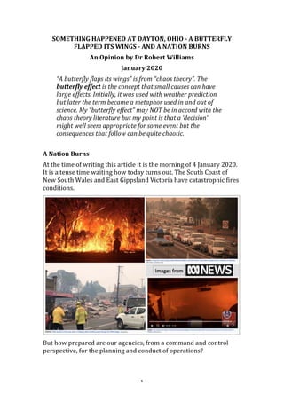
1 SOMETHING HAPPENED AT DAYTON, OHIO - A BUTTERFLY FLAPPED ITS WINGS - AND A NATION BURNS An Opinion by Dr Robert Williams January 2020 “A butterfly flaps its wings” is from “chaos theory”. The butterfly effect is the concept that small causes can have large effects. Initially, it was used with weather prediction but later the term became a metaphor used in and out of science. My “butterfly effect” may NOT be in accord with the chaos theory literature but my point is that a ‘decision‘ might well seem appropriate for some event but the consequences that follow can be quite chaotic. A Nation Burns At the time of writing this article it is the morning of 4 January 2020. It is a tense time waiting how today turns out. The South Coast of New South Wales and East Gippsland Victoria have catastrophic fires conditions. But how prepared are our agencies, from a command and control perspective, for the planning and conduct of operations?
2.
2 Of course, that question is way beyond the scope of an opinion piece and, indeed, requires a major capability study. So, I’ll just review (from my experience and observation) the “mapping” component. For weeks now the morning news have featured a briefing from the New South Wales Rural Fire Service Operations Centre. Figure 1: NSW RFS “Knowledge Wall” The “Knowledge Wall” looks impressive but appears to be composite of simple Google maps with symbols and relatively simple annotation, along with (what appears to be) spreadsheets, media screens, etc. Elsewhere, there are images of paper maps joined together with ‘sticky notes’, notes on walls and scribbled notes on whiteboards. We need to do better. We must have better decision support systems. All of the information in the images needs to be integrated into a geographic, infrastructure and environmental information infrastructure. But, how is it, that entering the third decade of this century, maps and charts are the basis for planning? Why haven’t we evolved into National Geographic Information Infrastructure?
3.
3 Figure 2: It was the week before Christmas 2019 Well, something happened at Dayton, Ohio and a ‘butterfly flapped its wings’! Something Happened at Dayton, Ohio On November 1, 1995, President William Jefferson Clinton called on the warring factions in Bosnia to end the conflict that had cost over three hundred thousand Serb, Croat, and Muslim lives since 1991. He invited their representatives to come to Wright-Patterson Air Force Base in Dayton, Ohio to negotiate an end to the ethnic discord. In Dayton the U.S. delegation relied on a technical team led by the Defense Mapping Agency (DMA) and the U.S. Army Topographic Engineering Center. These agencies drew together a support team of over fifty individuals who digitally mapped the disputed Balkans areas in near-real-time to assist the diplomats in their deliberations. The digital renderings included up-to-date terrain visualization with cultural and economic data relating to potential boundaries. Using automated cartography, computer-assisted map tailoring, and spatial statistical analysis, the team regularly furnished fresh maps
4.
4 reflecting territorial dispositions that had been negotiated less than thirty minutes earlier. The digital technique guaranteed accuracy, consistency, and reliability. The power and flexibility of the technology and the technicians gave the political decision makers the confidence needed to reach agreement. Three-dimensional visual imagery of the disputed areas permitted cartographers to walk negotiators through disputed terrain, giving them a vivid and virtual experience of the space. In at least one instance, this three- dimensional experience proved crucial in persuading Yugoslav President Slobodan Milosevic to compromise on a disputed area. The 1980s was a period of innovation allowing for the first half of the 1990s to bring in a transformation from maps and charts to a geographic information infrastructure. But the 1990s would be a decade of ‘uncertainty’. This transformation had been underway, not only in the US defense mapping agencies, but also in the 5 Nations MC&G group (USA, UK, Canada, Australia and New Zealand / Mapping, Charting and Geodesy), for decades. This transformation reached a ‘revolutionary’ stage in 1994 with the introduction of the Global Geospatial Information and Services Initiative [GGIS]. Defense Mapping Agency – Headquarters (DMA HQ) hosted a meeting for Dr. R. Williams at their Headquarters building on Monday 21 November 1994, at which the agency introduced its Global Geospatial Information and Services Initiative. The concept of Global Geospatial Information and Services (GGIS) was introduced as most revolutionary change in the provision and use of geographic information for many decades. Up until then, digital products have, in most cases, been digital representations of traditional products, such as maps. GGIS offered a managed evolutionary path to electronic distribution of information and services, as well as effectively addressing interoperability issues. The vision, and the road map to achieve it, would facilitate joint interoperability for the Command, Control, Communications and Intelligence (C4I) community. A Task Force of the US Defense Science Board, chaired by Dr Craig Fields, addressed the topic of “Defense Mapping for Future Operations”. Its report was released on 15 September 1995.
5.
5 Figure 3: US DMA GII&S proposal 1994 Figure 4: US Defense Science Board – “Defense Mapping for Future Operations” - 1995
6.
6 This initiative, along with activities of the DGIWG (the Digital Geographic Information Working Group – made up of NATO member agencies and invited non-NATO countries) reached a key moment in 1995. The 24th DGIWG Steering Committee Meeting was held in Berlin, Germany 9 November - 17 November 1995. The US Defense Mapping Agency (DMA) gave number of presentations including: • VMap AD. The DIGEST Dataset AID (Aeronautical Information Dataset) has been split into VMap AD (Aeronautical Data) that contains 'static' aeronautical information and DFlip that will contain more dynamic data. The product is at a prototype stage with development being driven by the F16 upgrade and the Eurofighter project. • Tactical Littoral Data. The Tactical Littoral Dataset (or Littoral Warfare Dataset - LWD) is a value-rich specialist product (being a super set including Terrain Analysis Dataset (TAD), Urban Vector Map (UVMap), Digital Flight Information (DFLIP), Digital Nautical Dataset (DNC)) identified to support missions such as amphibious assault, special operations, mine countermeasures, shallow water ASW and logistics- over-the-shore. Requirements have been provided by US Navy and US Marine Corps and endorsed by ACS C4I USMC (MAJGEN Van Riper) and validated by D DMA (MAJGEN Nuber). This product will be designed to cover the area 200NM either side of the coastline and will include METOC (Meteorology and Oceanography), hydrographic and topographic data in the littoral areas. Policy had been developed, product specifications had been published and prototypes built. It seemed that the time had arrived to transition from producing traditional maps and charts and digital facsimiles of traditional maps and charts to a geospatial information infrastructure. Components of a Geospatial Information Infrastructure along with Prototypes on a Range of Operational Use Had Been Established
7.
7 But, a Butterfly Had Flapped Its Wings! In April 1995, then Director Central Intelligence - designate John Deutch told the [US] Senate Select Committee on Intelligence that, if confirmed, he would "move immediately to consolidate the management of all imagery collection, analysis, and distribution." He argued, "Both effectiveness and economy can be improved by managing imagery in a manner similar to the National Security Agency's organization for signals intelligence.” Despite reservations and objections, Deutch and Secretary of Defense William Perry informed Congress in late November 1995 of their plans to establish a National Imagery and Mapping Agency (NIMA) as a combat support agency within the Department of Defense on October 1, 1996. Figure 5: US NIMA Geospatial Information Infrastructure Master Plan 1997 A Geospatial Information Infrastructure Master Plan commenced by US Defense Mapping Agency was completed by the Integrated Product Team of the successor agency National Imagery and Mapping Agency and published on 17 October 1997. The Geospatial Information Infrastructure (GII) Master Plan included the Vision as “Our national security can be enhanced by an ‘information edge’ made possible through this new infrastructure for geospatial information. The
8.
8 infrastructure is the collection of people, doctrine, policies, architectures, standards, and technologies necessary to create, maintain, and utilize a shared geospatial framework”. The creation of NIMA appears to be logical as shown in the figure produced on NGA’s (National Geospatial-Intelligence Agency) creation in 2003. The creation of NIMA bought together agencies with fundamentally different cultures. The discussion on the topic has been simplified as between ‘imagery analysts’ and ‘cartographers’. My view is that this can be seen as an ‘intelligence view’ versus an ‘engineer view’ and that this flows onto scientific and engineering disciplines. Figure 6: Creation of US NIMA 1996
9.
9 Figure 7: Commentary on US NIMA 1999 Figure 8: Los Angeles Times - Commentary on US NIMA 1999 The early years of NIMA were characterised by a number of incidents that were reported in the media as for Sunday’s edition of the “Los Angeles Times” [16 May, 1999]. I was at Redlands, CA then for a visit to ESRI on the Monday. It was an interesting visit!
10.
10 The formation of NIMA initiated a trend for senior leadership to be ‘intelligence’ officers with few senior officers from the ‘engineering’ field. An event would occur that would entrench that trend. Figure 9: A Change in World Order – 911 2001 Meanwhile, in Australia a number of organisational changes were underway in Defence that resulted in the formation of the Defence Imagery and Geospatial Organisation (DIGO) and in the ‘Intelligence’ program [not an intelligence agency]. DIGO was formed on 8 November 2000 and would become an intelligence agency on 2 December 2005. The 2000s would be A Decade in Disarray with Disruptive Direction. The initiatives prior to NIMA’s formation would be mostly ignored and so the production of standard maps and charts, and digital facsimiles of standard maps and charts, remains until today (see following illustrations). In addition, senior leadership [in Defense / Defence / Military organisations] has limited representation from ‘engineer’ officers. NGA maintains a website that provides information on ‘leaders’. Leadership has a dominant ‘intelligence’ focus with very few with formal qualifications in engineering, surveying/geodesy and
11.
11 cartography (science) qualifications – (Illustration follows NIMA/NGA illustrations). Figure 10: Digital facsimiles of traditional products – “swap hard copy atlases with online versions”, NGA Director at U.S. Geospatial Intelligence Foundation GEOINT Symposium 2011. Figure 11: The NGA Mission – YouTube video 2013 https://www.youtube.com/watch?v=VZz5HBALMqE
12.
12 Figure 12: Letitia A. Long (Director, National Geospatial-Intelligence Agency) In conversation with Jack Dangermond, 2014 – “For industry, we need your help in developing … Automated production of standard maps and charts for the Map of the World”. Figure 13: NGA Public Website to Support Nepal Earthquake Relief efforts, 2015 – Standard topographic maps, annotated imagery with text descriptions and simple GIS products.
13.
13 Figure 14: [Australia Defence] Geospatial Information Infrastructure – JP2064 – Joint Project 2064 had its origins in 1997. In 2004 the project had (proposed) functionality to assist emergency organisations. This was removed sometime between 2004 and 2012 (presumably) as a cost saving option. Figure 15: “From data silos to integrated content: delivering richer and more accessible GEOINT”, AGO (Australian Geospatial-Intelligence Organisation) Ass. Sec, GEOINT at Locate16, 2016 – “Multinational Geospatial Co-production Program (MGCP), which currently involves 32 nations and is aimed at producing 1:100 000 scale maps of the entire world”
14.
14 Figure 15: Selection of Executive Level officers and formal qualifications In summary, organisational changes in the later half of the 1990s catalysed by decisions made immediately following the 911 incident have resulted in a failure to evolve from a standard map and chart paradigm to a geographic information infrastructure paradigm. This situation spread through various nations and institutions. The result, from my observation of command support to our 2019- 2020 fires, is that maps and facsimiles and simple representations are the norm. It’s time for change Our ‘firies’ were underprepared for the extreme weather and environmental conditions that occurred over vast areas and over a long period of time. They struggled under very difficult circumstances to improvise the response against an extreme challenge that they had never encountered, and honestly never been trained to meet. We must do better. We need to go ‘Back to the Future’! We need to understand what “butterfly” effects have occurred and what needs to be done to rectify the situation.
15.
15 Figure 16: It was the first week of the New Year 2020 Over the past 25 years or so, the tertiary education for mapmakers, such cartographers, has been reduced to the level of generic "spatial science". We do not expect a physicist or chemist to build a bridge, even though they could provide great detail about the forces acting on the structure. Instead, we employ engineers. Likewise, we should not expect zoologists, physicists, economists, political scientists, or environmental scientists to manage cartographic organisations. That, however, is what is happening now. The point of this opinion piece is that we have a core capability that is decades behind where it should be had not ill-informed advice interrupted development. We need to acknowledge that surveying and cartography are core scientific disciplines fundamental to a capability that provides the framework and information for the development of a nation; the managements of its infrastructure and environment; and the safety and well-being of its people. As such, specialist organisations with appropriately qualified leadership are essential! Over forty years ago Desmond O’Connor, Foundation Professor at Murdoch University suggested that
16.
16 “Cartographers should be thinking of a broadly defined concept for the operational use of modern sensors, the full range of data processing equipment and methodology, and large scale communication devices receiving input from space, airborne and terrestrial platforms for the purpose of carrying out surveys of the earth’s surface, monitoring the environment, and classifying and compacting the information in environmental data banks so that real-time or near real- time information may be provided when and where it is required”. We need to embrace Desmond O’Connor’s vision of four decades ago if we seriously wish to address the challenges of “Meeting the Environmental Crisis” and “Safeguarding Australia”.
Download now