Best Call Girls In Sector 29 Gurgaon❤️8860477959 EscorTs Service In 24/7 Delh...
4770639.ppt
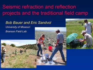
1. Seismic refraction and reflection
projects and the traditional field camp
Bob Bauer and Eric Sandvol
University of Missouri
Branson Field Lab
2. Presentation Overview
• Traditional aspects of our course
• Evolution of our incorporation of
geophysics projects
• Instructional context for our
geophysics projects
• Seismic refraction project for all
students
• Advanced seismic refraction and
reflection option for students
Camp Branson
3. Four weeks of a
traditional field course
• Introductory field methods
• Stratigraphic sections
• Sedimentary facies and
stratigraphy
• Mapping of folded and faulted
sedimentary units
• Regional geology instruction
and 4-day trip
Yellowstone, Tetons, SRP,
Beartooth, Heart Mtn detachment
• Hard-rock structural analysis
Camp Branson
4. Traditional 5th and 6th week
• 5th week projects in
mapping of more
complex folded and
faulted sedimentary
rocks
• 6th week projects in
structural analysis and
mapping in
Precambrian
metamorphic and
plutonics rocks
5. The Evolution of our approach
• Several years of short
seismic refraction and
hydrology projects
• Nature Conservancy
land in Red Canyon
Objective:
To provide a wider array of project
disciplines without expanding our
pre-requisite courses -
Historical, Sed/Strat, Structure
6. In 2005 we instituted a new approach to the
5th and 6th weeks of our course based on an
NSF CCLI equipment grant
• Seismic equipment:
– Geometrics® - Geode
24 channel seismic
recorders and
packaged software
– Seismic cable
– Geophones
– Tough-book laptop
(+ existing laptops)
7. The 5th week instruction introduces all students to
several new projects that can be completed in the
same general location:
• Shallow seismic refraction
(Eric Sandvol)
• Groundwater hydrology
(Don Siegel)
• Surfacewater hydrology
(Laura Lautz)
• Stream terrace mapping
(Dennis Dahms)
- No pre-requisite courses in
geophysics, hydrogeology or
geomorphology
- All projects completed by
three-person teams
- Include lecture and field
instruction daily to small
groups of teams -supergroups
8. For the 6th week of instruction, students
choose one of three advanced project options
• Hydrogeology (Siegel and Lautz)
– Multiple (5) 1-day projects (2/group)
– Daily reports due each evening
• Hard-rock structural analysis and mapping
– (Bauer)
– 4-day mapping and data collection ( 3/group)
– Evening data plotting & analysis
– 1 day to prepare map, data plots & report
• Geophysics (Sandvol)
– Two projects (2/group – analysis & reports))
– 1 day each of data collection (all students)
– 1 day each of computer processing in camp
– 1 day to write second project report
9. 5th Week – Seismic Refraction
• One-day project completed by all students
• Morning lecture to supergroup (9-12 people)
• Data collection by supergroups,
• Analysis & reports by 3-person groups
• General objective: give all students a basic background in
how seismic waves can be used to image the subsurface
• Local objective: determine whether seismic refraction
techniques can be used to image the shallow floodplain
strata or the groundwater table
10. Introductory Lecture & Instruction
• Snell’s law
• Travel times in a layered Earth
• Time-distance relationships
• Critical angle
• Travel times of seismic waves &
dipping layers
• Cross-over distance
• Experiment design
• Picking 1st arrivals
• Interpretation techniques Reference reading in Burger (1992)
Exploration geophysics of the shallow
subsurface
11. Field Equipment & Design
• 32-channel Geode Seismic Data
Acquisitions system with a sledge
hammer source
• Students design their own seismic
profile to image shallow seismic
boundaries (1.5-2 meters deep)
beneath the floodplain
• Deploy thirty-two geophones and collect
the data themselves
12. Data analysis in the lab
• The number of layers
that the data support
• The travel time of the
first arriving P-waves
• The velocity and layer
thicknesses for each
layer using ray theory
calculations
Using an interactive computer program on laptop
computers students determine:
Formulate a 1-D seismic
velocity model that best
fits the data
13. Interpretation in geologic context
• Seismic experiment at the same field
site as the ongoing hydrology projects
• Students use their measurements of
groundwater depth to interpret their
seismic velocity models
• Water table generally causes the
largest velocity change at this site
• The students see how the shallow
geophysical measurements can be
integrated with the hydrology projects
14. 6th week
geophysics option
• Two separate projects:
– Refraction processing using time-term analysis and
refraction tomography
– Reflection processing using muting, filtering, and
normal moveout corrections
• Students learn to:
– Design data acquisition for a target depth
– Determine if refraction or reflection data analysis is
most appropriate for the problem
– Interpret the results in a familiar geologic context
• Most student have previous geophysics course
15. Each project involves:
• Data acquired using:
– 32-channel Geometrics
Geodes
– 10 Hz geophones
– Betsy (shotgun shell) source
• One-day data collection in an
area where student have
previously mapped
• One-day data analysis in the lab
• General instruction on:
– the data acquisition process
– seismic survey design
– data analysis techniques
16. Refraction data collection
and processing
• Used thee time-term
method to estimate
refractor depth
• Software package
Plotrefa to calculate
the velocities for an n-
layer model
• Used a tomographic
analysis to model travel
time data
17. Reflection data collection
and processing using
seismic UNIX (SUNT)
• Survey design – split spread, CDP gathers
• Normal move-out corrections
• Calculating layer thicknesses
• Stacking concepts (CMP and CDP stacking)
• Static corrections
• Fold calculations
• Processing steps
• Interpretations
18. Conclusions
• Our two-part approach to teaching seismic field
techniques and analysis allows us to:
– Provide all students with basic instruction in elementary seismic
techniques
– Provide students with specific interests in seismology with both
field data collection experience and experience in applying a
wide variety of seismic processing techniques
• Both project levels are provided in a field context already
familiar to the students from previous projects