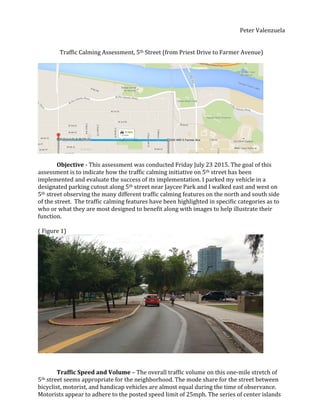
SlideShare a Scribd company logo
1 of 4
Download to read offline
 
Peter	
  Valenzuela	


Traffic	
  Calming	
  Assessment,	
  5th	
  Street	
  (from	
  Priest	
  Drive	
  to	
  Farmer	
  Avenue)	


Objective	
  -­‐	
  This	
  assessment	
  was	
  conducted	
  Friday	
  July	
  23	
  2015.	
  The	
  goal	
  of	
  this	
  
assessment	
  is	
  to	
  indicate	
  how	
  the	
  traffic	
  calming	
  initiative	
  on	
  5th	
  street	
  has	
  been	
  
implemented	
  and	
  evaluate	
  the	
  success	
  of	
  its	
  implementation.	
  I	
  parked	
  my	
  vehicle	
  in	
  a	
  
designated	
  parking	
  cutout	
  along	
  5th	
  street	
  near	
  Jaycee	
  Park	
  and	
  I	
  walked	
  east	
  and	
  west	
  on	
  
5th	
  street	
  observing	
  the	
  many	
  different	
  traffic	
  calming	
  features	
  on	
  the	
  north	
  and	
  south	
  side	
  
of	
  the	
  street.	
  	
  The	
  traffic	
  calming	
  features	
  have	
  been	
  highlighted	
  in	
  specific	
  categories	
  as	
  to	
  
who	
  or	
  what	
  they	
  are	
  most	
  designed	
  to	
  benefit	
  along	
  with	
  images	
  to	
  help	
  illustrate	
  their	
  
function.	


(	
  Figure	
  1)	


Traffic	
  Speed	
  and	
  Volume	
  –	
  The	
  overall	
  traffic	
  volume	
  on	
  this	
  one-­‐mile	
  stretch	
  of	
  
5th	
  street	
  seems	
  appropriate	
  for	
  the	
  neighborhood.	
  The	
  mode	
  share	
  for	
  the	
  street	
  between	
  
bicyclist,	
  motorist,	
  and	
  handicap	
  vehicles	
  are	
  almost	
  equal	
  during	
  the	
  time	
  of	
  observance.	
  
Motorists	
  appear	
  to	
  adhere	
  to	
  the	
  posted	
  speed	
  limit	
  of	
  25mph.	
  The	
  series	
  of	
  center	
  islands	
  
 
(Figure	
  1)	
  situated	
  along	
  the	
  street	
  have	
  narrowed	
  the	
  road,	
  forcing	
  motorist	
  to	
  be	
  more	
  
aware	
  of	
  the	
  bike	
  lane.	
  The	
  narrowing	
  of	
  the	
  street	
  does	
  appear	
  to	
  make	
  emergency	
  vehicle	
  
travel	
  more	
  difficult.	
  At	
  certain	
  points	
  larger	
  emergency	
  vehicles	
  will	
  be	
  forced	
  to	
  drive	
  in	
  
the	
  designated	
  bike	
  lane,	
  or	
  take	
  up	
  both	
  driving	
  lanes.	


(Figure	
  2)	


Streets	
  and	
  Intersections	
  –	
  Cross	
  walks	
  are	
  provided	
  at	
  all	
  intersections	
  and	
  
midblock	
  locations,	
  and	
  are	
  distinctly	
  marked	
  (Figure	
  2).	
  The	
  streets	
  are	
  narrow	
  enough	
  to	
  
allow	
  elderly	
  pedestrians	
  to	
  cross	
  at	
  mid	
  block	
  locations	
  in	
  a	
  timely	
  manner	
  with	
  out	
  
impeding	
  motor	
  vehicles.	
  The	
  intersections	
  of	
  5th	
  street	
  have	
  adequate	
  textured	
  curb	
  cuts	
  
leading	
  in	
  multiple	
  directions	
  to	
  accommodate	
  handicap	
  travelers.	
  The	
  largest	
  intersection	
  
on	
  5th	
  street	
  and	
  Hardy	
  (Figure	
  2)	
  features	
  a	
  raised	
  and	
  textured	
  center;	
  making	
  motorist	
  
more	
  aware	
  of	
  the	
  bicycle	
  and	
  pedestrian	
  emphasis	
  on	
  the	
  street.	
  The	
  analysis	
  was	
  
conducted	
  during	
  the	
  day	
  however;	
  there	
  was	
  no	
  presence	
  of	
  lighting	
  designating	
  any	
  
pedestrian	
  crossing	
  areas	
  to	
  optimize	
  travel	
  at	
  night.	


(Figure	
  3)	


A.	


  B.	


  C.	


Pedestrian	
  Facilities	
  –	
  The	
  sidewalks	
  situated	
  along	
  5th	
  street	
  are	
  wide	
  enough	
  to	
  
accommodate	
  two	
  pedestrians	
  walking	
  abreast.	
  Some	
  areas	
  contain	
  rock	
  and	
  shrub	
  features	
  
Aerial View
 
that	
  create	
  a	
  vertical	
  separation	
  between	
  the	
  sidewalk	
  and	
  the	
  street	
  as	
  exhibited	
  in	
  (Figure	
  
3	
  A	
  and	
  C).	
  	
  There	
  are	
  no	
  exhibited	
  obstructions	
  along	
  the	
  continuous	
  sidewalk	
  to	
  inhibit	
  
handicap	
  pedestrians,	
  and	
  there	
  is	
  excellent	
  shade	
  provided	
  by	
  trees.	


(Figure	
  4)	
  A.	


  B.	


Bicycle	
  Facilities	
  –	
  A	
  designated	
  bike	
  lane	
  is	
  provided	
  on	
  the	
  street.	
  The	
  traffic	
  
speed	
  is	
  accommodating	
  to	
  bicyclist	
  as	
  well.	
  At	
  the	
  main	
  intersection	
  on	
  5th	
  and	
  Hardy,	
  there	
  
are	
  vertical	
  barrier	
  features	
  that	
  separate	
  bicyclist	
  from	
  the	
  street	
  where	
  vehicles	
  make	
  
turns	
  displayed	
  in	
  (Figure	
  4	
  A).	
  The	
  barriers	
  allow	
  separation	
  and	
  designation	
  from	
  vehicles.	
  
Along	
  5th	
  street	
  the	
  smaller	
  streets	
  that	
  feed	
  into	
  the	
  neighborhoods	
  feature	
  well	
  marked	
  
stop	
  lines	
  (Figure	
  4	
  B)	
  far	
  enough	
  away	
  from	
  the	
  street	
  to	
  allow	
  motorist	
  to	
  check	
  for	
  
bicyclist	
  and	
  pedestrians	
  before	
  turning.	


(Figure	
  5)	
  A.	


B.	


Transit	
  Facilities	
  -­‐	
  There	
  is	
  transit	
  service	
  provided	
  along	
  5th	
  street.	
  The	
  sidewalk	
  in	
  
front	
  of	
  the	
  transit	
  stops	
  is	
  wide	
  enough	
  for	
  handicap	
  travelers.	
  There	
  are	
  not	
  many	
  other	
  
amenities	
  for	
  the	
  transit	
  service	
  however.	
  	
  The	
  transit	
  stops	
  are	
  not	
  extremely	
  well	
  lit	
  along	
  the	
  
length	
  of	
  5th	
  street.	
  There	
  are	
  no	
  structures	
  or	
  trees	
  situated	
  above	
  the	
  transit	
  stops	
  (Figure	
  5	
  A)	
  	
  
to	
  protect	
  against	
  the	
  elements.	
  The	
  transit	
  signs	
  are	
  also	
  very	
  small	
  and	
  potentially	
  difficult	
  to	
  
notice	
  or	
  read	
  for	
  elderly	
  travelers.	
  (Figure	
  5	
  B)	


Safety	
  and	
  Security	
  –	
  The	
  lighting	
  along	
  the	
  sidewalk	
  is	
  provided	
  by	
  streetlight,	
  which	
  
gives	
  limited	
  light	
  coverage.	
  There	
  is	
  no	
  street	
  level	
  lighting.	
  There	
  are	
  many	
  residential	
  buildings	
  
lining	
  the	
  sidewalks	
  so	
  the	
  sense	
  of	
  being	
  monitored	
  provides	
  sense	
  of	
  safety.	
  The	
  parking	
  areas	
  
along	
  the	
  street	
  have	
  adequate	
  lighting.	
  There	
  was	
  no	
  strong	
  presence	
  of	
  police	
  vehicles	
  during	
  
analysis.	
  There	
  is	
  an	
  over	
  all	
  sense	
  of	
  security	
  during	
  the	
  day.	


Findings	
  –	
  The	
  traffic	
  calming	
  features	
  added	
  to	
  5th	
  street	
  appear	
  to	
  be	
  effective	
  in	
  
deterring	
  motorist	
  from	
  using	
  the	
  street	
  and	
  for	
  speeding	
  as	
  well.	
  The	
  center	
  islands	
  situated	
  
along	
  5th	
  street	
  have	
  severely	
  narrowed	
  the	
  street	
  and	
  during	
  the	
  assessment	
  there	
  were	
  very	
  
little	
  vehicles	
  using	
  it.	
  Narrow	
  streets	
  and	
  low	
  speed	
  limits	
  seem	
  to	
  be	
  calming	
  vehicle	
  traffic,	
  and	
  
deterring	
  its	
  use	
  as	
  a	
  cut	
  through	
  street.	


Pedestrian	
  travel	
  has	
  improved	
  significantly	
  along	
  5th	
  street	
  due	
  to	
  the	
  traffic	
  calming	
  
efforts.	
  Wider	
  sidewalks	
  and	
  well-­‐placed	
  trees	
  create	
  an	
  aesthetic	
  and	
  pleasantly	
  shaded	
  walking	
  
experience.	
  The	
  narrowing	
  of	
  the	
  street	
  and	
  mid	
  block	
  crosswalks	
  also	
  make	
  traveling	
  along	
  and	
  
through	
  5th	
  street	
  more	
  convenient	
  and	
  safe.	
  Well-­‐designed	
  bike	
  lanes	
  have	
  made	
  biking	
  much	
  
safer	
  and	
  appealing	
  by	
  segregating	
  the	
  bike	
  lanes	
  with	
  landscape	
  medians	
  near	
  intersections.	
  
Bicycling	
  was	
  the	
  most	
  noticeable	
  mode	
  of	
  travel	
  being	
  used	
  during	
  the	
  assessment.	
  	
  
There	
  is	
  a	
  senior	
  center	
  situated	
  on	
  5th	
  street	
  between	
  Roosevelt	
  and	
  Hardy.	
  During	
  the	
  
assessment	
  there	
  were	
  several	
  senior	
  citizens	
  using	
  motorized	
  scooters	
  to	
  travel	
  down	
  5th	
  street.	
  
The	
  sidewalks	
  were	
  wide	
  enough	
  for	
  them	
  to	
  maneuver	
  around	
  pedestrians	
  and	
  curb	
  cuts	
  at	
  the	
  
intersections	
  allowed	
  them	
  to	
  cross	
  with	
  ease.	
  Physically	
  disabled	
  travelers	
  would	
  benefit	
  from	
  
these	
  features	
  as	
  well.	


More Related Content

What's hot

Ongoing broad ave initial improvement plan
Ongoing broad ave initial improvement planOngoing broad ave initial improvement plan
Ongoing broad ave initial improvement planBorough of Leonia
 
Site analysis check list
Site analysis check listSite analysis check list
Site analysis check listNicky Wong
 
Pedestrian Access Improvements: Burke Lake Road at Coffer Woods Road
Pedestrian Access Improvements: Burke Lake Road at Coffer Woods RoadPedestrian Access Improvements: Burke Lake Road at Coffer Woods Road
Pedestrian Access Improvements: Burke Lake Road at Coffer Woods RoadFairfax County
 
Scotts Run Trail to McLean Metro Station January 2021
Scotts Run Trail to McLean Metro Station January 2021Scotts Run Trail to McLean Metro Station January 2021
Scotts Run Trail to McLean Metro Station January 2021Fairfax County
 
Brea atp open house_presentation_evening public workshop
Brea atp open house_presentation_evening public workshopBrea atp open house_presentation_evening public workshop
Brea atp open house_presentation_evening public workshopDarin Dinsmore
 
Potosi Sidewalk Plan
Potosi Sidewalk PlanPotosi Sidewalk Plan
Potosi Sidewalk PlanBrody Johnson
 
Edinburgh Harbour Forth Ports Planning Application
Edinburgh Harbour Forth Ports Planning ApplicationEdinburgh Harbour Forth Ports Planning Application
Edinburgh Harbour Forth Ports Planning ApplicationGreener Leith
 
Dangerous by design intersections in the tmc
Dangerous by design intersections in the tmcDangerous by design intersections in the tmc
Dangerous by design intersections in the tmcDoug House
 
FINAL HANDBOOK
FINAL HANDBOOKFINAL HANDBOOK
FINAL HANDBOOKNeha Tambe
 
Substantial Completion: Franconia Road Sidewalk
Substantial Completion: Franconia Road SidewalkSubstantial Completion: Franconia Road Sidewalk
Substantial Completion: Franconia Road SidewalkFairfax County
 
Clairemont ad hoc subcommittee presentation 11/2/16
Clairemont ad hoc subcommittee presentation 11/2/16 Clairemont ad hoc subcommittee presentation 11/2/16
Clairemont ad hoc subcommittee presentation 11/2/16 omedina91
 
Clairemont subcommittee presentation 07.19.17
Clairemont subcommittee presentation  07.19.17Clairemont subcommittee presentation  07.19.17
Clairemont subcommittee presentation 07.19.17CirculateSD
 
Aspen Hill MMPA Transportation Section & Appendix May '15
Aspen Hill MMPA Transportation Section & Appendix May '15Aspen Hill MMPA Transportation Section & Appendix May '15
Aspen Hill MMPA Transportation Section & Appendix May '15Aaron Zimmerman, PTP
 
Pacific Beach ad hoc subcommittee presentation 11/3/16
Pacific Beach ad hoc subcommittee presentation 11/3/16Pacific Beach ad hoc subcommittee presentation 11/3/16
Pacific Beach ad hoc subcommittee presentation 11/3/16omedina91
 
Ce 4710 presentation 2
Ce 4710 presentation 2Ce 4710 presentation 2
Ce 4710 presentation 2Matthew White
 

What's hot (20)

Task 10: Community Meeting Notes & Comments
Task 10:  Community Meeting Notes & CommentsTask 10:  Community Meeting Notes & Comments
Task 10: Community Meeting Notes & Comments
 
De witt final_report_180213
De witt final_report_180213De witt final_report_180213
De witt final_report_180213
 
Ongoing broad ave initial improvement plan
Ongoing broad ave initial improvement planOngoing broad ave initial improvement plan
Ongoing broad ave initial improvement plan
 
Site analysis check list
Site analysis check listSite analysis check list
Site analysis check list
 
Pedestrian Access Improvements: Burke Lake Road at Coffer Woods Road
Pedestrian Access Improvements: Burke Lake Road at Coffer Woods RoadPedestrian Access Improvements: Burke Lake Road at Coffer Woods Road
Pedestrian Access Improvements: Burke Lake Road at Coffer Woods Road
 
Scotts Run Trail to McLean Metro Station January 2021
Scotts Run Trail to McLean Metro Station January 2021Scotts Run Trail to McLean Metro Station January 2021
Scotts Run Trail to McLean Metro Station January 2021
 
Brea atp open house_presentation_evening public workshop
Brea atp open house_presentation_evening public workshopBrea atp open house_presentation_evening public workshop
Brea atp open house_presentation_evening public workshop
 
TOD Presentation-PDF_-part-II
TOD Presentation-PDF_-part-IITOD Presentation-PDF_-part-II
TOD Presentation-PDF_-part-II
 
SMART STEP Project: SE 8th Street & Brickell Avenue
SMART STEP Project: SE 8th Street & Brickell AvenueSMART STEP Project: SE 8th Street & Brickell Avenue
SMART STEP Project: SE 8th Street & Brickell Avenue
 
Potosi Sidewalk Plan
Potosi Sidewalk PlanPotosi Sidewalk Plan
Potosi Sidewalk Plan
 
Edinburgh Harbour Forth Ports Planning Application
Edinburgh Harbour Forth Ports Planning ApplicationEdinburgh Harbour Forth Ports Planning Application
Edinburgh Harbour Forth Ports Planning Application
 
Dangerous by design intersections in the tmc
Dangerous by design intersections in the tmcDangerous by design intersections in the tmc
Dangerous by design intersections in the tmc
 
November 3, 2021 CTAC Virtual Workshop
November 3, 2021 CTAC Virtual WorkshopNovember 3, 2021 CTAC Virtual Workshop
November 3, 2021 CTAC Virtual Workshop
 
FINAL HANDBOOK
FINAL HANDBOOKFINAL HANDBOOK
FINAL HANDBOOK
 
Substantial Completion: Franconia Road Sidewalk
Substantial Completion: Franconia Road SidewalkSubstantial Completion: Franconia Road Sidewalk
Substantial Completion: Franconia Road Sidewalk
 
Clairemont ad hoc subcommittee presentation 11/2/16
Clairemont ad hoc subcommittee presentation 11/2/16 Clairemont ad hoc subcommittee presentation 11/2/16
Clairemont ad hoc subcommittee presentation 11/2/16
 
Clairemont subcommittee presentation 07.19.17
Clairemont subcommittee presentation  07.19.17Clairemont subcommittee presentation  07.19.17
Clairemont subcommittee presentation 07.19.17
 
Aspen Hill MMPA Transportation Section & Appendix May '15
Aspen Hill MMPA Transportation Section & Appendix May '15Aspen Hill MMPA Transportation Section & Appendix May '15
Aspen Hill MMPA Transportation Section & Appendix May '15
 
Pacific Beach ad hoc subcommittee presentation 11/3/16
Pacific Beach ad hoc subcommittee presentation 11/3/16Pacific Beach ad hoc subcommittee presentation 11/3/16
Pacific Beach ad hoc subcommittee presentation 11/3/16
 
Ce 4710 presentation 2
Ce 4710 presentation 2Ce 4710 presentation 2
Ce 4710 presentation 2
 

Similar to Complete Streets Traffic Calming Assessment

North quarter vision study
North quarter vision studyNorth quarter vision study
North quarter vision studyBrendan O'Connor
 
Roadway condition presentation grp 04
Roadway condition presentation grp 04Roadway condition presentation grp 04
Roadway condition presentation grp 04Stone Rayhan
 
Muizenberg Accessibility
Muizenberg AccessibilityMuizenberg Accessibility
Muizenberg AccessibilityKevin Rack
 
Urban Transportation Systems: Redesigning Main Street
Urban Transportation Systems: Redesigning Main Street Urban Transportation Systems: Redesigning Main Street
Urban Transportation Systems: Redesigning Main Street Julianne Crawford
 
2015.06.10 Urbane Streets - Ridgefield - Multimodal Network Tech - Memo 1 Exi...
2015.06.10 Urbane Streets - Ridgefield - Multimodal Network Tech - Memo 1 Exi...2015.06.10 Urbane Streets - Ridgefield - Multimodal Network Tech - Memo 1 Exi...
2015.06.10 Urbane Streets - Ridgefield - Multimodal Network Tech - Memo 1 Exi...Todd Boulanger
 
Re imagining yonge street mcea study - pic 2 display panels low res
Re imagining yonge street mcea study - pic 2 display panels low resRe imagining yonge street mcea study - pic 2 display panels low res
Re imagining yonge street mcea study - pic 2 display panels low resknelischer
 
Urban Design Scales and Spaces for Architecture
Urban Design Scales and Spaces for ArchitectureUrban Design Scales and Spaces for Architecture
Urban Design Scales and Spaces for ArchitectureMimi Alguidano
 
Balboa Station Plan Alternatives
Balboa Station Plan AlternativesBalboa Station Plan Alternatives
Balboa Station Plan AlternativesCirculateSD
 
Cycleway realignment
Cycleway realignmentCycleway realignment
Cycleway realignmentNaoise
 
World usa pres_2017_en_systematic safety - action plan for boston_pfurth
World usa pres_2017_en_systematic safety - action plan for boston_pfurthWorld usa pres_2017_en_systematic safety - action plan for boston_pfurth
World usa pres_2017_en_systematic safety - action plan for boston_pfurthpatxigalarraga
 
Clifton Avenue Streetscape Design - Posters
Clifton Avenue Streetscape Design - PostersClifton Avenue Streetscape Design - Posters
Clifton Avenue Streetscape Design - PostersJake Henderson
 
Manor Park Neighborhood Urban Park
Manor Park Neighborhood Urban ParkManor Park Neighborhood Urban Park
Manor Park Neighborhood Urban ParkJose Carlos Ayala
 

Similar to Complete Streets Traffic Calming Assessment (20)

North quarter vision study
North quarter vision studyNorth quarter vision study
North quarter vision study
 
Technical Report
Technical ReportTechnical Report
Technical Report
 
Park hill walkability report single document
Park hill walkability report   single documentPark hill walkability report   single document
Park hill walkability report single document
 
Roadway condition presentation grp 04
Roadway condition presentation grp 04Roadway condition presentation grp 04
Roadway condition presentation grp 04
 
Muizenberg Accessibility
Muizenberg AccessibilityMuizenberg Accessibility
Muizenberg Accessibility
 
Urban redevelopment
Urban redevelopmentUrban redevelopment
Urban redevelopment
 
Urban Transportation Systems: Redesigning Main Street
Urban Transportation Systems: Redesigning Main Street Urban Transportation Systems: Redesigning Main Street
Urban Transportation Systems: Redesigning Main Street
 
GW-Codman-all
GW-Codman-allGW-Codman-all
GW-Codman-all
 
Fix Fifth
Fix FifthFix Fifth
Fix Fifth
 
2015.06.10 Urbane Streets - Ridgefield - Multimodal Network Tech - Memo 1 Exi...
2015.06.10 Urbane Streets - Ridgefield - Multimodal Network Tech - Memo 1 Exi...2015.06.10 Urbane Streets - Ridgefield - Multimodal Network Tech - Memo 1 Exi...
2015.06.10 Urbane Streets - Ridgefield - Multimodal Network Tech - Memo 1 Exi...
 
Re imagining yonge street mcea study - pic 2 display panels low res
Re imagining yonge street mcea study - pic 2 display panels low resRe imagining yonge street mcea study - pic 2 display panels low res
Re imagining yonge street mcea study - pic 2 display panels low res
 
Urban Design Scales and Spaces for Architecture
Urban Design Scales and Spaces for ArchitectureUrban Design Scales and Spaces for Architecture
Urban Design Scales and Spaces for Architecture
 
Balboa Station Plan Alternatives
Balboa Station Plan AlternativesBalboa Station Plan Alternatives
Balboa Station Plan Alternatives
 
Cycleway realignment
Cycleway realignmentCycleway realignment
Cycleway realignment
 
World usa pres_2017_en_systematic safety - action plan for boston_pfurth
World usa pres_2017_en_systematic safety - action plan for boston_pfurthWorld usa pres_2017_en_systematic safety - action plan for boston_pfurth
World usa pres_2017_en_systematic safety - action plan for boston_pfurth
 
Clifton Avenue Streetscape Design - Posters
Clifton Avenue Streetscape Design - PostersClifton Avenue Streetscape Design - Posters
Clifton Avenue Streetscape Design - Posters
 
Livable Burbank
Livable BurbankLivable Burbank
Livable Burbank
 
Section 2 Inventory and Assessment
Section 2  Inventory and AssessmentSection 2  Inventory and Assessment
Section 2 Inventory and Assessment
 
Wellington St Upgrade
Wellington St UpgradeWellington St Upgrade
Wellington St Upgrade
 
Manor Park Neighborhood Urban Park
Manor Park Neighborhood Urban ParkManor Park Neighborhood Urban Park
Manor Park Neighborhood Urban Park
 

Complete Streets Traffic Calming Assessment

  • 1.   Peter  Valenzuela       Traffic  Calming  Assessment,  5th  Street  (from  Priest  Drive  to  Farmer  Avenue)         Objective  -­‐  This  assessment  was  conducted  Friday  July  23  2015.  The  goal  of  this   assessment  is  to  indicate  how  the  traffic  calming  initiative  on  5th  street  has  been   implemented  and  evaluate  the  success  of  its  implementation.  I  parked  my  vehicle  in  a   designated  parking  cutout  along  5th  street  near  Jaycee  Park  and  I  walked  east  and  west  on   5th  street  observing  the  many  different  traffic  calming  features  on  the  north  and  south  side   of  the  street.    The  traffic  calming  features  have  been  highlighted  in  specific  categories  as  to   who  or  what  they  are  most  designed  to  benefit  along  with  images  to  help  illustrate  their   function.       (  Figure  1)         Traffic  Speed  and  Volume  –  The  overall  traffic  volume  on  this  one-­‐mile  stretch  of   5th  street  seems  appropriate  for  the  neighborhood.  The  mode  share  for  the  street  between   bicyclist,  motorist,  and  handicap  vehicles  are  almost  equal  during  the  time  of  observance.   Motorists  appear  to  adhere  to  the  posted  speed  limit  of  25mph.  The  series  of  center  islands  
  • 2.   (Figure  1)  situated  along  the  street  have  narrowed  the  road,  forcing  motorist  to  be  more   aware  of  the  bike  lane.  The  narrowing  of  the  street  does  appear  to  make  emergency  vehicle   travel  more  difficult.  At  certain  points  larger  emergency  vehicles  will  be  forced  to  drive  in   the  designated  bike  lane,  or  take  up  both  driving  lanes.           (Figure  2)     Streets  and  Intersections  –  Cross  walks  are  provided  at  all  intersections  and   midblock  locations,  and  are  distinctly  marked  (Figure  2).  The  streets  are  narrow  enough  to   allow  elderly  pedestrians  to  cross  at  mid  block  locations  in  a  timely  manner  with  out   impeding  motor  vehicles.  The  intersections  of  5th  street  have  adequate  textured  curb  cuts   leading  in  multiple  directions  to  accommodate  handicap  travelers.  The  largest  intersection   on  5th  street  and  Hardy  (Figure  2)  features  a  raised  and  textured  center;  making  motorist   more  aware  of  the  bicycle  and  pedestrian  emphasis  on  the  street.  The  analysis  was   conducted  during  the  day  however;  there  was  no  presence  of  lighting  designating  any   pedestrian  crossing  areas  to  optimize  travel  at  night.       (Figure  3)       A.                          B.                                                  C.       Pedestrian  Facilities  –  The  sidewalks  situated  along  5th  street  are  wide  enough  to   accommodate  two  pedestrians  walking  abreast.  Some  areas  contain  rock  and  shrub  features   Aerial View
  • 3.   that  create  a  vertical  separation  between  the  sidewalk  and  the  street  as  exhibited  in  (Figure   3  A  and  C).    There  are  no  exhibited  obstructions  along  the  continuous  sidewalk  to  inhibit   handicap  pedestrians,  and  there  is  excellent  shade  provided  by  trees.         (Figure  4)  A.                            B.           Bicycle  Facilities  –  A  designated  bike  lane  is  provided  on  the  street.  The  traffic   speed  is  accommodating  to  bicyclist  as  well.  At  the  main  intersection  on  5th  and  Hardy,  there   are  vertical  barrier  features  that  separate  bicyclist  from  the  street  where  vehicles  make   turns  displayed  in  (Figure  4  A).  The  barriers  allow  separation  and  designation  from  vehicles.   Along  5th  street  the  smaller  streets  that  feed  into  the  neighborhoods  feature  well  marked   stop  lines  (Figure  4  B)  far  enough  away  from  the  street  to  allow  motorist  to  check  for   bicyclist  and  pedestrians  before  turning.       (Figure  5)  A.         B.          
  • 4.       Transit  Facilities  -­‐  There  is  transit  service  provided  along  5th  street.  The  sidewalk  in   front  of  the  transit  stops  is  wide  enough  for  handicap  travelers.  There  are  not  many  other   amenities  for  the  transit  service  however.    The  transit  stops  are  not  extremely  well  lit  along  the   length  of  5th  street.  There  are  no  structures  or  trees  situated  above  the  transit  stops  (Figure  5  A)     to  protect  against  the  elements.  The  transit  signs  are  also  very  small  and  potentially  difficult  to   notice  or  read  for  elderly  travelers.  (Figure  5  B)     Safety  and  Security  –  The  lighting  along  the  sidewalk  is  provided  by  streetlight,  which   gives  limited  light  coverage.  There  is  no  street  level  lighting.  There  are  many  residential  buildings   lining  the  sidewalks  so  the  sense  of  being  monitored  provides  sense  of  safety.  The  parking  areas   along  the  street  have  adequate  lighting.  There  was  no  strong  presence  of  police  vehicles  during   analysis.  There  is  an  over  all  sense  of  security  during  the  day.       Findings  –  The  traffic  calming  features  added  to  5th  street  appear  to  be  effective  in   deterring  motorist  from  using  the  street  and  for  speeding  as  well.  The  center  islands  situated   along  5th  street  have  severely  narrowed  the  street  and  during  the  assessment  there  were  very   little  vehicles  using  it.  Narrow  streets  and  low  speed  limits  seem  to  be  calming  vehicle  traffic,  and   deterring  its  use  as  a  cut  through  street.       Pedestrian  travel  has  improved  significantly  along  5th  street  due  to  the  traffic  calming   efforts.  Wider  sidewalks  and  well-­‐placed  trees  create  an  aesthetic  and  pleasantly  shaded  walking   experience.  The  narrowing  of  the  street  and  mid  block  crosswalks  also  make  traveling  along  and   through  5th  street  more  convenient  and  safe.  Well-­‐designed  bike  lanes  have  made  biking  much   safer  and  appealing  by  segregating  the  bike  lanes  with  landscape  medians  near  intersections.   Bicycling  was  the  most  noticeable  mode  of  travel  being  used  during  the  assessment.     There  is  a  senior  center  situated  on  5th  street  between  Roosevelt  and  Hardy.  During  the   assessment  there  were  several  senior  citizens  using  motorized  scooters  to  travel  down  5th  street.   The  sidewalks  were  wide  enough  for  them  to  maneuver  around  pedestrians  and  curb  cuts  at  the   intersections  allowed  them  to  cross  with  ease.  Physically  disabled  travelers  would  benefit  from   these  features  as  well.