More Related Content
Similar to A2-Poster-2Jun2016
Similar to A2-Poster-2Jun2016 (20)
A2-Poster-2Jun2016
- 1. The Logan Road Corridor
The Green Corridor
N
0 200 400 600M/ 1:10,000@A2
Greenslopes
Hospital
Holland Park
Hotel
Greenslopes Mall
KFC
IGA
Pacific Highway
C B Mott Park
Logan
Road
towards city
Stones Corner
Holland Park State School
Anglican Church of Australia Chatsworth Rd
CavendishRd
Marshall Rd
Greenslopes
Cooparoo
Holland Park
Holland Park
West
E
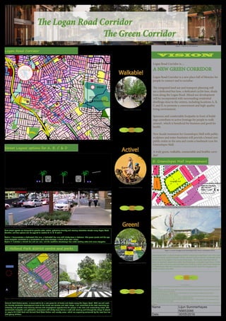
Logan Road Corridor
Legends:
paths
nodes
edges
landmarks
districts / centres
with 400m radius
Origin / Data Source:
Brisbane City Plan 2014
Projection: Map Grid of Australia, Zone 56
Horizontal Datum: Geocentric Datum of Australia
1994
Location Logan Road Corridor between
Stones Corner (Greenslope) and
Marshall Road (Holland Park)
Author Lijun Summerhayes
Date 19/05/2016
N
0 200 400 600M/ 1:10,000@A2
A
B
C A: KFC / IGA MARKET
B: Greenslopes Mall
C: Holland Park District Centre
D: Greenslopes Hospital
E: Stones Corner
D
Shops
or
Centres
Residential
Residential
Residential
Retails / Shops
BUS BUS
3.5 m3 m
1.5m 3.5 m3.5 m3.5 m4.2 m
Median
lane
Car lane Bus laneBus lane Car laneFootpath
4.2 m
FootpathBike Lane
1.5m
Bike Lanecar park
Figure 1: Typical Streetscape along the Logan Road
Council and the copyright owners permit the use of
the data on this map, but the Council and copyright
owners give no warranty in relation to the data
(including accuracy, reliability, completeness,
currency or suitability) and accept no liability (including
without limitation, liability in negligence) for any loss,
damage or costs (including consequential damage),
relating to any use of this data.
Projection: M ap Grid of A ustralia, Zone 56
Horizontal Datum : Geoc entric Datum of A us tralia 1994
NOTE S
BRISBANE CITY
Planning Scheme 1:2,500Approximate Scale @ A4
Copyright Br isbane City Counc il 2015
©
0 90
Metres
Date: 21/05/2016
Brisbane City Plan 2014
Page 1
This m ap is notional only and s hould not be used for
inter pr eting City P lan pr ov isions relating to specific s ites.
To properly inter pr et the m aps , the planning scheme
must be referred to. The Digital Cadastre Databas e
(supplied by State of Queensland - Department of Natural
Resources and M ines) will be updated from time to time.
Mapping adopted by Counc il, effec tive 18 S eptember 2015.
Greenslopes Mall
mixed use
mixeduse
medium
density residential
laitnediserytisnedmuidem
m
edium
density residential
m
edium
density residential
m
edium
densityresidential N
Orginal source: Brisbane City Plan 2014
Author: Lijun Summerhayes
Date: 23 May 2016
0 90m
Scale @ 1: 2,500
Council and the copyright owners permit the use of
the data on this map, but the Council and copyright
owners give no warranty in relation to the data
(including accuracy, reliability, completeness,
currency or suitability) and accept no liability (including
without limitation, liability in negligence) for any loss,
damage or costs (including consequential damage),
relating to any use of this data.
Projection: M ap Grid of A ustralia, Zone 56
Horizontal Datum : Geoc entric Datum of A us tralia 1994
NOTE S
BRISBANE CITY
Planning Scheme 1:5,000Approximate Scale @ A4
Copyright Br isbane City Counc il 2015
©
0 180
Metres
Date: 23/05/2016
Brisbane City Plan 2014
Page 1
This m ap is notional only and s hould not be used for
inter pr eting City P lan pr ov isions relating to specific s ites.
To properly inter pr et the m aps , the planning scheme
must be referred to. The Digital Cadastre Databas e
(supplied by State of Queensland - Department of Natural
Resources and M ines) will be updated from time to time.
Mapping adopted by Counc il, effec tive 18 S eptember 2015.
C B Mott Park
Holland Park State School
Marshall Road
Holland Park Rd
Logan
Road
Crump St
C & K
Dan Murphy
Holland Park Hotel
Medical
Centre
Church
Wj Scott Park
Pedestrian Movement
Active Frontage
Within 180m radius
0 180m
Scale @ 1: 5,000
shops/m
ixed
use
shops/m
ixed
use
shops/m
ixed
use
shops/m
ixed
use
Orginal source: Brisbane City Plan 2014
Author: Lijun Summerhayes
Date: 23 May 2016
N
mixed use / shops / retail
low-medium
residential
low-m
edium
residential
low-medium
residential
low-medium
residential
low-medium
residential
Figure 7: Active frontage in the Holland Park District Centre area, including C B Mott Park
Figure 1: Mixed Use Development
Figure 6: Active frontage in the Greenslopes Mall. Source: CGarchitect (2013)
Figure 5: Street Design option 2
Figure 3: Street Design option 1
Figure 10: Colville-Andersen (2010)
Figure 9: Shahan, A (2014)
Figure 8: Gehl Arhcitects (2011)
Figure 11: Melbourne City Council (2013)
Figure 2: Logan Road Corridor
Figure 4: Active frontage around Greenslopes Mall, with mixed use development nearby
Name Lijun Summerhayes
N9653066
Date 30/05/2016
List of References:
Figure 1: CGArchitect (2016). Mixed use development. Retrieved from http://www.cgarchitect.com/2016/05/mixed-develop-
ment-project
Figure 6: CGarchitect (2013). Plaza Design with Fountains and canopies. Retrieved from http://www.cgarchitect.com/2013/11/
plaza-design-with-fountains-and-canopies
Figure 8: Gehl Arhcitects (2011). Flying Pigeon LA. Retrieved May 26, 2016 from https://gehlarchitects.wordpress.
com/2011/01/27/gehl-architects-in-los-angeles/
Figure 9: Shahan, A. (2014). Preserve your brain, live in a walkable neighbourhood. Retrieved from http://www.treehugger.
com/urban-design/preserve-your-brain-live-walkable-neighborhood.html
Figure 10: Colville-Andersen (2010). Copenhagen Bicycle Against Yellow Wall 11. Retrieved May 26, 2016 fromhttps://www.
flickr.com/photos/16nine/4895153388/
Figure 11: Melbourne City Council (2013). St Kilda Southbound danger. Retrieved from http://melbcity.net.au/category/bicy-
cle-lanes/
Active!
Walkable!
Green!
Holland Park district centre, is visualised to be a new place full of hustle and bustle along the Logan Road. With low and medi-
um density residential development close to the mixed use centres and retail shops, it will contribute to the local economy sig-
nificantly and provide more housing choices and employment opportunities for people in the local and surrounding areas. The
comfortable footpaths and pedestrian crossovers with shady trees deliver a safe and relaxing walk through the shops & extend
all way to C B Mott Park and Holland Park State School and nearby areas, which are especially welcomed by the local families
with young children.
New street layouts are designed to provide safer, active, pedestrian friendly and socially interactive streets along Logan Road
Corridor, and two options can be applied to location A, B, C, D and E.
Option 1 demonstrates a dedicated bike lane, a dedicated bus lane with shady trees in between. The green plants and the spa-
cious footpaths contribute to a comfortable and active frontage in front of the retail shops.
Option 2 illustrates a shared bus and car lane, and the aesthetic streetscape has made walking safer and more enjoyable
Greenslopes Mall, a robust shopping centre, is playing a significant role in the local
and surrounding neighbourhoods. Mixed use and medium density residential devel-
opment are encouraged in the surrounding areas. The façade treatment will en-
hance its aesthetic appeal and make the shopping an enjoyable experience. Public
sculpture with numerous water fountains are creating a brand new iconic landmark
for Greenslopes Mall and providing a welcoming public realm for shoppers and
families to enjoy and relax.
Social Connectivity
Social Connectivity
Social Connectivity
Social Connectivity
Logan Road Corridor is.....
A NEW GREEN CORRIDOR
Logan Road Corridor is a new place full of lifestyles for
people to connect and to socialise.
The integrated land use and transport planning will
see a dedicated bus lane, a dedicated cyclist lane, shady
trees along the Logan Road. Mixed use development
will be incorporated with surrounding residential
dwellings close to the centres, including locations A, B,
C and D, to promote a conveninent and high-quality
living environment.
Spaceous and comfortable footpaths in front of build-
ings contribute to active frontage for people to walk
around , which is beneficial for business and good for
health.
New facade treatment for Greenslopes Mall with public
sculpture and water fountains will provide a brand new
public realm in the area and create a landmark icon for
Greenslopes Mall.
A truly green, walkable, connectable and healthy corri-
dor!
B: Greenslopes Mall Improvement
VISION
C: Holland Park district centre and parks
Street Layout Option 1
Street Layout Option 2
Street Layout options for A, B, C & D
Logan Road Corridor