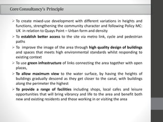
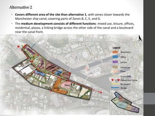
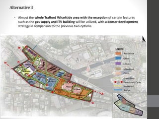
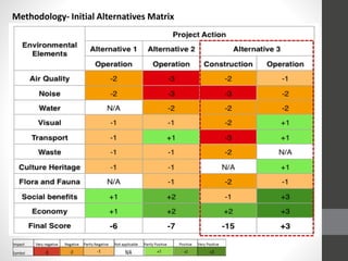
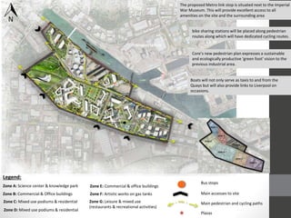
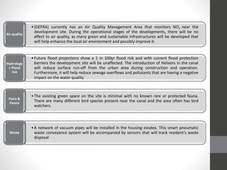
SlideShare a Scribd company logo
1 of 29
SALFORD QUAYS DEVELOPMENT
Core Consultancy
Structure
•Location
•History
•Land Use Map
•Opportunities and constraints
•Alternatives
•Methodology
•Master Plan
LOCATION
HISTORY
ManchesterDryDocksduringthe
IndustrialRevolutionandtoday
Then Now
Land Use Map
DRY DOCKS ENERGY INFRASTRUCTURE
LEISURE RETAIL
TRANSPORT DESIGN
ENVIRONMENTAL
OPPORTUNITIES CONSTRAINTS
Manchester Ship Canal
(cultural)
Manchester Ship Canal
(physical)
Strategic location
(social and economic)
Energy Infrastructure
(visual)
Ecology Park
(environmental)
Limited access
(transport)
POLICIES
• National Planning Policy Framework (2012)
• Trafford Local Plan (2012)
• Mediacity UK and Quays Point Planning Guidance (2013)
Development Alternatives
CoreConsultancy’s Principle
 To create mixed-use development with different variations in heights and
functions, strengthening the community character and following Policy MC:
UK in relation to Quays Point – Urban form and density
 To establish better access to the site via metro link, cycle and pedestrian
paths
 To improve the image of the area through high quality design of buildings
and spaces that meets high environmental standards whilst responding to
existing context
 To use green infrastructure of links connecting the area together with open
plazas,
 To allow maximum view to the water surface, by having the heights of
buildings gradually descend as they get closer to the canal, with buildings
along the perimeter the highest
 To provide a range of facilities including shops, local cafes and leisure
opportunities that will bring vibrancy and life to the area and benefit both
new and existing residents and those working in or visiting the area
Trafford Wharfside main Zones for development
• Different planning options for the Trafford Wharfside area were formulated
according to the Salford City Council & Trafford metropolitan Borough Council
Planning Guidance and Trafford Local Plan. The options evaluated were hence:
Alternative1
• Comprises of low-development scheme of the area (in terms of urban density) with
residential housing, offices, scientific park and leisure activities.
• Some zones are left undeveloped retaining their current functions such as the
industrial businesses in zone C and zones E, F & G near the Ship Canal.
Residence
Legend
Office
Leisure
Science Park
Plaza
Green links
Pedestrian/ Cycle
Justification:
• In the first alternative, the scheme tries to respect the neighbouring
context in terms of height and massing but still economically benefit
from the development.
• Further more, zones E, F & G are left undeveloped to retain their
important functions of supplying gas and the satellite dishes.
Alternative2
• Covers different area of the site than alternative 1, with zones closer towards the
Manchester ship canal, covering parts of Zones B, C, E, and G.
• The medium development consists of different functions: mixed use, leisure, offices,
residential, plazas, a linking bridge across the other side of the canal and a boulevard
near the canal front.
Residence
Legend
Office
Leisure
Mixed-use
Plaza
Green links
Pedestrian/ Cycle
Boulevard
Bridge
Justification:
• Functions such as the boulevard will act as an attraction spot,
reviving the area but the existence of the neighbouring gas tanks,
would obstruct the extension of the boulevard limiting its length and
the noisy trucks accessing the area (zone F)
• The pedestrian bridge, following the recommendation in TP5 policy
(Salford City Council & Trafford metropolitan Borough Council
Planning Guidance) ‘the construction of a new footbridge, linking
Quays Point with Trafford Wharfside’.
Alternative3
• Almost the whole Trafford Wharfside area with the exception of certain features
such as the gas supply and ITV building will be utilized, with a denser development
strategy in comparison to the previous two options.
Residence
Legend
Office
Leisure
Mixed-use
Plaza
Green links
Pedestrian/ Cycle
Boulevard
Bridge
Justification:
• Different functions radiate from the ship canal covering the area
with offices, mixed-use including hotel apartments, residential
consisting of 1,2,& 3 bedroom apartments (following CS Policy SL2),
leisure activities and innovation park with the scientific building to
strengthen the neighbouring ecological park attracting tourist and
community visits creating an educational hub.
• The integration of sustainable features and mechanisms in the
buildings such as green roofs, Solar panels, etc. to reduce the
negative impacts of the development as much as possible.
Methodology- Initial Alternatives Matrix
Dry Docks District Master plan
Coreconsultancy’sDryDocksDistrictMasterPlanvision:
“Aplacewherepeoplechoosetolive,work,relaxandenjoy”
(Sustainableintegratedcommunitystrategy)
 The master plan has been developed from the alternatives matrix
described in the previous section. It has been refined and
developed to match the needs and standards of the landowner:
Peel Holdings and Trafford Council.
 The development spreads throughout the whole site from zones A to
G on an area of approximately 62 ha. Ranges of facilities are
contained in the area consisting of: mixed use, residential,
commercial, office buildings, a science centre , innovation park ,
and leisure amenities.
Dry Docks District MASTER PLAN
Land use
Legend:
Residential & mixed use Commercial & office buildings Science center Leisure
★
★
★
★
★
★
★
Boats will not only serve as taxis to and from the
Quays but will also provide links to Liverpool on
occasions.
The proposed Metro link stop is situated next to the Imperial
War Museum. This will provide excellent access to all
amenities on the site and the surrounding area
Core’s new pedestrian plan expresses a sustainable
and ecologically productive ‘green foot’ vision to the
previous industrial area.
bike sharing stations will be placed along pedestrian
routes along which will have dedicated cycling routes.
Legend:
Bus stops
Main accesses to site
Main pedestrian and cycling paths
Zone A: Science center & knowledge park
Zone B: Commercial & Office buildings
Zone C: Mixed use podiums & residential
Zone D: Mixed use podiums & residential
Zone E: Commercial & office buildings
Zone F: Artistic works on gas tanks
Zone G: Leisure & mixed use
(restaurants & recreational activities)
★ Plazas
Transportation
★
★
★★
★
★
★
Site features:
1. Boulevard development towards
waterfront + a connection bridge;
2. Painted gas tanks, aesthetically
appealing;
3. Maximized views of offices towards
canal;
4. Taxi boats;
5. Innovative Science center + innovation
park;
6. Plazas for a pleasant breathing space;
7. Connecting bridges in semi public
spaces between buildings.
1 2 3 4
5 6 7
bio-adaptive façade of micro algae
The proposed developments will be in character with the existing infrastructure across the canal in accordance with
MediaCityUKandflushwithITVandtheImperialWarMuseum.Theywillimprovetheurbanfabricoftheareadominating
the skyline of the city creating a remarkable and iconic silhouette.
Roof garden
Green Walls
Geothermal Heating
Rain water harvesting + storage trees
Native trees + Landscaping
Smart & Sustainable urban design
Transportation
•(DEFRA) currently has an Air Quality Management Area that monitors NO2 near the
development site. During the operational stages of the developments, there will be no
affect to air quality, as many green and sustainable infrastructures will be developed that
will help enhance the local air environment and possibly improve it.
Air quality
•Future flood projections show a 1 in 100yr flood risk and with current flood protection
barriers the development site will be unaffected. The introduction of Helixors in the canal
will reduce surface run-off from the urban area during construction and operation.
Furthermore, it will help reduce sewage overflows and pollutants that are having a negative
impact on the water quality
Hydrology
+ Flood
risk
•The existing green space on the site is minimal with no known rare or protected fauna.
There are many different bird species present near the canal and the area often has bird
watchers.
Flora &
Fauna
•A network of vacuum pipes will be installed in the housing estates. This smart pneumatic
waste conveyance system will be accompanied by sensors that will track resident’s waste
disposal
Waste
Strengths
- Highly innovative
sustainable features
integrated in the
urban design.
- Connected buildings
strengthens the
urban fabric.
- Increased economic
benefits.
- Existing public
transport network.
- Strong accesses to
site (streets, cycling
paths, walkways, taxi
boats, and bridges.
- Helixors reduces
surface runoffs.
- Smart waste
disposal vacuum
pipes in residential
units increases
disposal efficiency.
Weakness
- Limited+ disturbed
boulevard path
towards waterfront.
- Site congestion.
- Increases in car
usage in site could
increase air pollution.
- Vague policies for
the area, with
different guidance.
Opportunities
- Taxi boats increases
site visitors.
- Visually appealing
gas tanks.
- Integrated design
approach increasing
workers satisfaction
& productivity.
-Social & Integrated
community approach
increasing residents
satisfaction &
demand
- Jobs & education
- Maximizing the
potential of the canal
as a key physical
asset.
- Connection to the
ecological park.
Threats
- The disturbance of
birds in site during
construction could
lead to their
migration from the
site.
- Increase in crime
rates.
- Poor conditions of
neighboring sites.
S W O T

More Related Content

What's hot

Urban Design Studio PPT
Urban Design Studio PPTUrban Design Studio PPT
Urban Design Studio PPTAngela Jaffuel
 
Item 7.4 public use facility design ordinance
Item 7.4 public use facility design ordinanceItem 7.4 public use facility design ordinance
Item 7.4 public use facility design ordinanceepdevelopment
 
Nicholas DiFrank - Professional Portfolio 2015
Nicholas DiFrank - Professional Portfolio 2015Nicholas DiFrank - Professional Portfolio 2015
Nicholas DiFrank - Professional Portfolio 2015Nicholas DiFrank
 
PDR Housing estate renewal capability.FINAL[1]
PDR Housing estate renewal capability.FINAL[1]PDR Housing estate renewal capability.FINAL[1]
PDR Housing estate renewal capability.FINAL[1]Michael Walton
 
Central-East Open House - Laird Station to West At-Grade (Sunnybrook - O'Conn...
Central-East Open House - Laird Station to West At-Grade (Sunnybrook - O'Conn...Central-East Open House - Laird Station to West At-Grade (Sunnybrook - O'Conn...
Central-East Open House - Laird Station to West At-Grade (Sunnybrook - O'Conn...Crosstown TO
 
Kane County 529 PACE Route Study Presentation 2010
Kane County 529 PACE Route Study Presentation 2010Kane County 529 PACE Route Study Presentation 2010
Kane County 529 PACE Route Study Presentation 2010City of Geneva
 
Cts tradeshow remarks
Cts tradeshow remarksCts tradeshow remarks
Cts tradeshow remarksCrosstown TO
 
Irsdc layout planning + form based code presentation RAILOPOLIS
Irsdc layout planning + form based code presentation RAILOPOLISIrsdc layout planning + form based code presentation RAILOPOLIS
Irsdc layout planning + form based code presentation RAILOPOLISTOD India
 
New Street Typologies/New Street Types - Getting more out of the same R.O.W.:...
New Street Typologies/New Street Types - Getting more out of the same R.O.W.:...New Street Typologies/New Street Types - Getting more out of the same R.O.W.:...
New Street Typologies/New Street Types - Getting more out of the same R.O.W.:...Congress for the New Urbanism
 
FCDOT: Rolling Road Widening from Fullerton Road to Delong Drive-Apr.19, 2012
FCDOT: Rolling Road Widening from Fullerton Road to Delong Drive-Apr.19, 2012FCDOT: Rolling Road Widening from Fullerton Road to Delong Drive-Apr.19, 2012
FCDOT: Rolling Road Widening from Fullerton Road to Delong Drive-Apr.19, 2012Fairfax County
 
DTN/EL Park District Presentation to City Council on 12/10/13
DTN/EL Park District Presentation to City Council on 12/10/13DTN/EL Park District Presentation to City Council on 12/10/13
DTN/EL Park District Presentation to City Council on 12/10/13Joe Manzella
 
Uptown Streetscape Concept Plan
Uptown Streetscape Concept PlanUptown Streetscape Concept Plan
Uptown Streetscape Concept Planyucaipa
 

What's hot (20)

Section 2 Inventory and Assessment
Section 2  Inventory and AssessmentSection 2  Inventory and Assessment
Section 2 Inventory and Assessment
 
Urban Design Studio PPT
Urban Design Studio PPTUrban Design Studio PPT
Urban Design Studio PPT
 
University Town Center Rezoning
University Town Center RezoningUniversity Town Center Rezoning
University Town Center Rezoning
 
Item 7.4 public use facility design ordinance
Item 7.4 public use facility design ordinanceItem 7.4 public use facility design ordinance
Item 7.4 public use facility design ordinance
 
Nicholas DiFrank - Professional Portfolio 2015
Nicholas DiFrank - Professional Portfolio 2015Nicholas DiFrank - Professional Portfolio 2015
Nicholas DiFrank - Professional Portfolio 2015
 
Shops at University Town Center
Shops at University Town CenterShops at University Town Center
Shops at University Town Center
 
City Hall Site Selection
City Hall Site SelectionCity Hall Site Selection
City Hall Site Selection
 
PDR Housing estate renewal capability.FINAL[1]
PDR Housing estate renewal capability.FINAL[1]PDR Housing estate renewal capability.FINAL[1]
PDR Housing estate renewal capability.FINAL[1]
 
Central-East Open House - Laird Station to West At-Grade (Sunnybrook - O'Conn...
Central-East Open House - Laird Station to West At-Grade (Sunnybrook - O'Conn...Central-East Open House - Laird Station to West At-Grade (Sunnybrook - O'Conn...
Central-East Open House - Laird Station to West At-Grade (Sunnybrook - O'Conn...
 
Kane County 529 PACE Route Study Presentation 2010
Kane County 529 PACE Route Study Presentation 2010Kane County 529 PACE Route Study Presentation 2010
Kane County 529 PACE Route Study Presentation 2010
 
Cts tradeshow remarks
Cts tradeshow remarksCts tradeshow remarks
Cts tradeshow remarks
 
NZC - Hendee
NZC - HendeeNZC - Hendee
NZC - Hendee
 
Transit Ready Design - Canin CNU17
Transit Ready Design - Canin CNU17Transit Ready Design - Canin CNU17
Transit Ready Design - Canin CNU17
 
Final Boards
Final BoardsFinal Boards
Final Boards
 
Irsdc layout planning + form based code presentation RAILOPOLIS
Irsdc layout planning + form based code presentation RAILOPOLISIrsdc layout planning + form based code presentation RAILOPOLIS
Irsdc layout planning + form based code presentation RAILOPOLIS
 
New Street Typologies/New Street Types - Getting more out of the same R.O.W.:...
New Street Typologies/New Street Types - Getting more out of the same R.O.W.:...New Street Typologies/New Street Types - Getting more out of the same R.O.W.:...
New Street Typologies/New Street Types - Getting more out of the same R.O.W.:...
 
Six Points Reconfiguration - Community Update June, 2013
Six Points Reconfiguration - Community Update June, 2013Six Points Reconfiguration - Community Update June, 2013
Six Points Reconfiguration - Community Update June, 2013
 
FCDOT: Rolling Road Widening from Fullerton Road to Delong Drive-Apr.19, 2012
FCDOT: Rolling Road Widening from Fullerton Road to Delong Drive-Apr.19, 2012FCDOT: Rolling Road Widening from Fullerton Road to Delong Drive-Apr.19, 2012
FCDOT: Rolling Road Widening from Fullerton Road to Delong Drive-Apr.19, 2012
 
DTN/EL Park District Presentation to City Council on 12/10/13
DTN/EL Park District Presentation to City Council on 12/10/13DTN/EL Park District Presentation to City Council on 12/10/13
DTN/EL Park District Presentation to City Council on 12/10/13
 
Uptown Streetscape Concept Plan
Uptown Streetscape Concept PlanUptown Streetscape Concept Plan
Uptown Streetscape Concept Plan
 

Similar to EIA Project - Presentation

Strategic plan poster final
Strategic plan poster finalStrategic plan poster final
Strategic plan poster finalVanessa Baratta
 
Toufic jreije portfolio
Toufic jreije portfolioToufic jreije portfolio
Toufic jreije portfoliotkjreije
 
Advancing Sustainability in Discretionary Review 2
Advancing Sustainability in Discretionary Review 2Advancing Sustainability in Discretionary Review 2
Advancing Sustainability in Discretionary Review 2Wallace Roberts & Todd
 
Milpitas redevelopment case study,
Milpitas redevelopment case study, Milpitas redevelopment case study,
Milpitas redevelopment case study, Ar Pankaj Kumar
 
PPPF222.pptx
PPPF222.pptxPPPF222.pptx
PPPF222.pptxBossGold
 
Brownfield project by Shrikant
Brownfield project  by ShrikantBrownfield project  by Shrikant
Brownfield project by ShrikantShriKant49
 
Informal notes from Urban Planning 3_13-14 (1).pdf
Informal notes from Urban Planning 3_13-14 (1).pdfInformal notes from Urban Planning 3_13-14 (1).pdf
Informal notes from Urban Planning 3_13-14 (1).pdfkayfiakrmmawlan
 
appendix A1 -Pedestrian Plan_201402051129059977
appendix A1 -Pedestrian Plan_201402051129059977appendix A1 -Pedestrian Plan_201402051129059977
appendix A1 -Pedestrian Plan_201402051129059977Carson Quam
 
Urban Design Portfolio Tim Hays
Urban Design Portfolio Tim HaysUrban Design Portfolio Tim Hays
Urban Design Portfolio Tim HaysTim Hays
 
Flacq Profile
Flacq ProfileFlacq Profile
Flacq Profilejames.f
 
SY_Yao_Portfolio0615
SY_Yao_Portfolio0615SY_Yao_Portfolio0615
SY_Yao_Portfolio0615Yao Shi-Yuan
 
Construction Choreography
Construction ChoreographyConstruction Choreography
Construction ChoreographyMichael Fishman
 
Trial for online
Trial for onlineTrial for online
Trial for onlineelogilvie
 
I concept design presentation - expooilgas
I concept design presentation - expooilgasI concept design presentation - expooilgas
I concept design presentation - expooilgaspegasgroupfzc
 
Ogilvie ldn 1 12 pt text t5
Ogilvie ldn 1 12 pt text t5Ogilvie ldn 1 12 pt text t5
Ogilvie ldn 1 12 pt text t5elogilvie
 

Similar to EIA Project - Presentation (20)

Strategic plan poster final
Strategic plan poster finalStrategic plan poster final
Strategic plan poster final
 
Toufic jreije portfolio
Toufic jreije portfolioToufic jreije portfolio
Toufic jreije portfolio
 
Advancing Sustainability in Discretionary Review 2
Advancing Sustainability in Discretionary Review 2Advancing Sustainability in Discretionary Review 2
Advancing Sustainability in Discretionary Review 2
 
Matrix
MatrixMatrix
Matrix
 
Milpitas redevelopment case study,
Milpitas redevelopment case study, Milpitas redevelopment case study,
Milpitas redevelopment case study,
 
PPPF222.pptx
PPPF222.pptxPPPF222.pptx
PPPF222.pptx
 
Brownfield project by Shrikant
Brownfield project  by ShrikantBrownfield project  by Shrikant
Brownfield project by Shrikant
 
Informal notes from Urban Planning 3_13-14 (1).pdf
Informal notes from Urban Planning 3_13-14 (1).pdfInformal notes from Urban Planning 3_13-14 (1).pdf
Informal notes from Urban Planning 3_13-14 (1).pdf
 
appendix A1 -Pedestrian Plan_201402051129059977
appendix A1 -Pedestrian Plan_201402051129059977appendix A1 -Pedestrian Plan_201402051129059977
appendix A1 -Pedestrian Plan_201402051129059977
 
Urban Design Portfolio Tim Hays
Urban Design Portfolio Tim HaysUrban Design Portfolio Tim Hays
Urban Design Portfolio Tim Hays
 
Flacq Profile
Flacq ProfileFlacq Profile
Flacq Profile
 
Marina Yacht Club at Lusail, Qatar
Marina Yacht Club at Lusail, QatarMarina Yacht Club at Lusail, Qatar
Marina Yacht Club at Lusail, Qatar
 
SY_Yao_Portfolio0615
SY_Yao_Portfolio0615SY_Yao_Portfolio0615
SY_Yao_Portfolio0615
 
Construction Choreography
Construction ChoreographyConstruction Choreography
Construction Choreography
 
Final report
Final reportFinal report
Final report
 
URBAN DESIGN BOOK COMPENDIUM 1-2 (creating the the urban structure)
URBAN DESIGN BOOK COMPENDIUM 1-2 (creating the the urban structure)URBAN DESIGN BOOK COMPENDIUM 1-2 (creating the the urban structure)
URBAN DESIGN BOOK COMPENDIUM 1-2 (creating the the urban structure)
 
Trial for online
Trial for onlineTrial for online
Trial for online
 
I concept design presentation - expooilgas
I concept design presentation - expooilgasI concept design presentation - expooilgas
I concept design presentation - expooilgas
 
Ogilvie ldn 1 12 pt text t5
Ogilvie ldn 1 12 pt text t5Ogilvie ldn 1 12 pt text t5
Ogilvie ldn 1 12 pt text t5
 
Eu best practices
Eu best practicesEu best practices
Eu best practices
 

EIA Project - Presentation

  • 2. Structure •Location •History •Land Use Map •Opportunities and constraints •Alternatives •Methodology •Master Plan
  • 6. DRY DOCKS ENERGY INFRASTRUCTURE
  • 10. OPPORTUNITIES CONSTRAINTS Manchester Ship Canal (cultural) Manchester Ship Canal (physical) Strategic location (social and economic) Energy Infrastructure (visual) Ecology Park (environmental) Limited access (transport)
  • 11. POLICIES • National Planning Policy Framework (2012) • Trafford Local Plan (2012) • Mediacity UK and Quays Point Planning Guidance (2013)
  • 13. CoreConsultancy’s Principle  To create mixed-use development with different variations in heights and functions, strengthening the community character and following Policy MC: UK in relation to Quays Point – Urban form and density  To establish better access to the site via metro link, cycle and pedestrian paths  To improve the image of the area through high quality design of buildings and spaces that meets high environmental standards whilst responding to existing context  To use green infrastructure of links connecting the area together with open plazas,  To allow maximum view to the water surface, by having the heights of buildings gradually descend as they get closer to the canal, with buildings along the perimeter the highest  To provide a range of facilities including shops, local cafes and leisure opportunities that will bring vibrancy and life to the area and benefit both new and existing residents and those working in or visiting the area
  • 14. Trafford Wharfside main Zones for development • Different planning options for the Trafford Wharfside area were formulated according to the Salford City Council & Trafford metropolitan Borough Council Planning Guidance and Trafford Local Plan. The options evaluated were hence:
  • 15. Alternative1 • Comprises of low-development scheme of the area (in terms of urban density) with residential housing, offices, scientific park and leisure activities. • Some zones are left undeveloped retaining their current functions such as the industrial businesses in zone C and zones E, F & G near the Ship Canal. Residence Legend Office Leisure Science Park Plaza Green links Pedestrian/ Cycle
  • 16. Justification: • In the first alternative, the scheme tries to respect the neighbouring context in terms of height and massing but still economically benefit from the development. • Further more, zones E, F & G are left undeveloped to retain their important functions of supplying gas and the satellite dishes.
  • 17. Alternative2 • Covers different area of the site than alternative 1, with zones closer towards the Manchester ship canal, covering parts of Zones B, C, E, and G. • The medium development consists of different functions: mixed use, leisure, offices, residential, plazas, a linking bridge across the other side of the canal and a boulevard near the canal front. Residence Legend Office Leisure Mixed-use Plaza Green links Pedestrian/ Cycle Boulevard Bridge
  • 18. Justification: • Functions such as the boulevard will act as an attraction spot, reviving the area but the existence of the neighbouring gas tanks, would obstruct the extension of the boulevard limiting its length and the noisy trucks accessing the area (zone F) • The pedestrian bridge, following the recommendation in TP5 policy (Salford City Council & Trafford metropolitan Borough Council Planning Guidance) ‘the construction of a new footbridge, linking Quays Point with Trafford Wharfside’.
  • 19. Alternative3 • Almost the whole Trafford Wharfside area with the exception of certain features such as the gas supply and ITV building will be utilized, with a denser development strategy in comparison to the previous two options. Residence Legend Office Leisure Mixed-use Plaza Green links Pedestrian/ Cycle Boulevard Bridge
  • 20. Justification: • Different functions radiate from the ship canal covering the area with offices, mixed-use including hotel apartments, residential consisting of 1,2,& 3 bedroom apartments (following CS Policy SL2), leisure activities and innovation park with the scientific building to strengthen the neighbouring ecological park attracting tourist and community visits creating an educational hub. • The integration of sustainable features and mechanisms in the buildings such as green roofs, Solar panels, etc. to reduce the negative impacts of the development as much as possible.
  • 22. Dry Docks District Master plan
  • 23. Coreconsultancy’sDryDocksDistrictMasterPlanvision: “Aplacewherepeoplechoosetolive,work,relaxandenjoy” (Sustainableintegratedcommunitystrategy)  The master plan has been developed from the alternatives matrix described in the previous section. It has been refined and developed to match the needs and standards of the landowner: Peel Holdings and Trafford Council.  The development spreads throughout the whole site from zones A to G on an area of approximately 62 ha. Ranges of facilities are contained in the area consisting of: mixed use, residential, commercial, office buildings, a science centre , innovation park , and leisure amenities.
  • 24. Dry Docks District MASTER PLAN Land use Legend: Residential & mixed use Commercial & office buildings Science center Leisure
  • 25. ★ ★ ★ ★ ★ ★ ★ Boats will not only serve as taxis to and from the Quays but will also provide links to Liverpool on occasions. The proposed Metro link stop is situated next to the Imperial War Museum. This will provide excellent access to all amenities on the site and the surrounding area Core’s new pedestrian plan expresses a sustainable and ecologically productive ‘green foot’ vision to the previous industrial area. bike sharing stations will be placed along pedestrian routes along which will have dedicated cycling routes. Legend: Bus stops Main accesses to site Main pedestrian and cycling paths Zone A: Science center & knowledge park Zone B: Commercial & Office buildings Zone C: Mixed use podiums & residential Zone D: Mixed use podiums & residential Zone E: Commercial & office buildings Zone F: Artistic works on gas tanks Zone G: Leisure & mixed use (restaurants & recreational activities) ★ Plazas Transportation
  • 26. ★ ★ ★★ ★ ★ ★ Site features: 1. Boulevard development towards waterfront + a connection bridge; 2. Painted gas tanks, aesthetically appealing; 3. Maximized views of offices towards canal; 4. Taxi boats; 5. Innovative Science center + innovation park; 6. Plazas for a pleasant breathing space; 7. Connecting bridges in semi public spaces between buildings. 1 2 3 4 5 6 7
  • 27. bio-adaptive façade of micro algae The proposed developments will be in character with the existing infrastructure across the canal in accordance with MediaCityUKandflushwithITVandtheImperialWarMuseum.Theywillimprovetheurbanfabricoftheareadominating the skyline of the city creating a remarkable and iconic silhouette. Roof garden Green Walls Geothermal Heating Rain water harvesting + storage trees Native trees + Landscaping Smart & Sustainable urban design
  • 28. Transportation •(DEFRA) currently has an Air Quality Management Area that monitors NO2 near the development site. During the operational stages of the developments, there will be no affect to air quality, as many green and sustainable infrastructures will be developed that will help enhance the local air environment and possibly improve it. Air quality •Future flood projections show a 1 in 100yr flood risk and with current flood protection barriers the development site will be unaffected. The introduction of Helixors in the canal will reduce surface run-off from the urban area during construction and operation. Furthermore, it will help reduce sewage overflows and pollutants that are having a negative impact on the water quality Hydrology + Flood risk •The existing green space on the site is minimal with no known rare or protected fauna. There are many different bird species present near the canal and the area often has bird watchers. Flora & Fauna •A network of vacuum pipes will be installed in the housing estates. This smart pneumatic waste conveyance system will be accompanied by sensors that will track resident’s waste disposal Waste
  • 29. Strengths - Highly innovative sustainable features integrated in the urban design. - Connected buildings strengthens the urban fabric. - Increased economic benefits. - Existing public transport network. - Strong accesses to site (streets, cycling paths, walkways, taxi boats, and bridges. - Helixors reduces surface runoffs. - Smart waste disposal vacuum pipes in residential units increases disposal efficiency. Weakness - Limited+ disturbed boulevard path towards waterfront. - Site congestion. - Increases in car usage in site could increase air pollution. - Vague policies for the area, with different guidance. Opportunities - Taxi boats increases site visitors. - Visually appealing gas tanks. - Integrated design approach increasing workers satisfaction & productivity. -Social & Integrated community approach increasing residents satisfaction & demand - Jobs & education - Maximizing the potential of the canal as a key physical asset. - Connection to the ecological park. Threats - The disturbance of birds in site during construction could lead to their migration from the site. - Increase in crime rates. - Poor conditions of neighboring sites. S W O T