
Recommended
More Related Content
What's hot
What's hot (20)
Similar to Binder1
Similar to Binder1 (20)
Recently uploaded
Recently uploaded (20)
Binder1
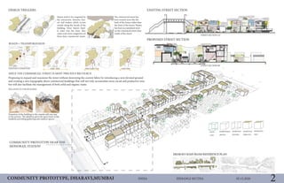
- 1. 05.15.2020HIMANGI MUTHAINDIACOMMUNITY PROTOTYPE, DHARAVI,MUMBAI 2 Proposing to expand and maximize the street without destroying the current fabric by introducing a new elevated ground and creating a new topography above commercial buildings that will not only accomodate more social and productive area but will also facilitate the management of both solid and organic waste. Extantion of the building to the outside add one step to the privacy. The platform gives the space back to the residents providing gathering and outdoor spaces. DESIGN TRIGGERS EXISTING STREET SECTION PROPOSED STREET SECTION COMMUNITY PROTOTYPE NEAR THE MONORAIL STATION ROADS + TRANSPORATAION SINCE THE COMMERCIAL STREET IS MOST PRECIOUS RECOURCE Streets tend to be congested by the interaction between buy- ers and traders which occurs mostly along the facade of the building. Since buyers hard- ly enter into the store, they cause even more congestion on these busy commercial streets. The commercial street has been treated more like the back of the house rather than the front of the house. Waster has been accumulated more on the commecial street than inside of the chawl. EXISTING CONDITION RELATION TO THE BUILDING STREET SECTION AA’ STREET SECTION BB’ road >15m 10m<road<15m road<10m 3.5m 4m 4m 3.5m
- 2. 05.15.2020HIMANGI MUTHAINDIACOMMUNITY PROTOTYPE, DHARAVI,MUMBAI COMMUNITY DETAILED PLAN SOUTH SECTIONAL EVELATION NORTH SECTIONAL EVELATION COMMUNITY PROTOTYPE AND PROPOSED NEW DHARAVI SITE PLAN (60FT RAOD AND DHARAVI MAIN ROAD) MODULE CREATION BETWEEN ALLEYWAYS PARASITIC STRUC- TURE HEIGHT VARI- ATION ABOVE EACH MODULE COMMUNITY CREATION BETWEEN THE STREETS VIEW OF COMMUNITY PROTOTYPE AND PROPOSED ROOF DETAILS/ ACTIVITIES. Proposed roof activities Surface plantation Surface plantation Elevated ground 1. NEW POROUS GROUND ABOVE THE COM- MERCIAL BUIDLINGS. 2. RENEVUE FROM THE NEW COMMERCIAL AND RESIDENTIAL UNITS ABOVE THE COM- MECIAL BUILDINGS. 3. NEW STREET- COMMUNITY AND PRO- POSED TRADING SYSTEM OF GOODS. 4. STREET DESIGN FOR DEDICALED ACTIVI- TIES. 5. NEW BRIDGES, RAMPS AND STAIRCASES. To achieve the new topography, new grounds were proposed incrementally. The inter- vention will be developed by the commercial and residential owners along the street. Residents will come together as a community to finance this new infrastructure that will provide them with permanent access to clear trading throughout the year and sence of place, while a portion of infrastructure will provide a base for new residential or com- mercial units which could generate revenue by renting out these units. The revenue gen- erated will eventually help to pay back the initial investment. In addition to these private benefits, Dharavi as a whole could gradually benefit from the new proposed community prototype for smoother functioning of the thier businesses and greatly improve the problems existing along the commercial street and these new surfaces would also become grounds for the expansion of Dharavi’s productive, social and economic activities. COOPERATIVE BENEFITS 3
- 3. Allen Central Business District | Catalyst Development Plan L. Catherine Osborn 2020.05.15 Master Plan Catalyst Development Trail-Oriented Development Allen Public Library with Shared Parking Amplitheater Commercial Streetscape Existing Buildings Library with Shared Parking Garage Amplitheater Trail-Oriented Development Farmers Market/ Vendor’s Plaza Adjacent to Histroic District Retaining Existing Trees to Facilitate Trail Connection Catalyst Streetscape Images Source: Google Image AB C D E F G G E H H Mixed Commercial and Apartment Residential High-Density Apartment Townhomes (Attached Single Family) Parking Garage Proposed Development E H E A B C D E F G H
- 4. The proposed street design is more inclusive of all modes of transportation. It provides both the safety and accessibility that was largely missing from the previous configuration. [3] South Drive Revival Project 16-ft Rachel Jenkins - PLAN 5333 - Graphics & Media Communication - 5/15/2020
- 5. Ricqui Brager PLAN 5333 Final Project- Page 1 May 15, 2020 I30: All Hands On Deck I-30 was constructed in the 1960’s and cityMap, a project with support from TxDOT, located scenarios of changing how the highways go through the city, one of which in east Dallas near Fair Park. One scenario is lowering portions of I-30 to run below frontage roads as opposed to their current state above. A deck park could be incorporated into the available space and create more connections from Fair Park to Deep Ellum. Fair Park is historical and much history resides on this site and in the surrounding neighborhoods. Sitting idle a majority of the year, more pedestrian friendly options and walkable open space will allow the community to easily connect more often between the two. It is interesting to note that some refer to I-30 as a barrier, while others consider I-30 as protective. I30: All Hands On Deck Fair Park Deep Ellum
- 6. CentrePort/ DFW Airport StationCentrePort/ DFW Airport Station Graphics and Multimedia Communication Final Assignment Saee More 15th May 2020 Transit-Oriented Development with Smart and Sustainable Growth PoliciesTransit-Oriented Development with Smart and Sustainable Growth Policies Proposed Vision 1/2 Miles TOD Site Opportunities 30 acres Design Strategy 1 Mixed-used Development Park, Recreation open space Station Improvement Pedestrian Bridge Gateways , Access Catalyst Sites Street priority improvement, Bus Route Proposed Strategic Opportunities, include, catalyst projects, on vacant land occupied by parking to be transformed into Mixed-used with parking block. To develop safe greenway entry and bus corridor. To improve station condition with provision of more sitting space, connecting bridge to other side to be developed as open park along river the another catalyst attraction. LEGEND: 1 Mixed-Used Vision 2 Commercial + Retail 3 Parking Block 4 Bike Parking 5 Car, Bike Route 6 Bus Route 7 Pedestrian Bridge 8 Shade Element 9 River Park 10 Streetscape Proposed Vision Master Map Vision 1 is proposed to improve the street network for increasing pedestrian safety and incorporating bike commute. Vision 2 is to develop a commercial, retail space with parking block and public recreation features. Vision 3 is to develop area around the trinity river to beauify the space and envionment attracting more people and encouraging transit. Vision 4 is to improve all existing condition of station and needs of the community. Design Strategy 2 Design Strategy 3Design Strategy 4
- 7. East Arlington Innovation Zone’s Local Food Hub Samantha Anne Bradley PLAN 5333 Graphics and Multimedia Communications May 15, 2020 Page 2 Master Plan Local Food HubThe Local Food Hub is more than just a single place. It is a network of local, healthy food sources. It aims to empower the members of existing schools, community centers, housing communities and churches to make their neighborhood a more sustainable place. The East Arlington Innovation Zone’s Local Food Hub has three main facilities: 1) a cooperative grocery and education center, 2) an outdoor urban farming center, and 3) an indoor urban farming center. Partners in the Hub will maintain community gardens or host farmer’s markets on site and will be connected via the “Trail of Trees” allowing easy connection to the main facilities as well as providing fruit trees and edible landscaping along the paths. Local Food Hub Facilities Potential Partners and Sites: ELARC and the Innovation Zone Hub Dan Dipert Career & Tech Center St. Matthews Catholic Church Cedar Point, Vineyard & Felix Apartments 1 4 3 2 1 3 Outdoor Urban Farming Center2 Coop Grocery and Education Center Indoor Urban Farming Center 1 2 4 3 2 3 1 Additional Health and Food Features: Fruit Trees and Edible Landscaping Trail of Trees (sidewalks and trails) Community Gardens Farmer’s Market 1 4 3 2 Craig Hanking Dr. E. Pioneer Parkway NewYorkAve. SherrySt.
- 8. 4 Possible Solution: BRT 10 Miles5 Miles BUS RAPID TRANSIT BRT systems provide quick and reli- able services every 10 to 15 minutes. A simple targeted route like the one suggested provides a solution to bridge the spatial divide between those needing employment and where jobs are located. The highlighted route is only one possible solution that combines the analysis of Spatial Mismatch with a review of the current transportation systems to emphasize quick access to job locations. Proposed BRT Route The proposed route goes through the Bishop Arts District with open, walkable, commercial development, and room to grow. A safe and dedicated bus stop, accessible by foot, in a prominent area can enhance the experience and viability N Steven Matthew Reeves Final Project PLAN 5333 May 15, 2020 Site of 3D Rendering
- 9. West Pioneer Parkway Walkability Master Plan Vivian Fung PLAN 5356 Graphics & Multimedia 15 May 2020 Board No. . Existing Conditions West Pioneer Parkway is a six-lane street running East to West through the heart of Arlington, Texas. The two-mile segment between Matlock Road and New York Av- enue is lined with Commercial and Residential zoning. There are large segments of road without crosswalks and as a result, jay-walking is very common in the area. Resi- dents along the parkway are commonly seen walking and biking to reach commercial destinations along the parkway. The micromobility needs of this community are dire. The West Pioneer Parkway Walkability Master Plan seeks to reimagine the way peo- ple get around along the parkway by developing infrastructure that allows for safer, more efficient pedestrian traffic that connects local residents to nearby destinations, and implement on-street bike lanes that create connectivity to other portions of the city. Commercial Office Commercial Residential MultiFamily Residential Single Family Planned Development LEGEND 1 1 1 2 2 3 3 4 4 5 5 6 6 0 mi 0.25 mi 0.5 mi