GeoJSON
•
0 likes•194 views

GeoJSON is a JSON data format specification to encode and represent geographic location data with respect to the standard coordinate system for the Earth

Recommended
Recommended
More Related Content
Recently uploaded
Recently uploaded (20)
Featured
Featured (20)
GeoJSON
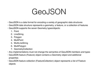
- 1. GeoJSON • GeoJSON is a data format for encoding a variety of geographic data structures • GeoJSON data structure represents a geometry, a feature, or a collection of features • GeoJSON supports the seven Geometry types/objects: 1. Point 2. LineString 3. Polygon 4. MultiPoint 5. MultiLineString 6. MultiPolygon 7. GeometryCollection • Any implementations must not change the semantics of GeoJSON members and types • GeoJSON feature (Feature) object contains a Geometry object and additional properties • GeoJSON feature collection (FeatureCollection) object represents a list of Feature objects
- 2. GeoJSON • GeoJSON’s data structure is represented as a JSON object • GeoJSON object is a JSON object • GeoJSON object represents a Geometry, Feature, or collection of Features • GeoJSON object is a collection of name/value pairs, called as members • In a GeoJSON object, name is always a string • In a GeoJSON object, value can be string, number, object, array, boolean, or null • If a GeoJSON object has a member with the name "type", then the value of the member must be one of the GeoJSON types • If a GeoJSON object may have a "bbox" member, then the value of the member must be a bounding box array
- 3. Geometry Object • Geometry object represents points, curves, and surfaces in coordinate space • Every Geometry object is a GeoJSON object • The value of a Geometry object’s "type" member must be one of the seven Geometry types • The value of Geometry object’s "coordinates" member is an array • The GeoJSON "coordinates" and "geometries" members define Geometry objects
- 4. Feature Object • Feature object represents a spatially bounded thing. • A GeoJSON object with the type "Feature" is a Feature object • Every Feature object is a GeoJSON object • Feature object has a "type" member with a value of "Feature" • If a Feature object has a member with the name "geometry", then the value of the geometry member must be a Geometry object or JSON null value (unknown location/ Feature) • If a Feature object has a member with the name "properties", then the value of the properties member is an object (any JSON object or JSON null value) • If a Feature has a commonly used identifier, then it should be included as a member of the Feature object with the name "id" and the value must be either a JSON string or number • The GeoJSON "geometry" and "properties" members define a Feature object
- 5. FeaturesCollection Object • A GeoJSON object with the type "FeatureCollection" is a FeatureCollection object. • A FeatureCollection object has a member with the name "features" and the value of the "features" member must be a JSON array, where each array element of the array is a Feature object • The GeoJSON "features" member defines a FeatureCollection object
- 6. Bounding Box • Bounding Box also known as the Minimum Bounding Rectangle (MBR) or Envelope • Bounding Box is a Rectangle, oriented to the x and y axes, which bounds a geographic feature or a geographic dataset • Bounding Box is specified by two coordinates: xmin, ymin and xmax, ymax • GeoJSON object may have a member named "bbox" to include information on the coordinate range for its Geometries, Features and FeatureCollections.
- 7. Resources • GeoJSON website • GeoJSON specification • JSON specification • Internet JSON specification • OpenGIS Simple Features Implementation Specification for SQL • Unlocking the Mysteries of Bounding Box by Douglas R. Caldwell • Uniform Resource Identifier for Geographic Locations • World Geodetic System 1984 • NIMA Technical Report TR8350.2, "Department of Defense World Geodetic System 1984, Its Definition and Relationships With Local Geodetic Systems", Third Edition, 4 July 1997 • Open Geospacial Consortium