SlideShare a Scribd company logo
1 of 72
Download to read offline
Scaling Up Marine Science and Conservation
VISIONSTO
REALITY
2018
COVER
Main Image: In early March (two months before Falkor departed for the same mission), two saildrones were deployed from San
Francisco to be a part of the "Voyage to the White Shark Café" expedition.They transmitted data in real-time since their departure,
listening for the acoustic tags that were attached to sharks, while also scanning with a sonar to detect the deep scattering layer.
Hexagon 1: A cirrate octopus has ear-like fins that they use for propulsion.
Hexagon 2: Dr. Camilli directs the delicate deployment of a glider from Falkor's aft deck.
Hexagon 3: A tall chimney in a new hydrothermal vent field discovered in 2018.
Hexagon 4: Trent Lukaczyk prepares a Flightwave Edge for a test flight from the storage deck of the R/V Falkor.
THIS PAGE
Researchers and ship crew inspect an AUV at the beginning of the "Pescadero Vent" expedition.
2018
VISIONSTO
REALITY
VISIONSTO
REALITY
2018
VISIONSTO
REALITY
VISIONSTO
REALITY
2
REPORT
2018
2018
ANNUAL
REPORT
ANNUAL
REPORT
7
Visions coming true
29
Artificial Intelligence
and cloud data analytics
acccelerate marine
science
55
Artistic endeavors
12
Numbers and metrics
(2013-2018)
35
Scaling up marine
conservation with
technical innovation
58
A step ahead:
Improvements &
developments
Table of
CONTENTS
FALKOR
Above: 3D Overview of the proposed Indy Maru Seamount feature with both the summit and deepest location highlighted [CARIS]
[Indy Maru Seamount Supporting Image 005.tif]
Above: Profile line through both the shallowest and deepest point of the proposed Indy Maru Seamount. [Fladermaus]
[Indy Maru Seamount Supporting Image 006.tif]
Table 5.0 – Profile line intersecting the shallowest and deepest point of the proposed Indy Maru Seamount
Length Start End Shallowest Point Deepest Point Total Relief
Profile Line
Shallow to Deep
10306m N 12 07.251,
E 134 45.395
N 12 02.040,
E 134 47.459
1974m
12 04.708669 N
134 46.375966 E
3546m
12 02.2758561 N
134 47.448084 E
1482m
Max Depth
3546m
12 02.2758561 N
134 47.448084 E
Min Depth
1974m
12 04.708669 N
134 46.375966 E
North
START
END
3546m
12 02.2758561 N
134 47.448084 E
1974m
12 04.708669 N
134 46.375966 E
Start End
North
FALKOR
ROV SUBASTIAN
High Performance Computing
Installed Graphics Processing Unit power to Falkor's High Performance Computer
system to support scientists' and researchers' new emerging technologies. A research
vessel first!
Cybersecurity & Falkor’s Network Enrollment
Redesigned the enrollment process for wireless and wired networks through
implementation of a sophisticated software system that protects the entire network from
unauthorized computers or users.
Ship-to-Shore Video Enhancements
By using the core video matrix and cutting edge audio
distribution Falkor crewmembers can now route real-time
events to the encoders and push them straight to the internet
over the satellite connection.
Advanced Shipboard Monitoring
All shipboard network devices are in constant 24/7
monitoring, from servers to the HVAC systems. New
network sensors were added to ensure proper
functionality of shipboard critical systems. Soon all
devices aboard Falkor will send problem alerts to
shoreside technical teams.
Faster Internet
Commissioned hardware and software aboard Falkor for
using 4G data service up to 25 nautical miles offshore;
speed rates are now up to 160 Mbps. The new
shipboard system uses four internal modems to the
packages between the modems and service providers.
A research vessel first!
FALKOR AUDIO VISUAL / INFORMATION TECHNOLOGY / ELECTRONICS
Remote Operation of ROV SuBastian
Designed and tested in-house architecture allowing control of SuBastian tethered to Falkor from a
land-based operating station.
Seafloor Stereo Imagery Capability
SOI's engineers developed a photomosaicing skid mounted under SuBastian to collect high resolution
stereo-imagery of the seafloor around seeps, vents, and whale falls. This skid utilizes SuBastian's new
automated line following capability to combine these image sets into detailed 3D and 2D models for
interactive research and analysis of the seafloor.
Better Vehicle Control
Added new waypoint execution mode for much tighter
line following and control over the speed at which
waypoints are executed.
Operational Procedures
Added new operational procedures to maximize ship time
and dive efficiencies working simultaneously with AUVs
using reconnaissance mapping to pinpoint subsea
targets, and directing the ROV to key study sites.
More Power Options
Installed a science transformer to allow researchers'
instruments to have a greater power range for sensor
integration (i.e. 110v - 220v) and added voltage regulators to
provide lower voltage range (i.e 5v, 6v, 12v & 24v).
Equipment
Expanded growing inventory of scientific instrumentation,
including the integration of 19 new pieces of equipment onto
SuBastain on a single dive.
Catenary Float Rack For
Umbilical
Falkor's Engine Department
fabricated a float rack for the Aft
Deck to allow for a more
ergonomic, safe and efficient
method of stowing and installing
the floats during vehicle
deployment and recovery
operations.
Main Engines
Performed major overhaul of 14 cylinder heads.
Port Main Engine Clutch
Conducted major overhaul.
Sea Water Cooler
Replaced all of the cooler plates.
Emergency Generator
Implemented upgrades to increase main buss capacity and the
supply air ventilation fan capacity.
FALKOR ENGINEERING DEPARTMENT
ROV Event Logger
Developed software logging system to track vehicle technical and scientific
operations as well as scientific ROV operations, allowing for easy annotation,
time stamping and geo stamping of ROV science events. Online access to this
information allows review by shoreside collaborators and staff.
Irradiance Sensors
Falkor's suite of sunlight sensors were relocated and expanded, allowing for
better exposure to the sky and the collection of important new data. Data are
saved in a repository allowing their use by scientists around the globe and
providing historical data for future studies.
FALKOR SCIENCE DEPARTMENT
Falkor sails at sunset in Hawaiian waters.
4
SCALABLE OCEAN RESEARCH WITH
AUTONOMUS ROBOTS
ACCELERATE MARINE SCIENCE
ARTIFICIAL INTELLIGENCE AND
CLOUD DATA ANALYTICS
ARTISTIC
ENDEAVORS
SCALING UP MARINE CONSERVATION WITH
TECHNICAL INNOVATION
SCALABLE OCEAN RESEARCH WITH
AUTONOMUS ROBOTS
ACCELERATE MARINE SCIENCE
ARTIFICIAL INTELLIGENCE AND
CLOUD DATA ANALYTICS
AND SEAFLOOR HABITATS
DIGITIZING MARINE LIFE
ANDSHARING
INSPIRING
ARTISTIC
ENDEAVORS
SCALING UP MARINE CONSERVAT
TECHNICAL INN
SCALABLE OCEAN RESEARCH WITH
AUTONOMUS RO
ACCELERATE MARINE SCIENCE
ARTIFICIAL INTELLIGENCE AND
CLOUD DATA A
AND SEAFLOOR HABITATS
DIGITIZING MAR
ANDSHARING
INSPIRING
ARTISTIC
ENDEAVORS
201
2018
VISIONSTO
REALITY
VISIONSTO
REALITY
21
Scalable ocean research
with autonomus robots
14
Where we have been
2018 Map
43
Digitalizing marine life
and seafloor habitats
60
Noteworthy updates
40
What we found
2013-2018
16
Making waves
2018 Hightlights
48
Inspiring and
sharing
62
Scientific publications and
presentations
2018
26
A working platform
53
Front and center
67
Photo credits
68
Collaborators
LKOR
06
07
09
Above: 3D Overview of the proposed Indy Maru Seamount feature with both the summit and deepest location highlighted [CARIS]
[Indy Maru Seamount Supporting Image 005.tif]
Above: Profile line through both the shallowest and deepest point of the proposed Indy Maru Seamount. [Fladermaus]
[Indy Maru Seamount Supporting Image 006.tif]
Table 5.0 – Profile line intersecting the shallowest and deepest point of the proposed Indy Maru Seamount
Length Start End Shallowest Point Deepest Point Total Relief
Profile Line
Shallow to Deep
10306m N 12 07.251,
E 134 45.395
N 12 02.040,
E 134 47.459
1974m
12 04.708669 N
134 46.375966 E
3546m
12 02.2758561 N
134 47.448084 E
1482m
Max Depth
3546m
12 02.2758561 N
134 47.448084 E
Min Depth
1974m
12 04.708669 N
134 46.375966 E
North
START
END
3546m
12 02.2758561 N
134 47.448084 E
1974m
12 04.708669 N
134 46.375966 E
Start End
North
FALKOR
06
09
Above: 3D Overview of the proposed Indy Maru Seamount feature with both the summit and deepest location highlighted [CARIS]
[Indy Maru Seamount Supporting Image 005.tif]
Above: Profile line through both the shallowest and deepest point of the proposed Indy Maru Seamount. [Fladermaus]
[Indy Maru Seamount Supporting Image 006.tif]
Table 5.0 – Profile line intersecting the shallowest and deepest point of the proposed Indy Maru Seamount
Length Start End Shallowest Point Deepest Point Total Relief
Profile Line
Shallow to Deep
10306m N 12 07.251,
E 134 45.395
N 12 02.040,
E 134 47.459
1974m
12 04.708669 N
134 46.375966 E
3546m
12 02.2758561 N
134 47.448084 E
1482m
Max Depth
3546m
12 02.2758561 N
134 47.448084 E
Min Depth
1974m
12 04.708669 N
134 46.375966 E
North
START
END
3546m
12 02.2758561 N
134 47.448084 E
1974m
12 04.708669 N
134 46.375966 E
Start End
North
5
SCALING UP MARINE CONSERVATION WITH
TECHNICAL INNOVATION
SCALABLE OCEAN RESEARCH WITH
AUTONOMUS ROBOTS
ACCELERATE MARINE SCIENCE
ARTIFICIAL INTELLIGENCE AND
CLOUD DATA ANALYTICS
AND SEAFLOOR HABITATS
DIGITIZING MARINE LIFE
ANDSHARING
INSPIRING
ARTISTIC
ENDEAVORS
SCALING UP MARINE CONSERVATION WITH
TECHNICAL INNOVATION
SCALABLE OCEAN RESEARCH WITH
AUTONOMUS ROBOTS
ACCELERATE MARINE SCIENCE
ARTIFICIAL INTELLIGENCE AND
CLOUD DATA ANALYTICS
AND SEAFLOOR HABITATS
DIGITIZING MARINE LIFE
ANDSHARING
INSPIRING
ARTISTIC
ENDEAVORS
SCALING UP MARINE CONSERVATION WITH
TECHNICAL INNOVATION
SCALABLE OCEAN RESEARCH WITH
AUTONOMUS ROBOTS
ACCELERATE MARINE SCIENCE
ARTIFICIAL INTELLIGENCE AND
CLOUD DATA ANALYTICS
AND SEAFLOOR HABITATS
DIGITIZING MARINE LIFE
ANDSHARING
INSPIRING
ARTISTIC
ENDEAVORS
2
REPORT
2018
2018
ANNUAL
REPORT
ANNUAL
REPORT
John Ryan and Brian Kieft, of Monterey
Bay Aquarium Research Institute
(MBARI), and Gabe Foreman, of
University of Hawaii Manoa, guide LRAUV
Opah off R/V Falkor's aft deck during the
autonomous robot's deployment.
6
201
2018
VISIONSTO
REALITY
VISIONSTO
REALITY
VISIONS COMING TRUE
Artificial Intelligence and Robotics Begin to Transform Ocean Conservation and Research
The ocean gives life. It is no surprise that the abundance of liquid
water is the principal habitability criterion in astrobiology. From the
earliest emergence of life on Earth, the ocean has played a crucial
part in sustaining it. For millennia, the seas have produced most of
the oxygen we breathe, regulated our weather, and supplied critical
nutrients and resources - despite the global disturbances from human
activity in the recent decades.
Rapid ocean warming, acidification, deoxygenation, pollution, and
overexploitation push marine life to the edge of survival. More than a
quarter of all known oceanic species are losing a place to call home.
Global scale and furious rate of change call for dramatic acceleration
in our ability to understand, foresee, and avert their harmful effects.
The developments in robotics, artificial intelligence (AI), and other
technology frontiers can offer effective tools to accelerate ocean
research, conservation, and management at scale.
Established nearly a decade ago to advance ocean research with
innovation, Schmidt Ocean Institute completed its busiest and most
productive year in 2018. Research vessel Falkor spent 243 days at
sea supporting 11 select research projects, including 135 days with
remotely operated vehicle SuBastian onboard.
At SOI, we are gearing up for the future, and
the new ways oceanography will be done. We
are always excited and curious to see what
scientists who conduct research on board
Falkor will come up with, and how, together,
we can push the existing boundaries of marine
research.
- Wendy Schmidt.
These are all records for SOI. However, what hides behind these
numbers is the true impact of the program. In this report, we
discuss a series of transformative innovations demonstrated by SOI
in 2018 to illustrate how we can scale our capacity to understand
and better conserve our ocean. One example of this transformation
took place in February when two Saildrones, unmanned surface
wind and solar powered vehicles, were launched to the White
Shark Café to study why this remote area attracts white sharks.
Traversing thousands of miles halfway between Hawaii and California,
Saildrones surveyed the region for a month ahead of Falkor’s arrival.
Their early entrance informed the scientific sampling plans, gathering
rich sensor data that showed how small-scale eddies draw nutrients
closer to the surface to enhance biological production; a good reason
why the sharks may be drawn to this area. Following the expedition,
the Saildrones duties were extended to track an oceanic front for SOI’s
next project a couple thousand miles away. These examples show
how the Saildrones can be applied to future seagoing oceanography,
where operational flexibility, endurance, low environmental impact, and
excellent observational data can reduce operational costs and risks.
This shift will make critical elements of marine field science accessible
to oceanographic researchers around the world.
Co-founders Eric and Wendy Schmidt.
7
2
REPORT
2018
2018
ANNUAL
REPORT
ANNUAL
REPORT
Several projects this year focused on developing AI and machine
learning tools to support marine science and management in near real
time. In January, teams from Massachusetts Institute of Technology
(MIT) and University of Sydney tested artificial intelligence (AI) -based
multi-vehicle ocean survey software from aboard Falkor using SOI’s
high performance computer. The model was analyzed to inform real
time planning of operations to collect valuable data as the survey
progressed. SOI, in collaboration with the University of Porto, also
developed Ocean Space Center software that was used in May to
automatically guide dozens of aerial, surface, and submarine robots
as they mapped the dynamic subtropical pacific ocean front in high
resolution and 3D. The advanced software managed successful multi-
robotic ocean surveys while requiring only one human observer in
Falkor’s science control room.
In July, teams from the Universities of Southampton and Tokyo,
compiled the largest known centimeter-resolution color 3D map of
deep seafloor from 1.3 million photos acquired on site at Hydrate
Ridge off the coast of Oregon. They used unsupervised machine
learning at sea to quickly find the areas of scientific interest and study
rapidly changing seafloor that would otherwise be virtually impossible
to find and sample within the cruise timeframe.
Duringthefinalexpeditionoftheyear,Falkorhostedateamofroboticists
developing advanced AI for autonomous planetary exploration in
deep space that will tolerate large communications latencies. The
researchers tested non-deterministic ocean surveying, where robots
could "locate gas seeps", "find rock formations", and "survey biological
hotspots" without being explicitly programmed to do so and by having
to learn the specifics of such tasks from diverse ocean data and expert
annotations. In a successful demo, 11,000 square miles of ocean were
intelligently surveyed within nine days. Highlighted by these projects, AI
and machine learning are on the path to become indispensable for the
future of oceanography.
With these unique journeys of discovery and development, SOI
continues to bring the ocean to people in their communities, schools,
workplaces, and recreation groups. With these unique journeys of
discovery and development, SOI continues to bring the ocean to
people in their communities, schools, workplaces, and recreation
groups. High-resolution imagery from ROV SuBastian has been viewed
in real time on our YouTube channel by more than half a million people
and featured in 15 documentaries this year. New collaborations with
the Smithsonian Museum and Aquarium of the Pacific have allowed us
to connect scientists with greater numbers of people on shore.
Dr. Blair Thornton guides one of ROV SuBastian's dives during the "Adaptive Robotics"
expedition in R/V Falkor's control room, using the maps and images acquired by the
AUVs and processed by unsupervised algorithms. The expedition used a suite of
AUVs with different mapping capabilities and specialties to gather the bathymetry data
for the experimental Artificial Intelligence software to decipher.
8
201
2018
VISIONSTO
REALITY
VISIONSTO
REALITY
And SOI helps to make Falkor-related scientific articles open access so
anyone can read the details from research done at sea.
2018 was a remarkably productive year for science, and for sharing the
joy and excitement of our discoveries and achievements. This is just
one of the reasons SOI was named by Marine Technology Reporter as
one of the Top 10 Ocean Influencers.
This year our report is organized by themes that are building a
foundation of success for the future. Readers will find details on how
we are contributing to the arts, advancing ROV SuBastian’s capabilities,
sharing our incredible footage, and connecting with the public. We
hope you will be inspired as much as we have been by our supported
projects and research teams, technical innovations, and wondrous
marine discoveries that have marked 2018.
Crew of the "Pescadero Vent" expedition recover the mapping AUV D. Allan B. This autonomous underwater vehicle is equipped with four mapping sonars that operate
simultaneously during a mission: a swath multibeam sonar, two sidescan sonars, and a sub-bottom profiler. The multibeam sonar produces high-resolution bathymetry
(analogous to topography on land), the sidescan sonars produce imagery based on the intensity of the sound energy’s reflections, and the sub-bottom profiler penetrates
sediments on the seafloor, allowing the detection of layers within the sediments, faults, and depth to the basement rock.
9
AE2000f was the "Adaptive Robotics" expedition's scout.
It would cruise at about 20km/h, collecting preliminary images of
the seafloor: this data was then used to determine where the rest
of the robots should focus their efforts.
10
REPORT
ANNUAL
REPORT
11
VISIONSTO
REALITY
FALKOR
350 K
Km traveled.
A Distance Greater
Than Circling the Globe
9 Times
ROV SUBASTIAN
324 ROV
Dives 737 ROV
Samples
Collected
497 Hrs livestreamed
on YouTube
1,176
Science Days
752
Scientists
from 165 Institutions
in 30 Countries
304
AUV Dives
36
UAVs
Launched
Totaling
31.3 Hours
1,231
CTD Casts261
Students
x9
2013-2018
NUMBERS AND METRICS
12
2
REPORT
2018
2018
ANNUAL
REPORT
ANNUAL
REPORT
ARTIST-AT-SEA
2018 DATA
GB
Falkor and SuBastian Data
Downloaded from MGDS
763
74TB
of Data
KM2
of Falkor Mapping Data Merged
into GMRT since 2012
573,590
DAYS OF DATA
Sent to SAMOS
203
DATA FILES
Downloaded from MGDS
7, 326Sent to and Quality Processed
by SAMOS
272,160 REPORTS
People on Facebook
1 million+
2018 SOCIAL MEDIA
2018 OUTREACH
128
BLOGS
121
EXPEDITION
VIDEOS
1,716,000
MINUTES
of YouTube Video
Watched
38
DOCUMENTARIES
AND EXHIBITS
Using SOI footage
2,741
PEOPLE REACHED
Through Community
Presentations
1,000
PEOPLE WELCOMED
onto Falkor for Tours
531,460
Used the SOI Website
Created through the Program
99
PIECES OF ARTWORK
21
ARTISTS
14
EXHIBITS
in 10 Different Cities
90
LIVE SHIP TO SHORE
CONNECTIONS
Viewed By 8,187 People
on YouTube, 51% Increase
from 2017
528,475
VIEWS
REACHED
Impressions on Twitter
1,990,900
Instagram Likes
20,308
13
201
2018
VISIONSTO
REALITY
VISIONSTO
REALITY
Number: FK180722
Location: San Diego to Astoria, United States
Date: July - August
The Seeping Cascadia
Margin
Coordinated Robotics:
ʻAuʻAu Channel
Number: FK180119
Location: Honolulu, United States
Date: January - February
01
02
Number: FK180420
Location: Honolulu to San Diego, United States
Date: April - May
Exploring Fronts with
Multiple Robots
Number: FK180528
Location: San Diego, United States
Date: June
Solving Microbial Mysteries
with Autonomous Technology
Number: FK190624
Location: San Diego, United States
Date: June - July
Voyage to the White
Shark Café
Adaptive Robotics at Barkley
Canyon & Hydrate Ridge
Number: Fk180731
Location: Astoria, United States
Date: August
Eddy Exploration and
Ecosystem Dynamics
Number: FK180310
Location: Honolulu, United States
Date: March - April
Number: FK190824
Location: Astoria to San Francisco, United States
Date: August - September
03
04
05
06
07
Characterizing Venting and Seepage
Along the California Coast
Number: FK181005
Location: San Francisco to San Diego, United States
Date: October
Interdisciplinary Investigation of a New
Hydrothermal Vent Field
Number: FK181031
Location: San Diego, United States to
Manzanillo, Mexico
Date: November
New Approaches To Autonomous
Exploration At The Costa Rican Shelf
Break
Number: FK181210
Location: Puntarenas, Costa Rica
Date: December
08
09
10
11
Hunting Bubbles: Understanding
Plumes of Seafloor Methane
Conducted research in Mexican
waters working closely with the U.S.
Embassy in Mexico City. Hosted a
foreign observer from the Deputy General
Directorate of Oceanography, Hydrography
and Meteorology onboard Falkor for the cruise
and will be sharing the expedition data with
local scientific agencies.
Hosted tours on Falkor for several
Costa Rican dignitaries and U.S.
Embassy affiliates in San Jose.
WHERE
we have been
The deep ocean is still one of
the least explored frontiers in
the solar system. Maps of our
planet are not as detailed as
those of Mercury, Venus, Mars
or the Moon, because it is
hard to map underwater. This
is the frontier.
- Robert Zierenberg,
Principal Investigator.
14
2
REPORT
2018
2018
ANNUAL
REPORT
ANNUAL
REPORT
03
10
05
11
07
08
09
06
04
02
01
15
201
2018
VISIONSTO
REALITY
VISIONSTO
REALITY
2
REPORT
2018
2018
ANNUAL
REPORT
ANNUAL
REPORT
MAKING WAVES
2018 Highlights
Coordinated Robotics 2, Hawaii Eddy Exploration & Ecosystem Dynamics, Hawaii Voyage to the White Shark Cafe, California
Improved marine surveys by teaching
robots to collaborate and share knowledge
Achieved the longest deployment of
Environmental Sampling Processors on
Long Range AUVs
Protected white sharks with Saildrones and
shipboard eDNA
Demonstrated from aboard Falkor coordinated operations
and data-driven site selection with multiple autonomous
underwater vehicles. Refining techniques using several
vehicles will make habitat mapping simpler and easier for a
more scalable approach that can present follow-on benefits
for management and policy-making.
Completed the first open ocean deployment of long
range autonomous underwater vehicles (LRAUVs); they
are the only AUVs that can survey filtered seawater insitu
and allow for sampling in remote or dangerous locations.
Seawater collected with the LRAUVs is being sequenced
to determine microbial communities found at the ocean
surface, this is important baseline information to have as
seawater temperatures increase.
Documented the oceanographic conditions and biological
productivity of a white shark congregation zone. This was
achieved with a multi-platform sampling program coupling
Falkor, SuBastian, and two Saildrone autonomous surface
vehicles, gathering crucial ocean currents and animal
density data. The data will illuminate this little-studied
ecosystem and contribute to the conservation efforts of the
high seas.
Prof. Williams and Dr. Lachlan
Toohey continue their work
with the NextGen vehicle, long
after dark.
1616
201
2018
VISIONSTO
REALITY
VISIONSTO
REALITY
Exploring Fronts with Multiple Robots, California Solving Microbial Mysteries, California The Seeping Cascadia Margin, Oregon
Located and mapped a Pacific subtropical
ocean front using a coordinated fleet of
robots
Tested in situ microbial incubators to
understand how marine life adapts to
oxygen depletion in the ocean
Reached non-science audiences with
artistic visualization of marine data
Tracked, mapped, and sampled a mesoscale filament
of a major ocean front with multiple autonomous
underwater, surface, and aerial vehicles using open-source
communication. The technologies represent an important
step towards achieving the levels of persistence, spatial and
temporal resolution, as well as coverage, required for ocean
studies in a changing climate.
Tested and refined an autonomous in situ incubation device
allowing shipboard scientists near-continuous monitoring
in an oxygen deficient ocean system. The seawater
incubations will provide better insight into how microbes
interact with each other and their chemical environment.
The refinements in low oxygen marine system operations
will help scientists better understand the ocean’s role in
moderating climatic changes.
Created detailed mid-water and seafloor maps in an
unsurveyed methane seep region with six artists and two
Student Opportunities participants. The maps will be used
to identify where hydrocarbon seeps are occurring and
their flow activity for future observation and research. The
artists captured the mapping work of Falkor’s shipboard
marine technicians with striking art forms including a light
painting performance, oceanscape resin art, woodworking
sculpture, portrait painting, cyanotype prints, and a life-size
mural of the Pseudoliparis swirei ghost fish.
Chief Scientist Andrew Babbin examines the
in-situ incubators.
17
2
REPORT
2018
2018
ANNUAL
REPORT
ANNUAL
REPORT
Adaptive Robotics at Hydrate Ridge, OregonHunting Bubbles: Understanding Plumes of Seafloor
Methane, Oregon
Characterizing Venting and Seeping, California
Revealed new sites and species in the
California Borderland
Developed new ways to understand ocean
cycles via methane bubbles
Guided exploration and research of
changing seafloor habitats with AI
Gained insight into the role of gas vents and seeps in the
ecology of the Southern California Borderland, using ROV
SuBastian and the advanced seafloor observatory (ABISS).
The ABISS lander deployments showed that methane
venting is more episodic than previously known, which
changes assumptions about methane escape from the
seafloor to the atmosphere. The science team is producing a
map of the contiguous seeps and analyzing the relationships
among the animals, including potentially new species, to
understand the connectivity of these habitats.
Installed a novel bubble capture system on ROV SuBastian
to take chemical measurements of bubble composition
and gather data on the chemical dynamics of bubbles. The
development of this equipment (and cutting-edge sensors)
is important in illustrating changes in methane from venting
locations across a spatial scale and over time. The large
flux of this methane into the ocean may indirectly play an
important part in the carbon cycle, which is closely linked to
Earth’s climate.
Used unsupervised learning techniques with 3D
reconstruction pipelines to analyze imagery collected
between AUV deployments. As a result, the largest known
continuous photogrammetric reconstruction of seafloor
mapped at sub-centimeter resolution was created, including
an 11.4 hectare dense 3D image reconstruction. Developing
end-to-end autonomy is critical to scale robotic operations
so that hundreds may be deployed simultaneously in the
future, giving scientists the ability to monitor larger areas and
understand the ocean more efficiently.
Dr. Scott Wankel preparing the mass
spectrometer that will live on SuBastian
during the next month - giving near
real time continual measurements of
methane.
18
201
2018
VISIONSTO
REALITY
VISIONSTO
REALITY
Interdisciplinary Investigation of a New Hydrothermal
Vent Field, Mexico
New Approaches to Autonomous Exploration, Costa
Rica
Conducted centimeter-scale AUV survey of
hydrothermal vents in Pescadero Basin
Tested AI-driven robots for a possible
extraterrestrial mission
Doubled viewership of incredible 4K deep-sea imagery
from ROV SuBastian. This resulted in the use of footage
in documentaries, television, and museum exhibits at the
Dundee Heritage Trust, and Barbican Museum. We also
hosted public ship tour days during US port calls, bringing
more than 1,000 people on board. Additionally, SOI continued
our traveling Artist-at-Sea exhibit showcasing 11 new artists at
venues including Aquarium of the Pacific, Exploratorium, and
the NOAA Exploration Forum. The works incorporate data
collected during expeditions and have been used for outreach
by the scientists as well.
Broadened participation in ocean sciences
Completed centimeter scale resolution mapping resulting
in the discovery of a new vent field (JaichMaat). The list of
species occurrences for the area was significantly expanded
and the team collected several animals that may represent
new species. The discovered site is an important location
to try to understand how vent fauna colonize, evolve, and
speciate.
Operated multiple self-controlled robotic vehicles while
successfully developing AI for autonomous exploration and
research of remote uncharted environments. This technology
will support future oceanographic and planetary exploration,
where due to communications latencies robots routinely need
to make tactical decisions without human intervention.
Richard Camilli, Principal Investigator of
the "New Approaches To Autonomous
Exploration At The Costa Rican Shelf
Break" and David Pinga assemble a
Sloucm glider in R/V Falkor's wet lab.
19
The autonomous vehicles - aerial and
underwater - utilized by the Ocean Robots
Team line the aft deck of R/V Falkor.
The challenge is trying to do as much
as we can to help people make
sensibledecisions.Havingmoreocean
observationsiscriticaltogoodscience
and providing a comprehensive view
of what is happening, and how things
are changing. This will build our ability
to understand the ocean, and to make
wiser decisions and policies in the
future.
- Oscar Pizarro,
Principal Investigator.
20
ARTISTIC
SCALABLE OCEAN RESEARCH WITH
ENDEAVORS
AUTONOMUS ROBOTS
ARTIFICIAL INTELLIGENCE AND
21
DATA-DRIVEN CORAL REEF SURVEYS WITH COORDINATED ROBOTIC TEAMS
SCALABLE OCEAN
RESEARCH
with Autonomous Robots
The ocean is too large to observe with conventional means. SOI recognizes that in order to make meaningful advances there must be more agile,
resilient, and robust platforms. Robots and AI can greatly improve coverage and cost-efficiency for select ocean observations by reducing risk, and
facilitating high resolution spatially distributed surveys of dynamic marine processes, as illustrated by the projects discussed in this section.
In January, SOI welcomed Dr. Oscar Pizarro,
Australian Centre for Field Robotics (ACFR),
and his collaborators from MIT and the
University of Sydney back aboard Falkor
to research and demonstrate multi-robotic
surveys of coral reefs. As part of this project,
SOI supported the development and testing
of data-driven planning algorithms for
autonomous marine surveys completed by
heterogeneous robots.
Thiswasillustratedbyrunningaconsolidated
model of a coral reef (in the ‘Au’Au channel
off Maui, HI) on Falkor’s high performance
computer that was continuously
updated with new data gathered by
the robotic systems. As each vehicle
transmitted fresh observational data to the
common model, the software algorithms
updated the estimates of uncertainty
for each feature of scientific interest.
This resulted in identified locations and
parameters to be surveyed next by each
vehicle, taking in account their operational
status, positions, and sensing capabilities.
The coordinated robots collected over half
a million georeferenced images covering
77,453 square meters of seafloor.
“The challenge is trying to do as
much as we can to help people make
sensible decisions,” said Dr. Pizarro.
“This expedition was an opportunity to
try techniques that automate science
plans. Having more ocean observations
is critical to good science and providing
a comprehensive view of what is
happening, and how things are changing.
This will build our ability to understand the
ocean, and to make wiser decisions and
policies in the future.”
georeferenced images along the
the 'Au'Au Channel covering
77,453 m2
of seafloor
COLLECTED MORE
THAN 500,000
Researchers work on a programming and optimizing an
Iver autonomous vehicles in Falkor's Wet Lab.
22
SCALING UP MARINE CONSERVATION WITH
TECHNICAL INNOVATION
SCALABLE OCEAN RESEARCH WITH
AUTONOMUS ROBOTS
ACCELERATE MARINE SCIENCE
ARTIFICIAL INTELLIGENCE AND
CLOUD DATA ANALYTICS
AND SEAFLOOR HABITATS
DIGITIZING MARINE LIFE
ANDSHARING
INSPIRING
ENDEAVORS
georeferenced images along the
the 'Au'Au Channel covering
77,453 m2
of seafloor
COLLECTED MORE
THAN 500,000
data stations
80
300 m
LRAUVs sample to depths of
with an operational range of
1,000 km
CTD casts
28 shark satellite pop-up
tags recovered
10 yielding 70+ hours of
midwater observations in
habitat never before surveyed
9 SuBastian Dive
ADAPTIVE MICROBIAL SAMPLING OF OCEANIC EDDIES WITH LONG RANGE AUVS
The second Falkor expedition of the year
was led by Drs. Sam Wilson and Steve
Poulos, University of Hawaii, in collaboration
with the Monterey Bay Aquarium Research
Institute (MBARI), giving way to the first-
ever open ocean deployment, microbial
sampling, and insitu data analysis by
long range autonomous underwater
vehicles (LRAUVs). The LRAUVs are a
great engineering feat that enable ocean
observation and sampling in remote
locations.
Deploying multiple LRAUVs simultaneously
allowed the research team aboard Falkor
to adaptively sample a moving ocean
eddy field. This research set a new record
for the duration of this type of mission,
and characterized in unprecedented detail
microbial communities found in eddy
fields. The vehicles captured and analyzed
environmental samples in situ while
being able to amend and guide their own
sampling patterns based on onboard data
analyses. The three LRAUVs were fitted
with next generation Environmental Sample
Processors (ESPs) and other sensors to
monitor seawater parameters and identify
hydrographic features that are likely to host
interesting microbial processes.
The results were stunning, never before in
microbial oceanography have researchers
been able to sample the open ocean deep
chlorophyll maximum and other parameters
with this level of precision.
The vehicles offer a novel perspective of
these common yet poorly understood
oceanic microbial processes. Seawater
collected with the LRAUVs is being
sequenced and analyzed to determine
the structure and composition of the
resident marine microbial communities.
The samples will help tell us how marine
microbes interact with each other in space
and time.
LRAUVs were programmed with missions to detect
features inside eddys. When a feature is
discovered, the LRAUVs lock in
and can track the feature for
days at a time.
We need to understand these microscale
processes in order to comprehend bigger
processes such as carbon cycling across
the global ocean basins.
Researchers prepare
to launch a LRAUV
from Falkor's midship.
23
20120182018201820182018
VISIONSTO
REALITY
VISIONSTO
REALITY
VISIONSTO
REALITY
VISIONSTO
REALITY
VISIONSTO
REALITY
VISIONSTO
REALITY
georeferenced images along the
the 'Au'Au Channel covering
77,453 m2
of seafloor
COLLECTED MORE
THAN 500,000
data stations
80
300 m
LRAUVs sample to depths of
with an operational range of
1,000 km
CTD casts
28 shark satellite pop-up
tags recovered
10 yielding 70+ hours of
midwater observations in
habitat never before surveyed
9 SuBastian Dives
MID-OCEAN RESEARCH AND MONITORING OF WHITE SHARKS WITH
SAILDRONES
Science on Falkor was guided for the first
time by two sensor-laden Saildrones,
autonomous surface vehicles with unlimited
range and endurance.
These long-range vehicles were launched
from San Francisco Bay, reaching the White
Shark Café a month ahead of Falkor’s arrival
to characterize oceanographic conditions,
currents, and animal densities in the open
ocean region halfway between Hawaii and
the Baja California Peninsula.
The data gathered was critical for the
shipboard research team to accurately
identify the white shark congregation area
that was later studied with Falkor and
SuBastian.
Dr. Barbara Block, Stanford University, and
her international team, led this study to
understand why this remote and desolate
area attracts massive-sized white sharks
each year. A greater understanding of this
otherwise unknown habitat for sharks was
achieved with a multi-platform sampling
program coupling Falkor with shore-
launched robotic vehicles working in
tandem. The shipboard team was able to
locate all shark tags that were deployed in
the previous fall off the coast of California.
Scientific observations, data collection,
and sample analysis, including shipboard
eDNA sequencing, continued on Falkor.
The data provided important new insights
into the habitat and white shark behavior.
For instance, Saildrone data showed
how small-scale ocean eddies draw
nutrients closer to the surface, enhancing
biological production, which could make
this region more appealing for sharks. This
finding offered a valuable head start to the
scientists in addressing the key questions of
their study.
“We have doubled the current 20-year
data set on white shark diving behaviors
and environmental preferences in just three
weeks using tools that provided a rapid
census of the predators and prey of a
remote ocean region,” said Dr. Block. “This
helps establish observations that will allow
for better understanding of this environment
and why it attracts large predators.”
Main Image: PhD candidate Elizabeth Andruszkiewicz, Dr. Nathan Truelove and PI Dr. Barbara Block celebrate
having successfully isolated DNA from the first CTD cast. The results are positive for vertebrates - including sharks.
Detail Image: This is a pop-up satellite archival tag used on the sharks - it has a light sensor, a temperature sensor,
a pressure sensor, and a very accurate clock. It goes on the white shark, the shark carries the tag, and then at a point
chose and programmed by the researchers, it pops off. A float takes it to the surface and it sends radio transmissions
to Earth orbiting satellites.
24
SCALING UP MARINE CONSERVATION WITH
TECHNICAL INNOVATION
SCALABLE OCEAN RESEARCH WITH
AUTONOMUS ROBOTS
ACCELERATE MARINE SCIENCE
ARTIFICIAL INTELLIGENCE AND
CLOUD DATA ANALYTICS
AND SEAFLOOR HABITATS
DIGITIZING MARINE LIFE
ANDSHARING
INSPIRING
ENDEAVORS
Top Image: Trent Lukaczyk prepares
a Flightwave Edge for a test flight
from the storage deck of the R/V
Falkor.
Middle Image: Crew and science team including John Ryan (MBARI),
Allan Doyle (Chief officer Falkor), Brian Kieft (MBARI), and Gabe Foreman (of
University of Hawaii Manoa) begin to guide LRAUV Opah off R/V Falkor's​ aft
deck during the autonomous robot's deployment.
Bottom Image: A Flightwave Edge UAV, piloted by Trent
Lukaczyk, flies towards R/V Falkor. The Unmanned Aerial
Vehicle worked in concert with underwater robotics and the
crew onboard the ship gathering data.
STRETCHING THE LIMITS OF ROBOTIC
AUTONOMY FOR OCEAN SURVEYING
While returning to California, the two Saildrones were remotely
re-tasked to support a project led by Dr. João de Sousa,
University of Porto. The robust multi-vehicle mission used
planning and control algorithms to enable real-time analysis of
complex ocean dynamics, specifically locating, tracking, and
measuring the North Pacific Subtropical Front.
This multi-platform approach was completed with
many low cost vehicles deployed from Falkor in different
mediums, including underwater, surface and air. More than
a dozenrobotic systems were deployed and simultaneously
operated by an SOI-supported Ocean Space Center software
running aboard Falkor, allowing the researchers to map the
oceanic feature in high, sub-mesoscale resolution, including
space and time.
To coordinate the operations of multiple robotic platforms, the
team flew unmanned aerial vehicles (UAVs) over the areas of
operations to collect oceanographic observations, serving as
“mules” to ferry data between distant AUVs and the Falkor.
By the end of the expedition, the AUVs traveled over 3,430
kilometers for approximately 500 hours; and the UAVs
performed over 25 flawless flights totaling 10 hours.
The technologies used on this expedition represent an
important step towards achieving the levels of persistence,
spatial and temporal resolution, as well as coverage, required
for scalable ocean studies in a changing climate . “Oceans
are the Earth’s life support system. To be properly taken care
of, they need to be characterized with much higher resolution
and coverage in time in space than what’s possible with
ships,” said Dr. de Sousa.
25
20120182018201820182018
VISIONSTO
REALITY
VISIONSTO
REALITY
VISIONSTO
REALITY
VISIONSTO
REALITY
VISIONSTO
REALITY
VISIONSTO
REALITY
A WORKING
PLATFORM
VOYAGE TO THE
WHITE SHARK CAFÉ
EDDY EXPLORATION AND ECOSYSTEM DYNAMICS
EXPLORING FRONTS WITH
MULTIPLE ROBOTS
SOLVING
MICROBIAL
MYSTERIES WITH
AUTONOMOUS
TECHNOLOGY
SIRIUS AV NEXT GEN AUV IVER 2 LAGRANGIAN FLOAT
WAM-V 16’ CATAMARAN ASV
AUV IVER 3
SLOCUM GLIDER
COORDINATED ROBOTICS: ʻAUʻAU CHANNEL
LONG RANGE AUVS
(Aku ,Ahi, Opah)
SEAGLIDER WAVE GLIDER WIRE WALKER
x3 x2 x2
SAILDRONE
x2
SAILDRONE
x2
VERTICAL TAKE-OFF
AND LANDING UAVS
UAVS
x3
x6
ROV SUBASTIAN
A WORKING
PLATFORM
AUV IVER 2
LIGHT AUVS
WAVEGLIDER FREE FLOATING IN-SITU
INCUBATORS
suspended at depth from a float
x2
26
2
REPORT
2018
2018
ANNUAL
REPORT
ANNUAL
REPORT
HUNTING BUBBLES: UNDERSTANDING PLUMES OF SEAFLOOR METHANE
ROV SUBASTIAN WITH BUBBLE
ACCUMULATION CHAMBER
JET-YAK
ROV SUBASTIAN AE2000F TUNA-SAND TUNA-SAND 2
ADAPTIVE ROBOTICS AT BARKLEY CANYON & HYDRATE RIDGE
ABISS LANDER
INTERDISCIPLINARY
INVESTIGATION OF A NEW
HYDROTHERMAL VENT
FIELD
CHARACTERIZING VENTING
AND SEEPAGE ALONG THE
CALIFORNIA COAST
ROV SUBASTIAN
WITH FIRST
SUCCESSFUL
PHOTOMOSACING
SLED
ABISS LANDER
ROV SUBASTIAN WITH
MBARI MAPPING SLED WITH LIDAR
IN SITU MASS &
LASER SPECTROMETER
IN SITU MASS AND
LASER SPECTROMETER
DIVE
#
DORADO AUV
27
201
2018
VISIONSTO
REALITY
VISIONSTO
REALITY
Chief Scientist Blair Thornton consults the
visual map of the seafloor, in order to confirm
the location to send ROV SuBastian.
It is amazing to see large areas of
the seafloor mapped only days
after the raw data was collected.
It is not just the size of the map,
but the way we used it to inform
our on-site decisions. This makes
a real difference as the technology
allowsustovisualizewideareasat
high resolution, and select where
we should collect data. This has
not previously been possible.
- Blair Thornton,
Principal Investigator.
28
ARTISTIC
SCALABLE OCEAN RESEARCH WITH
ENDEAVORS
AUTONOMUS ROBOTS
ACCELERATE MARINE SCIENCE
ARTIFICIAL INTELLIGENCE AND
CLOUD DATA ANALYTICS
SCALING UP MARINE CONSERVATION WITH
29
ARTIFICIAL INTELLIGENCE
and Cloud Data Analytics Accelerate Marine Science
SOI-SUPPORTED SCIENTIFIC IMAGE ANNOTATION SOFTWARE BECOMES A NATIONAL STANDARD
Ocean observing data is growing at an accelerating pace, however, more is needed to enable well informed, ocean conservation and management.
Many conventional workflows for marine data processing in ocean conservation and research are not automated, inhibiting the productivity of researchers
and managers. This year SOI focused on projects leveraging the utilization of Falkor and ROV SuBastian that worked towards automating marine data
analysis workflows to accelerate the understanding of our rapidly changing marine habitats and multiply the conservation benefits.
Squidle+ is a web-based open source software for the annotation of
marine scientific images, videos, and photomosaics. SOI has supported
the development of this software since 2015 when it was initially
deployed as part of a Falkor-hosted R&D project. The near-real-time
crowd-sourced annotation of AUV acquired seafloor imagery has been
further developed by SOI for shipboard ROV SuBastian annotation and
event logging.
The enhanced version of Squidle+ has been adopted by the Australian
National Environmental Science Program and Japan Agency for Marine
Science and Technology as the preferred platform for annotating
images. Other government agencies such as Canada’s Department of
Fisheries and Oceans and U.S.’s National Oceanic and Atmospheric
Administration are exploring using the platform for their image annotation
purposes as well.
Dr. Richard Camilli directs the
deployment of a Slocum glider
from Falkor's aft deck off the
coast of Costa Rica.
30
SCALING UP MARINE CONSERVATION WITH
TECHNICAL INNOVATION
AUTONOMUS ROBOTS
ACCELERATE MARINE SCIENCE
ARTIFICIAL INTELLIGENCE AND
CLOUD DATA ANALYTICS
AND SEAFLOOR HABITATS
DIGITIZING MARINE LIFE
ANDSHARING
INSPIRING
COMPILING AND ANALYSING THE LARGEST KNOWN CENTIMETER-RESOLUTION MODEL OF SEAFLOOR
In August, Dr. Blair Thornton, University of Southampton, and his
collaborators from the UK and Japan deployed two AUVs from
Falkor to acquire 1.3 million seafloor images of changing microbial
habitats surrounding methane seeps off the U.S. West Coast.
The team used shipboard high performance computers to rapidly
compose these images into the largest known centimeter-resolution
color 3D model of 11.4 hectares of the seafloor. An unsupervised
machine learning algorithm was used to cluster the images by visual
similarity and locate continuously changing microbial hotspots
on the seafloor. Detailed surveys were conducted using ROV
SuBastian the following day.
This project demonstrated how throughput data processing and
machine learning can multiply the productivity of marine scientists.
It allowed the team to make quick and well-informed sampling
decisions and conduct fine scale surveys to study habitats that
would otherwise be virtually impossible to observe in detail. The
resulting composite map was invaluable in planning operations,
including the recovery of seafloor instruments, re-visiting active
bubble plumes, and made the entire operation more efficient.
Using AI, scientists have the ability to gather data and make
decisions in expedition relevant time frames, prompting better use
of the robotic systems deployed at sea.
A) 3D photogrammetric reconstruction of the Southern Hydrates Ridge (depth 780 m) that was generated by the AUV Ae2000f. The mapped area covers 11.8 ha at an average
resolution of 6 mm and is the largest known expanse of seafloor that has been visually mapped in colour. The Falkor shown to scale in the top left of the panel.
B) Outputs of an unsupervised classifier that was used to analyze the imagery between deployments and generated information summaries such as the image class matrix E).
C) White bacterial mat that was identified by the classifier, which was subsequently surveyed by the AUV Tuna-sand at sub-millimeter resolution to gather more detailed information.
The arrow in C) illustrates the direction from which the isometric view of the reconstruction is viewed in D).
31
2012018201820182018
VISIONSTO
REALITY
VISIONSTO
REALITY
VISIONSTO
REALITY
VISIONSTO
REALITY
VISIONSTO
REALITY
Falkor’s last expedition of 2018
hosted specialized teams, including
computer scientists, roboticists, and
oceanographic researchers from Woods
Hole Oceanographic Institution (WHOI),
MIT, NASA, ACFR, and the University of
Michigan. The groups worked together,
developing advanced AI for autonomous
robotic exploration of remote uncharted
environments. This technology will support
future planetary exploration in space
and in deep sea habitats, where due to
communications latencies, robots need
to make tactical decisions without human
intervention.
TEACHING ROBOTS TO LEARN
FROM DATA TO PLAN AND
EXECUTE OCEAN SURVEYS
Left Image: Navigator Officer Marissa Judkins is part
of the team performing final checks before launching
TUNA-SAND. With its systems and navigation
capabilities tested and confirmed, it is ready to begin
work at the sea floor.
Ultimately, our goal is to use what
we have learned to inform the
design of fully autonomous robots
that will one day explore the
oceans of Europa and Enceladus.
- Richard Camili,
Principal Investigator.
32
SCALING UP MARINE CONSERVATION WITH
TECHNICAL INNOVATION
AUTONOMUS ROBOTS
ACCELERATE MARINE SCIENCE
ARTIFICIAL INTELLIGENCE AND
CLOUD DATA ANALYTICS
AND SEAFLOOR HABITATS
DIGITIZING MARINE LIFE
ANDSHARING
INSPIRING
Top Image: Richard Camilli, Principal Investigator of the
"New Approaches To Autonomous Exploration At The
Costa Rican Shelf Break" and David Pinga assemble a
Sloucm glider in R/V Falkor's wet lab.
Hexagon 1: Technicians Tetsu Koike and Kazunori
Nagano work on the camera load onboard AE200f,
which is advancing visual recordings made while
exploring the ocean floor.
Hexagon 2: ROV pilot Jason Rodriguez wears eye
detection glasses, which record his eye motions and
focus, as part of the data that will be used to train robotic
algorithms.
One of the developed science software
tools, the AI/machine learning-based
autonomous planner "Spock," was tested
aboard Falkor in December. Deployed on the
high performance computer, “Spock” parsed
large volumes of diverse marine data from
the ship’s and robots’ instruments, earlier
surveys, and scientific annotations to suggest
what new sites may be of potential interest
for scientific surveys. Instead of traditional
localization programming to avoid hazards,
“Spock” let the shipboard researchers task
the robots at much higher levels by simply
asking them to “locate gas seeps”, “find rock
formations”, or “survey biological hotspots.”
All other mission details such as where
to look for such features and how to
survey them with available sensors were
determined by AI.
The researchers led by Dr. Richard Camilli
were fascinated to see the robotic systems
demonstrating the ability to find and map
rocky outcrops and biological hotspots
without being directed where to search.
Rapid, AI-driven data analysis more than
doubled the utilization of robots during this
expedition and allowed the researchers to
survey 28,490 square kilometers of ocean
within only nine days.
33
2012018201820182018
VISIONSTO
REALITY
VISIONSTO
REALITY
VISIONSTO
REALITY
VISIONSTO
REALITY
VISIONSTO
REALITY
We are taking the latest and
greatest technologies and
using it to understand the
relationships among the
geology, chemistry, and the
animal life.
- Peter Girguis,
Principal Investigator.
34
ROV Subastian retrieves a carbonate chimney
from the ocean floor (roughly 700 meters deep,
near Point Dume, California)
ARTISTIC
SCALABLE OCEAN RESEARCH WITH
ENDEAVORS
AUTONOMUS ROBOTS
ACCELERATE MARINE SCIENCE
ARTIFICIAL INTELLIGENCE AND
CLOUD DATA ANALYTICS
INSPIRING
SCALING UP MARINE CONSERVATION WITH
TECHNICAL INNOVATION
35
TECHNICAL INNOVATION
Scaling up Marine Conservation with
SOI is dedicated to using and supporting the advancement of the latest
technology to better assess and broaden the understanding of marine
habitats in an era of rapid global change. Ocean managers urgently
need swift monitoring and improved tools to track and counter declining
ecosystem conditions. Better data and observation capacity will play a
central role in improving protection.
WhitesharksledDr.BarbaraBlock,Stanford
University, and her team aboard Falkor to a
unique part of the ocean, the White Shark
Café. This little-studied and remote high
seas region was found to have surprising
biodiversity. The completed research will
contribute imperative information for a draft
proposal to the UNESCO World Heritage
team justifying extension of conservation
efforts to the high seas and nominate the
area as a World Heritage site.
SHIPBOARD EDNA SEQUENCING AND DATA LOGGERS PROTECT WHITE SHARKS
In 2018, SOI collaborated with scientists and engineers to build and test
new instruments that provide the ability to broaden the reach and quicken
the pace of important research dedicated to pressing ocean issues, such
as increased methane release into the atmosphere and declining coral
reefs.
In a location that scientists thought was
a nutrient-poor desert due to satellite
underestimates, the team, using ROV
SuBastian and a suite of other data collection
instruments, found impressive levels of
biodiversity and a more interesting structure of
mesoscale eddies and ocean convergences
than previously thought. There appears to
be plenty of food to support a population of
hungry top predators who might graze while
they meet in the Café.
The white sharks were successfully
identified in the region using eDNA, a
technique that allows scientists to sample
from the environment (i.e. ocean water)
rather than directly from the sharks’ bodies.
Scientists were also able to collect 90% of
the pop-up satellite archival tags, a small
“wearable” tag that were placed on the
sharks in California before the expedition,
demonstrating a connection between the
California sharks and the café.
Main Image: A stunning jellyfish image taken with ROV SuBastian in the White Shark Cafe. / Hexagon: Elizabeth (Eily) Andruszkiewicz is a PhD candidate under Dr.
Alexandria Boehm at Stanford University in the Civil and Environmental Engineering Department. Her research focuses on using environmental DNA (eDNA) to
track marine vertebrates.
36
SCALING UP MARINE CONSERVATION WITH
TECHNICAL INNOVATION
ACCELERATE MARINE SCIENCE
AND SEAFLOOR HABITATS
DIGITIZING MARINE LIFE
ANDSHARING
INSPIRING
In July, an interdisciplinary team of scientists
and students led by Dr. Andrew Babbin,
MIT, set out aboard Falkor to test new
insitu microbial incubators in low-oxygen
ocean regions off the coast of California.
The incubators were replaced with oxygen
impermeable versions and provided high
temporal and spatial resolution of the upper
ocean. The near-continuous monitoring
will help provide answers on how oxygen-
requiring organisms can survive in a low
oxygen environment. This is critical as
marine microbes control the chemical
landscape of the ocean that other species
like phytoplankton, fish, corals, etc. adapt.
The refinements in how low oxygen marine
systems operate will help scientists better
understand the ocean’s role in moderating
climatic changes.
As a result of the expedition, the team was
able to iteratively test and improve the new
incubators, making them more precise.
During the two weeks aboard Falkor,
an impressive dataset was generated
investigating how chemical cycles and
microorganisms interact in the ocean.
These collections allowed the science
party to obtain a valuable time series
characterizing the dynamics of more than
a dozen chemical parameters that will
improve our understanding of the role of
fixed nitrogen and microbial interactions in
oxygen deficient waters.
IN SITU INCUBATORS STUDY MICROBIAL RESPONSE TO OCEAN
DEOXYGENATION
for acidity, nutrients, and
dissolved gases
600 chemical
analyses
gathering 15,000 bottles of
seawater for further analysis
325 shipboard
experiments
for acidity, nutrients, and
dissolved gases
600 chemical
analyses
gathering 15,000 bottles of
seawater for further analysis
325 shipboard
experiments
Co-Principal Investigator Andrew Babbin
(MIT) looks over an in-situ incubator on
the aft deck after retrieval.
The deck crew of R/V Falkor
successfully deploys the ABISS
Lander from the aft deck.
37
201201820182018
VISIONSTO
REALITY
VISIONSTO
REALITY
VISIONSTO
REALITY
VISIONSTO
REALITY
Methane greatly impacts our climate system,
but the processes that transfer methane
from the deep sea into the ocean and
atmosphere remains poorly understood.
Where this methane goes and how it is
transformed in the water ultimately dictates
the magnitude of its role in the global carbon
cycle, which is closely linked to Earth’s
climate. Drs. Scott Wankel and Anna Michel
ofWHOIandtheirteamdevelopednewways
to understand ocean cycles by studying
methane bubbles in the water column while
on Falkor. The multidisciplinary expedition
tested new instruments and techniques to
better comprehend this process, and the
researchers discovered that, contrary to
popular opinion, methane does reach the
sea surface in detectable amounts, although
the exact rates are yet to be quantified.
Three sensors were integrated into ROV
SuBastian including a stereo-camera to look
at methane bubbles and an in situ mass
spectrometer. This was complemented
with gas measure of bubbles underwater
(characterizing the relative amount of
methane, nitrogen, oxygen, argon, and
carbon dioxide), while periodically measuring
the isotopic fingerprints of the methane. The
stereo-camera enabled the scientists to
better understand the nature of methane
transfer from bubbles into the surrounding
water. The development of this equipment
and sensors is important in illustrating
changes in methane from venting locations
across a spatial scale as well as over time.
WARMING GAS HYDRATES
LEAK METHANE TO THE
OCEAN SURFACE
ROV crew helps Dr.
Scott Wankel diagnose
a component of the
methane gas sensors
before a dive.
38
SCALING UP MARINE CONSERVATION WITH
TECHNICAL INNOVATION
ACCELERATE MARINE SCIENCE
AND SEAFLOOR HABITATS
DIGITIZING MARINE LIFE
ANDSHARING
INSPIRING
Our focus on rising
seafloor bubbles stems
from the recognition that
methane is an important
player in the global
atmosphere-climate
system and the fact that
the seafloor in many
regions of the global
ocean houses enormous
amounts of it.
- Scott Wankle,
Principal Investigator.
Main Image: Abby Keller carries biological samples collected
from ROV SuBastian. With SuBastian able to use the "slurp"
system, biologists can capture and study a variety of life in deep
sea ecosystems.
Top Hexagon: Gas bubble capture in a repurposed push core
to observe hydrate formation.
Middle Hexagon: Diana Dumit connects water samples to
her purge rack in the Dry Lab. Bubbling the sample with helium
removes the oxygen, which allows Dumit and other members of
the team to conduct their oxygen-deficient experiments.
Bottom Hexagon: Methane bubbles form into hydrate upon
capture in a sample.
39
201201820182018
VISIONSTO
REALITY
VISIONSTO
REALITY
VISIONSTO
REALITY
VISIONSTO
REALITY
INTERNATIONAL HYDROGRAPHIC
ORGANIZATION
INTERGOVERNMENTAL OCEANOGRAPHIC
COMMISSION (of UNESCO)
UNDERSEA FEATURE NAME PROPOSAL
(Sea NOTE overleaf)
Note: The boxes will expand as you fill the form.
Name Proposed: Phobos Seamount Ocean or Sea: North Pacific Ocean
The proposer offers the IHO/SCUFN the option to select a name for this feature should one be deemed more
suitable or already proposed but held on a reserved names list
Above: 200m contour plot (WGS84 DD MM SS) of the proposed Phobos Seamount detailed in this naming proposal
[File: Phobos Seamount 001]
Terra Nova Shipwreck
Location: Off the coast of Greenland
2012
Schmidt Seamount
2014
Location: Papahānaumokuākea Marine
National Monument, Northwestern
Hawaiian islands - Pacific Ocean
Depth range: 5,200 m - 117 m
Size: 1,480 km2
- 70 km long x 35 km
wide
Falkor Seamount
2015
Location: Off of Guam near the
Mariana Trench
Depth range: 8,700 m
Size: 2,100 m
Ffynnon Garw Hill
2015
Location: Central Pacific between
Hawaii and Tahiti
Depth range: Summit 4,354.0 m;
Deepest Point 5,290 m
Size: 940 m
Cenotaph Seamount
2016
Location: Between Guam and the
Philipenes
Depth range: 1,974 m - 3,546 m
Size: 8.5 km x 12 km
Phobos
Seamount
Colosseum
Guyot
Cornerstone
Ridge
Ffynnon Garw
Hill
Tell Qarqur
Knoll
Terrra Nova Shipwreck
INTERNATIONAL HYDROGRAPHIC
ORGANIZATION
INTERGOVERNMENTAL OCEANOGRAPHIC
COMMISSION (of UNESCO)
UNDERSEA FEATURE NAME PROPOSAL
(Sea NOTE overleaf)
INTERNATIONAL HYDROGRAPHIC
ORGANIZATION
INTERGOVERNMENTAL OCEANOGRAPHIC
COMMISSION (of UNESCO)
UNDERSEA FEATURE NAME PROPOSAL
(Sea NOTE overleaf)
Note: The boxes will expand as you fill the form.
Name Proposed: Phobos Seamount Ocean or Sea: North Pacific Ocean
The proposer offers the IHO/SCUFN the option to select a name for this feature should one be deemed more
suitable or already proposed but held on a reserved names list
INTERNATIONAL HYDROGRAPHIC
ORGANIZATION
INTERGOVERNMENTAL OCEANOGRAPHIC
COMMISSION (of UNESCO)
UNDERSEA FEATURE NAME PROPOSAL
(Sea NOTE overleaf)
Note: The boxes will expand as you fill the form.
Name Proposed: Cornerstone Ridge Ocean or Sea: North Pacific
The proposer offers SCUFN/IHO/United States the option to apply a name from their reserved names list
should they deem one more suitable/appropriate
Above: Plan view of proposed Cornerstone Ridge feature covered by this proposal [Fledermaus]
[Supporting image 001.tif]
626,618 km2
mapped
of new underwater
features
DISCOVERY
WHAT WE
FOUND
2013-2018
1) Honor the local dialect where
possible, for this we confirm
correct language with a local team.
For example, Afa'Molek Sea
Mount (Cooperation Seamount).
2) If in the EEZ of a country,
we look for a historical event
in the nation on the day of the
seamount discovery. For example,
Cornerstone Ridge was found on
the anniversary of the laying of the
cornerstone in the Washington,
DC Capitol Building.
3) If in international waters, we look
for historic science events on the
day of the seamount discovery.
For example, Phobos Seamount
was found on the anniversary of
the Phobos moon being identified.
HOW WE NAME SEAMOUNTS
40
2
REPORT
2018
2018
ANNUAL
REPORT
ANNUAL
REPORT
Colosseum Guyot
2016
Location: The feature is located on
the Tamu Massif, Northwest Pacific
Ocean.
Depth range: 5,220 m
Size: 5.2 km x 8.4 km
Engineers Ridge
2016
Location: South of Guam, Marianas
Trench Marine National Monument
Depth range: 4,100 m
Size: 4.5 km x 3 km
Falkor Deep
2016
Location: Philippine Sea
Depth range: 8,001 m
Size: 40 km x 22 km
Nautilus Seamount
2016
Location: Between Guam and the
Philippines
Depth range: 2,541 m - 4,133 m
Size: 7 km x 7.4 km
Tell Qarqur Knoll
2016
Location: Central Pacific
Depth range: 4,751 m
Size: 7.8 km x 6.5 km
Afa Maolk Seamount
2017
Location: Northern Mariana
Islands
Depth range: 876 m - 4,228 m
Size: 3.7 km x 11.1 km
Cornerstone Ridge
2017
Location: Near Palmyra
Depth range: 1,074 m - 4,935 m
Size: 31.5 km x 58.3 km
Phobos Seamount
2017
Location: North Pacific
Ocean (NE of Hawaii)
Depth range: 5,001 m
Size: 26.7 km x 25.3 km
Falkor
Seamount
Falkor Deep
Engineers Ridge
Schmidt
Seamount
Afa Maolk
Seamount
Cenotaph
Seamount
Nautilus
Seamount
INTERNATIONAL HYDROGRAPHIC
ORGANIZATION
INTERGOVERNMENTAL OCEANOGRAPHIC
COMMISSION (of UNESCO)
UNDERSEA FEATURE NAME PROPOSAL
(Sea NOTE overleaf)
Note: The boxes will expand as you fill the form.
Name Proposed: Indy Maru Seamount Ocean or Sea: Philippine Sea
Above: 3D rendering of the proposed Indy Maru seamount detailed in the following proposal [Fledermaus]
[Indy Maru Seamount Supporting Image 001.png]
Above: Plan view of proposed Indy Maru Seamount feature [Fledermaus]
[Indy Maru Seamount Supporting Image 002.png]
Geometry that best defines the feature (Yes/No) :
Point Line Polygon Multiple points Multiple lines* Multiple
polygons*
Combination of
geometries*
North
North
41
201
2018
VISIONSTO
REALITY
VISIONSTO
REALITY
Haliphron atlanticus (also know as the seven-
arm octopus) spotted near Crespi Knoll
(approximately 40 miles off southern California)
by ROV SuBastian. This is believed to be only
the fourth known sighting of the animal alive.
42
ARTISTIC
SCALABLE OCEAN RESEARCH WITH
ENDEAVORS
AUTONOMUS ROBOTS
ACCELERATE MARINE SCIENCE
ARTIFICIAL INTELLIGENCE AND
CLOUD DATA ANALYTICS
AND SHARING
INSPIRING
AND SEAFLOOR HABITATS
DIGITIZING MARINE LIFE
SCALING UP MARINE CONSERVATION WITH
TECHNICAL INNOVATION
We are seeing these sites right
now as they are in their full
glory, and that let’s us make
comparisons to the past and
future, with an eye on scientific
decisions about conservation,
management, or places for
further investigation
- Charlotte Seid,
Scientist.
43
DIGITIZING MARINE LIFE
and Seafloor Habitats
In October, Falkor sailed down the coast
of California, taking ROV SuBastian and
NASA’s Planetary Science Technology
Analogue Research (PSTAR) funded
Autonomous Biogeochemical in situ
Sensing System lander “ABISS” into the
Southern California Borderland. The three-
week expedition led by Dr. Peter Girguis,
Harvard University, documented this
important region through 17 ROV dives,
including four sites that had never been
visited by humankind.
These exploratory dives revealed
extraordinary microbial communities. For
example, the team discovered a site where
microbes build “castles” through methane-
rich water that the microbes consume.
ROV SuBastian spent nearly 200 hours
on the ocean floor observing many rare
species, including the seven-legged
octopus (the fourth time the species has
ever been seen alive).
METHANE SEEPS AND MICROBIAL “CASTLES” IN THE SOUTHERN
CALIFORNIA BORDERLAND
A plethora of submarine activity can be found on the seafloor where heat, water, and gases interact
creating otherworldly ecosystems that host unique organisms and structures. Unfortunately,
available observations of these marine habitats are patchy, discontinuous, and scarce.
More quality data is needed to inform effective conservation and management. SOI is helping to
expand the data available through digital characterization of marine habitats and processes for
subsequent research, analysis, and open sharing.
The team of shipboard researchers were
joined by NASA engineer Betsy Pugel
who participated in the deployments of the
ABISS lander to further understanding of
how seep communities function.
This expedition served as a testbed for
studying microbial life on other ocean
worlds, such as the moons of Jupiter and
Saturn. Europa, for example, has a thick
icy crust, but beneath that crust there may
be life at the bottom, much like what the
team observed during the ROV dives on
this expedition. By working in the deep
ocean waters on Earth, scientists can
push the limits of understanding in existing
hardware designs and engineering choices
for missions in outer space.
The ABISS deployments have shown
that methane venting is more episodic
than previously known, which changes
assumptions about methane escape from
the seafloor to the atmosphere.
The ABISS lander on the ocean
floor (captured by ROV
Subastian).
44
AND SEAFLOOR HABITATS
DIGITIZING MARINE LIFE
ANDSHARING
INSPIRING
The path to developing technology
starts here with sophisticated tools
like the ABISS and ROV SuBastian.
We have to think about new ways to
operate and communicate.
-Betsy Pugel,
NASA Scientist.
The science team is now working to
produce a map of the contiguous seeps
in the Southern Borderland, reshaping
our understanding of connectivity among
these habitats. They will analyze the animal
relationships from the 300 open-access
samples collected, including potentially
new species found on the expedition. This
data is critical to understanding connectivity
of these habitats and the impact that the
deeper communities have for lucrative
fisheries.
Main Image: An ROV dive at the Emery
Knoll revealed a Seussian wonderland of life,
including crabs, sponges, deep-water corals,
and basaltic cliffs. With bathymetric relief, there
is a higher cross section for filter feeders.
Hexagon 1: Researchers, including
Dr. Ronald Spelz Madero, aim to characterize
the kinematics and past rupture history of
several important fault systems in northern
Baja California.
Hexagon 2: Final group photo of science
team and crew
45
2012018
VISIONSTO
REALITY
VISIONSTO
REALITY
At the end of October, Falkor sailed further
south to the Southern Pescadero Basin
withintheGulfofCalifornia,carryingPrincipal
Investigators Drs. Robert Zierenberg,
University of California Davis, Victoria
Orphan, California Institute of Technology,
and David Caress, MBARI. Autonomous
and interactive seafloor mapping systems
enabled the research team to discover a
new hydrothermal vent and multiple new
deep-sea organisms. The nested-scale
mapping approach gave exploratory
seafloor coverage to precision targeted
sampling on the vents. The detailed maps
provided a quantification of various microbial
and animal communities in precise relation
to geologic features and areas of focused
hydrothermal fluid flow.
The new vent, JaichMatt, was identified
using MBARI’s AUV that conducted
exploratory seafloor surveys with one meter
lateral resolution. Simultaneously, MBARI's
new Low Altitude Survey System was used
on ROV SuBastian to map the previously
discovered Auka Vent field at centimeter
scale resolution using co-located multibeam
sonar, light detection and ranging scanning
laser, and stereo photography.
These three instruments worked in concert
offering a holistic view of the seafloor. The
biological communities and the geological
and geochemical characteristics of these
vent fields were then explored and sampled
using ROV SuBastian. JaichMatt translates
to “liquid metal” in one of the indigenous
native languages to the Baja Peninsula.
Carbonate flange on the
side of Z mound, where
hot, buoyant fluid leaking
from the chimney is
ponded underneath the
flange. The hydrothermal
fluid at 290° C and is
in contact with 2° C
seawater just a few
milimeters away. The
sharp interface between
the two fluids, which
have different refractive
indexes or changes of
speed of light, makes
them a reflective mirror
like surface.
CENTIMETER SCALE
SEAFLOOR MAPPING IN THE
SOUTHERN PESCADERO
BASIN
46
AND SEAFLOOR HABITATS
DIGITIZING MARINE LIFE
ANDSHARING
INSPIRING
The name references the reflective
hydrothermal fluid and seawater interface
that was found pooled along the roof of a
large cavern in the hydrothermal mound.
The new vent field consists of multiple
hydrothermal calcite mounds up to 25
meters high that vent fluids up to 287°C.
Groups of animals common in non-
hydrothermal settings, including anemones,
were observed in dense accumulations at
the base of the mounds.
Collected volcanic rocks from the North
and South Pescadero Basins confirmed
the continental rifting that formed the Gulf
of California has transitioned to seafloor
spreading and the creation of new
oceanic crust. The team also obtained
the first documentation of hydrothermal
hydrocarbon escaping from the seafloor
in the Pescadero Basin area. This has only
been sampled from a few such thermal
systems, and the process is not well
understood – yet it is a significant part of
the carbon cycling story for the Gulf.
The Pescadero Basin is an important
location to try to understand how vent
fauna colonize similar sites around the
globe. The detailed mapping will further
allow investigation of the geological
and geochemical controls on habitat
suitability for different animal and microbial
communities. Hydrothermal vents are an
expression of submarine volcanism that is
a globally important process and play a vital
part in shaping the surface of our planet.
Main Image: Dynamic ecosystems with multiple
organisms found just off the coast of Los Angles in the
Southern California Borderland.
Hexagon: A colorful squid seen on the "Backyard
Deep" expedition of California.
47
2012018
VISIONSTO
REALITY
VISIONSTO
REALITY
ARTISTIC
SCALABLE OCEAN RESEARCH WITH
ENDEAVORS
AUTONOMUS ROBOTS
ACCELERATE MARINE SCIENCE
ARTIFICIAL INTELLIGENCE AND
CLOUD DATA ANALYTICS
AND SHARING
INSPIRING
AND SEAFLOOR HABITATS
DIGITIZING MARINE LIFE
SCALING UP MARINE CONSERVATION WITH
TECHNICAL INNOVATION
48
TECHNICAL INNOVATION
AND SEAFLOOR HABITATS
DIGITIZING MARINE LIFE
ANDSHARING
INSPIRING
Every day SOI aims to inspire a passion
for the ocean by sharing enthralling
footage and brings the latest in ocean
research to people all over the globe. Our
communication and outreach encourages
engagement across all ages through a
multitude of programs including student
and artist berths of opportunity, live at-sea
broadcasts and connections, image and
data sharing, social media campaigns, and
science communications training.
Falkor’s first expeditions in Mexican and
Costa Rican waters prompted bilingual
outreach with videos, blogs, and live
narration of ROV dives conducted in both
English and Spanish. Breathtaking methane
seeps, hydrothermal vents, and rare
organisms attracted viewers to watch both
INSPIRING
and sharing
NEW CONNECTIONS BRING
FALKOR SHORESIDE TO
LARGE AND DIVERSE
AUDIENCES
on SOI’s YouTube channel and Facebook
Live, leading to a worldwide audience
watching more than 2.9 million minutes of
live streaming from ROV SuBastian’s dives.
Several dives this year were re-shared by
iFLS, attracting more than 500,000 viewers.
SOI continues to broaden its connection to
aquariums, museums, and learning centers
across the country, and around the world,
through our Ship-to-Shore program. These
30-minute connections allow viewers to
see the science happening on board in real
time and engage with the scientists live for
a question and answer session.
Throughout the year, SOI participated in
several new connections reaching larger,
diverse audiences. In May, we teamed up
with 11th Hour Racing to broadcast live
during the Volvo Ocean Race stopover in
Newport, Rhode Island.
SOI also held its third tri-ship hangout
on World Ocean Day, connecting three
research vessels including Falkor, and
broadcasting live online to more than 4,000
people. Falkor connected live with the
Prime Minister of Portugal during his visit
to MIT, sharing the success of the multiple
robotics expedition. Another highlight was
in May when the ship was part of a live
presentation with UNESCO and Dr. Sylvia
Earle discussing the expedition to the White
Shark Café. Finally, SOI entered into a new
partnership with the Smithsonian National
Museum of Natural History, linking the
researchers on the ship to the audience at
the prestigious museum’s Sant Ocean Hall
once per expedition. The Sant Ocean Hall
is the National Museum of Natural History's
largest exhibit, and averages six million
visitors each year bringing a new interested
audience to engage in these connections.
Main Image: Students enjoy a trip to Falkor's bridge
during a "Science Sunday classroom series" tour given
while the ship was in Honolulu.
Hexagon 1: Volvo Ocean Race Newport sailors and
visitors connect with the Schmidt Ocean Institute R/V
Falkor, located in the NE Pacific, to learn about sharks in
the area known as the White Shark Cafe.
Hexagon 2: Keila Lima gives a Ship to Shore
presentation to a school in Cape Verde, Portugal.
students and members of the public to
the research happening on board
LINKING OVER 8,000Scientists on Falkor
REACHED MORE
THAN 100 GROUPS
49
20120182018
VISIONSTO
REALITY
VISIONSTO
REALITY
VISIONSTO
REALITY
OPENING FALKOR’S DOORS
In 2018, Falkor welcomed 1,000 public
visitors to tour the ship in California, Oregon,
and Hawaii. Returning to San Francisco for
the first time in five years, Falkor celebrated
with two days of ship tours. An evening event
was held at the interactive museum, the
Exploratorium, which included demonstration
tables, an Artist-at-Sea exhibit, presentations
from previous principal scientists, and a talk
by co-founder Wendy Schmidt.
Public engagement may start on the ship,
but a major focus has been to bring science
and process into the communities in which
we work, as exemplified by the 2,700 people
reached this year through in-person public
presentations.
TRAINING THE NEXT GENERATION
SOI encourages student learning with hands-
on opportunities to provide experience and
career guidance. Forty-five university students
sailed on Falkor in 2018, including five Student
Opportunities program participants. SOI also
welcomed a new Science Communications
Intern, Katherine Herries. Katherine is the
third intern in the program emphasizing
direct training and mentoring. Feedback
on the internship has indicated greatly
increased comfort and interest in science
communication and writing. Katherine has
been busy authoring three published articles,
participating in community outreach, all while
learning how to analylize social media metrics.
“This internship has let me to see a different
side of science,” said Katherine. “The program
has strengthened my communications skills
allowing me to connect with audiences
around the globe. I will leave this experience
feeling well prepared to embark on a science
communications career.”
50
TECHNICAL INNOVATION
AND SEAFLOOR HABITATS
DIGITIZING MARINE LIFE
ANDSHARING
INSPIRING
Top Image: R/V Falkor makes her way into San Francisco Bay after
sailing under the Golden Gate Bridge.
Hexagon 1: Science communications intern Katherine Herries
stands in front of Falkor during ship tours in Honolulu.
Hexagon 2: Navigator Officer Marissa Judkins leads an evening tour
of R/V Falkor during the San Fransico stopover.
Bottom image: Co-Founder Wendy Schmidt with SOI staff and
ship's crew at the Exploratorium event in San Francisco showcasing
the latest science and technology accomplishments completed on
Falkor.
51
20120182018
VISIONSTO
REALITY
VISIONSTO
REALITY
VISIONSTO
REALITY
52
2
REPORT
2018
2018
ANNUAL
REPORT
ANNUAL
REPORT
FRONT
and center
Cutting-edge research and technology development undertaken
aboard Falkor led to 1,062 news stories in 2018, including six
magazine covers as well as articles in National Geographic, Wired,
Scientific American, ECO Magazine, and Nature, just to name a few.
SOI’s breathtaking footage from the Pescadero Basin and Costa Rica
was used by BBC, The Weather Channel, Discovery Channel Canada,
and NHK. Video footage from ROV SuBastian was showcased at the
Berlin Atonal Festival and the International Ocean Film Tour, and has
been requested for 38 upcoming education films, documentaries, and
exhibits including an IMAX museum film on volcanoes, a documentary
for PBS Nature on underwater volcanoes, and a natural history
documentary for BBC. Additionally, expedition images (from both
above and below the ocean’s surface) have been used recently in a
National Geographic book for kids, a report on deep sea mining by
the International Union for Conservation of Nature, and in the 2019
Encyclopedia of Ocean Science.
Blue Planet 2
Global Marine
and Polar Programme
SuBastian dive footage played at the 2018 Berlin Atonal Festival.
53
201
2018
VISIONSTO
REALITY
VISIONSTO
REALITY
Artist-at-Sea Lily Simonson manipulates
the controls of ROV Subastian to create
an original painting on the aft deck of
R/V Falkor.
ARTISTIC
SCALABLE OCEAN RESEARCH WITH
ENDEAVORS
54
SCALING UP MARINE CONSERVATION WITH
TECHNICAL INNOVATION
SCALABLE OCEAN RESEARCH WITH
AUTONOMUS ROBOTS
ACCELERATE MARINE SCIENCE
ARTIFICIAL INTELLIGENCE AND
CLOUD DATA ANALYTICS
AND SEAFLOOR HABITATS
DIGITIZING MARINE LIFE
ANDSHARING
INSPIRING
ARTISTIC
ENDEAVORS
SOI’s maturing Artist-at-Sea program
is receiving global recognition and has
become a model emulated by others,
including the ArtBerth Collective. We
welcomed a record number of applications
this year, and have now hosted a total of 21
artists on Falkor. The artists’ participation on
science expeditions resulted in truly unique
pieces that capture the innovative research
being conducted.
This was exemplified by artist participants
like Lily Simonson who used ROV
SuBastian’s manipulator arm to paint
dramatic hydrothermal landscapes, and
Fernanda Oyarzun who sculpted scientists’
hands with clay collected from the ocean
floor, 1,740 meters below the sea surface.
ARTISTIC
endeavors
Another artist, Jessica Orfe, created a series
of 15 watercolor paintings representing
microbes collected at each station during
the 2018 “Microbial Mysteries” expedition.
The imaginative designs were painted
using scientific instruments as stencils to
mimic the shapes of microscopic life forms
that form the basis of marine ecosystems.
Jessica also created an adult coloring
book, Microbial Mysteries: In Situ in the
OMZ, giving a behind-the-scenes look into
a research expedition. The first ever Artist-
at-Sea expedition was completed this past
July, bringing six unique artists on Falkor
during a transit with mapping, allowing them
to work with and incorporate the multibeam
data collected on the trip.
I have dedicated my career to
painting creatures from the most
remote depths of the ocean
that never would have been
discovered without submersibles
like SuBastian. These deep-sea
vehicles have brought countless
muses into my world, and in
that way, they occupy an almost
mythological status in my mind.
Creating a painting with such
a legendary machine was the
experience of a lifetime.
-Lily Simonson
Artist-at-Sea.
Work by Jessica Orfe
201820182018201820182018
VISIONSTO
REALITY
VISIONSTO
REALITY
VISIONSTO
REALITY
VISIONSTO
REALITY
VISIONSTO
REALITY
VISIONSTO
REALITY
55
Main Image: Resin paintings
by Sarah Caudle dry in Falkor's
wet lab.
Top Hexagon: Principal
Investigator Susan Merle standing
in a projection of light paintings
based on the data collected.
Left Hexagon: Roger Peet
works on a mural devoted to
Ghostfish in the hallway leading to
the aft deck.
Right Hexagon: Artists-at-Sea
expedition participants (L-R)
Roger Peet, Lori Hepner, Lauren
Salm, Lizzy Taber, Sarah Caudle,
and Rebecca Welti.
Bottom image: Artist-at-Sea
Adam Swanson works on
painting his pieces in the wet
lab, where he converse with the
science team while seeing the
research happening firsthand.
56
SCALING UP MARINE CONSERVATION WITH
TECHNICAL INNOVATION
SCALABLE OCEAN RESEARCH WITH
AUTONOMUS ROBOTS
ACCELERATE MARINE SCIENCE
ARTIFICIAL INTELLIGENCE AND
CLOUD DATA ANALYTICS
AND SEAFLOOR HABITATS
DIGITIZING MARINE LIFE
ANDSHARING
INSPIRING
ARTISTIC
ENDEAVORS
Artists included Sarah Caudle, a
jewelry designer who works with epoxy
beachscapes; Lori Hepner, a performance
artist who showcases LED movement with
data streams; Lauren Salm, a portrait artist;
Rebecca Welti, a sculptor; as well as artist
and student Lizzy Taber who worked with
cyanotype prints and pastel color studies.
A commemorative mural of our 2014
discovery of the world’s deepest fish was
made by Roger Pete and unveiled during
Falkor’s stopover in San Francisco.
The Artist-at-Sea exhibit continues to
travel across the country, and has now
been displayed in 14 different locations
across 10 different cities. The artwork
totaling more than one hundred pieces was
displayed at several large meetings and
public centers, often accompanying special
events and interactions. For example,
in February cartoonist Lucy Bellwood
signed copies of her multibeam mapping
comic at the Ocean Sciences meeting
in Portland, Oregon. SOI cofounder
Wendy Schmidt gave a public lecture and
welcome remarks in March to open the
three-month long exhibit at the Aquarium
of the Pacific in Long Beach, California.
In September, the art was displayed at the
Exploratorium as part of the welcoming
events for Falkor, and was then put on
view at the NOAA All Hands on Deck forum
at the MIT Media Lab in November. The
exhibit can also be seen online at SOI’s
gallery website.
Main Image: D'amy Steward
participates in a workshop led by Artist-
At-Sea Sarah Caudle, creating resin
paintings at a workspace in R/V Falkor's
wet lab.
Hexagon 1: Fernanda X. Oyarzun works
on sculpting clay aboard R/V Falkor
while participating in Schmidt Ocean
Institute’s Artist-at-Sea program.
Hexagon 2: Artist-at-Sea Lauren Salm
and SOI cofounder Wendy Schmidt
pose in front of Artist-at-Sea exhibit at
Exploratorium in San Francisco.
201820182018201820182018
VISIONSTO
REALITY
VISIONSTO
REALITY
VISIONSTO
REALITY
VISIONSTO
REALITY
VISIONSTO
REALITY
VISIONSTO
REALITY
57
A STEP AHEAD
Improvements and developments
ROV SUBASTIAN
Remote Operation of ROV SuBastian
Designed and tested in-house architecture allowing control of SuBastian tethered to Falkor from a
land-based operating station.
Seafloor Stereo Imagery Capability
SOI's engineers developed a photomosaicing skid mounted under SuBastian to collect high resolution
stereo-imagery of the seafloor around seeps, vents, and whale falls. This skid utilizes SuBastian's new
automated line following capability to combine these image sets into detailed 3D and 2D models for
interactive research and analysis of the seafloor.
Main Engines
Performed major overhaul of 14 cylinder heads.
Port Main Engine Clutch
Conducted major overhaul.
Sea Water Cooler
Replaced all of the cooler plates.
Emergency Generator
Implemented upgrades to increase main buss capacity and the
supply air ventilation fan capacity.
FALKOR ENGINEERING DEPARTMENT
ROV Event Logger
Developed software logging system to track vehicle technical and scientific
operations as well as scientific ROV operations, allowing for easy annotation,
time stamping and geo stamping of ROV science events. Online access to this
information allows review by shoreside collaborators and staff.
Irradiance Sensors
Falkor's suite of sunlight sensors were relocated and expanded, allowing for
better exposure to the sky and the collection of important new data. Data are
saved in a repository allowing their use by scientists around the globe and
providing historical data for future studies.
FALKOR SCIENCE DEPARTMENT
58
2
REPORT
2018
2018
ANNUAL
REPORT
ANNUAL
REPORT
FALKOR
High Performance Computing
Installed Graphics Processing Unit power to Falkor's High Performance Computer
system to support scientists' and researchers' new emerging technologies. A research
vessel first!
Cybersecurity & Falkor’s Network Enrollment
Redesigned the enrollment process for wireless and wired networks through
implementation of a sophisticated software system that protects the entire network from
unauthorized computers or users.
Ship-to-Shore Video Enhancements
By using the core video matrix and cutting edge audio
distribution Falkor crewmembers can now route real-time
events to the encoders and push them straight to the internet
over the satellite connection.
Advanced Shipboard Monitoring
All shipboard network devices are in constant 24/7
monitoring, from servers to the HVAC systems. New
network sensors were added to ensure proper
functionality of shipboard critical systems. Soon all
devices aboard Falkor will send problem alerts to
shoreside technical teams.
Faster Internet
Commissioned hardware and software aboard Falkor for
using 4G data service up to 25 nautical miles offshore;
speed rates are now up to 160 Mbps. The new
shipboard system uses four internal modems to the
packages between the modems and service providers.
A research vessel first!
FALKOR AUDIO VISUAL / INFORMATION TECHNOLOGY / ELECTRONICS
Better Vehicle Control
Added new waypoint execution mode for much tighter
line following and control over the speed at which
waypoints are executed.
Operational Procedures
Added new operational procedures to maximize ship time
and dive efficiencies working simultaneously with AUVs
using reconnaissance mapping to pinpoint subsea
targets, and directing the ROV to key study sites.
More Power Options
Installed a science transformer to allow researchers'
instruments to have a greater power range for sensor
integration (i.e. 110v - 220v) and added voltage regulators to
provide lower voltage range (i.e 5v, 6v, 12v & 24v).
Equipment
Expanded growing inventory of scientific instrumentation,
including the integration of 19 new pieces of equipment onto
SuBastain on a single dive.
Catenary Float Rack For
Umbilical
Falkor's Engine Department
fabricated a float rack for the Aft
Deck to allow for a more
ergonomic, safe and efficient
method of stowing and installing
the floats during vehicle
deployment and recovery
operations.
59
NOTEWORTHY UPDATES
Dr. Colleen Hansel (Moss Landing Marine Laboratory), who participated in the expedition, has developed an innovative
molecular method to sequence the DNA extracted from individually isolated particles connecting organic matter at the
surface to that found below (sinking). The innovative method has been adopted by the NASA EXPORTS field program this
year. Additionally, during the expedition, images were taken of sinking particles captured in sediment gel traps in order to
better understand driving carbon flux. Jessica Sheu, a Master’s student at San Jose State University studying computer
science, is working to advance the manual methodology using the existing data to train a machine learning algorithm to assign
identifications to the particles.
Coral fossils collected on the expedition were a key component of Katherine Herries’ MS thesis, Biogeochemical alteration
effects on U-Th dating of Pleistocene corals. Katherine is now a science communications intern at SOI and the data has been
shared at a University of Hawaii seminar.
Sea to Space Particle Investigation
Unraveling Ancient Sea level Secrets
Falkor’s work boat Atreyu, returns to the
ship in the Hawaiian Islands.
60
2
REPORT
2018
2018
ANNUAL
REPORT
ANNUAL
REPORT
201
2018
VISIONSTO
REALITY
VISIONSTO
REALITY
A team from Boston University collected and cultured microbes during their expedition to understand deep-sea coral wound
healing. The group has generated preliminary data on 200 bacteria strains and to their knowledge, it is the largest library of its
kind; as well as the largest deep-sea lipid A structures. Using cutting-edge techniques in bioinformatics, the strains have been
entered into a newly developed data extraction pipeline. This library has the potential to disrupt and transform advances in
bioprospecting because, despite the clear clinical importance of bacterial lipopolysaccharide, the field has worked with only a
small set of commonly studied bacteria. However, the preliminary results has been demonstrated that exploration of diverse
environments (e.g. deep sea) will identify many novel lipopolysaccharide structures.
Other expedition participants at Temple University have analyzed seafloor video footage and generated a preliminary deep-sea
coral species distribution dataset between 152 - 2,439 meters for the Phoenix Islands Protected Area. Over 8,000 records of
coral occurrences were counted and more than 10,000 new deep-sea coral records were identified. Some species that were
previously unknown are undergoing description including rarely observed species, and significant range extensions for known
species. Genomic DNA has also been isolated for 121 of the collected corals, providing insight into their phylogenetic diversity.
These records will help scientists better understand the oceanographic and environmental factors influencing deep-sea coral
community assembly in the protected area.
Discovering Deep Sea Corals of the Phoenix Islands
Rock, biological, and sulfide specimens collected during the expedition have been examined, categorized and curated. The
observations were used to inform a subsequent expedition on R/V Sonne that Dr. Rubin participated in. This data has been
shared publicly through the article, Exploring submarine volcanoes, published in the October issue of Environmental Scientist
and in several presentations.
Underwater Fire: Studying the Submarine Volcanoes of Tonga
The Bow of R/V Falkor riding some lively
waves on the way to our target eddy.
61
Belkin,I.,BorgesdeSousa,J.,Pinto,J.,Mendes,R.,
and F. Lopez-Castejon. (2018). A new front-tracking
algorithm for AUVs. Conference Proceedings, IEEE OES
AUV Conference, Porto, POR.
Belkin, I., Borges de Sousa, J., Pinto, J., Mendes,
R., and F. Lopez-Castejon. (2018). Marine robotics
explorationofalarge-scaleopen-oceanfront.Conference
Proceedings, IEEE OES AUV Conference, Porto, POR.
Berthelot, H., Duhamel, S., L’Helguen, S., Maguer,
J., Wang, S., Cetinic, I., and N. Cassar. (2018).
NanoSIMS single cell analyses reveal the contrasting
nitrogen sources for small phytoplankton. ISME, doi:
10.1038/s41396-018-0285-8.
Chadwick, W., Merle, S., Baker, E., Walker,
S., Resing, J., Butterfield, D., Anderson, M.,
Baumberger, T., and A. Bobbitt. (2018). A recent
volcaniceruptiondiscoveredonthecentralMarianaback-
arcspreadingcenter.Front.Ear.Sci.,6:172,doi:10.3389/
feart.2018.00172.
Costa,M.,Pinto,J.,SousaDias,P.,Pereira,J.,Lima,
K., Ribeiro, M., Borges de Sousa, J., Lukaczyk, T.,
Mendes,R.,Tomasino,andet.al.(2018).FieldReport:
Exploring Fronts with Multiple Robots. Conference
Proceedings, IEEE OES AUV Conference, Porto, POR.
Downing, A., Wallace, G., and P. Yancey. (2018).
Organic osmolytes of amphipods from littoral to hadal
zones: Increases with depth in trimethylamine N-oxide,
scyllo-inositolandotherpotentialpressurecounteractants.
Deep Sea Research Part I: Oceanographic Research
Papers, doi: 10.1016/j.dsr.2018.05.008.
DuPreez,C.andC.Fisher.(2018).Long-TermStability
of Back-Arc Basin Hydrothermal Vents. Frontiers of
Marine Science, 5:54, doi: 10.3389/fmars.2018.00054.
Garvin, J., Slayback, D., Ferrini, V., Frawley, J.,
Giguere, C., Asrar, G, and K. Andersen. (2018).
Monitoring and Modelling the Rapid Evolution of
Earth’s Newest Volcano Island: Hunga Tonga Hunga
Ha’apai (Tonga) Using High Spatial Resolution Satellite
Observations. Geophysical Research Letters 0 (0), doi:
10.1002/2017/GL076621.
Gerringer, M., Andrews, A., Huss, G., Nagashima,
K., Popp, B., Clark, M., Linley, T., Jamieson, A.,
and J. Drazen. (2018). Life history of abyssal and hadal
fishes from otolith growth zones and oxygen isotopic
compositions. Deep Sea Research I, 132: 37-50, doi:
10.1016/j.dsr.2017.12.002.
Green,R.,Jones,N.,Rayson,M.,Lowe,R.,Bluteau,
C., and G. Ivey. (2018). Nutrient Fluxes into an Isolated
Coral Reef Atoll by Tidally Driven Internal Bores. Limnol
Oceanogr., 00, 1-13, doi:10.1002/lno.11051.
Green, R., Lowe, R., and M. Buckley. (2018).
Hydrodynamics of a tidally-forced coral reef atoll. Journal
of Geophysical Research: Oceans, 123, 7084-7101,
doi:10.1029/2018JC013946.
McDermott, J., Sylva, S., Ono, S., German, C.,
and J. Seewald. (2018). Geochemistry of Fluids from
Earth’s Deepest Ridge-crest Hot-springs: Piccard
Hydrothermal Vent Field, Mid-Cayman Rise. Geochimica
et Cosmochimica Acta, 228, 95-118, doi: 10.1016/j.
gca.2018.02.021.
Rahlff, J., Ribas-Ribas, M., Brown, S., Mustaffa, N.,
Renz, J., Peck, M., Bird, K., Cunliffe, M., Melkonian,
K.,andC.Zappa.(2018).Bluepigmentationofneustonic
copepods benefits exploitation of a prey-rich niche at
the air-sea boundary. Scientific Reports, 8, 11510. doi:
10.1038/s41598-018-29869-7.
PUBLICATIONS
Mushroom soft coral with feeding polyps
extended.
62
2
REPORT
2018
2018
ANNUAL
REPORT
ANNUAL
REPORT
201
2018
VISIONSTO
REALITY
VISIONSTO
REALITY
Rayson,M.,Ivey,G.,Jones,N.,andO.Finger.(2018).
Resolving high-frequency internal waves generated at
an isolate coral atoll using an unstructured grid ocean
model. Ocean Modeling, 122 (67-84), doi: 10.1016/j.
ocemod.2017.12.007.
Vogt, D., Becker, K., Phillips, B., Graule, M., Rotjan,
R., Shank, T., Cordes, E., Wood, R. and D. Gruber.
(2018). Shipboard design and fabrication of custom
3D-printed robotic manipulators for the investigation of
delicate organisms. PLoS ONE, 13 (8), e0200386, doi:
10.1371/journal.pone.0200386.
Waterhouse, A., Kelly, S., Zhao, Z., MacKinnon, J.,
Nash, J., Simmons, H., Brahznikov, D., Rainville, L,
Alford, M., and R. Pinkel. (2018). Observations of the
Tasman Sea Internal Tide Beam. J. Phys. Oceanogr., 48,
1283-1297, doi: 10.1175/JPA-D-17-0116.1.
Welty, C., Sousa, Ml, Dunnivant, F., and P. Yancey.
(2018). High-density element concentrations in fish from
subtidal to hadal zones of the Pacific Ocean. Heliyon 4
(2018) e00840, doi: 10.1016/j.heliyon.2018.e00840.
Wurl, O., Bird, K., Cunliffe, M., Landing, W., Miller,
U., Mustaffa, N., Ribas-RIbas, M., Witte, C., and
C. Zappa. (2018). Warming and inhibition of salinization
at the ocean’s surface by cyanobacteria. Geophysical
Research Letters, 45, doi: 10.1029/2018GL077946.
Zhang, W., Tian, R.-M., Sun, J., Bougouffa, S., Ding,
W., Cai, L.,Lan,Y.,Tong,H.,Li,Y.,Jamieson,A.,Bajic,
V.-B., Drazen, J., Bartlett, D., and P.-Y. Qian. (2018).
Genome reduction in Psychromonas species within the
gut of an amphipod from the Ocean’s deepest point.
mSystems 3(3), doi: 10.1128/mSystems.00009-18.
Baker, E., Walker, S., Resing, J., Chadwick, W.,
Merle, S., Anderson, M., and D. Butterfield. (2018).
HydrothermalActivityAlongBack-ArcSpreadingCenters:
The Importance of Arc Proximity. Poster Presentation,
Ocean Sciences Meeting, Portland, OR, USA.
Bartlett, D. (2018). Comparisons of Microbial Life in the
Kermadec and Mariana Trenches. Oral Presentation,
6th International Workshop on Deep-Sea Microbiology,
Busan, South Korea.
Bartlett, D. (2018). Microbial Life at Great Ocean
Depths. Oral Presentation, Ocean Biosciences
Student Recruitment Seminar, Scripps Institution of
Oceanography, San Diego, CA, USA.
Bartlett, D. (2018). Microbial Life at the Greatest Ocean
Depths. Oral Presentation, Environmental Geology and
Geochemistry Seminar, Princeton University, Princeton,
NJ, USA.
Bartlett, D. (2018). Microbial Life in Pacific Hadal
Trenches: Sampling Approaches and Assessments of
Diversity and Function. Oral Presentation, NSF Antarctic
Biology Course, McMurdo Station, Antarctica.
Bartlett,D.(2018).MicrobialLifeatGreatOceanDepths.
Oral Presentation, 30th Squid-Vibrio Meeting, San Diego,
CA, USA.
Bingo, S., Kelley, C., Putts, M., and V. Moriwake.
(2018). Identifying and Characterizing High-Density
Coral and Sponge Communities on Deep Seamount
Ridges Within Papahānaumokuākea Marine National
Monument.OralPresentation,SymposiumonSciencein
SupportofArchipelagicManagement,Honolulu,HI,USA.
Borges de Sousa, J. (2018). Exploring Fronts with
Multiple Robots. Plenary Talk, Portuguese Science and
Technology Conference, Lisbon, POR.
Borges de Sousas, J. (2018). Mobile connectivity and
mobile locality in networked systems: Are we missing
something? Plenary Talk, UK Control Conference,
Sheffield, UK.
Borges de Sousa, J. (2018). Future trends in
ocean observing and monitoring: New scientific and
technological developments. Oral Presentation, EOOS
Conference, Brussels, NET.
Borges de Sousa, J. (2018). Coordinated ship-robotic
surveys: lessons learned and future challenges. Oral
Presentation, Ocean Analytics Workshop, Trondheim,
NOR.
Butterfield, D., Chadwick, Jr., W., Larson, B.,
Tunnicliffe, V., Bates, A., and K. Roe. (2018). 2016
Exploration Shows Contrasting Fluid Chemistry and
Hydrothermal Vent Communities Between the Mariana
Arc and Back-Arc. Oral Presentation, Ocean Sciences
Meeting, Portland, OR, USA.
Chadwick, Jr., W., Tunnicliffe, V., Butterfield, D.,
Bates, A., Huber, J., Trembath-Reichert, E., Bobbitt,
A.,andS.Merle.(2018).NewlyDiscoveredHydrothermal
Vent Sites Along the Mariana Back-arc Spreading Center
Support Hypothesis of Geological and Chemical Control
on Chemosynthetic Ecosystems. Poster Presentation,
Ocean Sciences Meeting, Portland, OR, USA.
PRESENTATIONS
63
SOI Annual Report - Compressed

More Related Content

What's hot

AVORA I successful participation in SAUC-E'12
AVORA I successful participation in SAUC-E'12AVORA I successful participation in SAUC-E'12
AVORA I successful participation in SAUC-E'12avora_auv
 
Abstract Black box flight recorders
Abstract    Black box flight recorders Abstract    Black box flight recorders
Abstract Black box flight recorders vishnu murthy
 
Merging Technology Ui2009
Merging Technology Ui2009Merging Technology Ui2009
Merging Technology Ui2009Kenneth Fersht
 
Autonomous underwater vehicles
Autonomous underwater vehiclesAutonomous underwater vehicles
Autonomous underwater vehiclesRAKESH MC
 
Uav Stability Augmentation System Usas
Uav Stability Augmentation System   UsasUav Stability Augmentation System   Usas
Uav Stability Augmentation System Usasahmad bassiouny
 
Autonomous Unmanned Vehicles
Autonomous Unmanned VehiclesAutonomous Unmanned Vehicles
Autonomous Unmanned VehiclesAnirudh Kannan
 
Stormwater 2016 Conference_Drone Trial
Stormwater 2016 Conference_Drone TrialStormwater 2016 Conference_Drone Trial
Stormwater 2016 Conference_Drone TrialPramod Janardhanan
 
The use of imagery in monitoring existing sub surface structures
The use of imagery in monitoring existing sub surface structuresThe use of imagery in monitoring existing sub surface structures
The use of imagery in monitoring existing sub surface structuresPeter McCready
 
Hacking a Xiami Mi Vacuum Robot
Hacking a Xiami Mi Vacuum RobotHacking a Xiami Mi Vacuum Robot
Hacking a Xiami Mi Vacuum RobotPaul Terrasi
 
Seabat Multibeam systems latest technologies and applications
Seabat Multibeam systems latest technologies and applicationsSeabat Multibeam systems latest technologies and applications
Seabat Multibeam systems latest technologies and applicationsHydrographic Society Benelux
 
Indymo: insight in the water system using drones and innovative dynamic monit...
Indymo: insight in the water system using drones and innovative dynamic monit...Indymo: insight in the water system using drones and innovative dynamic monit...
Indymo: insight in the water system using drones and innovative dynamic monit...Rutger De Graaf-van Dinther
 
An introduction to drones: hardware, protocols and auto-pilot systems
An introduction to drones: hardware, protocols and auto-pilot systemsAn introduction to drones: hardware, protocols and auto-pilot systems
An introduction to drones: hardware, protocols and auto-pilot systemsUniversity of Oklahoma
 
Advantages of a combined sonar data acquisition system for AUVs and ASVs
Advantages of a combined sonar data acquisition system for AUVs and ASVsAdvantages of a combined sonar data acquisition system for AUVs and ASVs
Advantages of a combined sonar data acquisition system for AUVs and ASVsHydrographic Society Benelux
 

What's hot (20)

Black box ppt
Black box pptBlack box ppt
Black box ppt
 
Brown_ESTF2011
Brown_ESTF2011Brown_ESTF2011
Brown_ESTF2011
 
AVORA I successful participation in SAUC-E'12
AVORA I successful participation in SAUC-E'12AVORA I successful participation in SAUC-E'12
AVORA I successful participation in SAUC-E'12
 
Abstract Black box flight recorders
Abstract    Black box flight recorders Abstract    Black box flight recorders
Abstract Black box flight recorders
 
Merging Technology Ui2009
Merging Technology Ui2009Merging Technology Ui2009
Merging Technology Ui2009
 
Autonomous underwater vehicles
Autonomous underwater vehiclesAutonomous underwater vehicles
Autonomous underwater vehicles
 
cv in word fromat
cv in word fromatcv in word fromat
cv in word fromat
 
AUV CDR
AUV CDRAUV CDR
AUV CDR
 
Uav Stability Augmentation System Usas
Uav Stability Augmentation System   UsasUav Stability Augmentation System   Usas
Uav Stability Augmentation System Usas
 
Autonomous Unmanned Vehicles
Autonomous Unmanned VehiclesAutonomous Unmanned Vehicles
Autonomous Unmanned Vehicles
 
Supercam UAV presentation
Supercam UAV presentationSupercam UAV presentation
Supercam UAV presentation
 
Stormwater 2016 Conference_Drone Trial
Stormwater 2016 Conference_Drone TrialStormwater 2016 Conference_Drone Trial
Stormwater 2016 Conference_Drone Trial
 
The use of imagery in monitoring existing sub surface structures
The use of imagery in monitoring existing sub surface structuresThe use of imagery in monitoring existing sub surface structures
The use of imagery in monitoring existing sub surface structures
 
Hacking a Xiami Mi Vacuum Robot
Hacking a Xiami Mi Vacuum RobotHacking a Xiami Mi Vacuum Robot
Hacking a Xiami Mi Vacuum Robot
 
Seabat Multibeam systems latest technologies and applications
Seabat Multibeam systems latest technologies and applicationsSeabat Multibeam systems latest technologies and applications
Seabat Multibeam systems latest technologies and applications
 
Indymo: insight in the water system using drones and innovative dynamic monit...
Indymo: insight in the water system using drones and innovative dynamic monit...Indymo: insight in the water system using drones and innovative dynamic monit...
Indymo: insight in the water system using drones and innovative dynamic monit...
 
Black box1
Black box1Black box1
Black box1
 
An introduction to drones: hardware, protocols and auto-pilot systems
An introduction to drones: hardware, protocols and auto-pilot systemsAn introduction to drones: hardware, protocols and auto-pilot systems
An introduction to drones: hardware, protocols and auto-pilot systems
 
Advantages of a combined sonar data acquisition system for AUVs and ASVs
Advantages of a combined sonar data acquisition system for AUVs and ASVsAdvantages of a combined sonar data acquisition system for AUVs and ASVs
Advantages of a combined sonar data acquisition system for AUVs and ASVs
 
Kongsberg Maritime AUVs
Kongsberg Maritime AUVs Kongsberg Maritime AUVs
Kongsberg Maritime AUVs
 

Similar to SOI Annual Report - Compressed

SOI Annual Report 2
SOI Annual Report 2SOI Annual Report 2
SOI Annual Report 2Kelly Young
 
TGS GPS- Eastern Canada Interpretation- Labrador
TGS GPS- Eastern Canada Interpretation- LabradorTGS GPS- Eastern Canada Interpretation- Labrador
TGS GPS- Eastern Canada Interpretation- LabradorTGS
 
DSD-INT 2016 Hydrodynamic modeling and resource-device suitability analysis o...
DSD-INT 2016 Hydrodynamic modeling and resource-device suitability analysis o...DSD-INT 2016 Hydrodynamic modeling and resource-device suitability analysis o...
DSD-INT 2016 Hydrodynamic modeling and resource-device suitability analysis o...Deltares
 
Schmidt Ocean Institute 2018 Annual Report
Schmidt Ocean Institute 2018 Annual ReportSchmidt Ocean Institute 2018 Annual Report
Schmidt Ocean Institute 2018 Annual ReportEric King
 
Schmidt Ocean Institute 2018 Annual Report
Schmidt Ocean Institute 2018 Annual ReportSchmidt Ocean Institute 2018 Annual Report
Schmidt Ocean Institute 2018 Annual ReportEric Schmidt
 
ICOE 2012 & Float Inc OOES presentation
ICOE 2012 & Float Inc OOES presentationICOE 2012 & Float Inc OOES presentation
ICOE 2012 & Float Inc OOES presentationFranklin Martin
 
Gliders the autonomous under water vehicles
Gliders the autonomous under water vehiclesGliders the autonomous under water vehicles
Gliders the autonomous under water vehiclesNasihaHussain
 
From SKA to SKAO: Early progress in SKA project construction.
From SKA to SKAO: Early progress in SKA project construction.From SKA to SKAO: Early progress in SKA project construction.
From SKA to SKAO: Early progress in SKA project construction.Joint ALMA Observatory
 
Environmentally-Adaptive Deployment of Lagrangian Instrumentation using a Sub...
Environmentally-Adaptive Deployment of Lagrangian Instrumentation using a Sub...Environmentally-Adaptive Deployment of Lagrangian Instrumentation using a Sub...
Environmentally-Adaptive Deployment of Lagrangian Instrumentation using a Sub...David Fratantoni
 
Designing Control Software and Graphical User Interfaces for ViSP Mechanisms
Designing Control Software and Graphical User Interfaces for ViSP MechanismsDesigning Control Software and Graphical User Interfaces for ViSP Mechanisms
Designing Control Software and Graphical User Interfaces for ViSP MechanismsAlan Sanchez
 
Designing control software and graphical user interfaces for vi sp mechanisms
Designing control software and graphical user interfaces for vi sp mechanismsDesigning control software and graphical user interfaces for vi sp mechanisms
Designing control software and graphical user interfaces for vi sp mechanismsAlan Sanchez
 
80 2 (dragged) 2 from lulu
80 2 (dragged) 2 from lulu80 2 (dragged) 2 from lulu
80 2 (dragged) 2 from luluMarianne Molchan
 
Nautilus Expedition Programme
Nautilus Expedition ProgrammeNautilus Expedition Programme
Nautilus Expedition ProgrammeFHRahman1
 
Design & Analyse Ship Floating Dry Dock
Design & Analyse Ship Floating Dry DockDesign & Analyse Ship Floating Dry Dock
Design & Analyse Ship Floating Dry DockANWAR FARIS SOBRI
 
Innov Oil Issue 1 August 2012
Innov Oil Issue 1 August 2012Innov Oil Issue 1 August 2012
Innov Oil Issue 1 August 2012NewsBase
 
IRJET- A Survey of Underwater Communication
IRJET- A Survey of Underwater CommunicationIRJET- A Survey of Underwater Communication
IRJET- A Survey of Underwater CommunicationIRJET Journal
 

Similar to SOI Annual Report - Compressed (20)

SOI Annual Report 2
SOI Annual Report 2SOI Annual Report 2
SOI Annual Report 2
 
SOI4pptx
SOI4pptxSOI4pptx
SOI4pptx
 
USS article
USS articleUSS article
USS article
 
TGS GPS- Eastern Canada Interpretation- Labrador
TGS GPS- Eastern Canada Interpretation- LabradorTGS GPS- Eastern Canada Interpretation- Labrador
TGS GPS- Eastern Canada Interpretation- Labrador
 
DSD-INT 2016 Hydrodynamic modeling and resource-device suitability analysis o...
DSD-INT 2016 Hydrodynamic modeling and resource-device suitability analysis o...DSD-INT 2016 Hydrodynamic modeling and resource-device suitability analysis o...
DSD-INT 2016 Hydrodynamic modeling and resource-device suitability analysis o...
 
Schmidt Ocean Institute 2018 Annual Report
Schmidt Ocean Institute 2018 Annual ReportSchmidt Ocean Institute 2018 Annual Report
Schmidt Ocean Institute 2018 Annual Report
 
Schmidt Ocean Institute 2018 Annual Report
Schmidt Ocean Institute 2018 Annual ReportSchmidt Ocean Institute 2018 Annual Report
Schmidt Ocean Institute 2018 Annual Report
 
ICOE 2012 & Float Inc OOES presentation
ICOE 2012 & Float Inc OOES presentationICOE 2012 & Float Inc OOES presentation
ICOE 2012 & Float Inc OOES presentation
 
ADROIT_IJAERD
ADROIT_IJAERDADROIT_IJAERD
ADROIT_IJAERD
 
Gliders the autonomous under water vehicles
Gliders the autonomous under water vehiclesGliders the autonomous under water vehicles
Gliders the autonomous under water vehicles
 
From SKA to SKAO: Early progress in SKA project construction.
From SKA to SKAO: Early progress in SKA project construction.From SKA to SKAO: Early progress in SKA project construction.
From SKA to SKAO: Early progress in SKA project construction.
 
LiDAR Technologies at AGRG
LiDAR Technologies at AGRGLiDAR Technologies at AGRG
LiDAR Technologies at AGRG
 
Environmentally-Adaptive Deployment of Lagrangian Instrumentation using a Sub...
Environmentally-Adaptive Deployment of Lagrangian Instrumentation using a Sub...Environmentally-Adaptive Deployment of Lagrangian Instrumentation using a Sub...
Environmentally-Adaptive Deployment of Lagrangian Instrumentation using a Sub...
 
Designing Control Software and Graphical User Interfaces for ViSP Mechanisms
Designing Control Software and Graphical User Interfaces for ViSP MechanismsDesigning Control Software and Graphical User Interfaces for ViSP Mechanisms
Designing Control Software and Graphical User Interfaces for ViSP Mechanisms
 
Designing control software and graphical user interfaces for vi sp mechanisms
Designing control software and graphical user interfaces for vi sp mechanismsDesigning control software and graphical user interfaces for vi sp mechanisms
Designing control software and graphical user interfaces for vi sp mechanisms
 
80 2 (dragged) 2 from lulu
80 2 (dragged) 2 from lulu80 2 (dragged) 2 from lulu
80 2 (dragged) 2 from lulu
 
Nautilus Expedition Programme
Nautilus Expedition ProgrammeNautilus Expedition Programme
Nautilus Expedition Programme
 
Design & Analyse Ship Floating Dry Dock
Design & Analyse Ship Floating Dry DockDesign & Analyse Ship Floating Dry Dock
Design & Analyse Ship Floating Dry Dock
 
Innov Oil Issue 1 August 2012
Innov Oil Issue 1 August 2012Innov Oil Issue 1 August 2012
Innov Oil Issue 1 August 2012
 
IRJET- A Survey of Underwater Communication
IRJET- A Survey of Underwater CommunicationIRJET- A Survey of Underwater Communication
IRJET- A Survey of Underwater Communication
 

Recently uploaded

Neurodevelopmental disorders according to the dsm 5 tr
Neurodevelopmental disorders according to the dsm 5 trNeurodevelopmental disorders according to the dsm 5 tr
Neurodevelopmental disorders according to the dsm 5 trssuser06f238
 
BUMI DAN ANTARIKSA PROJEK IPAS SMK KELAS X.pdf
BUMI DAN ANTARIKSA PROJEK IPAS SMK KELAS X.pdfBUMI DAN ANTARIKSA PROJEK IPAS SMK KELAS X.pdf
BUMI DAN ANTARIKSA PROJEK IPAS SMK KELAS X.pdfWildaNurAmalia2
 
Functional group interconversions(oxidation reduction)
Functional group interconversions(oxidation reduction)Functional group interconversions(oxidation reduction)
Functional group interconversions(oxidation reduction)itwameryclare
 
RESPIRATORY ADAPTATIONS TO HYPOXIA IN HUMNAS.pptx
RESPIRATORY ADAPTATIONS TO HYPOXIA IN HUMNAS.pptxRESPIRATORY ADAPTATIONS TO HYPOXIA IN HUMNAS.pptx
RESPIRATORY ADAPTATIONS TO HYPOXIA IN HUMNAS.pptxFarihaAbdulRasheed
 
FREE NURSING BUNDLE FOR NURSES.PDF by na
FREE NURSING BUNDLE FOR NURSES.PDF by naFREE NURSING BUNDLE FOR NURSES.PDF by na
FREE NURSING BUNDLE FOR NURSES.PDF by naJASISJULIANOELYNV
 
Good agricultural practices 3rd year bpharm. herbal drug technology .pptx
Good agricultural practices 3rd year bpharm. herbal drug technology .pptxGood agricultural practices 3rd year bpharm. herbal drug technology .pptx
Good agricultural practices 3rd year bpharm. herbal drug technology .pptxSimeonChristian
 
REVISTA DE BIOLOGIA E CIÊNCIAS DA TERRA ISSN 1519-5228 - Artigo_Bioterra_V24_...
REVISTA DE BIOLOGIA E CIÊNCIAS DA TERRA ISSN 1519-5228 - Artigo_Bioterra_V24_...REVISTA DE BIOLOGIA E CIÊNCIAS DA TERRA ISSN 1519-5228 - Artigo_Bioterra_V24_...
REVISTA DE BIOLOGIA E CIÊNCIAS DA TERRA ISSN 1519-5228 - Artigo_Bioterra_V24_...Universidade Federal de Sergipe - UFS
 
Bioteknologi kelas 10 kumer smapsa .pptx
Bioteknologi kelas 10 kumer smapsa .pptxBioteknologi kelas 10 kumer smapsa .pptx
Bioteknologi kelas 10 kumer smapsa .pptx023NiWayanAnggiSriWa
 
OECD bibliometric indicators: Selected highlights, April 2024
OECD bibliometric indicators: Selected highlights, April 2024OECD bibliometric indicators: Selected highlights, April 2024
OECD bibliometric indicators: Selected highlights, April 2024innovationoecd
 
REVISTA DE BIOLOGIA E CIÊNCIAS DA TERRA ISSN 1519-5228 - Artigo_Bioterra_V24_...
REVISTA DE BIOLOGIA E CIÊNCIAS DA TERRA ISSN 1519-5228 - Artigo_Bioterra_V24_...REVISTA DE BIOLOGIA E CIÊNCIAS DA TERRA ISSN 1519-5228 - Artigo_Bioterra_V24_...
REVISTA DE BIOLOGIA E CIÊNCIAS DA TERRA ISSN 1519-5228 - Artigo_Bioterra_V24_...Universidade Federal de Sergipe - UFS
 
Topic 9- General Principles of International Law.pptx
Topic 9- General Principles of International Law.pptxTopic 9- General Principles of International Law.pptx
Topic 9- General Principles of International Law.pptxJorenAcuavera1
 
Best Call Girls In Sector 29 Gurgaon❤️8860477959 EscorTs Service In 24/7 Delh...
Best Call Girls In Sector 29 Gurgaon❤️8860477959 EscorTs Service In 24/7 Delh...Best Call Girls In Sector 29 Gurgaon❤️8860477959 EscorTs Service In 24/7 Delh...
Best Call Girls In Sector 29 Gurgaon❤️8860477959 EscorTs Service In 24/7 Delh...lizamodels9
 
Pests of safflower_Binomics_Identification_Dr.UPR.pdf
Pests of safflower_Binomics_Identification_Dr.UPR.pdfPests of safflower_Binomics_Identification_Dr.UPR.pdf
Pests of safflower_Binomics_Identification_Dr.UPR.pdfPirithiRaju
 
(9818099198) Call Girls In Noida Sector 14 (NOIDA ESCORTS)
(9818099198) Call Girls In Noida Sector 14 (NOIDA ESCORTS)(9818099198) Call Girls In Noida Sector 14 (NOIDA ESCORTS)
(9818099198) Call Girls In Noida Sector 14 (NOIDA ESCORTS)riyaescorts54
 
Davis plaque method.pptx recombinant DNA technology
Davis plaque method.pptx recombinant DNA technologyDavis plaque method.pptx recombinant DNA technology
Davis plaque method.pptx recombinant DNA technologycaarthichand2003
 
Pests of castor_Binomics_Identification_Dr.UPR.pdf
Pests of castor_Binomics_Identification_Dr.UPR.pdfPests of castor_Binomics_Identification_Dr.UPR.pdf
Pests of castor_Binomics_Identification_Dr.UPR.pdfPirithiRaju
 
Four Spheres of the Earth Presentation.ppt
Four Spheres of the Earth Presentation.pptFour Spheres of the Earth Presentation.ppt
Four Spheres of the Earth Presentation.pptJoemSTuliba
 
Fertilization: Sperm and the egg—collectively called the gametes—fuse togethe...
Fertilization: Sperm and the egg—collectively called the gametes—fuse togethe...Fertilization: Sperm and the egg—collectively called the gametes—fuse togethe...
Fertilization: Sperm and the egg—collectively called the gametes—fuse togethe...D. B. S. College Kanpur
 
Harmful and Useful Microorganisms Presentation
Harmful and Useful Microorganisms PresentationHarmful and Useful Microorganisms Presentation
Harmful and Useful Microorganisms Presentationtahreemzahra82
 

Recently uploaded (20)

Neurodevelopmental disorders according to the dsm 5 tr
Neurodevelopmental disorders according to the dsm 5 trNeurodevelopmental disorders according to the dsm 5 tr
Neurodevelopmental disorders according to the dsm 5 tr
 
BUMI DAN ANTARIKSA PROJEK IPAS SMK KELAS X.pdf
BUMI DAN ANTARIKSA PROJEK IPAS SMK KELAS X.pdfBUMI DAN ANTARIKSA PROJEK IPAS SMK KELAS X.pdf
BUMI DAN ANTARIKSA PROJEK IPAS SMK KELAS X.pdf
 
Functional group interconversions(oxidation reduction)
Functional group interconversions(oxidation reduction)Functional group interconversions(oxidation reduction)
Functional group interconversions(oxidation reduction)
 
RESPIRATORY ADAPTATIONS TO HYPOXIA IN HUMNAS.pptx
RESPIRATORY ADAPTATIONS TO HYPOXIA IN HUMNAS.pptxRESPIRATORY ADAPTATIONS TO HYPOXIA IN HUMNAS.pptx
RESPIRATORY ADAPTATIONS TO HYPOXIA IN HUMNAS.pptx
 
FREE NURSING BUNDLE FOR NURSES.PDF by na
FREE NURSING BUNDLE FOR NURSES.PDF by naFREE NURSING BUNDLE FOR NURSES.PDF by na
FREE NURSING BUNDLE FOR NURSES.PDF by na
 
Good agricultural practices 3rd year bpharm. herbal drug technology .pptx
Good agricultural practices 3rd year bpharm. herbal drug technology .pptxGood agricultural practices 3rd year bpharm. herbal drug technology .pptx
Good agricultural practices 3rd year bpharm. herbal drug technology .pptx
 
REVISTA DE BIOLOGIA E CIÊNCIAS DA TERRA ISSN 1519-5228 - Artigo_Bioterra_V24_...
REVISTA DE BIOLOGIA E CIÊNCIAS DA TERRA ISSN 1519-5228 - Artigo_Bioterra_V24_...REVISTA DE BIOLOGIA E CIÊNCIAS DA TERRA ISSN 1519-5228 - Artigo_Bioterra_V24_...
REVISTA DE BIOLOGIA E CIÊNCIAS DA TERRA ISSN 1519-5228 - Artigo_Bioterra_V24_...
 
Bioteknologi kelas 10 kumer smapsa .pptx
Bioteknologi kelas 10 kumer smapsa .pptxBioteknologi kelas 10 kumer smapsa .pptx
Bioteknologi kelas 10 kumer smapsa .pptx
 
OECD bibliometric indicators: Selected highlights, April 2024
OECD bibliometric indicators: Selected highlights, April 2024OECD bibliometric indicators: Selected highlights, April 2024
OECD bibliometric indicators: Selected highlights, April 2024
 
REVISTA DE BIOLOGIA E CIÊNCIAS DA TERRA ISSN 1519-5228 - Artigo_Bioterra_V24_...
REVISTA DE BIOLOGIA E CIÊNCIAS DA TERRA ISSN 1519-5228 - Artigo_Bioterra_V24_...REVISTA DE BIOLOGIA E CIÊNCIAS DA TERRA ISSN 1519-5228 - Artigo_Bioterra_V24_...
REVISTA DE BIOLOGIA E CIÊNCIAS DA TERRA ISSN 1519-5228 - Artigo_Bioterra_V24_...
 
Topic 9- General Principles of International Law.pptx
Topic 9- General Principles of International Law.pptxTopic 9- General Principles of International Law.pptx
Topic 9- General Principles of International Law.pptx
 
Best Call Girls In Sector 29 Gurgaon❤️8860477959 EscorTs Service In 24/7 Delh...
Best Call Girls In Sector 29 Gurgaon❤️8860477959 EscorTs Service In 24/7 Delh...Best Call Girls In Sector 29 Gurgaon❤️8860477959 EscorTs Service In 24/7 Delh...
Best Call Girls In Sector 29 Gurgaon❤️8860477959 EscorTs Service In 24/7 Delh...
 
Volatile Oils Pharmacognosy And Phytochemistry -I
Volatile Oils Pharmacognosy And Phytochemistry -IVolatile Oils Pharmacognosy And Phytochemistry -I
Volatile Oils Pharmacognosy And Phytochemistry -I
 
Pests of safflower_Binomics_Identification_Dr.UPR.pdf
Pests of safflower_Binomics_Identification_Dr.UPR.pdfPests of safflower_Binomics_Identification_Dr.UPR.pdf
Pests of safflower_Binomics_Identification_Dr.UPR.pdf
 
(9818099198) Call Girls In Noida Sector 14 (NOIDA ESCORTS)
(9818099198) Call Girls In Noida Sector 14 (NOIDA ESCORTS)(9818099198) Call Girls In Noida Sector 14 (NOIDA ESCORTS)
(9818099198) Call Girls In Noida Sector 14 (NOIDA ESCORTS)
 
Davis plaque method.pptx recombinant DNA technology
Davis plaque method.pptx recombinant DNA technologyDavis plaque method.pptx recombinant DNA technology
Davis plaque method.pptx recombinant DNA technology
 
Pests of castor_Binomics_Identification_Dr.UPR.pdf
Pests of castor_Binomics_Identification_Dr.UPR.pdfPests of castor_Binomics_Identification_Dr.UPR.pdf
Pests of castor_Binomics_Identification_Dr.UPR.pdf
 
Four Spheres of the Earth Presentation.ppt
Four Spheres of the Earth Presentation.pptFour Spheres of the Earth Presentation.ppt
Four Spheres of the Earth Presentation.ppt
 
Fertilization: Sperm and the egg—collectively called the gametes—fuse togethe...
Fertilization: Sperm and the egg—collectively called the gametes—fuse togethe...Fertilization: Sperm and the egg—collectively called the gametes—fuse togethe...
Fertilization: Sperm and the egg—collectively called the gametes—fuse togethe...
 
Harmful and Useful Microorganisms Presentation
Harmful and Useful Microorganisms PresentationHarmful and Useful Microorganisms Presentation
Harmful and Useful Microorganisms Presentation
 

SOI Annual Report - Compressed

  • 1. Scaling Up Marine Science and Conservation VISIONSTO REALITY 2018
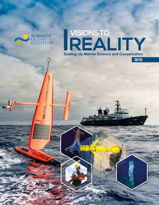
  • 2. COVER Main Image: In early March (two months before Falkor departed for the same mission), two saildrones were deployed from San Francisco to be a part of the "Voyage to the White Shark Café" expedition.They transmitted data in real-time since their departure, listening for the acoustic tags that were attached to sharks, while also scanning with a sonar to detect the deep scattering layer. Hexagon 1: A cirrate octopus has ear-like fins that they use for propulsion. Hexagon 2: Dr. Camilli directs the delicate deployment of a glider from Falkor's aft deck. Hexagon 3: A tall chimney in a new hydrothermal vent field discovered in 2018. Hexagon 4: Trent Lukaczyk prepares a Flightwave Edge for a test flight from the storage deck of the R/V Falkor. THIS PAGE Researchers and ship crew inspect an AUV at the beginning of the "Pescadero Vent" expedition. 2018 VISIONSTO REALITY VISIONSTO REALITY 2018 VISIONSTO REALITY VISIONSTO REALITY
  • 3.
  • 4. 2 REPORT 2018 2018 ANNUAL REPORT ANNUAL REPORT 7 Visions coming true 29 Artificial Intelligence and cloud data analytics acccelerate marine science 55 Artistic endeavors 12 Numbers and metrics (2013-2018) 35 Scaling up marine conservation with technical innovation 58 A step ahead: Improvements & developments Table of CONTENTS FALKOR Above: 3D Overview of the proposed Indy Maru Seamount feature with both the summit and deepest location highlighted [CARIS] [Indy Maru Seamount Supporting Image 005.tif] Above: Profile line through both the shallowest and deepest point of the proposed Indy Maru Seamount. [Fladermaus] [Indy Maru Seamount Supporting Image 006.tif] Table 5.0 – Profile line intersecting the shallowest and deepest point of the proposed Indy Maru Seamount Length Start End Shallowest Point Deepest Point Total Relief Profile Line Shallow to Deep 10306m N 12 07.251, E 134 45.395 N 12 02.040, E 134 47.459 1974m 12 04.708669 N 134 46.375966 E 3546m 12 02.2758561 N 134 47.448084 E 1482m Max Depth 3546m 12 02.2758561 N 134 47.448084 E Min Depth 1974m 12 04.708669 N 134 46.375966 E North START END 3546m 12 02.2758561 N 134 47.448084 E 1974m 12 04.708669 N 134 46.375966 E Start End North FALKOR ROV SUBASTIAN High Performance Computing Installed Graphics Processing Unit power to Falkor's High Performance Computer system to support scientists' and researchers' new emerging technologies. A research vessel first! Cybersecurity & Falkor’s Network Enrollment Redesigned the enrollment process for wireless and wired networks through implementation of a sophisticated software system that protects the entire network from unauthorized computers or users. Ship-to-Shore Video Enhancements By using the core video matrix and cutting edge audio distribution Falkor crewmembers can now route real-time events to the encoders and push them straight to the internet over the satellite connection. Advanced Shipboard Monitoring All shipboard network devices are in constant 24/7 monitoring, from servers to the HVAC systems. New network sensors were added to ensure proper functionality of shipboard critical systems. Soon all devices aboard Falkor will send problem alerts to shoreside technical teams. Faster Internet Commissioned hardware and software aboard Falkor for using 4G data service up to 25 nautical miles offshore; speed rates are now up to 160 Mbps. The new shipboard system uses four internal modems to the packages between the modems and service providers. A research vessel first! FALKOR AUDIO VISUAL / INFORMATION TECHNOLOGY / ELECTRONICS Remote Operation of ROV SuBastian Designed and tested in-house architecture allowing control of SuBastian tethered to Falkor from a land-based operating station. Seafloor Stereo Imagery Capability SOI's engineers developed a photomosaicing skid mounted under SuBastian to collect high resolution stereo-imagery of the seafloor around seeps, vents, and whale falls. This skid utilizes SuBastian's new automated line following capability to combine these image sets into detailed 3D and 2D models for interactive research and analysis of the seafloor. Better Vehicle Control Added new waypoint execution mode for much tighter line following and control over the speed at which waypoints are executed. Operational Procedures Added new operational procedures to maximize ship time and dive efficiencies working simultaneously with AUVs using reconnaissance mapping to pinpoint subsea targets, and directing the ROV to key study sites. More Power Options Installed a science transformer to allow researchers' instruments to have a greater power range for sensor integration (i.e. 110v - 220v) and added voltage regulators to provide lower voltage range (i.e 5v, 6v, 12v & 24v). Equipment Expanded growing inventory of scientific instrumentation, including the integration of 19 new pieces of equipment onto SuBastain on a single dive. Catenary Float Rack For Umbilical Falkor's Engine Department fabricated a float rack for the Aft Deck to allow for a more ergonomic, safe and efficient method of stowing and installing the floats during vehicle deployment and recovery operations. Main Engines Performed major overhaul of 14 cylinder heads. Port Main Engine Clutch Conducted major overhaul. Sea Water Cooler Replaced all of the cooler plates. Emergency Generator Implemented upgrades to increase main buss capacity and the supply air ventilation fan capacity. FALKOR ENGINEERING DEPARTMENT ROV Event Logger Developed software logging system to track vehicle technical and scientific operations as well as scientific ROV operations, allowing for easy annotation, time stamping and geo stamping of ROV science events. Online access to this information allows review by shoreside collaborators and staff. Irradiance Sensors Falkor's suite of sunlight sensors were relocated and expanded, allowing for better exposure to the sky and the collection of important new data. Data are saved in a repository allowing their use by scientists around the globe and providing historical data for future studies. FALKOR SCIENCE DEPARTMENT Falkor sails at sunset in Hawaiian waters. 4 SCALABLE OCEAN RESEARCH WITH AUTONOMUS ROBOTS ACCELERATE MARINE SCIENCE ARTIFICIAL INTELLIGENCE AND CLOUD DATA ANALYTICS ARTISTIC ENDEAVORS SCALING UP MARINE CONSERVATION WITH TECHNICAL INNOVATION SCALABLE OCEAN RESEARCH WITH AUTONOMUS ROBOTS ACCELERATE MARINE SCIENCE ARTIFICIAL INTELLIGENCE AND CLOUD DATA ANALYTICS AND SEAFLOOR HABITATS DIGITIZING MARINE LIFE ANDSHARING INSPIRING ARTISTIC ENDEAVORS SCALING UP MARINE CONSERVAT TECHNICAL INN SCALABLE OCEAN RESEARCH WITH AUTONOMUS RO ACCELERATE MARINE SCIENCE ARTIFICIAL INTELLIGENCE AND CLOUD DATA A AND SEAFLOOR HABITATS DIGITIZING MAR ANDSHARING INSPIRING ARTISTIC ENDEAVORS
  • 5. 201 2018 VISIONSTO REALITY VISIONSTO REALITY 21 Scalable ocean research with autonomus robots 14 Where we have been 2018 Map 43 Digitalizing marine life and seafloor habitats 60 Noteworthy updates 40 What we found 2013-2018 16 Making waves 2018 Hightlights 48 Inspiring and sharing 62 Scientific publications and presentations 2018 26 A working platform 53 Front and center 67 Photo credits 68 Collaborators LKOR 06 07 09 Above: 3D Overview of the proposed Indy Maru Seamount feature with both the summit and deepest location highlighted [CARIS] [Indy Maru Seamount Supporting Image 005.tif] Above: Profile line through both the shallowest and deepest point of the proposed Indy Maru Seamount. [Fladermaus] [Indy Maru Seamount Supporting Image 006.tif] Table 5.0 – Profile line intersecting the shallowest and deepest point of the proposed Indy Maru Seamount Length Start End Shallowest Point Deepest Point Total Relief Profile Line Shallow to Deep 10306m N 12 07.251, E 134 45.395 N 12 02.040, E 134 47.459 1974m 12 04.708669 N 134 46.375966 E 3546m 12 02.2758561 N 134 47.448084 E 1482m Max Depth 3546m 12 02.2758561 N 134 47.448084 E Min Depth 1974m 12 04.708669 N 134 46.375966 E North START END 3546m 12 02.2758561 N 134 47.448084 E 1974m 12 04.708669 N 134 46.375966 E Start End North FALKOR 06 09 Above: 3D Overview of the proposed Indy Maru Seamount feature with both the summit and deepest location highlighted [CARIS] [Indy Maru Seamount Supporting Image 005.tif] Above: Profile line through both the shallowest and deepest point of the proposed Indy Maru Seamount. [Fladermaus] [Indy Maru Seamount Supporting Image 006.tif] Table 5.0 – Profile line intersecting the shallowest and deepest point of the proposed Indy Maru Seamount Length Start End Shallowest Point Deepest Point Total Relief Profile Line Shallow to Deep 10306m N 12 07.251, E 134 45.395 N 12 02.040, E 134 47.459 1974m 12 04.708669 N 134 46.375966 E 3546m 12 02.2758561 N 134 47.448084 E 1482m Max Depth 3546m 12 02.2758561 N 134 47.448084 E Min Depth 1974m 12 04.708669 N 134 46.375966 E North START END 3546m 12 02.2758561 N 134 47.448084 E 1974m 12 04.708669 N 134 46.375966 E Start End North 5 SCALING UP MARINE CONSERVATION WITH TECHNICAL INNOVATION SCALABLE OCEAN RESEARCH WITH AUTONOMUS ROBOTS ACCELERATE MARINE SCIENCE ARTIFICIAL INTELLIGENCE AND CLOUD DATA ANALYTICS AND SEAFLOOR HABITATS DIGITIZING MARINE LIFE ANDSHARING INSPIRING ARTISTIC ENDEAVORS SCALING UP MARINE CONSERVATION WITH TECHNICAL INNOVATION SCALABLE OCEAN RESEARCH WITH AUTONOMUS ROBOTS ACCELERATE MARINE SCIENCE ARTIFICIAL INTELLIGENCE AND CLOUD DATA ANALYTICS AND SEAFLOOR HABITATS DIGITIZING MARINE LIFE ANDSHARING INSPIRING ARTISTIC ENDEAVORS SCALING UP MARINE CONSERVATION WITH TECHNICAL INNOVATION SCALABLE OCEAN RESEARCH WITH AUTONOMUS ROBOTS ACCELERATE MARINE SCIENCE ARTIFICIAL INTELLIGENCE AND CLOUD DATA ANALYTICS AND SEAFLOOR HABITATS DIGITIZING MARINE LIFE ANDSHARING INSPIRING ARTISTIC ENDEAVORS
  • 6. 2 REPORT 2018 2018 ANNUAL REPORT ANNUAL REPORT John Ryan and Brian Kieft, of Monterey Bay Aquarium Research Institute (MBARI), and Gabe Foreman, of University of Hawaii Manoa, guide LRAUV Opah off R/V Falkor's aft deck during the autonomous robot's deployment. 6
  • 7. 201 2018 VISIONSTO REALITY VISIONSTO REALITY VISIONS COMING TRUE Artificial Intelligence and Robotics Begin to Transform Ocean Conservation and Research The ocean gives life. It is no surprise that the abundance of liquid water is the principal habitability criterion in astrobiology. From the earliest emergence of life on Earth, the ocean has played a crucial part in sustaining it. For millennia, the seas have produced most of the oxygen we breathe, regulated our weather, and supplied critical nutrients and resources - despite the global disturbances from human activity in the recent decades. Rapid ocean warming, acidification, deoxygenation, pollution, and overexploitation push marine life to the edge of survival. More than a quarter of all known oceanic species are losing a place to call home. Global scale and furious rate of change call for dramatic acceleration in our ability to understand, foresee, and avert their harmful effects. The developments in robotics, artificial intelligence (AI), and other technology frontiers can offer effective tools to accelerate ocean research, conservation, and management at scale. Established nearly a decade ago to advance ocean research with innovation, Schmidt Ocean Institute completed its busiest and most productive year in 2018. Research vessel Falkor spent 243 days at sea supporting 11 select research projects, including 135 days with remotely operated vehicle SuBastian onboard. At SOI, we are gearing up for the future, and the new ways oceanography will be done. We are always excited and curious to see what scientists who conduct research on board Falkor will come up with, and how, together, we can push the existing boundaries of marine research. - Wendy Schmidt. These are all records for SOI. However, what hides behind these numbers is the true impact of the program. In this report, we discuss a series of transformative innovations demonstrated by SOI in 2018 to illustrate how we can scale our capacity to understand and better conserve our ocean. One example of this transformation took place in February when two Saildrones, unmanned surface wind and solar powered vehicles, were launched to the White Shark Café to study why this remote area attracts white sharks. Traversing thousands of miles halfway between Hawaii and California, Saildrones surveyed the region for a month ahead of Falkor’s arrival. Their early entrance informed the scientific sampling plans, gathering rich sensor data that showed how small-scale eddies draw nutrients closer to the surface to enhance biological production; a good reason why the sharks may be drawn to this area. Following the expedition, the Saildrones duties were extended to track an oceanic front for SOI’s next project a couple thousand miles away. These examples show how the Saildrones can be applied to future seagoing oceanography, where operational flexibility, endurance, low environmental impact, and excellent observational data can reduce operational costs and risks. This shift will make critical elements of marine field science accessible to oceanographic researchers around the world. Co-founders Eric and Wendy Schmidt. 7
  • 8. 2 REPORT 2018 2018 ANNUAL REPORT ANNUAL REPORT Several projects this year focused on developing AI and machine learning tools to support marine science and management in near real time. In January, teams from Massachusetts Institute of Technology (MIT) and University of Sydney tested artificial intelligence (AI) -based multi-vehicle ocean survey software from aboard Falkor using SOI’s high performance computer. The model was analyzed to inform real time planning of operations to collect valuable data as the survey progressed. SOI, in collaboration with the University of Porto, also developed Ocean Space Center software that was used in May to automatically guide dozens of aerial, surface, and submarine robots as they mapped the dynamic subtropical pacific ocean front in high resolution and 3D. The advanced software managed successful multi- robotic ocean surveys while requiring only one human observer in Falkor’s science control room. In July, teams from the Universities of Southampton and Tokyo, compiled the largest known centimeter-resolution color 3D map of deep seafloor from 1.3 million photos acquired on site at Hydrate Ridge off the coast of Oregon. They used unsupervised machine learning at sea to quickly find the areas of scientific interest and study rapidly changing seafloor that would otherwise be virtually impossible to find and sample within the cruise timeframe. Duringthefinalexpeditionoftheyear,Falkorhostedateamofroboticists developing advanced AI for autonomous planetary exploration in deep space that will tolerate large communications latencies. The researchers tested non-deterministic ocean surveying, where robots could "locate gas seeps", "find rock formations", and "survey biological hotspots" without being explicitly programmed to do so and by having to learn the specifics of such tasks from diverse ocean data and expert annotations. In a successful demo, 11,000 square miles of ocean were intelligently surveyed within nine days. Highlighted by these projects, AI and machine learning are on the path to become indispensable for the future of oceanography. With these unique journeys of discovery and development, SOI continues to bring the ocean to people in their communities, schools, workplaces, and recreation groups. With these unique journeys of discovery and development, SOI continues to bring the ocean to people in their communities, schools, workplaces, and recreation groups. High-resolution imagery from ROV SuBastian has been viewed in real time on our YouTube channel by more than half a million people and featured in 15 documentaries this year. New collaborations with the Smithsonian Museum and Aquarium of the Pacific have allowed us to connect scientists with greater numbers of people on shore. Dr. Blair Thornton guides one of ROV SuBastian's dives during the "Adaptive Robotics" expedition in R/V Falkor's control room, using the maps and images acquired by the AUVs and processed by unsupervised algorithms. The expedition used a suite of AUVs with different mapping capabilities and specialties to gather the bathymetry data for the experimental Artificial Intelligence software to decipher. 8
  • 9. 201 2018 VISIONSTO REALITY VISIONSTO REALITY And SOI helps to make Falkor-related scientific articles open access so anyone can read the details from research done at sea. 2018 was a remarkably productive year for science, and for sharing the joy and excitement of our discoveries and achievements. This is just one of the reasons SOI was named by Marine Technology Reporter as one of the Top 10 Ocean Influencers. This year our report is organized by themes that are building a foundation of success for the future. Readers will find details on how we are contributing to the arts, advancing ROV SuBastian’s capabilities, sharing our incredible footage, and connecting with the public. We hope you will be inspired as much as we have been by our supported projects and research teams, technical innovations, and wondrous marine discoveries that have marked 2018. Crew of the "Pescadero Vent" expedition recover the mapping AUV D. Allan B. This autonomous underwater vehicle is equipped with four mapping sonars that operate simultaneously during a mission: a swath multibeam sonar, two sidescan sonars, and a sub-bottom profiler. The multibeam sonar produces high-resolution bathymetry (analogous to topography on land), the sidescan sonars produce imagery based on the intensity of the sound energy’s reflections, and the sub-bottom profiler penetrates sediments on the seafloor, allowing the detection of layers within the sediments, faults, and depth to the basement rock. 9
  • 10. AE2000f was the "Adaptive Robotics" expedition's scout. It would cruise at about 20km/h, collecting preliminary images of the seafloor: this data was then used to determine where the rest of the robots should focus their efforts. 10 REPORT ANNUAL REPORT
  • 12. FALKOR 350 K Km traveled. A Distance Greater Than Circling the Globe 9 Times ROV SUBASTIAN 324 ROV Dives 737 ROV Samples Collected 497 Hrs livestreamed on YouTube 1,176 Science Days 752 Scientists from 165 Institutions in 30 Countries 304 AUV Dives 36 UAVs Launched Totaling 31.3 Hours 1,231 CTD Casts261 Students x9 2013-2018 NUMBERS AND METRICS 12 2 REPORT 2018 2018 ANNUAL REPORT ANNUAL REPORT
  • 13. ARTIST-AT-SEA 2018 DATA GB Falkor and SuBastian Data Downloaded from MGDS 763 74TB of Data KM2 of Falkor Mapping Data Merged into GMRT since 2012 573,590 DAYS OF DATA Sent to SAMOS 203 DATA FILES Downloaded from MGDS 7, 326Sent to and Quality Processed by SAMOS 272,160 REPORTS People on Facebook 1 million+ 2018 SOCIAL MEDIA 2018 OUTREACH 128 BLOGS 121 EXPEDITION VIDEOS 1,716,000 MINUTES of YouTube Video Watched 38 DOCUMENTARIES AND EXHIBITS Using SOI footage 2,741 PEOPLE REACHED Through Community Presentations 1,000 PEOPLE WELCOMED onto Falkor for Tours 531,460 Used the SOI Website Created through the Program 99 PIECES OF ARTWORK 21 ARTISTS 14 EXHIBITS in 10 Different Cities 90 LIVE SHIP TO SHORE CONNECTIONS Viewed By 8,187 People on YouTube, 51% Increase from 2017 528,475 VIEWS REACHED Impressions on Twitter 1,990,900 Instagram Likes 20,308 13 201 2018 VISIONSTO REALITY VISIONSTO REALITY
  • 14. Number: FK180722 Location: San Diego to Astoria, United States Date: July - August The Seeping Cascadia Margin Coordinated Robotics: ʻAuʻAu Channel Number: FK180119 Location: Honolulu, United States Date: January - February 01 02 Number: FK180420 Location: Honolulu to San Diego, United States Date: April - May Exploring Fronts with Multiple Robots Number: FK180528 Location: San Diego, United States Date: June Solving Microbial Mysteries with Autonomous Technology Number: FK190624 Location: San Diego, United States Date: June - July Voyage to the White Shark Café Adaptive Robotics at Barkley Canyon & Hydrate Ridge Number: Fk180731 Location: Astoria, United States Date: August Eddy Exploration and Ecosystem Dynamics Number: FK180310 Location: Honolulu, United States Date: March - April Number: FK190824 Location: Astoria to San Francisco, United States Date: August - September 03 04 05 06 07 Characterizing Venting and Seepage Along the California Coast Number: FK181005 Location: San Francisco to San Diego, United States Date: October Interdisciplinary Investigation of a New Hydrothermal Vent Field Number: FK181031 Location: San Diego, United States to Manzanillo, Mexico Date: November New Approaches To Autonomous Exploration At The Costa Rican Shelf Break Number: FK181210 Location: Puntarenas, Costa Rica Date: December 08 09 10 11 Hunting Bubbles: Understanding Plumes of Seafloor Methane Conducted research in Mexican waters working closely with the U.S. Embassy in Mexico City. Hosted a foreign observer from the Deputy General Directorate of Oceanography, Hydrography and Meteorology onboard Falkor for the cruise and will be sharing the expedition data with local scientific agencies. Hosted tours on Falkor for several Costa Rican dignitaries and U.S. Embassy affiliates in San Jose. WHERE we have been The deep ocean is still one of the least explored frontiers in the solar system. Maps of our planet are not as detailed as those of Mercury, Venus, Mars or the Moon, because it is hard to map underwater. This is the frontier. - Robert Zierenberg, Principal Investigator. 14 2 REPORT 2018 2018 ANNUAL REPORT ANNUAL REPORT
  • 16. 2 REPORT 2018 2018 ANNUAL REPORT ANNUAL REPORT MAKING WAVES 2018 Highlights Coordinated Robotics 2, Hawaii Eddy Exploration & Ecosystem Dynamics, Hawaii Voyage to the White Shark Cafe, California Improved marine surveys by teaching robots to collaborate and share knowledge Achieved the longest deployment of Environmental Sampling Processors on Long Range AUVs Protected white sharks with Saildrones and shipboard eDNA Demonstrated from aboard Falkor coordinated operations and data-driven site selection with multiple autonomous underwater vehicles. Refining techniques using several vehicles will make habitat mapping simpler and easier for a more scalable approach that can present follow-on benefits for management and policy-making. Completed the first open ocean deployment of long range autonomous underwater vehicles (LRAUVs); they are the only AUVs that can survey filtered seawater insitu and allow for sampling in remote or dangerous locations. Seawater collected with the LRAUVs is being sequenced to determine microbial communities found at the ocean surface, this is important baseline information to have as seawater temperatures increase. Documented the oceanographic conditions and biological productivity of a white shark congregation zone. This was achieved with a multi-platform sampling program coupling Falkor, SuBastian, and two Saildrone autonomous surface vehicles, gathering crucial ocean currents and animal density data. The data will illuminate this little-studied ecosystem and contribute to the conservation efforts of the high seas. Prof. Williams and Dr. Lachlan Toohey continue their work with the NextGen vehicle, long after dark. 1616
  • 17. 201 2018 VISIONSTO REALITY VISIONSTO REALITY Exploring Fronts with Multiple Robots, California Solving Microbial Mysteries, California The Seeping Cascadia Margin, Oregon Located and mapped a Pacific subtropical ocean front using a coordinated fleet of robots Tested in situ microbial incubators to understand how marine life adapts to oxygen depletion in the ocean Reached non-science audiences with artistic visualization of marine data Tracked, mapped, and sampled a mesoscale filament of a major ocean front with multiple autonomous underwater, surface, and aerial vehicles using open-source communication. The technologies represent an important step towards achieving the levels of persistence, spatial and temporal resolution, as well as coverage, required for ocean studies in a changing climate. Tested and refined an autonomous in situ incubation device allowing shipboard scientists near-continuous monitoring in an oxygen deficient ocean system. The seawater incubations will provide better insight into how microbes interact with each other and their chemical environment. The refinements in low oxygen marine system operations will help scientists better understand the ocean’s role in moderating climatic changes. Created detailed mid-water and seafloor maps in an unsurveyed methane seep region with six artists and two Student Opportunities participants. The maps will be used to identify where hydrocarbon seeps are occurring and their flow activity for future observation and research. The artists captured the mapping work of Falkor’s shipboard marine technicians with striking art forms including a light painting performance, oceanscape resin art, woodworking sculpture, portrait painting, cyanotype prints, and a life-size mural of the Pseudoliparis swirei ghost fish. Chief Scientist Andrew Babbin examines the in-situ incubators. 17
  • 18. 2 REPORT 2018 2018 ANNUAL REPORT ANNUAL REPORT Adaptive Robotics at Hydrate Ridge, OregonHunting Bubbles: Understanding Plumes of Seafloor Methane, Oregon Characterizing Venting and Seeping, California Revealed new sites and species in the California Borderland Developed new ways to understand ocean cycles via methane bubbles Guided exploration and research of changing seafloor habitats with AI Gained insight into the role of gas vents and seeps in the ecology of the Southern California Borderland, using ROV SuBastian and the advanced seafloor observatory (ABISS). The ABISS lander deployments showed that methane venting is more episodic than previously known, which changes assumptions about methane escape from the seafloor to the atmosphere. The science team is producing a map of the contiguous seeps and analyzing the relationships among the animals, including potentially new species, to understand the connectivity of these habitats. Installed a novel bubble capture system on ROV SuBastian to take chemical measurements of bubble composition and gather data on the chemical dynamics of bubbles. The development of this equipment (and cutting-edge sensors) is important in illustrating changes in methane from venting locations across a spatial scale and over time. The large flux of this methane into the ocean may indirectly play an important part in the carbon cycle, which is closely linked to Earth’s climate. Used unsupervised learning techniques with 3D reconstruction pipelines to analyze imagery collected between AUV deployments. As a result, the largest known continuous photogrammetric reconstruction of seafloor mapped at sub-centimeter resolution was created, including an 11.4 hectare dense 3D image reconstruction. Developing end-to-end autonomy is critical to scale robotic operations so that hundreds may be deployed simultaneously in the future, giving scientists the ability to monitor larger areas and understand the ocean more efficiently. Dr. Scott Wankel preparing the mass spectrometer that will live on SuBastian during the next month - giving near real time continual measurements of methane. 18
  • 19. 201 2018 VISIONSTO REALITY VISIONSTO REALITY Interdisciplinary Investigation of a New Hydrothermal Vent Field, Mexico New Approaches to Autonomous Exploration, Costa Rica Conducted centimeter-scale AUV survey of hydrothermal vents in Pescadero Basin Tested AI-driven robots for a possible extraterrestrial mission Doubled viewership of incredible 4K deep-sea imagery from ROV SuBastian. This resulted in the use of footage in documentaries, television, and museum exhibits at the Dundee Heritage Trust, and Barbican Museum. We also hosted public ship tour days during US port calls, bringing more than 1,000 people on board. Additionally, SOI continued our traveling Artist-at-Sea exhibit showcasing 11 new artists at venues including Aquarium of the Pacific, Exploratorium, and the NOAA Exploration Forum. The works incorporate data collected during expeditions and have been used for outreach by the scientists as well. Broadened participation in ocean sciences Completed centimeter scale resolution mapping resulting in the discovery of a new vent field (JaichMaat). The list of species occurrences for the area was significantly expanded and the team collected several animals that may represent new species. The discovered site is an important location to try to understand how vent fauna colonize, evolve, and speciate. Operated multiple self-controlled robotic vehicles while successfully developing AI for autonomous exploration and research of remote uncharted environments. This technology will support future oceanographic and planetary exploration, where due to communications latencies robots routinely need to make tactical decisions without human intervention. Richard Camilli, Principal Investigator of the "New Approaches To Autonomous Exploration At The Costa Rican Shelf Break" and David Pinga assemble a Sloucm glider in R/V Falkor's wet lab. 19
  • 20. The autonomous vehicles - aerial and underwater - utilized by the Ocean Robots Team line the aft deck of R/V Falkor. The challenge is trying to do as much as we can to help people make sensibledecisions.Havingmoreocean observationsiscriticaltogoodscience and providing a comprehensive view of what is happening, and how things are changing. This will build our ability to understand the ocean, and to make wiser decisions and policies in the future. - Oscar Pizarro, Principal Investigator. 20
  • 21. ARTISTIC SCALABLE OCEAN RESEARCH WITH ENDEAVORS AUTONOMUS ROBOTS ARTIFICIAL INTELLIGENCE AND 21
  • 22. DATA-DRIVEN CORAL REEF SURVEYS WITH COORDINATED ROBOTIC TEAMS SCALABLE OCEAN RESEARCH with Autonomous Robots The ocean is too large to observe with conventional means. SOI recognizes that in order to make meaningful advances there must be more agile, resilient, and robust platforms. Robots and AI can greatly improve coverage and cost-efficiency for select ocean observations by reducing risk, and facilitating high resolution spatially distributed surveys of dynamic marine processes, as illustrated by the projects discussed in this section. In January, SOI welcomed Dr. Oscar Pizarro, Australian Centre for Field Robotics (ACFR), and his collaborators from MIT and the University of Sydney back aboard Falkor to research and demonstrate multi-robotic surveys of coral reefs. As part of this project, SOI supported the development and testing of data-driven planning algorithms for autonomous marine surveys completed by heterogeneous robots. Thiswasillustratedbyrunningaconsolidated model of a coral reef (in the ‘Au’Au channel off Maui, HI) on Falkor’s high performance computer that was continuously updated with new data gathered by the robotic systems. As each vehicle transmitted fresh observational data to the common model, the software algorithms updated the estimates of uncertainty for each feature of scientific interest. This resulted in identified locations and parameters to be surveyed next by each vehicle, taking in account their operational status, positions, and sensing capabilities. The coordinated robots collected over half a million georeferenced images covering 77,453 square meters of seafloor. “The challenge is trying to do as much as we can to help people make sensible decisions,” said Dr. Pizarro. “This expedition was an opportunity to try techniques that automate science plans. Having more ocean observations is critical to good science and providing a comprehensive view of what is happening, and how things are changing. This will build our ability to understand the ocean, and to make wiser decisions and policies in the future.” georeferenced images along the the 'Au'Au Channel covering 77,453 m2 of seafloor COLLECTED MORE THAN 500,000 Researchers work on a programming and optimizing an Iver autonomous vehicles in Falkor's Wet Lab. 22 SCALING UP MARINE CONSERVATION WITH TECHNICAL INNOVATION SCALABLE OCEAN RESEARCH WITH AUTONOMUS ROBOTS ACCELERATE MARINE SCIENCE ARTIFICIAL INTELLIGENCE AND CLOUD DATA ANALYTICS AND SEAFLOOR HABITATS DIGITIZING MARINE LIFE ANDSHARING INSPIRING ENDEAVORS
  • 23. georeferenced images along the the 'Au'Au Channel covering 77,453 m2 of seafloor COLLECTED MORE THAN 500,000 data stations 80 300 m LRAUVs sample to depths of with an operational range of 1,000 km CTD casts 28 shark satellite pop-up tags recovered 10 yielding 70+ hours of midwater observations in habitat never before surveyed 9 SuBastian Dive ADAPTIVE MICROBIAL SAMPLING OF OCEANIC EDDIES WITH LONG RANGE AUVS The second Falkor expedition of the year was led by Drs. Sam Wilson and Steve Poulos, University of Hawaii, in collaboration with the Monterey Bay Aquarium Research Institute (MBARI), giving way to the first- ever open ocean deployment, microbial sampling, and insitu data analysis by long range autonomous underwater vehicles (LRAUVs). The LRAUVs are a great engineering feat that enable ocean observation and sampling in remote locations. Deploying multiple LRAUVs simultaneously allowed the research team aboard Falkor to adaptively sample a moving ocean eddy field. This research set a new record for the duration of this type of mission, and characterized in unprecedented detail microbial communities found in eddy fields. The vehicles captured and analyzed environmental samples in situ while being able to amend and guide their own sampling patterns based on onboard data analyses. The three LRAUVs were fitted with next generation Environmental Sample Processors (ESPs) and other sensors to monitor seawater parameters and identify hydrographic features that are likely to host interesting microbial processes. The results were stunning, never before in microbial oceanography have researchers been able to sample the open ocean deep chlorophyll maximum and other parameters with this level of precision. The vehicles offer a novel perspective of these common yet poorly understood oceanic microbial processes. Seawater collected with the LRAUVs is being sequenced and analyzed to determine the structure and composition of the resident marine microbial communities. The samples will help tell us how marine microbes interact with each other in space and time. LRAUVs were programmed with missions to detect features inside eddys. When a feature is discovered, the LRAUVs lock in and can track the feature for days at a time. We need to understand these microscale processes in order to comprehend bigger processes such as carbon cycling across the global ocean basins. Researchers prepare to launch a LRAUV from Falkor's midship. 23 20120182018201820182018 VISIONSTO REALITY VISIONSTO REALITY VISIONSTO REALITY VISIONSTO REALITY VISIONSTO REALITY VISIONSTO REALITY
  • 24. georeferenced images along the the 'Au'Au Channel covering 77,453 m2 of seafloor COLLECTED MORE THAN 500,000 data stations 80 300 m LRAUVs sample to depths of with an operational range of 1,000 km CTD casts 28 shark satellite pop-up tags recovered 10 yielding 70+ hours of midwater observations in habitat never before surveyed 9 SuBastian Dives MID-OCEAN RESEARCH AND MONITORING OF WHITE SHARKS WITH SAILDRONES Science on Falkor was guided for the first time by two sensor-laden Saildrones, autonomous surface vehicles with unlimited range and endurance. These long-range vehicles were launched from San Francisco Bay, reaching the White Shark Café a month ahead of Falkor’s arrival to characterize oceanographic conditions, currents, and animal densities in the open ocean region halfway between Hawaii and the Baja California Peninsula. The data gathered was critical for the shipboard research team to accurately identify the white shark congregation area that was later studied with Falkor and SuBastian. Dr. Barbara Block, Stanford University, and her international team, led this study to understand why this remote and desolate area attracts massive-sized white sharks each year. A greater understanding of this otherwise unknown habitat for sharks was achieved with a multi-platform sampling program coupling Falkor with shore- launched robotic vehicles working in tandem. The shipboard team was able to locate all shark tags that were deployed in the previous fall off the coast of California. Scientific observations, data collection, and sample analysis, including shipboard eDNA sequencing, continued on Falkor. The data provided important new insights into the habitat and white shark behavior. For instance, Saildrone data showed how small-scale ocean eddies draw nutrients closer to the surface, enhancing biological production, which could make this region more appealing for sharks. This finding offered a valuable head start to the scientists in addressing the key questions of their study. “We have doubled the current 20-year data set on white shark diving behaviors and environmental preferences in just three weeks using tools that provided a rapid census of the predators and prey of a remote ocean region,” said Dr. Block. “This helps establish observations that will allow for better understanding of this environment and why it attracts large predators.” Main Image: PhD candidate Elizabeth Andruszkiewicz, Dr. Nathan Truelove and PI Dr. Barbara Block celebrate having successfully isolated DNA from the first CTD cast. The results are positive for vertebrates - including sharks. Detail Image: This is a pop-up satellite archival tag used on the sharks - it has a light sensor, a temperature sensor, a pressure sensor, and a very accurate clock. It goes on the white shark, the shark carries the tag, and then at a point chose and programmed by the researchers, it pops off. A float takes it to the surface and it sends radio transmissions to Earth orbiting satellites. 24 SCALING UP MARINE CONSERVATION WITH TECHNICAL INNOVATION SCALABLE OCEAN RESEARCH WITH AUTONOMUS ROBOTS ACCELERATE MARINE SCIENCE ARTIFICIAL INTELLIGENCE AND CLOUD DATA ANALYTICS AND SEAFLOOR HABITATS DIGITIZING MARINE LIFE ANDSHARING INSPIRING ENDEAVORS
  • 25. Top Image: Trent Lukaczyk prepares a Flightwave Edge for a test flight from the storage deck of the R/V Falkor. Middle Image: Crew and science team including John Ryan (MBARI), Allan Doyle (Chief officer Falkor), Brian Kieft (MBARI), and Gabe Foreman (of University of Hawaii Manoa) begin to guide LRAUV Opah off R/V Falkor's​ aft deck during the autonomous robot's deployment. Bottom Image: A Flightwave Edge UAV, piloted by Trent Lukaczyk, flies towards R/V Falkor. The Unmanned Aerial Vehicle worked in concert with underwater robotics and the crew onboard the ship gathering data. STRETCHING THE LIMITS OF ROBOTIC AUTONOMY FOR OCEAN SURVEYING While returning to California, the two Saildrones were remotely re-tasked to support a project led by Dr. João de Sousa, University of Porto. The robust multi-vehicle mission used planning and control algorithms to enable real-time analysis of complex ocean dynamics, specifically locating, tracking, and measuring the North Pacific Subtropical Front. This multi-platform approach was completed with many low cost vehicles deployed from Falkor in different mediums, including underwater, surface and air. More than a dozenrobotic systems were deployed and simultaneously operated by an SOI-supported Ocean Space Center software running aboard Falkor, allowing the researchers to map the oceanic feature in high, sub-mesoscale resolution, including space and time. To coordinate the operations of multiple robotic platforms, the team flew unmanned aerial vehicles (UAVs) over the areas of operations to collect oceanographic observations, serving as “mules” to ferry data between distant AUVs and the Falkor. By the end of the expedition, the AUVs traveled over 3,430 kilometers for approximately 500 hours; and the UAVs performed over 25 flawless flights totaling 10 hours. The technologies used on this expedition represent an important step towards achieving the levels of persistence, spatial and temporal resolution, as well as coverage, required for scalable ocean studies in a changing climate . “Oceans are the Earth’s life support system. To be properly taken care of, they need to be characterized with much higher resolution and coverage in time in space than what’s possible with ships,” said Dr. de Sousa. 25 20120182018201820182018 VISIONSTO REALITY VISIONSTO REALITY VISIONSTO REALITY VISIONSTO REALITY VISIONSTO REALITY VISIONSTO REALITY
  • 26. A WORKING PLATFORM VOYAGE TO THE WHITE SHARK CAFÉ EDDY EXPLORATION AND ECOSYSTEM DYNAMICS EXPLORING FRONTS WITH MULTIPLE ROBOTS SOLVING MICROBIAL MYSTERIES WITH AUTONOMOUS TECHNOLOGY SIRIUS AV NEXT GEN AUV IVER 2 LAGRANGIAN FLOAT WAM-V 16’ CATAMARAN ASV AUV IVER 3 SLOCUM GLIDER COORDINATED ROBOTICS: ʻAUʻAU CHANNEL LONG RANGE AUVS (Aku ,Ahi, Opah) SEAGLIDER WAVE GLIDER WIRE WALKER x3 x2 x2 SAILDRONE x2 SAILDRONE x2 VERTICAL TAKE-OFF AND LANDING UAVS UAVS x3 x6 ROV SUBASTIAN A WORKING PLATFORM AUV IVER 2 LIGHT AUVS WAVEGLIDER FREE FLOATING IN-SITU INCUBATORS suspended at depth from a float x2 26 2 REPORT 2018 2018 ANNUAL REPORT ANNUAL REPORT
  • 27. HUNTING BUBBLES: UNDERSTANDING PLUMES OF SEAFLOOR METHANE ROV SUBASTIAN WITH BUBBLE ACCUMULATION CHAMBER JET-YAK ROV SUBASTIAN AE2000F TUNA-SAND TUNA-SAND 2 ADAPTIVE ROBOTICS AT BARKLEY CANYON & HYDRATE RIDGE ABISS LANDER INTERDISCIPLINARY INVESTIGATION OF A NEW HYDROTHERMAL VENT FIELD CHARACTERIZING VENTING AND SEEPAGE ALONG THE CALIFORNIA COAST ROV SUBASTIAN WITH FIRST SUCCESSFUL PHOTOMOSACING SLED ABISS LANDER ROV SUBASTIAN WITH MBARI MAPPING SLED WITH LIDAR IN SITU MASS & LASER SPECTROMETER IN SITU MASS AND LASER SPECTROMETER DIVE # DORADO AUV 27 201 2018 VISIONSTO REALITY VISIONSTO REALITY
  • 28. Chief Scientist Blair Thornton consults the visual map of the seafloor, in order to confirm the location to send ROV SuBastian. It is amazing to see large areas of the seafloor mapped only days after the raw data was collected. It is not just the size of the map, but the way we used it to inform our on-site decisions. This makes a real difference as the technology allowsustovisualizewideareasat high resolution, and select where we should collect data. This has not previously been possible. - Blair Thornton, Principal Investigator. 28
  • 29. ARTISTIC SCALABLE OCEAN RESEARCH WITH ENDEAVORS AUTONOMUS ROBOTS ACCELERATE MARINE SCIENCE ARTIFICIAL INTELLIGENCE AND CLOUD DATA ANALYTICS SCALING UP MARINE CONSERVATION WITH 29
  • 30. ARTIFICIAL INTELLIGENCE and Cloud Data Analytics Accelerate Marine Science SOI-SUPPORTED SCIENTIFIC IMAGE ANNOTATION SOFTWARE BECOMES A NATIONAL STANDARD Ocean observing data is growing at an accelerating pace, however, more is needed to enable well informed, ocean conservation and management. Many conventional workflows for marine data processing in ocean conservation and research are not automated, inhibiting the productivity of researchers and managers. This year SOI focused on projects leveraging the utilization of Falkor and ROV SuBastian that worked towards automating marine data analysis workflows to accelerate the understanding of our rapidly changing marine habitats and multiply the conservation benefits. Squidle+ is a web-based open source software for the annotation of marine scientific images, videos, and photomosaics. SOI has supported the development of this software since 2015 when it was initially deployed as part of a Falkor-hosted R&D project. The near-real-time crowd-sourced annotation of AUV acquired seafloor imagery has been further developed by SOI for shipboard ROV SuBastian annotation and event logging. The enhanced version of Squidle+ has been adopted by the Australian National Environmental Science Program and Japan Agency for Marine Science and Technology as the preferred platform for annotating images. Other government agencies such as Canada’s Department of Fisheries and Oceans and U.S.’s National Oceanic and Atmospheric Administration are exploring using the platform for their image annotation purposes as well. Dr. Richard Camilli directs the deployment of a Slocum glider from Falkor's aft deck off the coast of Costa Rica. 30 SCALING UP MARINE CONSERVATION WITH TECHNICAL INNOVATION AUTONOMUS ROBOTS ACCELERATE MARINE SCIENCE ARTIFICIAL INTELLIGENCE AND CLOUD DATA ANALYTICS AND SEAFLOOR HABITATS DIGITIZING MARINE LIFE ANDSHARING INSPIRING
  • 31. COMPILING AND ANALYSING THE LARGEST KNOWN CENTIMETER-RESOLUTION MODEL OF SEAFLOOR In August, Dr. Blair Thornton, University of Southampton, and his collaborators from the UK and Japan deployed two AUVs from Falkor to acquire 1.3 million seafloor images of changing microbial habitats surrounding methane seeps off the U.S. West Coast. The team used shipboard high performance computers to rapidly compose these images into the largest known centimeter-resolution color 3D model of 11.4 hectares of the seafloor. An unsupervised machine learning algorithm was used to cluster the images by visual similarity and locate continuously changing microbial hotspots on the seafloor. Detailed surveys were conducted using ROV SuBastian the following day. This project demonstrated how throughput data processing and machine learning can multiply the productivity of marine scientists. It allowed the team to make quick and well-informed sampling decisions and conduct fine scale surveys to study habitats that would otherwise be virtually impossible to observe in detail. The resulting composite map was invaluable in planning operations, including the recovery of seafloor instruments, re-visiting active bubble plumes, and made the entire operation more efficient. Using AI, scientists have the ability to gather data and make decisions in expedition relevant time frames, prompting better use of the robotic systems deployed at sea. A) 3D photogrammetric reconstruction of the Southern Hydrates Ridge (depth 780 m) that was generated by the AUV Ae2000f. The mapped area covers 11.8 ha at an average resolution of 6 mm and is the largest known expanse of seafloor that has been visually mapped in colour. The Falkor shown to scale in the top left of the panel. B) Outputs of an unsupervised classifier that was used to analyze the imagery between deployments and generated information summaries such as the image class matrix E). C) White bacterial mat that was identified by the classifier, which was subsequently surveyed by the AUV Tuna-sand at sub-millimeter resolution to gather more detailed information. The arrow in C) illustrates the direction from which the isometric view of the reconstruction is viewed in D). 31 2012018201820182018 VISIONSTO REALITY VISIONSTO REALITY VISIONSTO REALITY VISIONSTO REALITY VISIONSTO REALITY
  • 32. Falkor’s last expedition of 2018 hosted specialized teams, including computer scientists, roboticists, and oceanographic researchers from Woods Hole Oceanographic Institution (WHOI), MIT, NASA, ACFR, and the University of Michigan. The groups worked together, developing advanced AI for autonomous robotic exploration of remote uncharted environments. This technology will support future planetary exploration in space and in deep sea habitats, where due to communications latencies, robots need to make tactical decisions without human intervention. TEACHING ROBOTS TO LEARN FROM DATA TO PLAN AND EXECUTE OCEAN SURVEYS Left Image: Navigator Officer Marissa Judkins is part of the team performing final checks before launching TUNA-SAND. With its systems and navigation capabilities tested and confirmed, it is ready to begin work at the sea floor. Ultimately, our goal is to use what we have learned to inform the design of fully autonomous robots that will one day explore the oceans of Europa and Enceladus. - Richard Camili, Principal Investigator. 32 SCALING UP MARINE CONSERVATION WITH TECHNICAL INNOVATION AUTONOMUS ROBOTS ACCELERATE MARINE SCIENCE ARTIFICIAL INTELLIGENCE AND CLOUD DATA ANALYTICS AND SEAFLOOR HABITATS DIGITIZING MARINE LIFE ANDSHARING INSPIRING
  • 33. Top Image: Richard Camilli, Principal Investigator of the "New Approaches To Autonomous Exploration At The Costa Rican Shelf Break" and David Pinga assemble a Sloucm glider in R/V Falkor's wet lab. Hexagon 1: Technicians Tetsu Koike and Kazunori Nagano work on the camera load onboard AE200f, which is advancing visual recordings made while exploring the ocean floor. Hexagon 2: ROV pilot Jason Rodriguez wears eye detection glasses, which record his eye motions and focus, as part of the data that will be used to train robotic algorithms. One of the developed science software tools, the AI/machine learning-based autonomous planner "Spock," was tested aboard Falkor in December. Deployed on the high performance computer, “Spock” parsed large volumes of diverse marine data from the ship’s and robots’ instruments, earlier surveys, and scientific annotations to suggest what new sites may be of potential interest for scientific surveys. Instead of traditional localization programming to avoid hazards, “Spock” let the shipboard researchers task the robots at much higher levels by simply asking them to “locate gas seeps”, “find rock formations”, or “survey biological hotspots.” All other mission details such as where to look for such features and how to survey them with available sensors were determined by AI. The researchers led by Dr. Richard Camilli were fascinated to see the robotic systems demonstrating the ability to find and map rocky outcrops and biological hotspots without being directed where to search. Rapid, AI-driven data analysis more than doubled the utilization of robots during this expedition and allowed the researchers to survey 28,490 square kilometers of ocean within only nine days. 33 2012018201820182018 VISIONSTO REALITY VISIONSTO REALITY VISIONSTO REALITY VISIONSTO REALITY VISIONSTO REALITY
  • 34. We are taking the latest and greatest technologies and using it to understand the relationships among the geology, chemistry, and the animal life. - Peter Girguis, Principal Investigator. 34
  • 35. ROV Subastian retrieves a carbonate chimney from the ocean floor (roughly 700 meters deep, near Point Dume, California) ARTISTIC SCALABLE OCEAN RESEARCH WITH ENDEAVORS AUTONOMUS ROBOTS ACCELERATE MARINE SCIENCE ARTIFICIAL INTELLIGENCE AND CLOUD DATA ANALYTICS INSPIRING SCALING UP MARINE CONSERVATION WITH TECHNICAL INNOVATION 35
  • 36. TECHNICAL INNOVATION Scaling up Marine Conservation with SOI is dedicated to using and supporting the advancement of the latest technology to better assess and broaden the understanding of marine habitats in an era of rapid global change. Ocean managers urgently need swift monitoring and improved tools to track and counter declining ecosystem conditions. Better data and observation capacity will play a central role in improving protection. WhitesharksledDr.BarbaraBlock,Stanford University, and her team aboard Falkor to a unique part of the ocean, the White Shark Café. This little-studied and remote high seas region was found to have surprising biodiversity. The completed research will contribute imperative information for a draft proposal to the UNESCO World Heritage team justifying extension of conservation efforts to the high seas and nominate the area as a World Heritage site. SHIPBOARD EDNA SEQUENCING AND DATA LOGGERS PROTECT WHITE SHARKS In 2018, SOI collaborated with scientists and engineers to build and test new instruments that provide the ability to broaden the reach and quicken the pace of important research dedicated to pressing ocean issues, such as increased methane release into the atmosphere and declining coral reefs. In a location that scientists thought was a nutrient-poor desert due to satellite underestimates, the team, using ROV SuBastian and a suite of other data collection instruments, found impressive levels of biodiversity and a more interesting structure of mesoscale eddies and ocean convergences than previously thought. There appears to be plenty of food to support a population of hungry top predators who might graze while they meet in the Café. The white sharks were successfully identified in the region using eDNA, a technique that allows scientists to sample from the environment (i.e. ocean water) rather than directly from the sharks’ bodies. Scientists were also able to collect 90% of the pop-up satellite archival tags, a small “wearable” tag that were placed on the sharks in California before the expedition, demonstrating a connection between the California sharks and the café. Main Image: A stunning jellyfish image taken with ROV SuBastian in the White Shark Cafe. / Hexagon: Elizabeth (Eily) Andruszkiewicz is a PhD candidate under Dr. Alexandria Boehm at Stanford University in the Civil and Environmental Engineering Department. Her research focuses on using environmental DNA (eDNA) to track marine vertebrates. 36 SCALING UP MARINE CONSERVATION WITH TECHNICAL INNOVATION ACCELERATE MARINE SCIENCE AND SEAFLOOR HABITATS DIGITIZING MARINE LIFE ANDSHARING INSPIRING
  • 37. In July, an interdisciplinary team of scientists and students led by Dr. Andrew Babbin, MIT, set out aboard Falkor to test new insitu microbial incubators in low-oxygen ocean regions off the coast of California. The incubators were replaced with oxygen impermeable versions and provided high temporal and spatial resolution of the upper ocean. The near-continuous monitoring will help provide answers on how oxygen- requiring organisms can survive in a low oxygen environment. This is critical as marine microbes control the chemical landscape of the ocean that other species like phytoplankton, fish, corals, etc. adapt. The refinements in how low oxygen marine systems operate will help scientists better understand the ocean’s role in moderating climatic changes. As a result of the expedition, the team was able to iteratively test and improve the new incubators, making them more precise. During the two weeks aboard Falkor, an impressive dataset was generated investigating how chemical cycles and microorganisms interact in the ocean. These collections allowed the science party to obtain a valuable time series characterizing the dynamics of more than a dozen chemical parameters that will improve our understanding of the role of fixed nitrogen and microbial interactions in oxygen deficient waters. IN SITU INCUBATORS STUDY MICROBIAL RESPONSE TO OCEAN DEOXYGENATION for acidity, nutrients, and dissolved gases 600 chemical analyses gathering 15,000 bottles of seawater for further analysis 325 shipboard experiments for acidity, nutrients, and dissolved gases 600 chemical analyses gathering 15,000 bottles of seawater for further analysis 325 shipboard experiments Co-Principal Investigator Andrew Babbin (MIT) looks over an in-situ incubator on the aft deck after retrieval. The deck crew of R/V Falkor successfully deploys the ABISS Lander from the aft deck. 37 201201820182018 VISIONSTO REALITY VISIONSTO REALITY VISIONSTO REALITY VISIONSTO REALITY
  • 38. Methane greatly impacts our climate system, but the processes that transfer methane from the deep sea into the ocean and atmosphere remains poorly understood. Where this methane goes and how it is transformed in the water ultimately dictates the magnitude of its role in the global carbon cycle, which is closely linked to Earth’s climate. Drs. Scott Wankel and Anna Michel ofWHOIandtheirteamdevelopednewways to understand ocean cycles by studying methane bubbles in the water column while on Falkor. The multidisciplinary expedition tested new instruments and techniques to better comprehend this process, and the researchers discovered that, contrary to popular opinion, methane does reach the sea surface in detectable amounts, although the exact rates are yet to be quantified. Three sensors were integrated into ROV SuBastian including a stereo-camera to look at methane bubbles and an in situ mass spectrometer. This was complemented with gas measure of bubbles underwater (characterizing the relative amount of methane, nitrogen, oxygen, argon, and carbon dioxide), while periodically measuring the isotopic fingerprints of the methane. The stereo-camera enabled the scientists to better understand the nature of methane transfer from bubbles into the surrounding water. The development of this equipment and sensors is important in illustrating changes in methane from venting locations across a spatial scale as well as over time. WARMING GAS HYDRATES LEAK METHANE TO THE OCEAN SURFACE ROV crew helps Dr. Scott Wankel diagnose a component of the methane gas sensors before a dive. 38 SCALING UP MARINE CONSERVATION WITH TECHNICAL INNOVATION ACCELERATE MARINE SCIENCE AND SEAFLOOR HABITATS DIGITIZING MARINE LIFE ANDSHARING INSPIRING
  • 39. Our focus on rising seafloor bubbles stems from the recognition that methane is an important player in the global atmosphere-climate system and the fact that the seafloor in many regions of the global ocean houses enormous amounts of it. - Scott Wankle, Principal Investigator. Main Image: Abby Keller carries biological samples collected from ROV SuBastian. With SuBastian able to use the "slurp" system, biologists can capture and study a variety of life in deep sea ecosystems. Top Hexagon: Gas bubble capture in a repurposed push core to observe hydrate formation. Middle Hexagon: Diana Dumit connects water samples to her purge rack in the Dry Lab. Bubbling the sample with helium removes the oxygen, which allows Dumit and other members of the team to conduct their oxygen-deficient experiments. Bottom Hexagon: Methane bubbles form into hydrate upon capture in a sample. 39 201201820182018 VISIONSTO REALITY VISIONSTO REALITY VISIONSTO REALITY VISIONSTO REALITY
  • 40. INTERNATIONAL HYDROGRAPHIC ORGANIZATION INTERGOVERNMENTAL OCEANOGRAPHIC COMMISSION (of UNESCO) UNDERSEA FEATURE NAME PROPOSAL (Sea NOTE overleaf) Note: The boxes will expand as you fill the form. Name Proposed: Phobos Seamount Ocean or Sea: North Pacific Ocean The proposer offers the IHO/SCUFN the option to select a name for this feature should one be deemed more suitable or already proposed but held on a reserved names list Above: 200m contour plot (WGS84 DD MM SS) of the proposed Phobos Seamount detailed in this naming proposal [File: Phobos Seamount 001] Terra Nova Shipwreck Location: Off the coast of Greenland 2012 Schmidt Seamount 2014 Location: Papahānaumokuākea Marine National Monument, Northwestern Hawaiian islands - Pacific Ocean Depth range: 5,200 m - 117 m Size: 1,480 km2 - 70 km long x 35 km wide Falkor Seamount 2015 Location: Off of Guam near the Mariana Trench Depth range: 8,700 m Size: 2,100 m Ffynnon Garw Hill 2015 Location: Central Pacific between Hawaii and Tahiti Depth range: Summit 4,354.0 m; Deepest Point 5,290 m Size: 940 m Cenotaph Seamount 2016 Location: Between Guam and the Philipenes Depth range: 1,974 m - 3,546 m Size: 8.5 km x 12 km Phobos Seamount Colosseum Guyot Cornerstone Ridge Ffynnon Garw Hill Tell Qarqur Knoll Terrra Nova Shipwreck INTERNATIONAL HYDROGRAPHIC ORGANIZATION INTERGOVERNMENTAL OCEANOGRAPHIC COMMISSION (of UNESCO) UNDERSEA FEATURE NAME PROPOSAL (Sea NOTE overleaf) INTERNATIONAL HYDROGRAPHIC ORGANIZATION INTERGOVERNMENTAL OCEANOGRAPHIC COMMISSION (of UNESCO) UNDERSEA FEATURE NAME PROPOSAL (Sea NOTE overleaf) Note: The boxes will expand as you fill the form. Name Proposed: Phobos Seamount Ocean or Sea: North Pacific Ocean The proposer offers the IHO/SCUFN the option to select a name for this feature should one be deemed more suitable or already proposed but held on a reserved names list INTERNATIONAL HYDROGRAPHIC ORGANIZATION INTERGOVERNMENTAL OCEANOGRAPHIC COMMISSION (of UNESCO) UNDERSEA FEATURE NAME PROPOSAL (Sea NOTE overleaf) Note: The boxes will expand as you fill the form. Name Proposed: Cornerstone Ridge Ocean or Sea: North Pacific The proposer offers SCUFN/IHO/United States the option to apply a name from their reserved names list should they deem one more suitable/appropriate Above: Plan view of proposed Cornerstone Ridge feature covered by this proposal [Fledermaus] [Supporting image 001.tif] 626,618 km2 mapped of new underwater features DISCOVERY WHAT WE FOUND 2013-2018 1) Honor the local dialect where possible, for this we confirm correct language with a local team. For example, Afa'Molek Sea Mount (Cooperation Seamount). 2) If in the EEZ of a country, we look for a historical event in the nation on the day of the seamount discovery. For example, Cornerstone Ridge was found on the anniversary of the laying of the cornerstone in the Washington, DC Capitol Building. 3) If in international waters, we look for historic science events on the day of the seamount discovery. For example, Phobos Seamount was found on the anniversary of the Phobos moon being identified. HOW WE NAME SEAMOUNTS 40 2 REPORT 2018 2018 ANNUAL REPORT ANNUAL REPORT
  • 41. Colosseum Guyot 2016 Location: The feature is located on the Tamu Massif, Northwest Pacific Ocean. Depth range: 5,220 m Size: 5.2 km x 8.4 km Engineers Ridge 2016 Location: South of Guam, Marianas Trench Marine National Monument Depth range: 4,100 m Size: 4.5 km x 3 km Falkor Deep 2016 Location: Philippine Sea Depth range: 8,001 m Size: 40 km x 22 km Nautilus Seamount 2016 Location: Between Guam and the Philippines Depth range: 2,541 m - 4,133 m Size: 7 km x 7.4 km Tell Qarqur Knoll 2016 Location: Central Pacific Depth range: 4,751 m Size: 7.8 km x 6.5 km Afa Maolk Seamount 2017 Location: Northern Mariana Islands Depth range: 876 m - 4,228 m Size: 3.7 km x 11.1 km Cornerstone Ridge 2017 Location: Near Palmyra Depth range: 1,074 m - 4,935 m Size: 31.5 km x 58.3 km Phobos Seamount 2017 Location: North Pacific Ocean (NE of Hawaii) Depth range: 5,001 m Size: 26.7 km x 25.3 km Falkor Seamount Falkor Deep Engineers Ridge Schmidt Seamount Afa Maolk Seamount Cenotaph Seamount Nautilus Seamount INTERNATIONAL HYDROGRAPHIC ORGANIZATION INTERGOVERNMENTAL OCEANOGRAPHIC COMMISSION (of UNESCO) UNDERSEA FEATURE NAME PROPOSAL (Sea NOTE overleaf) Note: The boxes will expand as you fill the form. Name Proposed: Indy Maru Seamount Ocean or Sea: Philippine Sea Above: 3D rendering of the proposed Indy Maru seamount detailed in the following proposal [Fledermaus] [Indy Maru Seamount Supporting Image 001.png] Above: Plan view of proposed Indy Maru Seamount feature [Fledermaus] [Indy Maru Seamount Supporting Image 002.png] Geometry that best defines the feature (Yes/No) : Point Line Polygon Multiple points Multiple lines* Multiple polygons* Combination of geometries* North North 41 201 2018 VISIONSTO REALITY VISIONSTO REALITY
  • 42. Haliphron atlanticus (also know as the seven- arm octopus) spotted near Crespi Knoll (approximately 40 miles off southern California) by ROV SuBastian. This is believed to be only the fourth known sighting of the animal alive. 42
  • 43. ARTISTIC SCALABLE OCEAN RESEARCH WITH ENDEAVORS AUTONOMUS ROBOTS ACCELERATE MARINE SCIENCE ARTIFICIAL INTELLIGENCE AND CLOUD DATA ANALYTICS AND SHARING INSPIRING AND SEAFLOOR HABITATS DIGITIZING MARINE LIFE SCALING UP MARINE CONSERVATION WITH TECHNICAL INNOVATION We are seeing these sites right now as they are in their full glory, and that let’s us make comparisons to the past and future, with an eye on scientific decisions about conservation, management, or places for further investigation - Charlotte Seid, Scientist. 43
  • 44. DIGITIZING MARINE LIFE and Seafloor Habitats In October, Falkor sailed down the coast of California, taking ROV SuBastian and NASA’s Planetary Science Technology Analogue Research (PSTAR) funded Autonomous Biogeochemical in situ Sensing System lander “ABISS” into the Southern California Borderland. The three- week expedition led by Dr. Peter Girguis, Harvard University, documented this important region through 17 ROV dives, including four sites that had never been visited by humankind. These exploratory dives revealed extraordinary microbial communities. For example, the team discovered a site where microbes build “castles” through methane- rich water that the microbes consume. ROV SuBastian spent nearly 200 hours on the ocean floor observing many rare species, including the seven-legged octopus (the fourth time the species has ever been seen alive). METHANE SEEPS AND MICROBIAL “CASTLES” IN THE SOUTHERN CALIFORNIA BORDERLAND A plethora of submarine activity can be found on the seafloor where heat, water, and gases interact creating otherworldly ecosystems that host unique organisms and structures. Unfortunately, available observations of these marine habitats are patchy, discontinuous, and scarce. More quality data is needed to inform effective conservation and management. SOI is helping to expand the data available through digital characterization of marine habitats and processes for subsequent research, analysis, and open sharing. The team of shipboard researchers were joined by NASA engineer Betsy Pugel who participated in the deployments of the ABISS lander to further understanding of how seep communities function. This expedition served as a testbed for studying microbial life on other ocean worlds, such as the moons of Jupiter and Saturn. Europa, for example, has a thick icy crust, but beneath that crust there may be life at the bottom, much like what the team observed during the ROV dives on this expedition. By working in the deep ocean waters on Earth, scientists can push the limits of understanding in existing hardware designs and engineering choices for missions in outer space. The ABISS deployments have shown that methane venting is more episodic than previously known, which changes assumptions about methane escape from the seafloor to the atmosphere. The ABISS lander on the ocean floor (captured by ROV Subastian). 44 AND SEAFLOOR HABITATS DIGITIZING MARINE LIFE ANDSHARING INSPIRING
  • 45. The path to developing technology starts here with sophisticated tools like the ABISS and ROV SuBastian. We have to think about new ways to operate and communicate. -Betsy Pugel, NASA Scientist. The science team is now working to produce a map of the contiguous seeps in the Southern Borderland, reshaping our understanding of connectivity among these habitats. They will analyze the animal relationships from the 300 open-access samples collected, including potentially new species found on the expedition. This data is critical to understanding connectivity of these habitats and the impact that the deeper communities have for lucrative fisheries. Main Image: An ROV dive at the Emery Knoll revealed a Seussian wonderland of life, including crabs, sponges, deep-water corals, and basaltic cliffs. With bathymetric relief, there is a higher cross section for filter feeders. Hexagon 1: Researchers, including Dr. Ronald Spelz Madero, aim to characterize the kinematics and past rupture history of several important fault systems in northern Baja California. Hexagon 2: Final group photo of science team and crew 45 2012018 VISIONSTO REALITY VISIONSTO REALITY
  • 46. At the end of October, Falkor sailed further south to the Southern Pescadero Basin withintheGulfofCalifornia,carryingPrincipal Investigators Drs. Robert Zierenberg, University of California Davis, Victoria Orphan, California Institute of Technology, and David Caress, MBARI. Autonomous and interactive seafloor mapping systems enabled the research team to discover a new hydrothermal vent and multiple new deep-sea organisms. The nested-scale mapping approach gave exploratory seafloor coverage to precision targeted sampling on the vents. The detailed maps provided a quantification of various microbial and animal communities in precise relation to geologic features and areas of focused hydrothermal fluid flow. The new vent, JaichMatt, was identified using MBARI’s AUV that conducted exploratory seafloor surveys with one meter lateral resolution. Simultaneously, MBARI's new Low Altitude Survey System was used on ROV SuBastian to map the previously discovered Auka Vent field at centimeter scale resolution using co-located multibeam sonar, light detection and ranging scanning laser, and stereo photography. These three instruments worked in concert offering a holistic view of the seafloor. The biological communities and the geological and geochemical characteristics of these vent fields were then explored and sampled using ROV SuBastian. JaichMatt translates to “liquid metal” in one of the indigenous native languages to the Baja Peninsula. Carbonate flange on the side of Z mound, where hot, buoyant fluid leaking from the chimney is ponded underneath the flange. The hydrothermal fluid at 290° C and is in contact with 2° C seawater just a few milimeters away. The sharp interface between the two fluids, which have different refractive indexes or changes of speed of light, makes them a reflective mirror like surface. CENTIMETER SCALE SEAFLOOR MAPPING IN THE SOUTHERN PESCADERO BASIN 46 AND SEAFLOOR HABITATS DIGITIZING MARINE LIFE ANDSHARING INSPIRING
  • 47. The name references the reflective hydrothermal fluid and seawater interface that was found pooled along the roof of a large cavern in the hydrothermal mound. The new vent field consists of multiple hydrothermal calcite mounds up to 25 meters high that vent fluids up to 287°C. Groups of animals common in non- hydrothermal settings, including anemones, were observed in dense accumulations at the base of the mounds. Collected volcanic rocks from the North and South Pescadero Basins confirmed the continental rifting that formed the Gulf of California has transitioned to seafloor spreading and the creation of new oceanic crust. The team also obtained the first documentation of hydrothermal hydrocarbon escaping from the seafloor in the Pescadero Basin area. This has only been sampled from a few such thermal systems, and the process is not well understood – yet it is a significant part of the carbon cycling story for the Gulf. The Pescadero Basin is an important location to try to understand how vent fauna colonize similar sites around the globe. The detailed mapping will further allow investigation of the geological and geochemical controls on habitat suitability for different animal and microbial communities. Hydrothermal vents are an expression of submarine volcanism that is a globally important process and play a vital part in shaping the surface of our planet. Main Image: Dynamic ecosystems with multiple organisms found just off the coast of Los Angles in the Southern California Borderland. Hexagon: A colorful squid seen on the "Backyard Deep" expedition of California. 47 2012018 VISIONSTO REALITY VISIONSTO REALITY
  • 48. ARTISTIC SCALABLE OCEAN RESEARCH WITH ENDEAVORS AUTONOMUS ROBOTS ACCELERATE MARINE SCIENCE ARTIFICIAL INTELLIGENCE AND CLOUD DATA ANALYTICS AND SHARING INSPIRING AND SEAFLOOR HABITATS DIGITIZING MARINE LIFE SCALING UP MARINE CONSERVATION WITH TECHNICAL INNOVATION 48 TECHNICAL INNOVATION AND SEAFLOOR HABITATS DIGITIZING MARINE LIFE ANDSHARING INSPIRING
  • 49. Every day SOI aims to inspire a passion for the ocean by sharing enthralling footage and brings the latest in ocean research to people all over the globe. Our communication and outreach encourages engagement across all ages through a multitude of programs including student and artist berths of opportunity, live at-sea broadcasts and connections, image and data sharing, social media campaigns, and science communications training. Falkor’s first expeditions in Mexican and Costa Rican waters prompted bilingual outreach with videos, blogs, and live narration of ROV dives conducted in both English and Spanish. Breathtaking methane seeps, hydrothermal vents, and rare organisms attracted viewers to watch both INSPIRING and sharing NEW CONNECTIONS BRING FALKOR SHORESIDE TO LARGE AND DIVERSE AUDIENCES on SOI’s YouTube channel and Facebook Live, leading to a worldwide audience watching more than 2.9 million minutes of live streaming from ROV SuBastian’s dives. Several dives this year were re-shared by iFLS, attracting more than 500,000 viewers. SOI continues to broaden its connection to aquariums, museums, and learning centers across the country, and around the world, through our Ship-to-Shore program. These 30-minute connections allow viewers to see the science happening on board in real time and engage with the scientists live for a question and answer session. Throughout the year, SOI participated in several new connections reaching larger, diverse audiences. In May, we teamed up with 11th Hour Racing to broadcast live during the Volvo Ocean Race stopover in Newport, Rhode Island. SOI also held its third tri-ship hangout on World Ocean Day, connecting three research vessels including Falkor, and broadcasting live online to more than 4,000 people. Falkor connected live with the Prime Minister of Portugal during his visit to MIT, sharing the success of the multiple robotics expedition. Another highlight was in May when the ship was part of a live presentation with UNESCO and Dr. Sylvia Earle discussing the expedition to the White Shark Café. Finally, SOI entered into a new partnership with the Smithsonian National Museum of Natural History, linking the researchers on the ship to the audience at the prestigious museum’s Sant Ocean Hall once per expedition. The Sant Ocean Hall is the National Museum of Natural History's largest exhibit, and averages six million visitors each year bringing a new interested audience to engage in these connections. Main Image: Students enjoy a trip to Falkor's bridge during a "Science Sunday classroom series" tour given while the ship was in Honolulu. Hexagon 1: Volvo Ocean Race Newport sailors and visitors connect with the Schmidt Ocean Institute R/V Falkor, located in the NE Pacific, to learn about sharks in the area known as the White Shark Cafe. Hexagon 2: Keila Lima gives a Ship to Shore presentation to a school in Cape Verde, Portugal. students and members of the public to the research happening on board LINKING OVER 8,000Scientists on Falkor REACHED MORE THAN 100 GROUPS 49 20120182018 VISIONSTO REALITY VISIONSTO REALITY VISIONSTO REALITY
  • 50. OPENING FALKOR’S DOORS In 2018, Falkor welcomed 1,000 public visitors to tour the ship in California, Oregon, and Hawaii. Returning to San Francisco for the first time in five years, Falkor celebrated with two days of ship tours. An evening event was held at the interactive museum, the Exploratorium, which included demonstration tables, an Artist-at-Sea exhibit, presentations from previous principal scientists, and a talk by co-founder Wendy Schmidt. Public engagement may start on the ship, but a major focus has been to bring science and process into the communities in which we work, as exemplified by the 2,700 people reached this year through in-person public presentations. TRAINING THE NEXT GENERATION SOI encourages student learning with hands- on opportunities to provide experience and career guidance. Forty-five university students sailed on Falkor in 2018, including five Student Opportunities program participants. SOI also welcomed a new Science Communications Intern, Katherine Herries. Katherine is the third intern in the program emphasizing direct training and mentoring. Feedback on the internship has indicated greatly increased comfort and interest in science communication and writing. Katherine has been busy authoring three published articles, participating in community outreach, all while learning how to analylize social media metrics. “This internship has let me to see a different side of science,” said Katherine. “The program has strengthened my communications skills allowing me to connect with audiences around the globe. I will leave this experience feeling well prepared to embark on a science communications career.” 50 TECHNICAL INNOVATION AND SEAFLOOR HABITATS DIGITIZING MARINE LIFE ANDSHARING INSPIRING
  • 51. Top Image: R/V Falkor makes her way into San Francisco Bay after sailing under the Golden Gate Bridge. Hexagon 1: Science communications intern Katherine Herries stands in front of Falkor during ship tours in Honolulu. Hexagon 2: Navigator Officer Marissa Judkins leads an evening tour of R/V Falkor during the San Fransico stopover. Bottom image: Co-Founder Wendy Schmidt with SOI staff and ship's crew at the Exploratorium event in San Francisco showcasing the latest science and technology accomplishments completed on Falkor. 51 20120182018 VISIONSTO REALITY VISIONSTO REALITY VISIONSTO REALITY
  • 53. FRONT and center Cutting-edge research and technology development undertaken aboard Falkor led to 1,062 news stories in 2018, including six magazine covers as well as articles in National Geographic, Wired, Scientific American, ECO Magazine, and Nature, just to name a few. SOI’s breathtaking footage from the Pescadero Basin and Costa Rica was used by BBC, The Weather Channel, Discovery Channel Canada, and NHK. Video footage from ROV SuBastian was showcased at the Berlin Atonal Festival and the International Ocean Film Tour, and has been requested for 38 upcoming education films, documentaries, and exhibits including an IMAX museum film on volcanoes, a documentary for PBS Nature on underwater volcanoes, and a natural history documentary for BBC. Additionally, expedition images (from both above and below the ocean’s surface) have been used recently in a National Geographic book for kids, a report on deep sea mining by the International Union for Conservation of Nature, and in the 2019 Encyclopedia of Ocean Science. Blue Planet 2 Global Marine and Polar Programme SuBastian dive footage played at the 2018 Berlin Atonal Festival. 53 201 2018 VISIONSTO REALITY VISIONSTO REALITY
  • 54. Artist-at-Sea Lily Simonson manipulates the controls of ROV Subastian to create an original painting on the aft deck of R/V Falkor. ARTISTIC SCALABLE OCEAN RESEARCH WITH ENDEAVORS 54 SCALING UP MARINE CONSERVATION WITH TECHNICAL INNOVATION SCALABLE OCEAN RESEARCH WITH AUTONOMUS ROBOTS ACCELERATE MARINE SCIENCE ARTIFICIAL INTELLIGENCE AND CLOUD DATA ANALYTICS AND SEAFLOOR HABITATS DIGITIZING MARINE LIFE ANDSHARING INSPIRING ARTISTIC ENDEAVORS
  • 55. SOI’s maturing Artist-at-Sea program is receiving global recognition and has become a model emulated by others, including the ArtBerth Collective. We welcomed a record number of applications this year, and have now hosted a total of 21 artists on Falkor. The artists’ participation on science expeditions resulted in truly unique pieces that capture the innovative research being conducted. This was exemplified by artist participants like Lily Simonson who used ROV SuBastian’s manipulator arm to paint dramatic hydrothermal landscapes, and Fernanda Oyarzun who sculpted scientists’ hands with clay collected from the ocean floor, 1,740 meters below the sea surface. ARTISTIC endeavors Another artist, Jessica Orfe, created a series of 15 watercolor paintings representing microbes collected at each station during the 2018 “Microbial Mysteries” expedition. The imaginative designs were painted using scientific instruments as stencils to mimic the shapes of microscopic life forms that form the basis of marine ecosystems. Jessica also created an adult coloring book, Microbial Mysteries: In Situ in the OMZ, giving a behind-the-scenes look into a research expedition. The first ever Artist- at-Sea expedition was completed this past July, bringing six unique artists on Falkor during a transit with mapping, allowing them to work with and incorporate the multibeam data collected on the trip. I have dedicated my career to painting creatures from the most remote depths of the ocean that never would have been discovered without submersibles like SuBastian. These deep-sea vehicles have brought countless muses into my world, and in that way, they occupy an almost mythological status in my mind. Creating a painting with such a legendary machine was the experience of a lifetime. -Lily Simonson Artist-at-Sea. Work by Jessica Orfe 201820182018201820182018 VISIONSTO REALITY VISIONSTO REALITY VISIONSTO REALITY VISIONSTO REALITY VISIONSTO REALITY VISIONSTO REALITY 55
  • 56. Main Image: Resin paintings by Sarah Caudle dry in Falkor's wet lab. Top Hexagon: Principal Investigator Susan Merle standing in a projection of light paintings based on the data collected. Left Hexagon: Roger Peet works on a mural devoted to Ghostfish in the hallway leading to the aft deck. Right Hexagon: Artists-at-Sea expedition participants (L-R) Roger Peet, Lori Hepner, Lauren Salm, Lizzy Taber, Sarah Caudle, and Rebecca Welti. Bottom image: Artist-at-Sea Adam Swanson works on painting his pieces in the wet lab, where he converse with the science team while seeing the research happening firsthand. 56 SCALING UP MARINE CONSERVATION WITH TECHNICAL INNOVATION SCALABLE OCEAN RESEARCH WITH AUTONOMUS ROBOTS ACCELERATE MARINE SCIENCE ARTIFICIAL INTELLIGENCE AND CLOUD DATA ANALYTICS AND SEAFLOOR HABITATS DIGITIZING MARINE LIFE ANDSHARING INSPIRING ARTISTIC ENDEAVORS
  • 57. Artists included Sarah Caudle, a jewelry designer who works with epoxy beachscapes; Lori Hepner, a performance artist who showcases LED movement with data streams; Lauren Salm, a portrait artist; Rebecca Welti, a sculptor; as well as artist and student Lizzy Taber who worked with cyanotype prints and pastel color studies. A commemorative mural of our 2014 discovery of the world’s deepest fish was made by Roger Pete and unveiled during Falkor’s stopover in San Francisco. The Artist-at-Sea exhibit continues to travel across the country, and has now been displayed in 14 different locations across 10 different cities. The artwork totaling more than one hundred pieces was displayed at several large meetings and public centers, often accompanying special events and interactions. For example, in February cartoonist Lucy Bellwood signed copies of her multibeam mapping comic at the Ocean Sciences meeting in Portland, Oregon. SOI cofounder Wendy Schmidt gave a public lecture and welcome remarks in March to open the three-month long exhibit at the Aquarium of the Pacific in Long Beach, California. In September, the art was displayed at the Exploratorium as part of the welcoming events for Falkor, and was then put on view at the NOAA All Hands on Deck forum at the MIT Media Lab in November. The exhibit can also be seen online at SOI’s gallery website. Main Image: D'amy Steward participates in a workshop led by Artist- At-Sea Sarah Caudle, creating resin paintings at a workspace in R/V Falkor's wet lab. Hexagon 1: Fernanda X. Oyarzun works on sculpting clay aboard R/V Falkor while participating in Schmidt Ocean Institute’s Artist-at-Sea program. Hexagon 2: Artist-at-Sea Lauren Salm and SOI cofounder Wendy Schmidt pose in front of Artist-at-Sea exhibit at Exploratorium in San Francisco. 201820182018201820182018 VISIONSTO REALITY VISIONSTO REALITY VISIONSTO REALITY VISIONSTO REALITY VISIONSTO REALITY VISIONSTO REALITY 57
  • 58. A STEP AHEAD Improvements and developments ROV SUBASTIAN Remote Operation of ROV SuBastian Designed and tested in-house architecture allowing control of SuBastian tethered to Falkor from a land-based operating station. Seafloor Stereo Imagery Capability SOI's engineers developed a photomosaicing skid mounted under SuBastian to collect high resolution stereo-imagery of the seafloor around seeps, vents, and whale falls. This skid utilizes SuBastian's new automated line following capability to combine these image sets into detailed 3D and 2D models for interactive research and analysis of the seafloor. Main Engines Performed major overhaul of 14 cylinder heads. Port Main Engine Clutch Conducted major overhaul. Sea Water Cooler Replaced all of the cooler plates. Emergency Generator Implemented upgrades to increase main buss capacity and the supply air ventilation fan capacity. FALKOR ENGINEERING DEPARTMENT ROV Event Logger Developed software logging system to track vehicle technical and scientific operations as well as scientific ROV operations, allowing for easy annotation, time stamping and geo stamping of ROV science events. Online access to this information allows review by shoreside collaborators and staff. Irradiance Sensors Falkor's suite of sunlight sensors were relocated and expanded, allowing for better exposure to the sky and the collection of important new data. Data are saved in a repository allowing their use by scientists around the globe and providing historical data for future studies. FALKOR SCIENCE DEPARTMENT 58 2 REPORT 2018 2018 ANNUAL REPORT ANNUAL REPORT
  • 59. FALKOR High Performance Computing Installed Graphics Processing Unit power to Falkor's High Performance Computer system to support scientists' and researchers' new emerging technologies. A research vessel first! Cybersecurity & Falkor’s Network Enrollment Redesigned the enrollment process for wireless and wired networks through implementation of a sophisticated software system that protects the entire network from unauthorized computers or users. Ship-to-Shore Video Enhancements By using the core video matrix and cutting edge audio distribution Falkor crewmembers can now route real-time events to the encoders and push them straight to the internet over the satellite connection. Advanced Shipboard Monitoring All shipboard network devices are in constant 24/7 monitoring, from servers to the HVAC systems. New network sensors were added to ensure proper functionality of shipboard critical systems. Soon all devices aboard Falkor will send problem alerts to shoreside technical teams. Faster Internet Commissioned hardware and software aboard Falkor for using 4G data service up to 25 nautical miles offshore; speed rates are now up to 160 Mbps. The new shipboard system uses four internal modems to the packages between the modems and service providers. A research vessel first! FALKOR AUDIO VISUAL / INFORMATION TECHNOLOGY / ELECTRONICS Better Vehicle Control Added new waypoint execution mode for much tighter line following and control over the speed at which waypoints are executed. Operational Procedures Added new operational procedures to maximize ship time and dive efficiencies working simultaneously with AUVs using reconnaissance mapping to pinpoint subsea targets, and directing the ROV to key study sites. More Power Options Installed a science transformer to allow researchers' instruments to have a greater power range for sensor integration (i.e. 110v - 220v) and added voltage regulators to provide lower voltage range (i.e 5v, 6v, 12v & 24v). Equipment Expanded growing inventory of scientific instrumentation, including the integration of 19 new pieces of equipment onto SuBastain on a single dive. Catenary Float Rack For Umbilical Falkor's Engine Department fabricated a float rack for the Aft Deck to allow for a more ergonomic, safe and efficient method of stowing and installing the floats during vehicle deployment and recovery operations. 59
  • 60. NOTEWORTHY UPDATES Dr. Colleen Hansel (Moss Landing Marine Laboratory), who participated in the expedition, has developed an innovative molecular method to sequence the DNA extracted from individually isolated particles connecting organic matter at the surface to that found below (sinking). The innovative method has been adopted by the NASA EXPORTS field program this year. Additionally, during the expedition, images were taken of sinking particles captured in sediment gel traps in order to better understand driving carbon flux. Jessica Sheu, a Master’s student at San Jose State University studying computer science, is working to advance the manual methodology using the existing data to train a machine learning algorithm to assign identifications to the particles. Coral fossils collected on the expedition were a key component of Katherine Herries’ MS thesis, Biogeochemical alteration effects on U-Th dating of Pleistocene corals. Katherine is now a science communications intern at SOI and the data has been shared at a University of Hawaii seminar. Sea to Space Particle Investigation Unraveling Ancient Sea level Secrets Falkor’s work boat Atreyu, returns to the ship in the Hawaiian Islands. 60 2 REPORT 2018 2018 ANNUAL REPORT ANNUAL REPORT
  • 61. 201 2018 VISIONSTO REALITY VISIONSTO REALITY A team from Boston University collected and cultured microbes during their expedition to understand deep-sea coral wound healing. The group has generated preliminary data on 200 bacteria strains and to their knowledge, it is the largest library of its kind; as well as the largest deep-sea lipid A structures. Using cutting-edge techniques in bioinformatics, the strains have been entered into a newly developed data extraction pipeline. This library has the potential to disrupt and transform advances in bioprospecting because, despite the clear clinical importance of bacterial lipopolysaccharide, the field has worked with only a small set of commonly studied bacteria. However, the preliminary results has been demonstrated that exploration of diverse environments (e.g. deep sea) will identify many novel lipopolysaccharide structures. Other expedition participants at Temple University have analyzed seafloor video footage and generated a preliminary deep-sea coral species distribution dataset between 152 - 2,439 meters for the Phoenix Islands Protected Area. Over 8,000 records of coral occurrences were counted and more than 10,000 new deep-sea coral records were identified. Some species that were previously unknown are undergoing description including rarely observed species, and significant range extensions for known species. Genomic DNA has also been isolated for 121 of the collected corals, providing insight into their phylogenetic diversity. These records will help scientists better understand the oceanographic and environmental factors influencing deep-sea coral community assembly in the protected area. Discovering Deep Sea Corals of the Phoenix Islands Rock, biological, and sulfide specimens collected during the expedition have been examined, categorized and curated. The observations were used to inform a subsequent expedition on R/V Sonne that Dr. Rubin participated in. This data has been shared publicly through the article, Exploring submarine volcanoes, published in the October issue of Environmental Scientist and in several presentations. Underwater Fire: Studying the Submarine Volcanoes of Tonga The Bow of R/V Falkor riding some lively waves on the way to our target eddy. 61
  • 62. Belkin,I.,BorgesdeSousa,J.,Pinto,J.,Mendes,R., and F. Lopez-Castejon. (2018). A new front-tracking algorithm for AUVs. Conference Proceedings, IEEE OES AUV Conference, Porto, POR. Belkin, I., Borges de Sousa, J., Pinto, J., Mendes, R., and F. Lopez-Castejon. (2018). Marine robotics explorationofalarge-scaleopen-oceanfront.Conference Proceedings, IEEE OES AUV Conference, Porto, POR. Berthelot, H., Duhamel, S., L’Helguen, S., Maguer, J., Wang, S., Cetinic, I., and N. Cassar. (2018). NanoSIMS single cell analyses reveal the contrasting nitrogen sources for small phytoplankton. ISME, doi: 10.1038/s41396-018-0285-8. Chadwick, W., Merle, S., Baker, E., Walker, S., Resing, J., Butterfield, D., Anderson, M., Baumberger, T., and A. Bobbitt. (2018). A recent volcaniceruptiondiscoveredonthecentralMarianaback- arcspreadingcenter.Front.Ear.Sci.,6:172,doi:10.3389/ feart.2018.00172. Costa,M.,Pinto,J.,SousaDias,P.,Pereira,J.,Lima, K., Ribeiro, M., Borges de Sousa, J., Lukaczyk, T., Mendes,R.,Tomasino,andet.al.(2018).FieldReport: Exploring Fronts with Multiple Robots. Conference Proceedings, IEEE OES AUV Conference, Porto, POR. Downing, A., Wallace, G., and P. Yancey. (2018). Organic osmolytes of amphipods from littoral to hadal zones: Increases with depth in trimethylamine N-oxide, scyllo-inositolandotherpotentialpressurecounteractants. Deep Sea Research Part I: Oceanographic Research Papers, doi: 10.1016/j.dsr.2018.05.008. DuPreez,C.andC.Fisher.(2018).Long-TermStability of Back-Arc Basin Hydrothermal Vents. Frontiers of Marine Science, 5:54, doi: 10.3389/fmars.2018.00054. Garvin, J., Slayback, D., Ferrini, V., Frawley, J., Giguere, C., Asrar, G, and K. Andersen. (2018). Monitoring and Modelling the Rapid Evolution of Earth’s Newest Volcano Island: Hunga Tonga Hunga Ha’apai (Tonga) Using High Spatial Resolution Satellite Observations. Geophysical Research Letters 0 (0), doi: 10.1002/2017/GL076621. Gerringer, M., Andrews, A., Huss, G., Nagashima, K., Popp, B., Clark, M., Linley, T., Jamieson, A., and J. Drazen. (2018). Life history of abyssal and hadal fishes from otolith growth zones and oxygen isotopic compositions. Deep Sea Research I, 132: 37-50, doi: 10.1016/j.dsr.2017.12.002. Green,R.,Jones,N.,Rayson,M.,Lowe,R.,Bluteau, C., and G. Ivey. (2018). Nutrient Fluxes into an Isolated Coral Reef Atoll by Tidally Driven Internal Bores. Limnol Oceanogr., 00, 1-13, doi:10.1002/lno.11051. Green, R., Lowe, R., and M. Buckley. (2018). Hydrodynamics of a tidally-forced coral reef atoll. Journal of Geophysical Research: Oceans, 123, 7084-7101, doi:10.1029/2018JC013946. McDermott, J., Sylva, S., Ono, S., German, C., and J. Seewald. (2018). Geochemistry of Fluids from Earth’s Deepest Ridge-crest Hot-springs: Piccard Hydrothermal Vent Field, Mid-Cayman Rise. Geochimica et Cosmochimica Acta, 228, 95-118, doi: 10.1016/j. gca.2018.02.021. Rahlff, J., Ribas-Ribas, M., Brown, S., Mustaffa, N., Renz, J., Peck, M., Bird, K., Cunliffe, M., Melkonian, K.,andC.Zappa.(2018).Bluepigmentationofneustonic copepods benefits exploitation of a prey-rich niche at the air-sea boundary. Scientific Reports, 8, 11510. doi: 10.1038/s41598-018-29869-7. PUBLICATIONS Mushroom soft coral with feeding polyps extended. 62 2 REPORT 2018 2018 ANNUAL REPORT ANNUAL REPORT
  • 63. 201 2018 VISIONSTO REALITY VISIONSTO REALITY Rayson,M.,Ivey,G.,Jones,N.,andO.Finger.(2018). Resolving high-frequency internal waves generated at an isolate coral atoll using an unstructured grid ocean model. Ocean Modeling, 122 (67-84), doi: 10.1016/j. ocemod.2017.12.007. Vogt, D., Becker, K., Phillips, B., Graule, M., Rotjan, R., Shank, T., Cordes, E., Wood, R. and D. Gruber. (2018). Shipboard design and fabrication of custom 3D-printed robotic manipulators for the investigation of delicate organisms. PLoS ONE, 13 (8), e0200386, doi: 10.1371/journal.pone.0200386. Waterhouse, A., Kelly, S., Zhao, Z., MacKinnon, J., Nash, J., Simmons, H., Brahznikov, D., Rainville, L, Alford, M., and R. Pinkel. (2018). Observations of the Tasman Sea Internal Tide Beam. J. Phys. Oceanogr., 48, 1283-1297, doi: 10.1175/JPA-D-17-0116.1. Welty, C., Sousa, Ml, Dunnivant, F., and P. Yancey. (2018). High-density element concentrations in fish from subtidal to hadal zones of the Pacific Ocean. Heliyon 4 (2018) e00840, doi: 10.1016/j.heliyon.2018.e00840. Wurl, O., Bird, K., Cunliffe, M., Landing, W., Miller, U., Mustaffa, N., Ribas-RIbas, M., Witte, C., and C. Zappa. (2018). Warming and inhibition of salinization at the ocean’s surface by cyanobacteria. Geophysical Research Letters, 45, doi: 10.1029/2018GL077946. Zhang, W., Tian, R.-M., Sun, J., Bougouffa, S., Ding, W., Cai, L.,Lan,Y.,Tong,H.,Li,Y.,Jamieson,A.,Bajic, V.-B., Drazen, J., Bartlett, D., and P.-Y. Qian. (2018). Genome reduction in Psychromonas species within the gut of an amphipod from the Ocean’s deepest point. mSystems 3(3), doi: 10.1128/mSystems.00009-18. Baker, E., Walker, S., Resing, J., Chadwick, W., Merle, S., Anderson, M., and D. Butterfield. (2018). HydrothermalActivityAlongBack-ArcSpreadingCenters: The Importance of Arc Proximity. Poster Presentation, Ocean Sciences Meeting, Portland, OR, USA. Bartlett, D. (2018). Comparisons of Microbial Life in the Kermadec and Mariana Trenches. Oral Presentation, 6th International Workshop on Deep-Sea Microbiology, Busan, South Korea. Bartlett, D. (2018). Microbial Life at Great Ocean Depths. Oral Presentation, Ocean Biosciences Student Recruitment Seminar, Scripps Institution of Oceanography, San Diego, CA, USA. Bartlett, D. (2018). Microbial Life at the Greatest Ocean Depths. Oral Presentation, Environmental Geology and Geochemistry Seminar, Princeton University, Princeton, NJ, USA. Bartlett, D. (2018). Microbial Life in Pacific Hadal Trenches: Sampling Approaches and Assessments of Diversity and Function. Oral Presentation, NSF Antarctic Biology Course, McMurdo Station, Antarctica. Bartlett,D.(2018).MicrobialLifeatGreatOceanDepths. Oral Presentation, 30th Squid-Vibrio Meeting, San Diego, CA, USA. Bingo, S., Kelley, C., Putts, M., and V. Moriwake. (2018). Identifying and Characterizing High-Density Coral and Sponge Communities on Deep Seamount Ridges Within Papahānaumokuākea Marine National Monument.OralPresentation,SymposiumonSciencein SupportofArchipelagicManagement,Honolulu,HI,USA. Borges de Sousa, J. (2018). Exploring Fronts with Multiple Robots. Plenary Talk, Portuguese Science and Technology Conference, Lisbon, POR. Borges de Sousas, J. (2018). Mobile connectivity and mobile locality in networked systems: Are we missing something? Plenary Talk, UK Control Conference, Sheffield, UK. Borges de Sousa, J. (2018). Future trends in ocean observing and monitoring: New scientific and technological developments. Oral Presentation, EOOS Conference, Brussels, NET. Borges de Sousa, J. (2018). Coordinated ship-robotic surveys: lessons learned and future challenges. Oral Presentation, Ocean Analytics Workshop, Trondheim, NOR. Butterfield, D., Chadwick, Jr., W., Larson, B., Tunnicliffe, V., Bates, A., and K. Roe. (2018). 2016 Exploration Shows Contrasting Fluid Chemistry and Hydrothermal Vent Communities Between the Mariana Arc and Back-Arc. Oral Presentation, Ocean Sciences Meeting, Portland, OR, USA. Chadwick, Jr., W., Tunnicliffe, V., Butterfield, D., Bates, A., Huber, J., Trembath-Reichert, E., Bobbitt, A.,andS.Merle.(2018).NewlyDiscoveredHydrothermal Vent Sites Along the Mariana Back-arc Spreading Center Support Hypothesis of Geological and Chemical Control on Chemosynthetic Ecosystems. Poster Presentation, Ocean Sciences Meeting, Portland, OR, USA. PRESENTATIONS 63