2. All cables subsea are isolated and wet mateable. When
the camera system is not in use, it retracts into a UV-
light docking station with a combination of remotely
controlled wipers to eliminate biofouling.
Results from sea trials have indicated all degrees of
freedom. The USS extends 10 meters from the base,
12.1 meters high from the horizon and 5.4 meters be-
low the horizon. Repeatability and accuracy for auto-
matic surveys (as opposed to manually driving) showed
the robot navigated to expected position. Error accura-
cies are as follows: slew +/- 0.26°; lift +/- 0.46°; luff
+/- 0.46°; and reach +/- 30 millimeters. The USS fed
live high-definition video and stills of known targets for
later analysis.
Conclusion
In the past, industrial robots
were used extensively in manu-
facturing and construction, such
as in the steel and automobile
industries, and, thus, industry
was the main focus of research
development. However, to im-
prove quality of life in a range
of settings, research institutions
and private industry, including
the marine sector, have recently
begun to focus on designing and producing service robots.
WorleyParsons has successfully developed a hybrid
ROV/AUV that can maintain long-term deployments in the
marine environment and feed real-time video and other in-
formation from its peripherals. At present, WorleyParsons is
the manufacturer, operator and service provider, although it
has approached other potential partners.
The development and installation of underwater observa-
tories benefits many research areas in the marine sciences,
as well as projects for technological innovation, but this is
the first system that can capture measurements repeatedly
and accurately over a large spatial area (i.e., millimeter ac-
curacy over a 300-square-meter area). Internationally, gov-
ernments have proposed different initiatives, such as the
NEPTUNE cabled observatory from the United States/Can-
ada, the VENUS from Canada, the ARENA cabled network
from Japan, the ALOHA cabled observatory for Hawaii and
the ESONET network of excellence promoted by the Euro-
pean Union (FP6—2005-Global.4—ESONET 036851—2
European Seas Observatory NETwork).
Among all the different research areas related to underwa-
ter observatories, one of the most active is subsea optics and
object viewing/imaging, as developed in the USS. Thus, the
USS has applications for the environmental, dredging, asset
inspection, government, oil and gas and defense sectors. n
expediting data analysis and sub-
sequent reporting.
Extension and retraction of the
boom is driven by a complex ar-
ray of guidelines, which are con-
trolled by hydraulic pumps. Similarly, hydraulic pumps con-
trol the slew, lift and luff of the robot. This hydraulic system
is over an electric system that the buoy powers from the
surface.
The buoy can be deployed in the
ocean to support ocean observato-
ries or other subsea equipment with
a large power load.The buoy’s stan-
dard umbilical provides fiber-optic
and 240 volts to the seabed and te-
lemetry to the shore. Data can be
downloaded remotely
anywhere in the world.
Using built-in PLCs, the
buoy wakes at set times
and starts a marine-grade
generator. The generator
provides 120 to 240 volts
at 4.8 kilowatts (con-
tinuous) to the seabed.
The generator works to
an angle of 45° incline.
An in-built velocimeter
prevents it from start-
ing in rough sea states.
Fuel within the buoy has
250-liter diesel capacity
that is triple bunded.
The USS currently
relies on hybrid cables
for electricity and opti-
cal communications as
well as retrieval and de-
ployment, having triple
armoring and a 44-kilo-
newton breaking load.
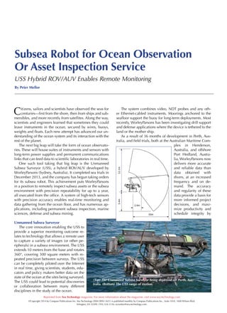
(Top) USS software showing way-
points for repetitive coral surveys
for marine construction monitor-
ing. (Right) The USS undertaking a
terrestrial inspection at almost full
extension.
(Top) The USS undertaking re-
mote conspicuous CCTV inspec-
tions. (Bottom) The topside buoy
for the USS (note the skid being
lowered into the buoy).
Peter Mellor is the manager of ports, marine terminals
and marine sciences within WorleyParsons’s Perth,
Australia, office and is a Ph.D. candidate. He has led
field teams and project delivery for more than 300
million cubic meters of dredging. He leads technol-
ogy development of diverless solutions at WorleyPar-
sons for a range of private and public sector clients.
Industry areas serviced include quarrying and min-
ing, petroleum and gas, water supply and treatment,
transport, defense and government authorities.