

Recommended
More Related Content
What's hot
What's hot (20)
Viewers also liked
Viewers also liked (15)
Similar to LiDAR
Similar to LiDAR (20)
Recently uploaded
Recently uploaded (20)
LiDAR
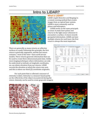
- 1. Josiah Parry April 12, 2016 Intro to LiDAR? What is LIDAR? LiDAR (Light Detection and Ranging) is a remote sensing method that creates images from an optical laser system. LiDAR is most commonly used on planes and helicopters. LiDAR works on the same principals as sonar. It emits laser pulses and returns to the light sensor whenever it encounters a surface. A return records geospatial information. LiDAR can have multiple returns for each laser; the ?irst return is always the most important. There are generally as many returns as re?lective surfaces in a path. Following this principle, the ?irst return is generally vegetation, and the last return contains—most of the time—bare-earth terrain models. These returns generate information that can be used to create three-dimensional point data. Unlike most imaging techniques where information can only be understood as latitude an longitude coordinates, we can obtain elevation from our returns. LiDAR records the elevation at which the return was sent, and this is where our third (Z) coordinate originates. For each point that is collected a measure of intensity is taken. Intensity is a measure based partly on the re?lectivity of the object encountered during the return. Intensity can be used to create grayscale imagery. Remote Sensing Application 1