1. Inventory of Tourists by Country of Origin
Republic Act 9593, better known as the Tourism Act of 2009 and embodied in the
DOT-JICA Project, Development of Tourism Statistics System for local government
units, there is a need to establish an efficient and effective way of getting tourist arrival
by country of origin.
Coming to Puerto Galera, tourist has many entry points. From Calapan City, by land,
and from Batangas City, by boat.
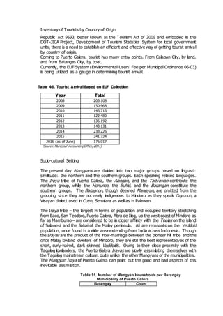
Currently, the EUF System (Environmental Users’ Fee per Municipal Ordinance 06-03)
is being utilized as a gauge in determining tourist arrival.
Table 46. Tourist Arrival Based on EUF Collection
Socio-cultural Setting
The present day Mangyans are divided into two major groups based on linguistic
similitude: the northern and the southern groups. Each speaking related languages.
The Iraya tribe of Puerto Galera, the Alangan, and the Tadyawan contribute the
northern group, while the Honunoo, the Buhid, and the Batangan constitute the
southern groups. The Batagnon, though deemed Mangyan, are omitted from the
grouping since they are not really indigenous to Mindoro as they speak Cayonon, a
Visayan dialect used in Cuyo, Semirara as well as in Palawan.
The Iraya tribe – the largest in terms of population and occupied territory stretching
from Baco, San Teodoro, Puerto Galera, Abra de Ilog, up the west coast of Mindoro as
far as Mamburao – are considered to be in closer affinity with the Toalas on the island
of Sulawesi and the Sakai of the Malay peninsula. All are remnants on the Veddoid
population, once found in a wide area extending from India across Indonesia. Though
the Irayas are the product of the inter-marriage between the pioneer hill tribe and the
once Malay lowland dwellers of Mindoro, they are still the best representatives of the
short, curly-haired, dark skinned Veddoids. Owing to their close proximity with the
Tagalog lowlanders, the Puerto Galera Irayas are slowly assimilating themselves with
the Tagalog mainstream culture, quite unlike the other Mangyans of the municipalities.
The Mangyan Iraya of Puerto Galera can point out the good and bad aspects of this
inevitable assimilation.
Table 51. Number of Mangyan Households per Barangay
Municipality of Puerto Galera
Barangay Count
Year Total
2008 205,108
2009 150,968
2010 145,715
2011 122,480
2012 136,192
2013 140,131
2014 233,226
2015 241,724
2016 (as of June) 176,017
(Source: Municipal Accounting Office, 2011)
2. Aninuan 285
Balatero 18
Dulangan 63
Sabang 48
Tabinay 318
Villaflor 841
Baclayan 492
Total 2065
Source: CBMS Survey 2008
As per CBMS survey in 2008, the total Mangyan population in the municipality is 2065,
of which 1092 are male and 973 are female. Villaflor inhabited with most number of
Mangyans with 841 while Balatero has the least number with only 18.
LUGO SERIES: Soils are moderately deep, well drained and under the fine
clayey family. Located at 2,650 meters N 65degrees E of Puerto Galera and
about 350 meters north of Barangay Sinandigan, 465 hectares in extent, more
or less.
1. Lugo Clay: 2.0 to 7.0% slopes. Mapped adjacent to the narrow beaches in
the northeastern portion of Puerto Galera, approximately 25 hectares in
extent.
2. Lugo Clay: 7.0 to 15% slopes. Mapped at the tip of Mindoro Island in hilly
portions towering the sea, 65 hectares in extent.
3. Lugo Clay: 15 to 25% slopes. 375 hectares in extent. Occurs in hilly to
mountainous or elevated lands. Located at the northeastern portion of the
town proper of Puerto Galera.
Soil
Mapping
Unit Name
Area
(Ha.)
Percentage
%
Recommended Land Use, Soil
Management Or Conservation Measures
Lugo clay
2.0 to 7.0%
slope
25 0.17
Suited to wide variety of crops. Measures to
prevent erosion are contour flowing, green
maturing, crop rotation with legumes as one of
the crops every 3-4 years, contour planting,
fertilization and the like.
Lugo clay
7.0 to
15.0% slope
slightly
65 0.54
Suitable to crops like corn, upland rice,
sorghum and others, provided contour
plowing, terracing, strip cropping, cover
cropping, crop rotation, fertilization and buffer
3. Month
Rainfal
l
No.
of
Rain
y
Days
Temperature °C Relative
Humidit
y
(%)
Wind
Amoun
t
(mm)
Mea
n
Minimu
m
Maximu
m
Dir Spd
(mps
)
JAN 93.0 16 28.9 22.2 25.5 84 NE 2
FEB 56.0 10 29.7 22.4 26.0 82 NE 2
MAR 70.4 9 30.8 23.1 27.0 80 E 2
APR 114.8 10 32.0 24.0 28.0 79 E 2
MAY 156.4 12 32.8 24.2 28.5 81 E 2
JUN 219.5 15 32.4 23.9 28.1 83 NE 2
JUL 241.8 17 31.9 23.6 27.7 84 N
W
2
AUG 189.6 15 31.8 23.6 27.7 84 N
W
2
SEP 218.9 16 31.8 23.6 27.7 85 NE 2
OCT 325.5 18 31.2 23.6 27.4 86 NE 2
NOV 244.5 19 30.4 23.4 26.9 86 NE 2
DEC 211.3 20 29.2 22.7 25.9 86 NE 2
strip cropping are employed. Best suited to
permanent crops like coffee, banana, mango,
coconut and other locally adopted fruit trees,
and for pasture purposes.
Lugo clay
15.0 to
25.0% slope
slightly
eroded
375 2.72
Suited to coconut, banana, coffee, cashew,
abaca, mango, rubber and other locally
adopted fruit trees. Cover crops, fertilization,
contour planting are also recommended to
minimize erosion. Can still be grown to raw
crops like corn, upland rice, sorghum and
others provided erosion control measures like
terracing, strip cropping and buffering are
employed.
4. TOTA
L
2,141.5 177 31.1 23.4 27.2 83 NE 2
Physical Soil Qualities
Relief Rolling to hilly
Water retention Moderate
Drainage Good
Permeability Rapid
Workability/tilth Hard to moderate
Stoniness None
Root depth Moderate (0.5m)
Erosion Severe
Flooding None
LANDSCAPE Alluvial
LANDFORM
PARENT
MATERIAL
SOIL SERIES
/TAXONOMIC
NAME
SOIL MAPPING
UNIT SYMBOL
SOIL MAPPING
DESCRIPTION