SlideShare a Scribd company logo
1 of 11
Drylands Development Program.
Nature of Dry Dev Interventions (Design
Thinking)
Collect Earth for Baseline Survey and
Monitoring and Evaluation.
(What is collect earth?)
O Land Use and Land Use Change
monitoring tool for drylands.
O Developed by FAO and the Google Earth.
O Interfaced on freely available satellite
imagery on google.
Grids Generated on Satellite Image.
Data Entry on Specially Designed Survey
Data Entry Process and Analysis on Code
Editor (NDVI), Sentinel 2 and Modis
Analysis on Landsat 5,7 and 8
Table Presentation
Tree Cover Classes
Map of Tree Covers Classification
Application of Collect Earth to
Dry Dev.
O Baselines, Monitoring and evaluation of
land use change (tree covers) and
performance.
O Socioeconomic impact monitoring and
policy governance.
O Study conducted at various resolutions
depending on the study area.(course,
medium and high resolutions).
O Proposal development on how this is
applicable to diverse project sites.
THANK YOU

More Related Content

What's hot

Aag abstract Climate_scope
Aag abstract Climate_scopeAag abstract Climate_scope
Aag abstract Climate_scope
Alfonso Crisci
 

What's hot (20)

Wf sblm2012 ilf
Wf sblm2012 ilfWf sblm2012 ilf
Wf sblm2012 ilf
 
ITEM 6. Global Soil Salinity Map: Review the Concept Paper and the Technical ...
ITEM 6. Global Soil Salinity Map: Review the Concept Paper and the Technical ...ITEM 6. Global Soil Salinity Map: Review the Concept Paper and the Technical ...
ITEM 6. Global Soil Salinity Map: Review the Concept Paper and the Technical ...
 
ITEM 7. Global SOC Sequestration Potential Map: Review of the Concept Paper a...
ITEM 7. Global SOC Sequestration Potential Map: Review of the Concept Paper a...ITEM 7. Global SOC Sequestration Potential Map: Review of the Concept Paper a...
ITEM 7. Global SOC Sequestration Potential Map: Review of the Concept Paper a...
 
Improving science (communication) through data visualization
Improving science (communication) through data visualizationImproving science (communication) through data visualization
Improving science (communication) through data visualization
 
Why spatially determining of SDGs matters for landscapes in the German Lusati...
Why spatially determining of SDGs matters for landscapes in the German Lusati...Why spatially determining of SDGs matters for landscapes in the German Lusati...
Why spatially determining of SDGs matters for landscapes in the German Lusati...
 
S Ramage GEO_IEOS Nov 2017
S Ramage GEO_IEOS Nov 2017S Ramage GEO_IEOS Nov 2017
S Ramage GEO_IEOS Nov 2017
 
Satellite Image Processing Projects Research Help
Satellite Image Processing Projects Research HelpSatellite Image Processing Projects Research Help
Satellite Image Processing Projects Research Help
 
Ramage GEO-CRADLE March 2018 Istanbul
Ramage GEO-CRADLE March 2018 IstanbulRamage GEO-CRADLE March 2018 Istanbul
Ramage GEO-CRADLE March 2018 Istanbul
 
Experience 3. SISLAC - Carolina Olivera Sanchez
Experience 3. SISLAC - Carolina Olivera SanchezExperience 3. SISLAC - Carolina Olivera Sanchez
Experience 3. SISLAC - Carolina Olivera Sanchez
 
Aag abstract Climate_scope
Aag abstract Climate_scopeAag abstract Climate_scope
Aag abstract Climate_scope
 
05 b ge graphsttp2020
05 b  ge graphsttp202005 b  ge graphsttp2020
05 b ge graphsttp2020
 
Land use analysis in GMS
Land use analysis in GMSLand use analysis in GMS
Land use analysis in GMS
 
Emerging mapping practices in and out of the classroom
Emerging mapping practices in and out of the classroomEmerging mapping practices in and out of the classroom
Emerging mapping practices in and out of the classroom
 
GEOtop Sisef presentation
GEOtop Sisef presentationGEOtop Sisef presentation
GEOtop Sisef presentation
 
S Ramage GEO_EFGS Nov 2017
S Ramage GEO_EFGS Nov 2017S Ramage GEO_EFGS Nov 2017
S Ramage GEO_EFGS Nov 2017
 
30. z. t. khan and dipankar bera
30. z. t. khan and dipankar bera30. z. t. khan and dipankar bera
30. z. t. khan and dipankar bera
 
Improving scientific graphics of climate (change) data
Improving scientific graphics of climate (change) dataImproving scientific graphics of climate (change) data
Improving scientific graphics of climate (change) data
 
Change detection using remote sensing and GIS
Change detection using remote sensing and GISChange detection using remote sensing and GIS
Change detection using remote sensing and GIS
 
Esip 2011 jdmoore
Esip 2011 jdmooreEsip 2011 jdmoore
Esip 2011 jdmoore
 
S Ramage GEO UN-GGIM HLF Mexico Nov 2017
S Ramage GEO UN-GGIM HLF Mexico Nov 2017S Ramage GEO UN-GGIM HLF Mexico Nov 2017
S Ramage GEO UN-GGIM HLF Mexico Nov 2017
 

Viewers also liked (12)

Chp1.1 - Unit 1 (First Lecture)
Chp1.1 - Unit 1 (First Lecture)Chp1.1 - Unit 1 (First Lecture)
Chp1.1 - Unit 1 (First Lecture)
 
Sociedad del conocimiento
Sociedad del conocimientoSociedad del conocimiento
Sociedad del conocimiento
 
resume
resumeresume
resume
 
Romsb.presentacion.slideshare
Romsb.presentacion.slideshareRomsb.presentacion.slideshare
Romsb.presentacion.slideshare
 
Edward Russell Thule
Edward Russell ThuleEdward Russell Thule
Edward Russell Thule
 
Cazadores de microbios
Cazadores de microbiosCazadores de microbios
Cazadores de microbios
 
Sampling
SamplingSampling
Sampling
 
Resume
ResumeResume
Resume
 
Educ.fisica tic II Barria Barbara
Educ.fisica tic II Barria BarbaraEduc.fisica tic II Barria Barbara
Educ.fisica tic II Barria Barbara
 
Chp1.2
Chp1.2Chp1.2
Chp1.2
 
Covisint and Starbucks IdaaS Partnership Infographic
Covisint and Starbucks IdaaS Partnership InfographicCovisint and Starbucks IdaaS Partnership Infographic
Covisint and Starbucks IdaaS Partnership Infographic
 
Presentacion con diapositiva power point, barbara ramirez
Presentacion con diapositiva power point, barbara ramirezPresentacion con diapositiva power point, barbara ramirez
Presentacion con diapositiva power point, barbara ramirez
 

Similar to Dry_Dev_Presentation

Module 10 - Section 4: ICTs for understanding and monitoring the environment ...
Module 10 - Section 4: ICTs for understanding and monitoring the environment ...Module 10 - Section 4: ICTs for understanding and monitoring the environment ...
Module 10 - Section 4: ICTs for understanding and monitoring the environment ...
Richard Labelle
 
Bio inspired computational techniques applied to the analysis and visualizati...
Bio inspired computational techniques applied to the analysis and visualizati...Bio inspired computational techniques applied to the analysis and visualizati...
Bio inspired computational techniques applied to the analysis and visualizati...
askroll
 
Mangrove Vegetation Mapping Using Sentinel-2A Imagery Based on Google Earth E...
Mangrove Vegetation Mapping Using Sentinel-2A Imagery Based on Google Earth E...Mangrove Vegetation Mapping Using Sentinel-2A Imagery Based on Google Earth E...
Mangrove Vegetation Mapping Using Sentinel-2A Imagery Based on Google Earth E...
Luhur Moekti Prayogo
 

Similar to Dry_Dev_Presentation (20)

Application Of GIS In Environmental Engineering
Application Of GIS In Environmental EngineeringApplication Of GIS In Environmental Engineering
Application Of GIS In Environmental Engineering
 
Fyp presentation
Fyp presentationFyp presentation
Fyp presentation
 
Environment Impact Assessment Using Remote Sensing
Environment Impact Assessment Using Remote SensingEnvironment Impact Assessment Using Remote Sensing
Environment Impact Assessment Using Remote Sensing
 
Module 10 - Section 4: ICTs for understanding and monitoring the environment ...
Module 10 - Section 4: ICTs for understanding and monitoring the environment ...Module 10 - Section 4: ICTs for understanding and monitoring the environment ...
Module 10 - Section 4: ICTs for understanding and monitoring the environment ...
 
SOIL MAPPING USING GIS
SOIL MAPPING USING GISSOIL MAPPING USING GIS
SOIL MAPPING USING GIS
 
3. Technical introduction to the Digital Soil Mapping
3. Technical introduction to the Digital Soil Mapping3. Technical introduction to the Digital Soil Mapping
3. Technical introduction to the Digital Soil Mapping
 
Introduction to DSM
Introduction to DSMIntroduction to DSM
Introduction to DSM
 
5. Introduction to Digital Soil Mapping
5. Introduction to Digital Soil Mapping5. Introduction to Digital Soil Mapping
5. Introduction to Digital Soil Mapping
 
ASSESSMENT OF URBAN DYNAMICS IN LAND USE AND DEMOGRPAHY USING GIS TECHNIQUES
ASSESSMENT OF URBAN DYNAMICS IN LAND USE AND DEMOGRPAHY USING GIS TECHNIQUESASSESSMENT OF URBAN DYNAMICS IN LAND USE AND DEMOGRPAHY USING GIS TECHNIQUES
ASSESSMENT OF URBAN DYNAMICS IN LAND USE AND DEMOGRPAHY USING GIS TECHNIQUES
 
Ramage Keynote ISPRS Geospatial Week 2017
Ramage Keynote ISPRS Geospatial Week 2017Ramage Keynote ISPRS Geospatial Week 2017
Ramage Keynote ISPRS Geospatial Week 2017
 
Global Soil Data Task, part of Earth Data Sets - Vincent van Engelen
Global Soil Data Task, part of Earth Data Sets - Vincent van EngelenGlobal Soil Data Task, part of Earth Data Sets - Vincent van Engelen
Global Soil Data Task, part of Earth Data Sets - Vincent van Engelen
 
application of gis
application of gisapplication of gis
application of gis
 
Lesson1 esa summer_school_brovelli
Lesson1 esa summer_school_brovelliLesson1 esa summer_school_brovelli
Lesson1 esa summer_school_brovelli
 
Bio inspired computational techniques applied to the analysis and visualizati...
Bio inspired computational techniques applied to the analysis and visualizati...Bio inspired computational techniques applied to the analysis and visualizati...
Bio inspired computational techniques applied to the analysis and visualizati...
 
The Global Land Programme
The Global Land ProgrammeThe Global Land Programme
The Global Land Programme
 
Ramage GEO World Urban Forum KL 2018
Ramage GEO World Urban Forum KL 2018Ramage GEO World Urban Forum KL 2018
Ramage GEO World Urban Forum KL 2018
 
Mangrove Vegetation Mapping Using Sentinel-2A Imagery Based on Google Earth E...
Mangrove Vegetation Mapping Using Sentinel-2A Imagery Based on Google Earth E...Mangrove Vegetation Mapping Using Sentinel-2A Imagery Based on Google Earth E...
Mangrove Vegetation Mapping Using Sentinel-2A Imagery Based on Google Earth E...
 
Gis powerpoint
Gis powerpointGis powerpoint
Gis powerpoint
 
Final report-2.pdf
Final report-2.pdfFinal report-2.pdf
Final report-2.pdf
 
Building capacities for digital soil organic carbon mapping
Building capacities for digital soil organic carbon mappingBuilding capacities for digital soil organic carbon mapping
Building capacities for digital soil organic carbon mapping
 

Dry_Dev_Presentation

Editor's Notes

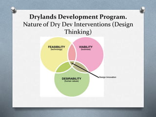
  1. Design and development of new products (hardware and services) and processes (technical and organizational), with particular focus on methods, tools and strategies for the early phases of the innovation process. Desirability Will this solution fill a need? Will it fit into people’s lives? Will they actually want it? Feasibility Is the technology needed to power the design solution available or within reach? How long will this take? Can the organization actually make it happen? Viability Will the design solution align with the project goals? Does this solution honor the donor’s budget? What will the return on the investment look like?
  2. Free open source software. No special GIS background required. Easily Scaled up.