James Assinder | Transport Accessibility Review
•
0 likes•268 views

Transport Accessibility Review

Recommended
Recommended
More Related Content
What's hot
What's hot (20)
Viewers also liked
Viewers also liked (9)
Similar to James Assinder | Transport Accessibility Review
Similar to James Assinder | Transport Accessibility Review (20)
Recently uploaded
Recently uploaded (20)
James Assinder | Transport Accessibility Review
- 2. 1. Introduction DTL Development are proposing to build 150 residential dwellings on land accessed via Lower Drayton Lane, Cosham near Portsmouth (location as shown in Figure 1). This report has been prepared to review the accessibility of the proposed development site by sustainable modes of transport including walking and cycling and examines the access by these modes to local facilities, amenities and public transport interchanges. The Department for Transport's Guidance on Transport Assessment outlines the need to locate good access points and links for pedestrians and cyclists to the local area and the wider transport network which will also encourage the use of public transport. Figure 1 - Site Location Plan
- 3. 2. Walking The development site will provide a number of access points for pedestrians to connect to existing road networks and public footpaths. This includes access to the east of the site via Lower Drayton Lane with the potential to propose improvements by opening up points to the north of the site to link to the footpath leading to Drayton Park and the local play area. The Department for Communities and Local Government's National Planning Policy Framework highlights that for larger scale residential developments 'key facilities such as primary schools and local shops should be located within walking distance of most properties.' The local area of Drayton provides a range of facilities and amenities within a reasonable walking distance of 1.6km, which is equivalent to a 20 minute journey time. These include: ● Drayton local centre which includes shops and restaurants ● Court Lane Infant and Junior School ● Springfield College ● Drayton Park and play area ● Health centre and pharmacy ● Community centre ● Local shops including Co-op ● Sainsbury's ● Business units
- 4. Site location 1.6km walking catchment Bus stops local to site Park and play area Health centre / pharmacy Community centre KEY School College Local shops Sainsbury’s Railway station Figure 2 - Walking Accessibility
- 5. Figure 2 illustrates the walking catchment from the main entrance of the proposed development site. As can be seen from the plan the majority of the local amenities and public transport interchanges are easily accessible on foot. Although Drayton is the closest centre to the development site, additional facilities not present locally include a library and post office in the centre of Cosham. However a walking distance of 1.9km to the nearest library and post office will not be acceptable to some. Pedestrian links to the south are also limited due to the railway line with only one current route available within a 1.6km walking distance via a pedestrian footbridge which might not be easily accessible to some residents. There are a number of local bus stops with the closest within a walking distance of 400m, which is equivalent to a 5 minute walk, on Grove Road close to the junction with Lower Drayton Lane. There is good access to the bus stop which can be reached comfortably on foot via the footways on Lower Drayton Lane, providing public transport links to other amenities not easily accessible on foot. The footways on Lower Drayton Lane leading to the proposed development site appear to be in good condition and are reasonably lit on alternating sides of the road. The footway is of a width of 2 metres or more along the west side of the road which allows for sufficient space for pedestrians, wheelchair users and pushchairs to pass especially where cars have been observed parked partly on the footway. Similarly Old Manor Way, Grove Road and the adjacent roads have good quality and well lit footways on both sides thereby giving pedestrians a safe environment to access local amenities in the north.
- 6. The footways on Grove Road run along the full length of the carriageway linking the proposed development site with the college, Sainsbury's and local business units. There are pedestrian crossing points along the busy Eastern Road dual-carriageway with the closest at the junction with Grove Road. The crossing point is situated at a set of traffic lights with an island between the carriageways. However it is not a controlled crossing point which will severely reduce the safety to pedestrians accessing the supermarket and make crossing the road more difficult especially at peak times. There is a 20mph speed limit zone in place along the south perimeter of Springfield College on Grove Road which will allow for safer crossing for residents of the proposed development site. This zone could benefit additionally if improvements were proposed such as traffic calming measures and raised speed cushions to further slow traffic and improve the overall pedestrian environment for the residents. The table below shows the approximate walking times to each of the local amenities by plotting routes from the main entrance to the proposed development site. As can be seen from the table there is a good number of local amenities within a reasonable walking distance. Destination Approx. walking journey time (minutes) Drayton local centre including shops and restaurants 10 Court Lane Infant and Junior School 12 Springfield College 3 Health centre and pharmacy 14 Community centre 12 Local shops including Co-op 8 Sainsbury's / Business units 10
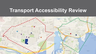
- 7. 3. Cycling The proposed development site will provide connections to a number of local and national cycle routes within the surrounding area and offer access to facilities in the city, including leisure, health, education and employment opportunities. The Department for Transport's Local Transport Note 2/08: Cycle Infrastructure Design highlights typical cycle trip distances and notes that 'many utility cycle journeys are under 3 miles, although, for commuter journeys, a trip distance of over 5 miles is not uncommon.' This places a significant proportion of the city of Portsmouth within a reasonable cycling distance connecting residents to the city centre, hospitals, harbour and the university.
- 8. Site location 5km cycle catchment Railway station KEY Figure 3 - Cycle Accessibility
- 9. Figure 3 illustrates the cycle catchment of the surrounding area. As can be seen from the plan a large area of the city will be within a reasonable cycling distance of 5km of the development, which is equivalent to a 25 minute cycle. The site is ideally placed to benefit from the designated National Cycle Route 22 directly north of the site which runs along Old Manor Way and Grove Road. This part of the route is on road and has no designated lanes for bicycles, but is classed as cycle-friendly due to the 20mph speed restriction in place along much of the road in comparison to other parts of the road network. Directly south of the proposed development site runs the West Coastway railway line from Brighton to Southampton. This provides an excellent opportunity for cyclists and pedestrians to travel only 1.6km to catch the train from Cosham station into the centre of Portsmouth where there are many bicycle parking facilities available. From the area of Cosham, the cycle route continues south along dedicated off road cyclepaths which run adjacent to Ports Creek waterway for much of the route. This connects cyclists to the city centre and provides opportunities for leisure. From Grove Road, the cycle route links to National Cycle Route 222 which runs north to south on dedicated off road cyclepaths connecting cyclists to the many business parks off Eastern Road. These routes will provide residents of the proposed development site the opportunity to cycle safely and will give a real alternative to the car for journeys to places of work.