
Recommended
Recommended
More Related Content
Similar to Zere- El Tarachi, Veracruz, ARR Short.pdf
Similar to Zere- El Tarachi, Veracruz, ARR Short.pdf (20)
Recently uploaded
Recently uploaded (20)
Zere- El Tarachi, Veracruz, ARR Short.pdf
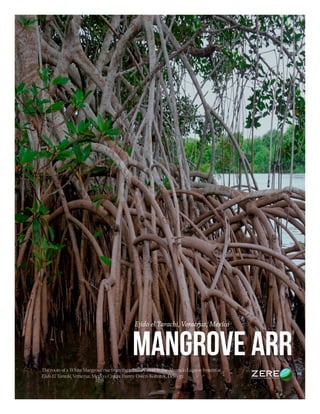
- 1. MANGROVE ARR Ejido el Tarachi, Veracruz, Mexico The roots of a White Mangrove rise from the tributary river in the Alvarado Lagoon System at Ejido El Tarachi, Veracruz, Mexico. Credit: Danny Owen-Kohutek, Deko 37.
- 2. Contents 05 2018 Business Proposal THE OPPORTUNITY 06 Numbers of our company 08 Project Team Leader 10 Article 12 Case Study 01 14 Undertanding those we serve 16 Data analysis 18 Why you should choose us 19 Services & Rates 20 Projects 22 3 2 Ejido el Tarachi, Veracruz, Mexico Project Proposal Contents MANGROVE ARR Ecological restoration of a mangrove swamp in the Ejido El Tarachi municipality of Acula, Veracruz; through hydrological rehabilitation, manipulation of micro-topography and control of invasive species. Number of hectares to be restored: 58 hectares Amount requested: $ 3, 133.880.00 MX ( $156,694 USD approx) Property Name: Ejido El Tarachi, Acula, Veracruz Project Lead: Pablo Granados Granados Email: granadospablo@hotmail. is Private phone: 228 110 2545 Address: Orilla del Rio Acula S/N, Loc. El Tarachi C.P. 95250, Alvarado, Ver. Senior Technical advisor: Juan Teofanis López Sayago National Forest Registry: VER/UI/2/40/15 Notice & Disclaimer: Zere, zere.io and the work and by-product described in this presentation is property of Plataforma Zere S.A.P.I. de C.V. and its partners. All images are © 2022-2023 Zere, Pablo, Granados, and Eduardo Celis. Ex- cept for the image on page 9, which is © Wirestock and used under license. No portion of this document may be reproduced, re-transmitted, or shared with third parties without their specific written consent . This document is provided as a sample of work by Zere LLC and its associates. It is not an offering circular and has not been released in collaboration with, or approved by, any governmental or regulatory authority. This document has been prepared by for internal purposes, and to be shared with a number of prospective partners. Each person receiving this document expressly acknowledges having read and acknowledged the content of this Disclaimer. This document was last edited May 18th, 2023. Special thanks to Danny Owen-Kohutec and Deko 37. Illustration Index....................................................................................................................................................................................... 5 Table Index..................................................................................................................................................................................................9 Project Justification................................................................................................................................................................................10 Project Summary....................................................................................................................................................................................14 Project Location......................................................................................................................................................................................16 Diagnosis of Biological Vulnerability of the Proposed Species..............................................................................................16 Ecology and Environmental Requirements............................................................................................................................................................18 Project Site Diagnosis............................................................................................................................................................................24 Description of the ecosystem..........................................................................................................................................................24 Reference Ecosystem............................................................................................................................................................................34 Description of Works..........................................................................................................................................................................40 Technical proposal.......................................................................................................................................................................... 40 Protection of the area.......................................................................................................................................................................42 Works for the restoration of water flows......................................................................................................................................46 Reforestationn...................................................................................................................................................................................47 Maintenance in restored areas......................................................................................................................................................50 Technical advisory proposal..........................................................................................................................................................52 Calendar of activities......................................................................................................................................................................56 Economic Proposal............................................................................................................................................................................... 58
- 3. 5 4 El Tarachi Project Proposal www.zere.io Figure 1. Macro geographical location of the areas to be restored in the Ejido El Tarachi of the municipality of Acula in the State of Veracruz..............................................................................................................................8 Figure 2. Rhizophora mangle (red mangrove), characteristic for having arched stilt roots........................................ 9 Figure 3. Avicennia germinans (black mangrove), this species of mangrove is characterized by its roots (pneumatophores) that emerge from the ground, an adaptation that allows them to breathe even in floodable conditions.................................................................................................................................................................................................. 10 Figure 4. Laguncularia racemosa (white mangrove), the specimens of this species are usually straighter shafts compared to the other species, and the color of its bark is white hence its name........................................................... 11 Figure 5. Map showing mangrove changes from 1981 to 2015 in the site with biological relevance and ecologi- cal rehabilitation needs in the Alvarado Lagoon System, Veracruz (SLAV) (CONABIO, 2016)...................................................................................................................................................................................14 Figure 6. Image of the area to be restored, only some mangrove relicts dominated by the invasive Thypha domingensis and Eleocharis cellulosa are observed...................................................................................................................15 Figure 7. Typical ombrothermal diagram of the station 00030201 Alvarado, Ver..........................................................16 Figura 8. Thornthwaite Climate graph 00030201 Alvarado (DGE)....................................................................................18 Figure 9. Soil core extracted in the area to be restored. The characteristic gray of Gleysol is observed. ........................................................................................................................................................................................................................21 Figure 10. Pablo Granados wades through a degraded mangrove field in El Tarachi that has been invaded by anea (Typha domingensis) ................................................................................................................................................................. 23 Figure 11. Mangrove area affected by forest fire, remains of mangrove trees burned and deposited on the sur- face water and soil of the wetland are now observed. You can also see how the anea is occupying the degraded site.................................................................................................................................................................................................................24 Figure 12. Large Sampling Unit Scheme and its Division into Medium Sampling Units.............................................28 Figure 13. Diagram of Small Sampling Units and Example of Random Placement within the Large Sampling Unit .............................................................................................................................................................................................................28 Figure 14. Schematic of Micro Sampling Units and mock random placement within the Large Sampling Unit...........................................................................................................................................................................................29 Figure 15. Number of individuals per species ha -¹, in the assessment unit of site 1, of the reference site.............30 IlLustrations
- 4. 9 8 El Tarachi Project Proposal www.zere.io TABLES Table 1. Unit costs and total quantities of work required......................................................................................................... 6 Table 2. Ideal calendar for the execution of the three strategies of restoration proposed, considering the cli- matic conditions of the municipality of Alvarado, Veracruz....................................................................................................19 Table 3. Chemical parameters determined in soil samples within the proposed restoration area...........................22 Table 4. Current condition of the proposed site for restoration...........................................................................................25 Tabla 5. Condition of the vegetation that keeps the degraded area occupied.................................................................26 Table 6. General information about the degradation of the site to be restored..............................................................26 Table 7. Dasometric data of the assessment unit at the reference site. Evaluation Unit no. 1, Latitude 18°42’36.20”N and Longitude 95°50’48.50”W............................................................................................................30 Table 8. Dasometric data of the assessment unit at the reference site. Unit d evaluation no.2, Latitude 18°42’23.30”N and Longitude 95°50’54.10”W.............................................................................................................30 Table 9. Data from the evaluation unit at the reference site. Evaluation Unit no.3, Latitude 18°42’11.35”N and Longitude 95°50’46.55”W...................................................................................................................................................31 Table 10. Inventory datafor diversity at species level, at the reference site....................................................................... 32 Table 11. Calculation of work and costs for protection activities.........................................................................................38 Table 12. Calculation of work and costs for water flow restoration activities..................................................................40 Table 13. Estimation of the percentage occupied by mangrove species in the restoration area, based on the information obtained at the reference site....................................................................................................................................44 Table 14. Calculation of the number of plants to be reforested by species.......................................................................44 Table 15. Calculation of work and costs of reforestation activities......................................................................................47 Table 16. Calculation of the work and costs of plant purchase activities..........................................................................49 Table 17. Indicators of success of maintenance actions............................................................................................................52
- 5. “Teamwork is the ability to work together toward a common vision. The ability to direct individual accomplishments toward organizational objectives. It is the fuel that allows common people to attain uncommon results.” 11 10 El Tarachi Project Proposal www.zere.io PROJECT JUSTIFICATION In Veracruz, the modification of hydrology due to deviations from river channels for agricultural purposes, the replace- ment of mangrove areas by aquaculture or tourist infrastructure works, the lack of management plans for these types of vegetation and the limited planning and management of productive activities, ignorance or difficulty in determining the ecological and economic value of goods, attributes and services provided by these environments, the expansion of live- stock lands and clandestine logging have contributed considerably to the disappearance of the mangrove area (Moreno et al., 2002). In the Alvarado Lagoon System, forest fires that spread and affect mangroves during the dry season between the months of March to June, are the main cause of surface loss of this type of vegetation, many of these accidents are caused by bird hunters and turtles, the first dare to promote the creation of clearings in the mangrove (elimination of mangroves in areas of up to half a hectare at the interior of extensive forests) to promote the arrival of birds such as the mallard duck and diverse singing birds (canates), and the second to motivate the turtles to leave their shelters and be able to catch them easily. The fires are carried out without any control measures, so in many cases the fire ends up consuming several hectares of mangrove. The forest fires that occur in these forest areas are usually underground or superficial, the com- bustible material that burns is the large amount of leaf litter and organic matter that has accumulated on the surface of the soil and in turn the roots (pneumatophores) and the base of the shafts of mangrove trees, The speed of the fire is very slow because they advance as if they were a wick or pabilo. However, it is recognized that one of the main economic activities in the state of Veracruz and within the Alvarado La- goon System, is the fight of cattle in an extensive way, a situation that also motivates the owners of properties to elimi- nate large areas of mangrove to proceed to establish forage pastures that will later be the food of the heads of cattle. To eliminate mangrove trees on these lands, the owners also resort to the use of fire. However, the situation is unknown that mangrove forests over the years accumulate organic matter in the surface horizon of the soil and once burned these sites suffer the phenomenon called soil subsidence, becoming low sites in which livestock can not walk because it is muddy and floodable and finally, These areas end up being abandoned to Withaltered microtopography and hydroperiod, invasive plant species such as Typha dominguensis that find their own conditions to establish themselves and colonize areas that once maintained mangrove vegetation, hindering the natural regeneration of mangrove species. While it is true that fire is the main cause of loss of mangroves in the Alvarado Lagoon System, these encourage the deg- radation not only of vegetation but also the hydroperiod is modified, because the trunks and branches of the trees when they die fall on the body of the channels, generate a plugging that accumulates silt until the arteries of the mangrove dis- appear and dry the land. Indeed, the term ecological restoration encompasses all those activities or actions to improve the current conditions of the degraded site; The term also refers to returning an ecosystem to its preconditions and includes natural restoration or recovery, following the basic principles of secondary succession. However, the methodology of ecological restoration in the forest field has become widespread, which promotes the reforestation of mangroves as the most effective recovery mechanism, being necessary the basic knowledge of the hy- droperiod of the region, the tidal regime and the micro topography (Flores-Verdugo et al., 2006; Benítez-Pardo, 2007). Therefore, to achieve the ecological restoration of the mangrove it is necessary to restore the hydroperiod. The resto- ration actions that we have successfully implemented in the Alvarado Lagoon System to restore the mangrove area are the following: 1. Remove and limit extensive livestock on the areas to be restored. This with the placement of protective fencing (with barbed wire and wooden posts). 2. Control invasive plant species by splashing. 3. Rehabilitation of the hydroperiod through cleaning, desazolve and construction of canals. 4. Manipulation of microtopography that consists of building raised cores or chinampas of 1 m2 throughout the de- graded surface, on which propagules are planted or mangrove trees are planted. 5. The aforementioned restoration activities must necessarily be complemented with the opening of firebreaks and controlled burns and even maintenance, that is, plant replacement and weed plating for three or four years after re- forestation. If the restoration actions indicated above are not implemented within the degraded areas, they tend to suffer loss of bio- diversity of flora and fauna, alteration of the hydroperiod, reduction of the mangrove area, decrease in fish production on which many families depend in the municipalities of Alvarado, Ignacio de la Llave, Acula and Tlacotalpan. The pos- sibility of incidence of forest fires increases due to the large amount of combustible material produced by the invasive The Ejido is part of the Alvarado Lagoon, system, one of the most important mangrove regions in the continent
- 6. 17 16 El Tarachi Project Proposal www.zere.io PROJECT LOCATION The property proposed for restoration is an area of 58 hectares and is composed of 5 polygons of the Ejido El Tarachi of the municipality of Acula, Veracruz. The geographical location of the polygonal of the proposed property is shown on the following map: Figure 1. Macro geographical location of the areas to be restored in the Ejido El Tarachi of the municipality of Acula in the State of Veracruz. Diagnosis of biological vulnerability of the proposed species. Overview of the conservation status of the species and their habitat. The mangrove species reported with natural distribution in the Alvarado Lagoon System are Avicennia germinans (black mangrove), Laguncularia racemosa (white mangrove ) and Rhizophora mangle (red mangrove). The descrip- tion of the species as described by (Moreno-Casasola & Infante Mata, 2016), is done below: Description of the proposed species. Rhizophora mangle (red mangrove): It is a very characteristic tree for its roots in the form of stilts. It reaches heights of 15 meters or more, although in some areas that coincide with the mouth of the rivers, it reaches 30 meters. They are ev- ergreen trees or shrubs, which never run out of leaves (evergreen), with straight trunks. The trunk is thin, with a fissured outer bark, light gray and the color tone under the bark of the tree, ranging from pink to quite red. From its stems origi- nate aerial roots shaped like stilts (called fulcreas), which can reach five meters above the base and from which another root frequently emerges, and from the latter in turn another of smaller size, chaining. This network of roots allows them to function as retention nets for leaves, trunks, dead animals, etc., and as a protection zone for other mangrove inhabi- tants such as fish, shrimp, thus forming a vegetable island. These roots allow it to grow taking up space not only with its crown, but also with its roots and help hold the plant in very muddy soil. On the roots you can see many small pores that are called lenticels and help the plant breathe. Also numerous species of animals adhere to the roots (oysters, balanos, etc.) or climb them in search of food like crabs. The leaves are large (6 to 10 cm long by 2 to 5 cm wide), bright green on the upper side and yellowish green on the underside, placed on opposite sides of the branch, facing each other. They have an ellipse shape and smooth edges, ending in a point and are somewhat hard, with a leathery and fleshy sensation. On the underside of the leaf you can see small spots of deep green. Figure 2. Rhizophora mangle (red mangrove), characteristic for having arched stilt roots. The flowers sprout two to four, together, on a greenish pitchfork-shaped stem. They have four narrow sepals about a centimeter long yellow-green, with four narrow white petals about two centimeters long, which eventually become light brown and woolly inside. The inside of the flower in the central part is yellow, and they are visited by bees and other insects. They bloom and bear fruit throughout the year, although mainly in the spring and in the rainy season between June and October. The fruit is ovoid dark brown with a single seed. The seed germinates in the plant, inside the fruit, when it is still attached to the plant, and right there the embryonic stem (hypocotyl) begins to grow. It is common to see these seedlings hanging from the tree like pencils. Then they detach, once the hypocotyl reaches about 20-40 cm long. They are swept away and thus dispersed by the water mainly. Avicennia germinans (black mangrove, prieto mangrove): It is a tree between 10 and 30 meters tall (when it lives in good conditions it reaches up to 40 meters) and a trunk of 10 to 50 cm in diameter. The crown is shaped like an umbrella and the foliage is scattered. The color is more ashy than that of the red mangrove, so it is usually easy to distinguish them in the landscape. The trunk is straight and cylindrical, sometimes irregular with ascending branches. The outer crust is black, with fissures forming small rectangular plates. This species regrows well when cut, although layering techniques
- 7. 47 46 www.zere.io El Tarachi Project Proposal Reforestation The second restoration strategy involves manipulating the microtopography, raising the current height of the soil to recover the original level of the site that was lost due to soil subsidence, when the organic matter that was accumulated in the upper horizon of the land was incinerated. For this purpose , they will build lifting cores or chinampas described below. Core elevation (chinampas) This activity consists of making sediment cores (chinampas) of 1 square meter, the height of the mound will be a func- tion of the average level of the high tide in each place. The objective of raising the land is to have a firm site where the saplings or propagules of the different mangrove species can be planted and prevent the plants that are established there from dying by drowning. The construction of 400 chinampas per hectare with spacing between chinampas of 5 meters from the center of each chinampa is proposed; in 39 hectares proposed for restoration, a total of 15,600 nuclei will be built. Figure 27 shows the areas where the chinampas will be built. The first recorded works, which consider elevating microtopography as a viable and successful alternative to restore mangroves, were reported in 2009 in the Ejido Francisco Villa, Nayarit whose publication appears in the “Community Manual of Mangrove Restoration” (Figure 28). Other works that successfully report the implementation of chinampas are in the Alvarado Lagoon System in the state Figure 26. Chinampas built for the reforestation of mangrove plants in Ejido Francisco Villa in December 2009, Nayarit (CONAFOR-UNITED KINGDOM, s.f.). Figure 25. Map showing the areas of the set of properties that will be intervened with the construction of chinampas. Figure 27. Reforestation of mangrove plants on chinampas built from sediment in the Ejido Costa de San Juan in the municipality of Alvarado, Veracruz.
- 8. 51 50 www.zere.io El Tarachi Project Proposal The plants will be established on the chinampas of 1 m2 previously built. Considering that the soil remains moist and soft after having been built, the holes appropriate to the size of the root system or wide and deep enough to allow the roots to be well extended and submerged on the raised core, then the sediment should be tamped gently to avoid spaces with air in the root zone. The reforestation of the 39 hectares is foreseen, with a density of 1,200 plants / ha, in total 46,800 mangrove saplings will be planted. Planting period According to the typical ombrothermal graph for the municipality of Alvarado (Figure ) in the state of Veracruz, the ide- al conditions for reforestation in the proposed site are given between the months of July to October when the ombroth- ermal conditions are surplus, that is, in this period the precipitation is greater than 100 mm per month, However, during the months of November and December it is still possible to continue with the planting work. The recommendation is made because the conditions are humid to very humid, the plants tend to be stress-free when the soil is kept perma- nently moist and specifically for the case of mangrove species to be established. Plant transport The plant purchased in the same UMA Ejidal of El Tarachi will be delivered by the person in charge of the UMA at the restoration site, where spaces of 8 m 2 will be conditioned whose condition suggests shade and permanent water sheet of at least 20 cm to submerge the root. The transport of the same is obligatorily in boats and canoes, the plant must be moved in the morning or in the afternoon when the intensity of the sun is lower to protect the plant from drying (Figure 32). Figure 29. Distribution of mangrove plant to bare root towards the reforestation areas with the support of canoes, this is placed to the surplus and the root is submerged in the water. Table 15. Calculation of work and costs of reforestation activities. It is suggested that the plants once extracted from the UMA, do not remain more than a week without being planted in the final site, this ensures the desired survival. Manual weeding with machete prior to the construction of chinampas and reforestation. As noted above, the degraded site that is now intended to be restored, remains colonized by invasive species which it is necessary to combat through the chapeo to allow the construction of chinampas and the planting of mangrove trees on the chinampas. In addition, the risk of fire damage to the site is reduced by eliminating the combustible material generat- ed by invasive plants. The targets and budget envisaged for reforestation activities are summarized in the following table: The cost of the elevated nucleas or chinampas is the only one that is not within the list of reference costs for the works and practices to be considered in the 2021 environmental compensation projects, however, the cost of $ 60.00 pesos is justified by equating the cost for 1 m3 (1m x 1 m x 1m) of excavation of channels that is equivalent to $ 200 pesos. The average dimensions of a chinampa are 1 m wide x 1 meter long x 0.3 meters high, that is, 0.3 m 3 of sediment are those that are required to excavate to form a chinampa, this sediment is deposited on a base previously built using plant mate- rial (remains of anea) that is placed as a base to give firmness to this work. Therefore, a chinampa corresponds to 30% of the excavation of 1 m 3 of channel, if mathematically we determine how much it represents monetarily 30% of the 200 pesos of m3 of excavation of channels, this is equivalent to $ 60 pesos which are raised in the cost table indicated above as cost per chinampa.
- 9. 53 52 www.zere.io El Tarachi Project Proposal Purchase of short-cycle plant (usually species of the tropical and arid and semi-arid ecosystem). The success in the restoration is to have a quality plant. It requires plants with lignified stem a diameter greater than 6 mm and size between 70 to 90 centimeters in height. The successful experiences where survival greater than 95% has been achieved refers to the use of plant acquired in Wildlife Conservation Management Units (UMA) established in the same area, and corresponds to bare root plant (Figure 33). Figure 30. Bare root mangrove plant acquired in UMA with a legally authorized use rate by the DGVS of SEMARNAT, which have been successfully established in the reforestation works, achieving survival of more than 95%. Nursery that will supply the plant The mangrove plants with the required quality and that has shown the highest percentage of survival once established in the reforested areas is that coming from the UMA’s with exploitation rates legally authorized by SEMARNAT, in this case it is proposed the purchase of plant in the UMA El Tarachi located in the Congregation El Tarachi of the municipal- ity of Alvarado, Veracruz with registration key (UMA registration is attached and authorization of rate of use of plants to bare root). The plants are produced under the bare root system, their production begins in the months of October and ends in March when it is still possible to collect propagules, it is planted in different months to have plant available for most of the year. This system has been implemented with good results because it is possible to produce plant with the desired characteristics. Maintenance in restored areas One of the main problems that limit the regeneration or development of mangrove species within degraded areas, is that the invasive Thypha domingensis (anea) colonizes the land because it is a species of herbaceous condition and very fast growing forming dense and monospecific populations, competing for light and space, also produces a large amount of combustible material by the constant renewal of its leaves, and represents a latent risk of forest fire that can affect the mangrove trees planted on the site. The fight against this invader is an obligatory activity during the restoration process, with the manual chapeo with machete the population is reduced and gaps of approximately 2 meters wide are opened to allow the construction of chinampas and the establishment of mangrove plants. Once the gaps are opened, maintenance is required at least every 3 or 4 months during the proposed 4 years of maintenance. If maintenance is not done in time, the anea will colonize the gaps again and practically it will be necessary to open them again, and will demand greater economic investment. The Typha during the opening and maintenance of the gaps to allow reforestation, should always be cut under water to prevent it from regrowing and lasting much longer the clean gaps (Figure 34). Figure 31. Image left side shows example of the way in which the Typha will be cut below the high tide, in the image on the right side you can see a gap on which the anea was plated under the water and its leaves scattered over the gap to limit the entry of light to the cut plant and prevent even more that this regrowth again. Table 16. Calculation of the work and costs of plant purchase activities.
- 10. 57 56 www.zere.io El Tarachi Project Proposal Technical advisory proposal. Technical assistance: Given the characteristics of the project, technical monitoring is a punctual and necessary activity, which implies the following points: According to the above, it is considered that the cost of the advice is as follows: Calendar of activities. A period of 6 years is proposed for the ecological restoration activities of the degraded mangrove, according to the fol- lowing schedule and programming:
- 11. www.zere.io Budget Notes Project costs are for full project, to be completed over five years. All pricing is in Mexican Pesos. The exchange rate is currently at 17.6 - 1. it had a high of 24.98 back in 2020. The US Dollar has remained close to an average of 20-1 for the past three years. Budgeted costs Work Budget Project Notes While El Tarchi counts with only 58 ha for ARR, the Ejido has an additional 200 ha of Mangroves that can be added to a carbon project at a fraction of the cost (relative to ARR). Above the ground carbon storage are expected to be in the range of 28-34 tones per hectare above ground with an additional similar range under ground- at a minimum. Funding has been lacking for doing proper on-site measuring, but a preliminary report was prepared in 2021-2022 by a Forestry Masters student as part of his thesis (document enclosed) this study is considered unreliable only because the small size of the sampling. Work Budget 59 58 El Tarachi Project Proposal ECONOMIC PROPOSAL
- 12. MANGROVE ARR Zere Plataforma SAPI de CV Volcán 150, Piso 4, Lomas Virreyes Lomas de Chapultepec CP 11000 - Mexico City, Mexico Website: www.zere.io Email: hola@zere.io © Zere Plataforma