4. Feedback Summary
Grade: 17/22 = B1, strong 2:1, 1 grade
point below 1st
Strengths:
• Geological thinking and
understanding as shown by
differentiation of rock units, boundary
placement, and interaction of
multiple faulting events.
Areas for improvement:
• Time management in field and when
inking in map.
• Neatness and presentation under
time-limited conditions.
Personal thoughts:
• I am very pleased to see that I have
shown strong potential for geological
problem solving. I look forward to the
challenge of future fieldwork where I
will work hard to improve data
quantity and presentation quality.
6. Inferred Isograd and Polymetamorphism Sketch
Strengths:
• Isograd distance between outcrops is
weighted based on estimated
metamorphic grades.
• Isograd is curved since topography was
considered.
• Well-plotted, relevant measurements.
Suggested improvements:
• Link sketch to map location more
definitively.
• Add sketch title and clearly label what
the sketch is (i.e. Kyanite crystal with
preserved reaction texture of partial
phase change to Andalusite due to
contact metamorphism overprint)
• Clearer definition of significance of the
preservation of the reaction texture.
7. Transition Unit and Large-scale Boudinage
Strengths:
• Use of a transition unit to take into account
large area of interbedding between Pelite and
Marl units. Not used by many other students.
• Boundaries consider unit dip and topography.
• Well-spaced, relevant measurements (though
readability is still an issue)
Suggested improvements:
• Brief explanation of significances of boudinage.
• Label viewpoint for sketch (i.e. plan view).
• General neatness of pen-work.
8. Igneous Intrusions and Complex Faulting
Strengths:
• Recognition of two separate dyke intrusions and
their displacement across multiple faults.
• Conveying the relative age of the mylonite fault
by inferring displacement from cross-cutting
younger faults on the beach.
• Use of mappable Quartzite unit within the Pelite
unit to infer fault displacement.
• Intrusions, boundaries and faults consider dip
and topography.
Suggested improvements:
• Perhaps overzealous with connecting faults to
the East (screen right) of the mylonite fault.
• Take and display on more measurements e.g.
more measurements for dyke intrusions and
Quartzite unit.
• Spacing and neatness of measurements.
9. Faults Cross-cutting Folds, with Sketch
Strengths:
• Identification of three possible phases of faulting.
• Continuation of fault up the hillside, following observed breaks in topography.
• Measurement of S and Z type parasitic folds.
• Mapped displacement of faults through fold structures.
• Attempted to convey the complex interaction of folds and multiple phases of faulting.
Suggested improvements:
• Link sketch to area on map and add title.
• Add a written explanation of each step in diagram for clarity.
• Consider different diagram style or use of multiple colours.
• Neatness of pen-work, particularly with red pen.
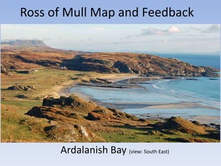
10. Ardalanish Bay with Notable Geological Features
Garnet
Amphibolite
boudinage
Exposure indicating Transition
Unit – Marble Unit boundary
Aird Dubh
Mylonite
Fault displaced “islands”
Exposure with preserved Kyanite – Andalusite
reaction texture
(view: South East)