Sears Hill: Sustainable Neighborhood
•Download as PPTX, PDF•
1 like•92 views

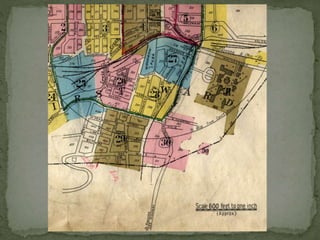
The development of Sears Hill as a residential neighborhood took place in three phases that coincided with the growth of Staunton. The first was spurred in part, by its proximity to the major employers of the working and middle classes. Sears Hill is located immediately south of the C&O Railroad tracks and the commercial downtown area and a few blocks west of the original location of Western State Hospital.West Middlebrook Ave, Sears Hill Road and Robertson Street bound it on the west. It is bounded on the east by Greenville Avenue, on the north by the C&O Railroad tracks, and on the south by Gay Street.

Recommended
More Related Content
What's hot
What's hot (20)
Similar to Sears Hill: Sustainable Neighborhood
Similar to Sears Hill: Sustainable Neighborhood (20)
Recently uploaded
Recently uploaded (20)
Sears Hill: Sustainable Neighborhood
- 2. Sears Hill A Livable, Sustainable Neighborhood HSF advocates the revitalization of Staunton's historic neighborhoods through the utilization of historic preservation practices. Historic preservation inherently relates to the concepts of livable communities by promoting the preservation and restoration of traditional neighborhood elements such as human scaled streets, street trees, sidewalks, utilization of alleys, and of course rehabilitation of building stock. These elements make up the historic landscape of our neighborhoods, defining Staunton's powerful sense of place.
- 3. What does "livable community" mean for Staunton’s historic neighborhoods? The American Institute of Architects has succinctly defined 10 elements of a livable community easily adopted for our use. 1. Design on a Human Scale 2. Provide Choices 3. Encourage Mixed-use Development 4. Preserve Urban Centers 5. Provide Transportation options 6. Build Vibrant Public Spaces 7. Create Neighborhood Identity 8. Protect Environmental Resources 9. Conserve Landscapes 10. Design Matters http://www.aia.org/aiaucmp/groups/aia/documents/pdf/aias077950.pdf
- 4. Livable Qualities of Sears Hill Variety of house sizes fitting diverse incomes Historic architecture ranging from 1850’s – 1940’s National register eligible Excellent potential for historic rehabilitation Historic tax credit incentives available for homeowners (must be listed on the National Register) City Park, green Space, mature trees Community recreation center Excellent public elementary school within safe walking distance Direct walking connection over historic iron bridge to revitalized downtown with shops, restaurants, art galleries, live performance and movie theatres, professional services, city services Less than a mile walk or bike ride to major grocery and all downtown amenities and city services. AMTRAK station within 1/3 of a mile Traditional neighborhood landscape elements Human scaled streets Sidewalks Alleys provide access to off-street parking Long yards with garden space
- 5. Grant - Community Foundation of the Central Blue Ridge The initial project is to update the existing Architectural Survey information and photographs for the Sears Hill Neighborhood. Over the next three years, HSF intends to submit a nomination for the Sears Hill Neighborhood to be placed on the National Register of Historic Places. A new architectural survey will be conducted under the supervision of the Executive Director of Historic Staunton Foundation. The survey will be an ongoing effort, utilizing student interns and volunteers. This will be an educational opportunity to engage in a grass roots preservation effort. Those participating will learn about resource survey, architectural history and identification of architectural elements, and photography. Architectural surveys are important community planning tools. They record existing conditions and allow the community to understand the historic charcter and relationship of properties. Today, surveys are digitized and technologies such as GPS and GIS may be incorporated to help create easily updated, interactive maps. Digitization of the survey will allow consistent updates and sharing of information, therefore providing a better tool for community planning purposes. Steps: 1. Enter existing information into digital forms consistent with National Register Nomination requirements. 2. Conduct an Architectural Reconnaissance Survey, updating the resulting digital forms: •Photograph each property and the neighborhood context •Update architectural descriptions to include changes occurring since 1976 •Obtain GPS/GIS information locating the survey information on an updated map 3. Gather, organize and digitize existing historical information to develop a written historical narrative. ORGANIZATION: HISTORIC STAUNTON FOUNDATION AMOUNT APPROVED: $2,000.00 PURPOSE: SEARS HILL NEIGHBORHOOD SURVEY DURATION: JULY 1,2013-JUNE 30,2014
- 7. North
- 8. North
- 9. North
- 10. The development of Sears Hill as a residential neighborhood took place in three phases that coincided with the growth of Staunton. The first was spurred in part, by its proximity to the major employers of the working and middle classes. Sears Hill is located immediately south of the C&O Railroad tracks and the commercial downtown area and a few blocks west of the original location of Western State Hospital. West Middlebrook Ave, Sears Hill Road, and Robertson Street bound it on the west, on the east by Greenville Ave, on the north by the C&O Railroad tracks, and on the south by Gay Street. Many of the houses appear to be similar in design or scale, however, they are made unique by decorative porch or doorway details. The area is laid out in a fairly coherent grid plan, which helps to unify Sears Hill. The streets are similar in width; most of the houses are set an equal distance from the street and some sort of fencing bound their small front yards. Several of the street including Winthrop, Liberty, and East Peabody retain brick on sand walks and granite curbs. The typical architecture of the district is Vernacular in form with Victorian, Queen Anne, and Italianate characteristics. Vernacular houses are generally not designed by an architect and may be characteristic of a particular area. However, they typically do not exhibit enough of those characteristics to relate to a particular architectural style. (page from Staunton guidelines explaining Italianate, Victorian and Queen Anne styles.)
- 11. Photo list - Garden in yard Park—mature trees Sears House Train Bridge streetscape Alley with garages Sidewalk with patterned concrete Historic Park
- 12. (map of Sears Hill, phase 2 shaded in, not credited) PHASE II (1884 – 1904) The second phase of development is known as the Partlow Addition. This addition is located east of Nelson Street, west of the B&O Railroad, south of Hampton Street and north of Gay Street. As Sears Hill grew along with Staunton, the neighborhood became a self-sustaining community that included a church, grocery stores and a firehouse. The Second Presbyterian Chapel was built in 1893 and was originally located on the east side between Peabody and Liberty Street. In the same year, a volunteer fire company was started and by 1896, the company had its own building that appears to be located on the corner of Hotchkiss and Gooch Street. There were also several grocery stores located at various residents’ homes, including 20 Gooch Street, 4 Nelson Street, and 517 Winthrop Street. The houses built during this time had many Victorian and Queen Anne characteristics and the second two houses on the tour are representative of these trends. 608 Winthrop Street, built between 1884 – 1904 This house has Queen Anne characteristics including a complex gable rood and a gable with fish-scale shingles, an asymmetrical facade with a one bay entrance porch with balusters and a bay window. (4. picture of “512 Winthrop street, built between 1884-1904) This house has Victorian characteristics including a hipped roof with small brackets in cornice, a full-length front porch with sawn millwork balusters and decoration on porch and clapboard siding. 517 Winthrop -Zimmerman’s Grocery 602 Winthrop—1884-1904
- 13. PHASE I (1866 – 1884) (map of Sears Hill, phase 1 shaded in, not credited) The first phase of development of Sears Hill began with the construction of the Sears House by Dr. Robert Lewis Madison in 1866. It is the Tuscan villa style of a bracketed cottage inspired by A.J. Downing. The namesake of the house, Dr. Barnas Sears, bought it in 1867. He added a porch and a five-sided, three-story tower on the west end of the house several years after it was constructed. (line drawing of Sears Hill house) Newton Argenbright and J.J. Ladd also built houses on Winthrop Street in Sears Hill in 1869 and 1875 respectively. By 1877, development ran from Middlebrook Road to Winthrop Street, including the construction on the south side of Garber Street and along Hampton Street. The house built during this time were medium size, two-to-three bay, two-story buildings. The majority had one-story porches running the width of the house with minimal ornamental millwork. Clapboard siding and a gabled, metal roof were also common. The first two houses on the tour provide examples of architectural styles that were common during the first phase of development in Sears Hill. Sears House by Dr. Robert Lewis Madison in 1866 J.J. Ladd built by 1877 built 1877-1884 8 E. Hampton Street, built between 1877 – 1884) This house has Queen Anne characteristics, which include a hipped and gable shingle roof and a porch with a recesses entrance and shingle siding. There is minimal decoration with brackets, molded window and door facings. 2 W. Hampton Street, built 1875” This house has Italianate characteristics, which include a tin, hipped roof with decorative chimneys, bracketed cornice, a full-length porch and a bay window
- 14. (6. picture of “102 E. Hampton Street, built between 1904 – 1909) This house has Italianate characteristics including a full=length porch with decorative brackets and sawn millwork balusters and clapboards. PHASE III (1904 – 1921) (map of Sears Hill, phase 3 shaded in, not credited) The third phase of development occurred with the division of Captain James Marquis’ property located east of Winthrop St., north of Hampton St., west of the B&O Railroad tracks, and south of Sears Hill Road. Half of this property was developed between 1904 – 1909. The homes built during this time were very similar to the pre-existing houses in the neighborhood: two stories, metal roofs, millwork along the porch, and clapboard siding and often reflected Italianate and Victorian characteristics. The homes built between 1921-1929 were slightly different, there were one-story, three bay structures and shingles on the roofs, although clapboard siding was still popular. The last two houses on the tour represent the 1904 – 1909 development. (5. picture of “419 Marquis Street, built between 1904 – 1909) This house has Victorian characteristics including a L- shaped gable roof, decorative millwork on the corner entrance porch and clapboard siding.