Brasilia - Urban City Planning - Human Settlement - UD
URBDP505-Final-Print
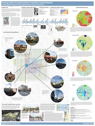
1. Tracing Urban Transformation in Seattle’s Central District
Lindsey Bartley, Steven Fong, Anthony Marris-Swann, Cheryl Tam
We can see that the lot sizes in the neighborhood are quite small, and that a number of the parcels have been subdivid-
ed into smaller parcels. Many of these subdivided parcels have interesting orientations to the street. They may be lo-
cated along an alley instead of facing the street. These smaller lots tend to be residential and contain only one dwelling
unit. Many of the parcels are ordered along a linear grid pattern, but there are a number of parcels that seem to jut out
into the right of way. Commercial properties tend to be larger in size, with some of them stretching for full city blocks.
This is due in large part to surface parking, which occupies a substantial amount of lot space on these properties. Sever-
al of the commercial properties have strange sizes and orientations, with several of them“breaking”the grid pattern of
streets. This is particularly evident in the blocks directly adjacent to our target intersection. Topography may also play a
role in the strange size of some parcels, as the neighborhood and its surrounding area is quite hilly.
The majority of the commercial space in the neighborhood is low-rise, although there are several larger buildings sprin-
kled throughout, with one stretching all the way up to eight stories high. Additionally, several taller buildings are going
to be built along Jackson, replacing the current one-story construction. Common types of housing include: classic box
homes, pioneer houses, Victorian and cottage style homes, as well as low rise apartments. Many of the larger homes
have been subdivided into duplexes. A number of the newer residential properties are three-stories high. These tend to
be tall and narrow homes, built to capture the view of the Seattle skyline.
We can see that a good number of commercial structures in the neighborhood are pre-World War II. We can also see
that there are a number of newer commercial properties that have been built in the past 20 years, but the majority of
the building stock has yet to be updated. There are several parcels slated for rebuilds in the coming years. The buildings
are mostly made of wood, although there are some brick or concrete structures. Many of the older homes have intricate
detailing on the windows and trim. Many of the newly constructed homes are built in a modern style with large glass
windows and sleek facades.
The zoning in this area is heavy on low-rise multifamily housing, although there are a number of properties zoned for
single family housing as well. Many of the parcels zoned for neighborhood commercial also contain residential units
above the commercial. These zones allow neighborhood businesses to make efficient use of their space and can provide
a live/work environment for owners. Some of the newer developments also include mixed-use commercial and multi-
family, and more development of this type is slated to be built in the neighborhood in the near future. It’s important to
note that zoning regulations are not always an accurate representation of what is currently built, but serve as a vision for
future neighborhood development. There is a lack of green space in the neighborhood with limited options for future
development of park land.
Seattle’s Central District has historically been home to minority
groups. At the beginning of the 20th Century, it was a predomi-
nantly Jewish Neighborhood. Japanese immigrants arrived later
and also moved to the area. Following the Japanese internment
during World War Two, the Central District became predominantly
African-American. The National Housing Act of 1936 brought the
practice of redlining to Seattle, which played an important role
in defining the neighborhood as an African-American cultural
center. During the 1940s and 1950s, there were numerous jazz
clubs populating Jackson Street, many of which hosted the likes
of Quincy Jones, Ray Charles and Ernestine Anderson. Economic
decline plagued the neighborhood and the city at large during
the 1970s and 1980s, but recent growth has spurred redevelop-
ment in the neighborhood, leaving some concerned about gentri-
fication and the loss of individual neighborhood character.
Evolution of Central District: 1850-2016
STATISTICAL SNAPSHOT
According to 2016 data:
Area: 3.558 square miles
Population: 42,231
Population density: 11,868 /square mile
(compared to 7,779 / square mile in Seattle)
Median Rent: $1,059/ month
Owner Occupied Homes: 49.2%
Renter Occupied Homes: 50.8%
A GENTRIFYING CENTRAL DISTRICT
According to data for 2000 (change from 1990-2000):
Census Tract 88 (east of 23rd Avenue S)
Population: 3,506 (+228)
Median Home Value: $268,000 (+120%)
Bachelor’s Degrees: 38.6% of adults (+23.9%)
Census Tract 89 (west of 23rd Avenue S)
Population: 4,596 (+807)
Median Home Value: $282,500 (+72%)
Bachelor’s Degrees: 46.0% of adults (+14.9%) Disappearing minorities in the Central District
Source: Seattle Times
A woodcut featuring illustration of
struggle for equal rights
Source: Voice of Action Feb 12, 1935
Newspaper ad featuring Ray Charles’
performance
Source: Northwest Enterprise Jan 11, 1934
Jim Crow Protests
Source: Seattle Municipal Archives
Planned development
of 2309 South Jackson
Street
Source: Vulcan
Mapping the results of redlining
Source: Seattle Municipal Archives
INTRODUCTION
We have selected to examine a section of Central District surrounding the intersection of 23rd Avenue
South and South Jackson Street. This particular area represents a major crossroads in the neighbor-
hood and is home to high-traffic commerical and community gathering points. It, along with adjacent
neighborhoods, will also be the site of much change and development over the next few years with the
planned Judkins Park light rail station just one mile due south as well as Vulcan Real Estate’s purchase of
several parcels surrounding this intersection.
CURRENT ZONING
LOT SIZE (SQUARE FEET)
BUILDING HEIGHT
YEAR BUILT
URBAN FORM ANALYSIS MAPS
New mixed-use development has dramatically changed the
built form of the neighborhood, both in terms of housing
forms and commercial vibrancy. These two photos from the
23rd Avenue South and South Jackson Street intersection
exemplify the diverse urban form of the area.
The housing stock of Central District includes a
spectrum of architectural styles representative
of distinct eras. As seen in this series of photos,
within a one block radius, one can find:
• Craftsman
• Art deco
• Modern and geometric
• Bungalow
The street network in this neighborhood is primarily
grid-based, with some variation, especially around
large parcels on major thoroughfares. Despite the
presence of multi-modal transport infrastructure,
car-oriented commercial development still domi-
nates. Surface parking is abundant.
While Starbucks is characteristically an evi-
dence of gentrification, this particular shop at
the corner of 23rd Avenue South and South
Jackson Street continues to serve as an import-
ant meeting place and community center.
The area west of 23rd Avenue South sees
a mix of densities and land uses. A quick
walk along Jackson Street yields starkly
juxtaposed views of newer strip-mall
style commercial development, small
businesses, historic religious institutions
and single family homes.
SOURCES
Historical Context Data:
City-Data: http://www.city-data.com/neighborhood/Central-Area-Seattle-WA.html#ixzz4QrPOp53f
Seattle in Progress: https://www.seattleinprogress.com/project/3022791/page/1
Seattle Municipal Archives: https://www.seattle.gov/cityarchives/exhibits-and-education/online-exhibits/seat-
tle-open-housing-campaign
Seattle Times: http://www.seattletimes.com/pacific-nw-magazine/seattles-vanishing-black-community
Seattle Times: http://www.seattletimes.com/seattle-news/data/historically-black-central-district-could-be-less-than-10-
black-in-a-decade
University of Washington: http://depts.washington.edu/civilr/segregation_maps.htm
Urban Oasis: http://www.urbanoasis.org/projects/holc-fha/digital-holc-maps/
Analysis Map Data:
King County Department of Assessments: http://info.kingcounty.gov/assessor/datadownload/default.aspx
King County GIS Data Portal: http://www5.kingcounty.gov/gisdataportal/default.aspx
Future Scenario Data:
Seattle Department of Construction & Inspection: http://www.seattle.gov/dpd/AppDocs/GroupMeetings/DRProposal-
3022791AgendaID5850.pdf
Sound Transit: http://www.soundtransit.org/Projects-and-Plans/East-Link-Extension/Stations/Judkins-Park-Station
Map Data:
Google Maps
Open Street Map
HISTORICAL CONTEXT AND CHANGES
A WALK AROUND THE NEIGHBORHOOD
URBDP 505: The Urban Form December 2016
Our specific study area covers approximately nine blocks, four of which are
found along 23rd Avenue South between East Fir St and South King Street, and
the rest located on either side of South Jackson Street between 23rd Avenue
South and Martin Luther King Jr. Way South. This study area extends beyond a
quarter section context area; thus, we selected to use a half-mile square section
as our designated context. The key to the left corresponds with the map below,
which serves as the representative platform for our analysis.
We selected two time slices for our historical analy-
sis: (1) 1940s-1950s and (2) 1990s-2000s. The post-
World War II era was a high point in the influx of
African-Americans to the area as a result of redlining
and neighborhood covenants. Regardless, during
these decades, Central District enjoyed an especial-
ly concentrated period of urban renewal leading to
rich community and cultural development. Between
the 1990s and 2000s, gentrification had entered the
neighborhood in full force and caused rapid redevel-
opment and dramatic shifts to the demography of
Central District’s residents. Both of these time points
represent key change periods that, for better or
worse, have contributed to Central District’s continual
evolution as a vibrant Seattle neighborhood.
This 1936 map from the Home Owners’’Loan Corpo-
ration displays Central District in red, indicating that it
was a“hazardous”area.
Source: urbanoasis.org
THE FUTURE OF CENTRAL DISTRICT, CIRCA 2050
As evidenced in tracing urban transformation to date, Central District has already been undergoing
much change to its urban morphology. An increased demand for housing has led to the upzoning
along many major roads and intersections, especially on the corner of 23rd Avenue South and South
Union Street as well as our focus point of 23rd Avenue South and and South JacksonStreet. The new
570 unit mixed use Vulcan development at 2309 South Jackson epitomized the current trend of in-
creased density and height in one of Seattle’s oldest residential neighborhoods.
CULTURE PRESERVATION AND AFFORDABLE HOUSING
One of the enduring criticisms of redevelopment in Seattle overall is just how dra-
matically it changes neighborhood character. In most cases, the existing demo-
graphic is slowly displaced by wealthier individuals looking to move into the newest,
hippest spot in town--Capitol Hill’s Pike-Pine corridor is a prime example of this. The
Central District is home to Seattle’s largest African American community, and already
they have seen increased rents start to drive them out of their neighborhood to
more affordable areas south of the city. It will be interesting to see whether or not
the city’s mandatory affordable housing requirements will be enough to curb the
economic interests of private developers as the numerous mixed-use, multifamily
housing complexes continue to spring up along parts of 23rd Avenue South.
EXPANDING TRANSPORTATION
Another one of the driving factors of the change in the Central District’s urban form is the proposed
arrival of the Judkins Park Light Rail station, with its main entrance planned at the corner of Rainier Av-
enue South and 23rd Avenue South slated for opening in 2023. While located at the very southern end
of the neighborhood, the new Light Rail station will most likely reach as far north as Jackson in terms
of attracting local ridership. This increased accessibility is further enhanced by the planned extension
of the First Hill Streetcar along South Jackson Street so that it reaches all the way to 23rd Avenue. Our
focal intersection of 23rd & Jackson, and the corridor of South Jackson Street itself, will likely be the
most greatly impacted section of Central District. The closest existing parallel one might find to the
future version of Jackson Street is Broadway on Capitol Hill with its oversaturation of transport infrac-
ture in the form of the Streetcar, Light Rail station and numerous bus routes. However, the east-west
nature of the Jackson Street Streetcar extension will likely serve as a more effective city connector than
its existing counterpart, linking the Central District with the International District, Pioneer Square, and
the rest of Downtown. This expansion of transportation networks will make the Central District a much
more attractive neighborhood, further pushing the redevelopment of the neighborhood, especially in
the southern end. Once again, managing this growth will be paramount to preserving and enhancing,
as opposed to replacing, the existing character and culture of the Central District .
These renderings (left, top and right) from Vulcan Real
Estate’s planned redevelopment of our focus intersec-
tion of 23rd Avenue South and South Jackson Street
provide a foretaste of the dramatic shifts that will occur
in the neighborhood over the next few years. By 2050,
we suspect that this style of built form will dominate
and overtake existing historical structures.
Source: Vulcan
On the far right, planned expansions to Seattle’s public
transit system, including a Judkins Park Light Rail
station (top right) and an extension to the First Hill
Streetcar along South Jackson Street (bottom right).
Source: Sound Transit