1. GEOSTEERING
An essential part of drilling today is Geosteering. From building the curve, to landing and
proceeding through the target interval requires a precise understanding of the location of the
wellbore relative to lithology, in addition to the ability to identify small geologic changes. At Impac
Geosteering, we provide a 24/7 Geosteering Service that uses the most advanced software and
techniques available to understand those changes.
The service is provided by highly trained geologists that work very closely with the logging crew
and the customer to assure a continuous understanding of the subsurface relative to the wellbore.
By coupling Geosteering with Mud Logging, Impac Exploration Services is able to provide a more
detailed geologic service than provided by using Geosteering or Mud Logging alone. It is the close
inter-relationship between the logger on the well and the Geosteering geologist that provides the
extra insight which is so critical in complex horizontal environments.
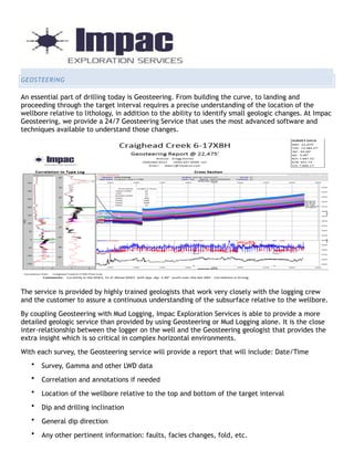
With each survey, the Geosteering service will provide a report that will include: Date/Time
• Survey, Gamma and other LWD data
• Correlation and annotations if needed
• Location of the wellbore relative to the top and bottom of the target interval
• Dip and drilling inclination
• General dip direction
• Any other pertinent information: faults, facies changes, fold, etc.