
Recommended
More Related Content
What's hot
Viewers also liked
Similar to Providing quality geoscience services for mineral exploration and mining
Similar to Providing quality geoscience services for mineral exploration and mining (20)
Providing quality geoscience services for mineral exploration and mining
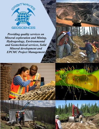
- 1. Providing quality services on Mineral exploration and Mining, Hydrogeology, Environmental and Geotechnical services, Solid Mineral development and EPCMC Project Management
- 2. Head Office 605, 1-200 North Service Road West Oakville Ontario - L6M 2Y1, Canada Phone: +1 647 801 3812 Fax: +1 905 230 3812 Email: info@orbitwaves.com URL: www.orbitwaves.com
- 3. About US Orbitwaves professionals have been involved on projects in North America, South America, Australia, Asia, Europe and Africa At Orbitwaves, we are committed to providing a full range of consulting services in geosciences to mineral exploration and mining industry, water resources and civil engineering sector including government establishments. We also offer professional advice to banking and financial institutions to guide their investment decisions in mining. We manage projects right from inception to completion. Our engagements include program planning and design, program execution, including fieldwork, data collection (geochemical, geological and geophysical data), design and implementation of quality control and quality assurance procedures, supervision of programs, data compilation, building of geological and mining software compliant database, data analysis, interpretation and reporting. We also use diverse GIS softwares for data visualization, modeling and presentation. At Orbitwaves, we integrate our knowledge and understanding of geostatistics and mining with strengths in structural and ore deposit geology combine with extensive experience in mineral resource estimation to develop geological models as well as industry standard (JORC and NI 43- 101) compliant resource estimates. Our Geophysical expertise cover both small and large scale project of most geophysical survey for mineral exploration, groundwater, oil and gas, geotechnical investigations and civil engineering purposes. We conduct site investigations to determine ground conditions, underlying geology and hydrology using a wide range of drilling, soil sampling, testing and analysis to determine the ground properties and its suitability for civil engineering and other proposed uses. At Orbitwaves, we handle everything on borehole from inception to completion. We use state of the earth geophysical equipment to determine the best location for optimal borehole performance. Our extensive range of modern and well maintained drilling rigs and associated equipment are manned by highly skilled, well trained and certified engineers to ensure the best services are provided. We optimize dataset by creating and managing a robust database. We use world leading GIS softwares to process dataset for 2D and 3D visualization then integrate geology, geophysics and geochemical techniques to analyze and interpret models for true understanding of the underlying geology and to make informed decision on project direction. Our Project Management team members are well experience at initiating, planning, designing, executing, monitoring and controlling mining related projects, including mineral processing plants, mines, refineries, dams, highways, most EPCMC projects and general construction. We work with clients and all stakeholders to deliver high quality, cost effective and timely products and services. Orbitwaves Geosciences was first incorporated in Canada but now maintains regional operation offices in Asia, Africa, Australia and South America. As a precursor to providing high quality, cost effective and timely services to our esteem clients, we sought after the best hands in the industry. Our multi-disciplinary team of geoscientists and engineers consists of registered professionals with many years of field and management experience in addition to extensive education and training in their respective area of specialties.Geologist observing visible gold in core sample
- 4. Our Services Geological Services We handle all aspect of geological services for both greenfield and brownfield mineral exploration projects, including fieldwork, database management, analysis and interpretation as well as resource development Geophysical Services Our Geophysical expertise cover both small and large scale project of most geophysical survey for mineral exploration, groundwater, oil and gas, geotechnical investigations and civil engineering purposes. Geotechnical Services We conduct site investigations to determine ground conditions, underlying geology and hydrology using a wide range of drilling, sampling, testing and analysis to determine the ground properties and its suitability for proposed uses. Hydrogeological Services Mining Services Environmental Services GIS and Database Management Project Management We handle everything on borehole from inception to completion. We use state of the earth geophysical equipment to determine the best location for optimal borehole performance. Our extensive range of modern and well maintained drilling rigs and associated equipment are manned by skilled, well trained and certified engineers to ensure the best services are provided. We optimize dataset by creating and managing a robust database. We use world leading GIS software to process dataset for 2D and 3D visualization then integrate geology, geophysics and geochemical techniques to analyze and interpret models for true understanding of underlying geology and to make informed exploration decision. We are well experience at initiating, planning, designing, executing, monitoring and controlling mining related projects, including mineral processing plants, mines, refineries, dams, highways, most EPCMC projects and general construction. We work with clients and all stakeholders to deliver high quality, cost effective and timely products and services We provide services that form a bridge between exploration and actual mining. We partner with larger consulting firms to deliver quality services including reserve estimation, Geotechnical Investigation, preliminary economic assessment, metallurgical studies, feasibility Studies, mine Planning and Grade Control. At Orbitwaves, we believe that a structured holistic approach at all levels of society, including mineral exploration and mining industry, is needed to ensure best environmental practices are adopted and implemented across the board and we help our clients to meet their environmental protection obligations through a wide range of our environmental service.
- 5. GEOLOGICAL SERVICES Orbitwaves Geosciences has the capacity to offer professional services on both grassroots and advanced exploration projects for metallic mineral, industrial mineral, coal as well as oil and gas. We cover virtually all aspect of exploration businesses including research and project generation, project planning and design, project execution and supervision, trenching and all kind of drilling, property and regional scale prospecting and geological mapping, property and regional scale soil and stream sediment sampling, ore deposit modeling and resource calculation, writing NI 43-101 compliant report and conducting project audit. We provide services on property evaluation and due diligence investigation which takes into consideration economic, social-political and environmental factors. At Orbitwaves, we don’t reinvent the wheels. We usually begin every project by carrying out a thorough review of previous work including digitizing historic data such as hand- written drilling program, hard-copy soil grids, mapping and sampling program. All information are transformed to digital files and integrated to build a digital compilation and a query-able exploration database for the purpose of analysis, interpretation and development of exploration guidelines. Our exploration team members are highly proficient in most exploration, mining and GIS softwares including ArcGIS, MapInfo, Vulcan, Gemcom, Amine, Leapfrog and many more. Prospecting At Orbitwaves, we take advantage of the traditional prospecting, reconnaissance traverse and communication with the locals to quickly identify mineral showings and exploration prospects. Our prospectors have many years of hands-on experience and have developed trained eyes and eye-for-ore in the course of their service. Utilizing their services for reconnaissance rock sampling, heavy minerals and stream sediment sampling, soil sampling and terrain assessment have proven to be a very quick and cost effective means of developing exploration target. Mapping and sampling Considering the huge variation in geology of different properties and various mineral deposits, Orbitwaves design project specific mapping and sampling program that enables our experience geologists adequately capture geological information on properties. Our exploration team has extensive experience on both greenfields and brownfields projects including mapping of open pit and underground mines. We utilize various portable hand- held devices to digitally capture data including photo and location. In addition to the traditional soil and stream sediment sampling, we have developed expertise in collection of mobile metal ions (MMI) and organic samples. Our samples are analyzed by highly reputable and accredited commercial laboratories under strict QA/QC protocols. Under the supervision of a project geologist, the resulting data are integrated with geophysical and geochemical data to build a detail compilation and query-able exploration database which ease analysis, interpretation and development of further exploration program. Drilling We leverage on our extensive knowledge and experience in the field and project management to design project specific and effective drilling programs for exploration target testing, ore definition drilling and resource development drilling. We have managed numerous diamond-drills, rotary air blast (RAB) drilling and reverse circulation (RC) drilling. We have handled numerous drilling programs, starting from project initiation, design and planning, budgeting, placement of contract tender, contract negotiation and selection of contractors, hiring of support staff, program scheduling, execution and supervision, budget monitoring and control, purchasing and logistics, core logging, assay data compilation and validation, development of database, data analysis, interpretation and preparation of technical report.
- 6. Mineral Resource Estimation At Orbitwaves, we integrate our knowledge and understanding of geostatistics and mining with strengths in structural and ore deposit geology combine with extensive experience in mineral resource estimation to develop geological models and resource estimates. We have built models and developed resource estimate for many mineral commodities and deposit types. Where necessary, we partner with reputable individuals and companies to ensure our client get the high quality and cost efficient service. Our strength includes; Assessment of QA/QC procedures and controls Creation of and analysis of geological and assay sections and level plans Creation of 2D and 3D geological, structural and mineralization models Statistical and geostatistical analyses Resource estimation, variography and classification Resource validation and categorization NI43-101 resource statement NI43-101 technical reporting Report writing Orbitwaves identify, attracts and retain the best hands in geosciences in her team. Our geoscientists are registered professionals defined as Qualified Persons (QP) by the National Instrument (NI 43-101). They are very qualified to write National Instrument 43-101 compliant technical reports. At Orbitwaves, we understand the importance of standard technical reporting and we have always applied the required protocols and due diligence. Technical reports are recognized by different names and are regulated differently in various jurisdictions. The common names and their respective jurisdictions are as follows: Competent Person’s Reports – (United Kingdom, America and Australia) Qualified Person’s Reports – (Canada) Mineral Expert’s Reports – (Russia and SE Asia) It is very important to have very good knowledge about reporting requirement of the various jurisdictions to ensure reports are fully compliant. Orbitwaves professional geoscientists are very conversant with the requirements and regulations of the different jurisdictions having completed many of such reports in many jurisdictions. Our reporting experience spans over a wide range of metals, industrial minerals, coal as well as oil & gas. We have prepared reports for various purposes such as listing of company on the stock market, exploration project disclosure and disclosure of mineral resources. Geological Modeling Services Orbitwaves boast of a team of experts with expensive experience in the area of GIS. Our staffs are highly proficient in many GIS softwares such as ArcGIS, MapInfo, Surpac, Gemcom, Vulcan, Leapfrog, Amine and many more. Our highly-skilled GIS team members are capable of transforming exploration data into both 2D and 3D model for easy visualization, analysis, interpretation, resource evaluation, presentation and exploration planning purposes. Exploration Diamond Drilling in Northern Saskatchewan
- 7. GEOPHYSICAL SERVICES At Orbitwaves, we recognize the fact that most geochemical and geological program will provide very detail information about the subsurface but on a very small scale and in some cases, such as drill hole, on a specific location. On the contrary, a well- designed geophysical program can provide critical information about the subsurface continuously over a wide range of land at an amount that is always lower than other exploration techniques. Geophysical survey therefore represents a very strong and cost effective tool for quickly eliminating non-prospective part of a property and for generating exploration targets. Orbitwaves boast of geophysical crews that are highly experience in a wide range of geophysical techniques that are applicable to various mineral commodities, terrain and geology. Our geophysical team diligently works with our clients to analyze the survey objectives, technically consider all the variable parameters and take advantage of their wealth of experience to suggest the most suitable method from the wide range of geophysical techniques. We partner with highly reputed companies and contractors across the world to provide the best services in geophysical survey. Our specialty covers airborne and ground survey including drill/boreholes. Our frequently used methods include Electromagnetic Method, Potential Fields, Electrical Methods, Ground Penetrating Radar (GPR), Borehole Geophysics, Airborne Geophysics and Seismic survey. We leverage on our wealth of experience in all aspect of geosciences, including geophysics, geology and geochemistry, to integrate geophysical data with geological, geochemical, borehole, hydrogeological and any other available data and build a robust database and compilation that can be analyzed in many perspectives. Our geophysical consulting services cover a wide range of disciplines. We have worked for private companies, publicly traded companies and government establishments on projects that spread across mineral exploration and mining, oil & gas exploration, civil engineering and environmental services, groundwater exploration and investigation, aggregate exploration and geotechnical engineering investigations. We have consulted beyond the shores of Canada to Asia, Africa, South America and Australia. Our services include design and management of geophysical surveys of all sizes, quality control, data compilation and processing, modeling and interpretation of geophysical data. We have the capacity to manage geophysical project of any size. “Geophysical exploration techniques have continuously proven to be a reliable and cost effective method of quickly screening exploration properties to discriminate between prospective and non- prospective areas” Walking magnetic geophysical survey in the White Gold District, Yukon, Canada Airborne Geophysical Survey Airborne Geophysical Survey Airborne Magnetic map
- 8. GEOTECHNICAL SERVICES The importance of assessing the engineering properties of a site before embarking on any constructions work cannot be over- emphasized. Since the properties of soil, bedrock and distribution of geological structures in an area determine the overall engineering properties, geotechnical investigations are required to gain understanding of the suitability of any property for a proposed construction work. At Orbitwaves, we provide the best geotechnical services and site assessment in the determination of ground conditions, underlying geology and hydrology using a wide range of methods. Our geotechnical work flow typically begin with a background review of the geologic nature of the construction site and usually followed by specifically designed subsurface investigation program to characterize and partition the subsurface materials and geologic structure. We utilize various types of excavation equipments such as backhoes, drill rigs and hand operated equipment for test pits, trenching, borings and drilling to reach our targets and to collect samples and data. In addition to field data, samples are subjected to both routine and customize laboratory analysis and tests in order to determine their physical and engineering properties. Our scope of work also covers site investigations for risk assessment to humans, properties and environment. We have the expertise to determine the possibility of occurrence of natural disasters such as ground failures including landslides, sinkholes, karsts, soil liquefaction, debris flows and rock falls. Our site investigation include assessment of situations and activities at a site to determine whether they presently, or may potentially constitute source of environmental contamination. In the event a potential source of contamination is discovered, we evaluate and accurately predict the likely area that may be affected and recommend preventive measures. Depending on the type of construction project, Orbitwaves geotechnical team possesses the technical knowhow to design assessment program specific for the varying civil requirements of projects and structure. Upon completion of site assessments, geotechnical reports are prepared by qualify geotechnical staff to present field and laboratory data. Analysis, interpretations, conclusions and recommendations are also presented in the report to assist architects and engineers to make inform decisions on the project design and land use. Our geotechnical staff leverage on their extensive years of experience to provide high quality, cost effective and timely professional geotechnical services even on complex geotechnical projects. We handle a wide range of geotechnical assessment of sites for civil engineering work as well as construction of residential, commercial and industrial properties.Motorize auger drilling and sampling for geotechnical testing and analysis Ground gas content analysis - Geotechnical investigation
- 9. HYDROGEOLOGICAL SERVICES We handle everything from inception to completion and do not leave until we are extremely satisfied with client's well performance. Our technical team offers a complete range of ancillary borehole related services including; Borehole drilling Pumping point and reservoir tank installation Borehole refurbishment or Decommissioning such as development, acidisation, iron removal, scrubbing, air lifting, chemical treatment, telining, submersible pump replacement, abandonment to environment agency standards Borehole Surveying and Aquifer Testing including CCTV survey, verticality & positioning survey, test pumping, monitoring, water analysis, packer testing, hydro fracturing Pump and Control Systems including supply, installation and management Water Treatment including supply, installation and management. Our dedicated team of experts are always delighted to assist with any question. Contact us today for a free, no obligation quotation Orbitwaves borehole drilling team have many years of hands-on experience in the industry and are very competent to give her clients expert advice and services on their borehole need. At Orbitwaves Geosciences, we don't just drill boreholes, we have state of the earth geophysical equipment to carry out property survey and determine the best location for optimal borehole performance. Orbitwaves has an extensive range of modern and well maintained drilling rigs as well as associated equipment that are manned by highly skilled, well trained engineers who hold all necessary trainings and certifications to carry out their work and safely operate all plants on site. Overhead reservoir tank of a motorize borehole completed for Kogi State Government
- 10. MINING SERVICES These services are very crucial to exploration companies as it provides the information required to advance exploration projects to the next phase of operations and form a bridge from exploration to mining. Our mining consulting team consists of seasoned professionals with extensive experience. In addition to extensive in- house skills, Orbitwaves partner with larger engineering and mining consulting firms to deliver top quality services to our clients. Our mining consultants have completed mining services at various levels on many projects around the world. The following is a list of few among many mining services we provide: Reserve estimation and audit – At Orbitwaves, we specialize in Mineral Reserve audits and estimates for feasibility level studies and operational mines. The technical audits help our clients to ensure that Mineral Reserves have been estimated according to standard mining industry practice (NI 43-101, JORC) or to obtain an independent assessment of their estimates for either internal purposes or for third parties, such as financial institutions or other interested mining companies. We are well equipped with state of the art software, geology and mine planning software to help us provide cost effective and reliable services. Geotechnical Investigation – When Orbitwaves is involved in the early stage of exploration program, geotechnical data are collected at the onset. We also advise our clients to initiate geotechnical investigations as soon as possible in an exploration program in order to avoid expensive duplicate drilling of boreholes. For mine planning purposes, we consider rock quality designation and evaluation of the point load strength for both hand specimen and borehole samples. We also carry out structural mapping of rock exposure, Measurement of water levels in exploration boreholes and measurement of flows from artesian boreholes. We also handle sensitivity analysis of known failures by altering the variables such as the position of the piezometric surface or material strength to establish typical shear strength values for design from back analysis of existing footwall failures. Preliminary Economic Assessment – Our in house professionals provide a full scoping studies for project based on mine optimization and analyses of sensitivity variable such as mining costs, mining recoveries, milling costs, milling recoveries, commodity pricing etc in order to determine the potential economics of developing a mine and possible mining methods. These processes help Orbitwaves to prepare NI 43- 101 compliant mining reserves from geological resources as well as mining schedules and net present value (NPV) cash flows Open pit coal mining Geological model orebody and mine plan An Underground coal mine Gold nuggets recovered from placer mining in Yukon, Canada
- 11. Metallurgical Studies – Orbitwaves experience professionals conduct metallurgical studies and testing of ore samples to establish the most effective processing methods to maximize metal recovery. The result are used to help our clients design commodity specific flow-sheets for metallurgical and mineral processing. We review existing flow-sheet designs and specific project characteristics, make recommendations and modify designs as needed, help with implementations to optimize efficiency and cost effectiveness. We also work in early stages with companies to implement new systems from the scratch while coordinating with client process system designers and implementers to ensure flow-sheets work optimally for specific projects. Feasibility Studies – At Orbitwaves, we have the expertise required to advance projects from Preliminary Assessment through Pre-Feasibility to Feasibility Study. In collaboration with notable engineering firms, our expert personnel ensure all aspect of operations are studies in detail and data collected to build project specific economic model. The model is then used to perform economic analysis of the project including cash flow analysis, sensitivity analysis, mine production rate, mine life, metal recovery rate, capital cost, net present value, internal rate of return, payback period and many more. The process has been very helpful in assessing project viability and comparison of one project with another. Mine Planning – With the aid of most advanced software such as GEMCOM, A-mine, Leapfrog and many more, our highly experience personnel consider many mining scenarios and variables to provide the best mine design, mining method, annual and life-of-mine production, equipment needs and personnel requirements. We also provide business process audits, open pit optimization and strategic mine planning, mine scheduling and fleet optimization. Orbitwaves also provide onsite reviews of processes, due diligence and technical audits and make recommendations where improvement is necessary to maximize efficiency and minimize costs. Grade Control – In order to minimize the difference between planned production and actual production parameters, Orbitwaves provides proper grade control through an onsite review of processes such as, sampling methods, stockpiling and blending, ore type differentiation and mining selectivity. We also provide a reconciliation analysis by analyzing results from resource models based on exploration drilling and compare them to actual data collected from blast holes and plant feed records and make recommendations for improvement where applicable. Open pit gold mine at Primero Mining Corp, Timmins, Northern Ontario, Canada
- 12. ENVIRONMENTAL SERVICES The level of awareness on environmental issues has increased significantly in recent years and Orbitwaves believe that a structured holistic approach, on all levels of society including exploration and mining companies, is needed to ensure best environmental practices are adopted and implemented across the board. There is no doubt that a structured approach to environmental protection is the best way forward. In order to help our clients meet their environmental protection obligations, we have added renowned experts in the field to our team With highly skilled and experience professionals, Orbitwaves provides a wide range of environmental services to support a thorough understand and compliance with increasingly difficult regulatory policies, environmental concerns and standards in the exploration and mining business. The level of awareness on environmental issues has increased significantly in recent years and Orbitwaves believe that a structured holistic approach, on all levels of society including exploration and mining companies, is needed to ensure best environmental practices are adopted and implemented across the board. There is no doubt that a structured approach to environmental protection is the best way forward. In order to help our clients meet their environmental protection obligations, we have added renowned experts in the field to our team. In collaboration with our partners and major environmental services companies, Orbitwaves is able to offer tailored environmental management services covering a wide range of specialties. We have leveraged on the extensive experience of our team members to provide highly innovative environmental consultant services to many companies and government agencies in the following areas. Environmental baseline program design Management of environmental programs, Environment Impact Assessment (EIA) Environmental and Social Impact Assessment (ESIA) Development of proposal requests and review of RFP submissions Environmental Audits Environmental risk identification Assessment of environmental contamination and implementation of remediation plan Contamination clean-ups Waste management and remediation Acid rock drainage characterization and management Conducting baseline environmental studies Environmental permitting and approvals for exploration and mining programs Environmental liability assessments and financial assurance Environmental compliance monitoring: audits, reviews and recommendations pH testing and water sampling for environmental contamination testing
- 13. GIS AND DATABASE MANAGEMENT GIS also provides the platform for managing mineral titles, land records, and associated information. GIS enables accurate plotting of land and mineral title data from corporate or government sources. It also provides digital access to properties for their occupancy status, visualization of competitor activity and potential stakeholder conflicts as well as tracking of regulations and obligations on active leases. GIS is extensively used to actively monitor the environmental impacts that may be caused by human activities. Geologists have used GIS for environmental and geotechnical investigation and to analyze and map soils, vegetation, surface hydrology and groundwater. At Orbitwaves, we usually begin every project by carrying out a thorough review of previous work including digitizing historic data such as hand-written drilling program, hard-copy soil grids, mapping and sampling program. All information are transformed to digital files and integrated with current data including geological, geophysical and geochemical data to build a digital compilation and a query-able exploration database for the purpose of analysis, interpretation and development of exploration guidelines As mineral deposits become increasingly difficult to find, so the need for quality data and ability to optimize them become increasingly indispensable. Mineral exploration geoscientists use diverse types of datasets, ranging from basic geological data to hyperspectral airborne and multispectral satellite imagery, to search for mineral deposits. Geographic Information Systems (GIS) provide a sophisticated toolset for integrating, analyzing and displaying technical data. The possibility of integrating geospatial data and exploration techniques has helped geoscientists to understand and predict mineral prospectivity, develop exploration guidelines and to determine economic potentials with unprecedented accuracy. Mining companies use GIS to analyze mine data for engineering design and production management, visualization of models in 2D or 3D, generate reports and maps on site and update corporate database. Our GIS team consists of experience professionals have the skills and knowledge for setting up, validating and developing query-able databases as well as organized workflows to create cutting-edge exploration strategies. We effectively designed databases to organize information such that it may be analyzed as a whole or partition into discrete layers or parts in order to assess a larger picture or target specific items of interest within the database. We custom build databases to suit the peculiar need of operations in various geosciences projects. Our experience professionals compile, verify and manage large quantities of existing data into a highly useful database format. 3D geological representation of exploration drilling result 3D geological model of exploration drilling, the orebody and the mine plan
- 14. Orbitwaves offers innovative computer-based data integration, management, and presentation services that can be applied to the entire spectrum of the mineral exploration and mining industries, from grass-roots reconnaissance maps to the preparation of auditable databases for feasibility studies. We have the capacity to promptly process large volumes of data and provide basis for real-time planning and decision making. Since mineral exploration has become progressively more difficult, focusing on covered and deeply buried deposits and brownfields targeting, Quality 3D geological modeling, analysis, and interpretation of data have become very important. At Orbitwaves, We develop 3D models to provide critical platforms for understanding the characteristics and the environments of ore deposits, thereby reducing exploration risk. We are well experience working across a range of project scales and business needs, from mineral exploration to resource modeling and geotechnical engineering. Our team works with a broad spectrum of modeling technology and data types in order to create and deliver meaningful, client-driven models that serve as the basis for decision making in exploration targeting, resource estimation, geotechnical evaluation and engineering services. Our GIS experts incorporate structural and stratigraphic interpretations from previous studies and exploration programs in the models, along with fabric measurements, regional geology, drill core logs and geophysical data. An iterative process of classification, boundary definition and relationship mapping in 3D GIS adds significant new value to the existing data and provides a framework for modeling that is embedded with all the original geospatial and geological knowledge available for the target zone. We are highly skilled at managing complex modeling projects from setting concrete objectives through to detailed model design. We work directly with clients to provide valuable 3D models and interpretation in common formats for the easy communication of results and ideas. Orbitwaves provide the industry-leading capability for the construction and interpretation of 3D geological models. We leverage on our knowledge and experience on a wide range of geological, geophysical, geochemical, and geotechnical techniques and tools to build integrated models of complete geological frameworks. We use world leading GIS softwares to process dataset for 2D and 3D visualization then integrate geology, geophysics and geochemical techniques to analyze and interpret models for true understanding of the underlying geology and to perform resource evaluation, presentation and exploration planning. With the combination of company generated and commercial datasets, such as LiDAR and aerial imagery while employing the use of state of the art software and innovative techniques we are able to offer 3D modeling and visualization services that can be used to greatly enhance and improve exploration planning in an office environment before embarking on field operations, thereby greatly saving on time, expense and cutting-down on environmental impact. Our GIS professionals are highly proficient in most GIS softwares including ArcGIS, MapInfo, Vulcan, Gemcom, surpac, Amine, Leapfrog, geosoft and many more. We also compile and interpret data while exploration activities are in progress to ensure the quality and adequacy of work program. The data bases are always carefully maintained, updated and verified for quality, reusability and future references. Orbitwaves GIS specialists have successfully planned and executed mineral exploration projects using various innovations and effective exploration techniques for different clients. We have expertise in target creation and target development for mineral exploration projects and to provide necessary data bases and graphic presentations. 3D Geological model of an orebody with geophysical signature
- 15. PROJECT MANAGEMENT and the project team dissolved upon project completion. We believe in continuous improvement and have always expressed it by developing a closure report to document how the project had performed against the project management plan and our clients have published success stories on how the lesson learned from the report have helped their subsequent projects. At Orbitwaves, we have extensive experience and resources for providing full project management services for all range of project sizes across all disciplines including mineral exploration, mining industries, oil and gas, civil engineering and many more. We have provided quality services to clients across the world. We have reputation for effectively coordinating multi- discipline teams and continuously monitoring progress and costs to ensure high-quality projects are delivered on time and within budget. At Orbitwaves, we recognize the diversity of projects and the consequent variation in approach. That is why we begin every process by sitting with our clients to understand the goal of their project and the desired result. We take the pain to ensure all stakeholders are on the same page in the development of the project charter while taking into consideration the project case, scope and deliverables, objectives, required resources, milestone plan and timeline, cost estimate and budget, probable risks and issues and other dependencies and variables. Our team of professionals collaborates with representatives of our clients, suppliers, contractors and other stakeholders to come up with project management plan which enables all parties to make inputs and plan in details on all items identified in the project charter. Our main focus at the time is to finalize plan on scope, develop details on schedule, estimate cost and resources, define the amount of work required, select team members, identify deliverables, develop a work breakdown structure that best suits the project and plan on how to manage risk effectively during project execution. Orbitwaves management experts take the lead on project execution. We coordinate resources and all project activities from each work group, including project plans, project controls, vendor management, organizational change management and the integration of all process and policy changes. At Orbitwaves, We deliver value for money by providing the highest standards of project management, utilizing our experienced project managers to realize business benefits and objectives, deliver projects on time, within budget and without compromising standard and quality. Our project managers leverage on their wealth of experience while managing and tracking projects to quickly identify potential problems and apply corrective measures. We constantly assess project progress against project management plan by measuring where we are against where we ought to be on all variables including budget, scope, effort and schedule. In the event of unforeseen risks and issues, we have been very quick at providing solution to quickly get the project back on track. We carefully analyze all changes before they are introduced and use our change control process to determine the impact of the change on the project progress then put control in place to ensure the project progress is not hampered. At Orbitwaves, we recognize the fact that a project that is not properly closed continue to consume resources, we therefore ensure activities across all groups are closed
- 16. Our project teams are always there to oversee all the work, ensuring good communication, managing staff and consultants and reporting project progress to the owner. The Project Management services we provide have been developed over many years to give our clients the highest possible levels of certainty, and the full support of a team with an exceptional track record of delivering success. Our approach to execution of project is very simple. We take ownership of client’s project and responsibility for its success. We deploy the support of experienced professionals to safeguard the interests of our clients from inception to completion. At Orbitwaves, our project management approach conforms to the recommended structure from the Project Management Institute’s Body of Knowledge (PMBOK). Our project management team leverage on that while helping organizations of all sizes to apply project and portfolio management as well as Project Management Office (PMO) best practices which has proven very successful at improving their business performance. Good project management requires teamwork, but it also demands leadership. We lead from the front, helping to create a structured, positive environment in which every member of the project team can deliver their best. Beyond every aspect of our project management is a commitment to ensure that our clients gain the maximum advantage from their investment. We have earned excellent reputation for successfully delivering projects on time and on budget without compromising quality and standards. We also seek every opportunity to find and develop innovative solutions that add value to client’s project. Recently completed mineral processing plant in Myanmar
- 17. OUR CLIENTS At Orbitwaves, we have consulted for numerous clients within and outside Canada including government establishments, mineral exploration and mining companies, academic institutions as well as oil and gas companies. The following is a list of few of our numerous clients Ontario Geological Survey Sudbury - Ontario Young-Davidson Mine Matachewan – Ontario Bank of Montreal Toronto – Ontario Canadian Imperial bank of Commerce (CIBC) Toronto – Ontario Nigerian Mining Corporation Jos – Nigeria Dundee Precious Metals Toronto - Ontario Cash Minerals Ltd Toronto – Ontario Kodiak Exploration Ltd Vancouver – British Columbia Prodigy Gold Incorporated Vancouver – British Columbia Nigerian Coal Corporation Enugu – Nigeria Pacific Ridge Exploration Ltd Vancouver – British Columbia Kogi State Government Lokoja – Kogi State Nigeria Geological Services Geophysical Services Geological Survey of Canada Ottawa - Ontario Eternal Gold Mining CO Ltd Mandalay, Myanmar Sage Gold Inc Toronto – Ontario Melkior Resources Ottawa Ontario Goldstream Minerals Toronto – Ontario Volcanic Metals Corp Vancouver – British Columbia Ethos Gold Corp Vancouver – British Columbia Comstock Metals Vancouver – British Columbia Anglo Gold Ashanti Accra – Ghana Brigus Gold Corp Timmins – Ontario FNX Mining Company Inc Sudbury – Ontario
- 18. Geological Services Geophysical Services Mining Services Hydrogeological Services Geotechnical Services Environmental Services GIS and Database Management Project Management & EPCMC EXPERTS IN 605, 1-200 North Service Road West Oakville Ontario - L6M 2Y1, Canada Phone: +1 647 801 3812 Fax: +1 905 230 3812 Email: jerry@orbitwaves.com URL: www.orbitwaves.com HEAD OFFICE