2. LANDSCAPE ARCHITECTURE MAGAZINE MAY 2016 / 93
ALL ALONG THE LINE
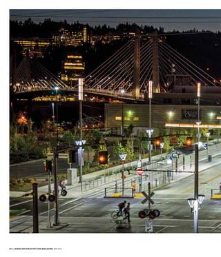
OMSI/SE WATER STATION
Portland’s newest bridge
and light rail line slip
between an opera house
and a museum on the
Willamette’s eastern bank.
PORTLAND LANDSCAPE ARCHITECTS BUILD COMMUNITY...
AND A NEW LIGHT RAIL LINE.
BY BETSY ANDERSON, ASSOCIATE ASLA/PHOTOGRAPHY BY BRUCE FORSTER
3. 94 / LANDSCAPE ARCHITECTURE MAGAZINE MAY 2016
N A HOT SEPTEMBER MORNING, Portland’s Central
Eastside shimmered with an unusual procession. Stand-
ing two, three, and four abreast, members of the Con-
federated Tribes of Grand Ronde emerged from the crowded
riverbank of this industrial district turned stylish hipster haunt.
In full regalia, tribal members stepped onto the city’s newest
bridge and began to cross the Willamette River, from east to
west. Joining them was a new light rail train—advancing at the
same rhythmic pace, its cars filled with state and local leaders
hovering above the river in a place no one had been before.
This was the grand opening of Portland’s latest stretch of light
rail, the MAX Orange Line. The inaugural crossing of the first
bridge built in this river city in four decades was broadcast
liberally by local television crews. Portlanders are an enthusi-
astic bunch when it comes to urban infrastructure—especially
transit—and the bridge, like any celebrity, has full Google cov-
erage. A quick search for the opening will result in numerous
video clips. As I am a Seattleite, this was my first glimpse of
the splashy new addition to our southern neighbor’s already
healthy and envied public transportation network. Dedicated
to transit, cyclists, and pedestrians, the bridge has received
considerable attention not for its many attributes but for
something it lacks—cars.
Called Tilikum Crossing, Bridge of the People, the lithe cable-
stayed structure honors the Chinookan belief that crossing a
river builds community. It is the linchpin of a 7.3-mile transit
alignment that conveys this idea from Portland’s city center to
a mosaic of southeast neighborhoods and suburbs, including
the town of Milwaukie in adjacent Clackamas County. Led by
landscape architects on all sides and in all phases of the project,
the Orange Line underscores the age-old Chinookan belief
that connectivity and community are mutually dependent.
In cultivating both, its designers propose a new paradigm for
transit in American cities.
O
4. LANDSCAPE ARCHITECTURE MAGAZINE MAY 2016 / 95
Tilikum means “people” in Chinook Wawa, a composite in-
ternational dialect that the region’s first inhabitants used to
communicate with other tribes, and later with fur traders,
explorers, and missionaries. It is a fitting word to describe
part of the Orange Line, a collaborative $1.49 billion effort
that engaged hundreds of landscape architects, architects, en-
gineers, artists, and contractors, filling the desks and drafting
tables of design and construction offices in the midst of the
2007–2009 recession. And these were just the consultants.
Working alongside were counterparts from TriMet, the local
public transit agency in charge of the new rail line (in transit
circles called simply “the alignment”), and staff representing
the jurisdictions through which the trains would pass.
The bridge, like the rest of the alignment, was 50 percent fund-
ed by the Federal Transit Administration’s New Starts program.
The remaining project costs of $745 million were covered by
a mixture of state and local sources. Noting my surprise that
federal transportation funding could support such placemak-
ing gestures, TriMet’s Sean Batty, ASLA, explained that it was
possible as long as the project could guarantee a favorable
cost-to-transit-benefit ratio. Batty served as the agency’s overall
conceptual design manager for the project. The Federal Transit
Administration (FTA) awards funding based on criteria that
measure a project’s mobility improvements, environmental
LEFT
Eight miles of new
or replaced bike lanes
trace the alignment.
RIGHT
At Oregon Health &
Science University’s
South Waterfront
Campus, the line
crosses a restored
industrial site, poised
for redevelopment.
5. 96 / LANDSCAPE ARCHITECTURE MAGAZINE MAY 2016
DOLLYHOLMES
N
MAX ORANGE LINE
RIGHT
The Tilikum Crossing
bridge knits the east
and westside stations
of the Orange Line
together.
OPPOSITE, TOP
The South Waterfront
station area layers
streetcar, bus, light
rail, car, pedestrian,
and bicycle traffic.
OPPOSITE, BOTTOM
Vegetated trackway
offers hardscape
relief for people and
stormwater alike.
/
6. LANDSCAPE ARCHITECTURE MAGAZINE MAY 2016 / 97
benefits, operating efficiencies, and cost-effectiveness against
a preinvestment baseline. Layering a shared transitway onto
Tilikum Crossing exponentially increased the project’s transit
benefit. In lieu of buses stuck in traffic on existing crossings, a
new light rail line, two unobstructed bus lines, and a city street-
car could now be factored into FTA calculations. The decision
to omit cars was also a cost-saving measure, one bolstered by
community members who didn’t want their neighborhoods
skewered by arterials and on-ramps. Instead, the 1,720-foot
bridge makes one community from two sides of the river,
elegantly joining the Oregon Health & Science University’s
South Waterfront Campus on the west bank with the Oregon
Museum of Science and Industry (OMSI) to the east.
Though functionally and economically indispensable, the
glamorous crossing is just one of many moving parts that con-
tributed to a transportation effort nearly heroic in its complex-
ity. I had a taste of the project’s intricacies in a recent meeting.
Seated around a conference table in TriMet’s Portland offices
were 11 landscape architects, including both public and private
practitioners, who had a hand in shaping the alignment’s loca-
tion, the design of its 10 stations, plantings and stormwater
mitigation, bicycle and pedestrian routes, and wayfinding. The
conversation quickly turned reflective—most in the room had
contributed to earlier light rail efforts, and some could trace
their involvement to the installation of the city’s first MAX—or
Metropolitan Area Express—line in 1986.
Only the third light rail line completed in the United States,
following San Diego’s (1981) and Buffalo’s (1984), Portland’s
Blue Line connected the city to its eastern suburb of Gresham
and was the direct result of community activism. After the
7. 98 / LANDSCAPE ARCHITECTURE MAGAZINE MAY 2016
defeat of the Mount Hood Freeway in 1974—which would
have eviscerated neighborhoods in the southeast section of
the city—Portland area residents pressed for light rail instead
of bus transit along the crowded corridor. TriMet (then the
Tri-County Metropolitan Transportation District of Oregon),
originally established to operate a regional bus system, sud-
denly found itself at the leading edge of light rail planning.
With the addition of each new section, the agency refined
its approach. Today Portland’s transit riders experience that
evolution: hopping from the Blue to the Red, Yellow, Green,
and Orange lines provides a strange sense of time travel. In
this way the Orange Line is a retrospective of Portland transit
projects, embodying what the agency has learned and revealing
the increasing clout of transit in this city.
“This not only represents a transect in the sense of physical
space, but it is also a transect of readiness—readiness for
things urban,” emphasizes TriMet’s Batty. A ride on the Orange
Line suggests that the transect was seamless, when in fact it
came together in two parts. To meet the project’s target 2015
completion, TriMet deployed two design teams, each working
from opposite ends of the alignment toward the Willamette
River, known as the “west segment” and “east segment” dur-
ing planning and construction. The urban design of each seg-
ment was managed by TriMet landscape architects Elizabeth
Higgins, Paige Schlupp, and Jeb Doran, ASLA, who oversaw
every facet and phase of the project. In addition to light rail,
this composite infrastructure included stormwater treatment,
ecosystem restoration, reforestation, alternative energy gen-
ABOVE
The project’s
286 bioswales treat
34 acres of runoff.
8. LANDSCAPE ARCHITECTURE MAGAZINE MAY 2016 / 99
N
WILLAMETTE RIVER
OLDWATERAVENUE
SE CARUTHERS STREET
NEW
WATERAVENUE
McLOUGHLINBOULEVARDVIADUCT
SE4THAVENUE
OMSI
PORTLAND
OPERA
McCOY MILLWORK
MAYER/REED,RIGHT
eration, 25 public art installations,
and miles of improved pedestrian
and bicycle access.
Spliced into downtown Portland,
the westernmost segment encom-
passes two stations and nearly a
mile of track, stretching from the
Yellow Line terminus, near Port-
land State University, to the foot
of the new bridge. Led by TriMet’s
Higgins, the west segment team
included Brian McCarter, FASLA,
of ZGF Architects, in charge of
urban design and station architecture; and Marianne Zarkin,
ASLA, whose firm, Marianne Zarkin Landscape Architects,
was responsible for the planting and irrigation design.
The eastern segment begins on the Willamette’s east bank, at
the Oregon Museum of Science and Industry, where it bends
south through a train track-laced swath of rail yards and former
warehouses. From here the Orange Line stitches itself, mostly
at grade, through a series of eight different neighborhoods be-
fore crossing the county line and culminating at a freshly built
park-and-ride garage in Oak Grove. TriMet assigned two urban
design leads, Schlupp and Doran, to wrangle the 6.1-mile seg-
ment, which includes eight stations and glides through a wildly
diverserangeoflandusesandcharacter.Froma110-acrerailyard
tosingle-familyhousestoagolfcourse,buriedstreams,
andaformerGoodwilloutletstore,thistransectexposes
both the products and tailings of more than a century
of urbanization.
“I call it a zipper,” explains Carol Mayer-Reed, FASLA,
“because it is zipping together two different kinds of
fabric: neighborhoods and the industrial core that
forms with the freight corridor.” Mayer-Reed’s mul-
tidisciplinary design studio, Mayer/Reed, steered the urban
design for this eastern stretch, “hand in glove,” as she puts it,
with Mike Faha, FASLA, of GreenWorks, PC, whose planting
design accentuates its liminal character.
The design of the stations was critical to the zipper concept:
“People aren’t used to walking through these neighborhoods,
these industrial nodes, because…why would they?” Mayer-Reed
asks. “All the development grows away from those areas, not
toward them. Yet when you put light rail stations there, you’re
asking people to go places they’ve never gone before.” This
is why landscape architecture is so important to transit, she
argues: “It really is a marketing effort. If you build a highway,
someone will always show up to drive on it. For light rail we
need to attract people on foot, and that’s much harder to do.”
The idea of creating a place where people might like to spend
time conflicts with the conventional notion of transit, which
calls for moving things along as quickly as possible.
OMSI/SE WATER STATION CONCEPT PLAN
LEGEND – Light Rail Components
EXISTING BUILDING
PROPOSED TRIMET BUILDING
HEAVY RAIL LINE
LIGHT RAIL LINE
SIGNALIZED INTERSECTION
STREET CAR
STATION PLATFORM AND SHELTER
PLANTING AREA
STORMWATER TREATMENT AREA
RAILING / FENCE
RETAINING WALL
BRIDGE ABUTMENT
STREET
STREET IMPROVEMENTS
SPECIAL PAVING
9. 100 / LANDSCAPE ARCHITECTURE MAGAZINE MAY 2016
Rather than a conduit, the Orange Line stations are places to
pause. Luminous columns tiled in handmade glass distinguish
each station. On a brisk January afternoon, I found myself
wanting to leap out at every stop just to compare, to touch
them. This was a first in my many years’ acquaintance with
public transportation. “These finer details create a sense of
place,” says TriMet’s Schlupp. “But they are transparent; they
let the community’s identity shine through.”
Schlupp’s comments echo a common refrain among design
team members: the notion of a station as a place. This philoso-
phy was forged through decades of transit experimentation,
says Bob Hastings, agency architect for TriMet. “What we’ve
learned over the years is the importance of including both ele-
ments of continuity and elements of distinction. Elements of
distinction are really about the human interaction and about
cultural identity—how you connect at a neighborhood level.”
Hastings provided design review for the entire rail line, man-
aged its rigorous sustainability program, and propelled the
project’s public involvement goals. These were inspired by the
Possibilities Project, what Hastings calls “a guerrilla exercise”
to engage future Orange Line neighbors in discussions about
design and community context.
Led by the artist Tad Savinar, the
grassroots effort also addressed
project and budget challenges, de-
velopment opportunities, and sus-
tainable practices. This outreach
took place in 2010 and early 2011,
after the Orange Line’s prelimi-
nary engineering phase but before
final design. TriMet’s landscape
architects credit the process with
galvanizing community design
aspirations and reducing the project’s environmental impacts.
“Without a doubt, we would not have had a net-zero park-
and-ride facility without the community pushing for it,” says
TriMet’s Doran, who managed the Milwaukie and Clackamas
County portion of the east segment. “The agency supported
solar infrastructure but was not ready to insist that we spend
the extra money for it.”
The SE Park Avenue Park & Ride, in Oak Grove, is a punctua-
tion mark for the line and for TriMet’s community engage-
ment process. By the time the garage design began, the agency
LEFT
The artist Bill Will’s
installation, Passage,
refers to a stream
that once flowed near
SE 17th Avenue.
OPPOSITE
The 38 rowboats and
wavelike plantings are
intended to be dynamic
when seen from a train
or bike.
10. LANDSCAPE ARCHITECTURE MAGAZINE MAY 2016 / 101
GREENWORKS,PC
had built a strong enough relationship with nearby residents
that it invited them to participate in design development and
reviews with designers GBD Architects and PLACE Studio.
The result is a structure whose low profile belies its 401 car
and 102 bike parking spaces. Cradled in a scoop of hillside
that collects and treats stormwater, the building is crisscrossed
with a scheme of angled gutters that highlight the descent of
the region’s frequent rain. The rest of the facade is fringed
with weathered steel spires that evoke the reeds that once
grew along the neighborhood’s long-buried creek. The overall
effect is a bit chaotic but will be tempered as the building is
claimed by its site: Moss and streaks of rust already inscribe
its ground line, and scrambling China blue vines and star
jasmine subdue the steel piles. In time the concrete and cars
will be cloaked in tall stands of Oregon white oak, Douglas
fir, and western red cedar, consistent with the neighborhood’s
desire to build a forest.
The Orange Line vibrates with this promise of growth, whether
of adjacent development opportunities or urban reforesta-
tion. “We considered the landscape aspect of this project in
ecological terms,” says GreenWorks’s Faha. He compares the
11. 102 / LANDSCAPE ARCHITECTURE MAGAZINE MAY 2016
N
ACCESS DRIVE
PEDESTRIAN
BRIDGE
UNION PACIFIC RAILROAD
JOHN
SON
CREEK
TACOMAOVERPASS
STEPS W/
HANDRAIL
RESTORATION
PLANTING
BRIDGE
CONCRETE
STAMPING
SE MCLOUGHLIN BOULEVARD (99E)
ACCESSDRIVE
ART LOCATION
EXISTING
BUS STOP
ART LOCATION
STATION
PEDLETON
WOOLEN
MILLS
SPRINGWATERCORRIDORTRAIL
MULTI-USE
TRAIL
PROPERTYLINE
BIKE
SHELTER
SUBSTATION
SIG. COM.
MAYER/REED
planting design to restoration of an urban clear-cut: “What are
the pioneer species needed in these industrialized areas to start
an early repair? We thought long-term about the climax forest
that was needed to stitch those neighborhoods and the light rail
line together over time.” In other places creeks were daylighted,
riparian verges restored, and at the SE Tacoma Street station
(once a Goodwill megastore), waiting transit riders can zigzag
along a graceful viewing platform to observe a recently unfet-
tered stretch of Johnson Creek.
Community participation is evident in investments like these,
as well as in the fastidious railing and paving details and big
luxurious plantings throughout. In addition, each of the 10
stations features a site-specific art installation, ranging in scope
and tactic from poetry stamped in concrete to enormous earth-
cast wheels to the great white bridge itself, whose nighttime
illumination keeps a finger on the pulse of the river, changing
color to reflect a shift in water temperature or flow.
Though representative, and perhaps aspirational, these ges-
tures are not always as transparent as TriMet claims. The
designers only hint that allowing a neighborhood’s character
to shine through might not be desirable in some areas. In
fact, several Orange Line stations strive to reflect “place” in
spots many would describe as placeless. This includes the
nondescript terrain of abandoned big box stores, or swollen
arterials—like SE 17th Avenue, which the project transformed
into a mile-long sculpture garden of 38 rusted steel rowboats,
commemorating another buried stream.
The stations sit less eas-
ily, however, in areas with a
more appreciable identity—
for instance in downtown
Milwaukie, or especially in
Portland’s historic Halprin
District, where the Orange
Line stops at Lincoln Street
and SW 3rd Avenue. The Lin-
coln Street station is positioned as if it were a new measure in
Lawrence Halprin’s Open Space Sequence, an inward-looking
1960s network of pedestrian corridors and parks—including
Lovejoy Plaza and Pettygrove Park—sheltered by high-rise
apartment and office buildings and towering shade trees.
Here cues to Halprin’s legacy were carefully preserved by
ZGF in original aggregate paving and the nodding profiles of
replacement streetlights. But in a district marked by interior
activity and discovery of what is hidden, the new train platform
feels painfully exposed. This is owing to the loss of dozens
of London plane trees, which once created a “forest” along
Lincoln Street, according to Marianne Zarkin. The widening
of the street for light rail and stormwater planters required the
removal of the trees, while the configuration of underground
utilities allowed the replacement of only a handful. “It was
very, very difficult,” says Zarkin. (TriMet states that it replaced
45 of the 48 trees taken from the right-of-way.)
In all, the Orange Line spelled the demise of more than 800
trees, although 3,325 new specimens were incorporated into
SE TACOMA/JOHNSON CREEK STATION CONCEPT PLAN
LEGEND – Light Rail Components
HEAVY RAIL & CROSSING
LIGHT RAIL LINE & CROSSING
EXISTING STREETS
STREET IMPROVEMENTS
EXISTING BUILDING
PROPOSED BUILDING
RETAINING WALL / SOUND WALL
SAFETY WALL
FENCE
RAILING
STATION PLATFORM/SHELTER
STORMWATER PLANTING
LANDSCAPE PLANTING
SEEDED AREA
PERVIOUS PAVING
12. LANDSCAPE ARCHITECTURE MAGAZINE MAY 2016 / 103
TOP LEFT
ESA Vigil–Agrimis led
an effort to restore
salmon habitat at
Johnson Creek.
TOP RIGHT
Lynn Basa’s
handcrafted glass
mosaic evokes salmon
returning to the creek.
INSET
Hundreds of new
bike spaces were
constructed, many
in covered open-air
shelters at the SE
Tacoma/Johnson Creek
station.
13. 104 / LANDSCAPE ARCHITECTURE MAGAZINE MAY 2016
LEFT
The Milwaukie station
negotiates a complex
crossing adjacent to
a freight rail line.
INSET
Though town leaders
pushed for a more
central location,
the Milwaukie station
seems to be spurring
increased activity
and development.
14. LANDSCAPE ARCHITECTURE MAGAZINE MAY 2016 / 105
SEMONROESTREET
SEWASHINGTONSTREET
SEADAMSSTREET
COVERED
BIKE RACK
SE 21ST AVENUE
SELAKEROAD
SEEDED
AREA
STATION PLATFORM
AND SHELTER
N
MAYER/REED,TOP
planting plans that introduced
more than nine acres of land-
scape to the urban corridor—
more often than not into gray-
field sites and along the back-
sides of wizened industry. These
humble working edges are
thickened with ample buffers of
young northwest conifers; un-
derfoot are bold swaths of plants
that read well from a train, in-
cluding grasses and leathery na-
tives like Oregon grape, salal,
and kinnikinnick. The roofs of
alignment bike facilities, signal
communications buildings, and
substations, and even a 200-foot section of track, are carpeted
with a jewel-toned tangle of Sedum.
This vegetated trackway may be a dubious consolation for
the Lincoln Street neighbors—the only station where it was
used—but its installation highlights the synergy that has come
to characterize Portland’s transit-building team. To mitigate the
nearly relentless concrete and absorb a modicum of stormwater,
TriMet’s designers persuaded the City of Portland, alignment
engineers, and the contractor, Stacy and Witbeck, to lay out the
one-inch-thick blanket of Sedum two years before the arrival of
the first trains. This allowed a sufficient testing and establish-
ment period: Although planted trackways have grown popular
in Europe, to date they’ve gained little traction in North Amer-
ica. A sympathetic regulatory environment made it all possible,
according to TriMet’s Hastings: “We had already tested ecoroofs
as an industry,” he explains. “We knew how they performed, we
knew the materials, and we had a city that understood that we
were essentially installing an ecoroof on the trackway.”
The designers around the table with me point out that such
consilience and willingness to experiment is the result of more
than 30 years of working hard, together. “We now have a shared
language with our team that transcends urban design and
landscape architecture and includes engineering,” says Jeramie
Shane, ASLA, who served as project manager for Mayer/Reed.
“It’s symbiotic.”
This expansive approach to infrastructure is visible in the 286
bioswales that trace the tracks, crammed with water-loving
Carex and Juncus, and in lovingly detailed sound and retain-
ing walls that integrate, rather than separate, the transit line
and its communities. But it may be most strongly conveyed
by the early assimilation of art into the rail line’s design and
construction. The light display on the bridge, otherwise pro-
hibitive, was incorporated into the design at the preliminary
engineering phase to ensure a cost-effective installation under
the structure’s design/build contract. TriMet’s robust public
art program serves as a model for public art in transit, largely
MILWAUKIE/MAIN STATION CONCEPT PLAN
LEGEND – Light Rail Components
HEAVY RAIL & CROSSING
LIGHT RAIL LINE & CROSSING
EXISTING STREETS
STREET IMPROVEMENTS
EXISTING BUILDING
PROPOSED BUILDING
RETAINING WALL
SAFETY WALL
FENCE
RAILING
STATION PLATFORM/SHELTER
STORMWATER PLANTING
LANDSCAPE PLANTING
SEEDED AREA
REINFORCED TURF
COBBLE PAVING
SPECIAL PAVING
15. 106 / LANDSCAPE ARCHITECTURE MAGAZINE MAY 2016
because it has artists on the payroll. “This is key to our suc-
cess,” stresses Mary Priester, the program’s manager. “Transit
is a unique environment, driven by engineering and practical
considerations that art programs are not necessarily subject to.”
Like connective tissue, the Orange Line is capable of flexing,
growing, and adapting over time. TriMet and consultant
designers never viewed the alignment as an inert corridor,
describing it instead as a living entity that both initiates and
responds to change. “Are we trying to solve a transportation
problem?” asks TriMet’s Batty. “No, we’re trying to solve an
urban design problem, which we’re defining as landscape
architects: We’re trying to create positive human habitat.
When you stop seeing these projects as infrastructure and
start seeing them as our habitat, you have to start seeing the
concept of succession in them. And that allows you to see how
malleable the city is.
“We didn’t solve an engineering problem and then tell the
public that we could only solve an engineering problem,” Batty
says. “We solved for the urban design problem and budgeted
for that,” he continues, to explain in part the project’s total bill,
which came in more than $40 million under budget. “People
want good places, walkable places, good urban design. They
16. LANDSCAPE ARCHITECTURE MAGAZINE MAY 2016 / 107
OPPOSITE
Railings feature
Milwaukie’s symbolic
dogwood flower and
aim to impart a
small-town feeling.
RIGHT
A granite streambed
was carved by Brian
Goldbloom to convey
stormwater.
INSET
Stormwater planters
edge a future
development site at
the Milwaukie station.
17. 108 / LANDSCAPE ARCHITECTURE MAGAZINE MAY 2016
want infrastructure that is frugal and serves its purpose, but
that has some dedication to aesthetic issues, including scale,
appropriateness, and context—both historic and looking for-
ward. They want projects that facilitate the future.”
“We have lived in this community for a long time,” adds Mayer-
Reed, “and we see the results of every move we make.”
BETSY ANDERSON, ASSOCIATE ASLA, IS A RECENT MLA GRADUATE OFTHE UNI-
VERSITY OF WASHINGTON. SHE IS CURRENTLY BASED IN SEATTLE, WHERE SHE
WORKS FOR THE NATIONAL PARK SERVICE.
Project Credits
OWNER TRIMET, PORTLAND, OREGON. EAST SIDE: 8 STA-
TIONS PRIME CONSULTANT DAVID EVANS AND ASSOCI-
ATES, PORTLAND, OREGON. URBAN DESIGN TASK LEAD
MAYER/REED, INC., PORTLAND, OREGON. PLANTING AND
IRRIGATIONDESIGN;STORMWATERFACILITIESANDGREEN
ROOFSGREENWORKS,PC,PORTLAND,OREGON.FLOODPLAIN
RESTORATION DESIGN AT SE TACOMA/JOHNSON CREEK
STATION AND WATERWAY CROSSINGS ESA VIGIL-AGRIMIS,
PORTLAND,OREGON.STATIONARCHITECTUREANDKELLOGG
BRIDGE DESIGN WATERLEAF ARCHITECTURE, PORTLAND,
OREGON. SE PARK AVENUE PARK & RIDE DESIGN/BUILD
TEAMSKANSKABUILDINGUSA,NEWYORK;GBDARCHITECTS,
PORTLAND, OREGON; PLACE STUDIO, PORTLAND, OREGON.
WEST SIDE: 2 STATIONS PRIME CONSULTANT CH2M, PORT-
LAND, OREGON. URBAN DESIGN TASK LEAD AND STATION
ARCHITECTURE; STREETSCAPE, GREEN INFRASTRUCTURE,
MULTIMODAL DESIGN, HARBOR DRIVE BRIDGE ARCHI-
TECTURE ZGF ARCHITECTS LLP, PORTLAND, OREGON. AC-
TIVE TRANSPORTATION DESIGN ALTA PLANNING + DESIGN,
PORTLAND, OREGON. PLANTING AND IRRIGATION DESIGN
MARIANNE ZARKIN LANDSCAPE ARCHITECTS, PORTLAND,
OREGON. COLLABORATEDWITH ZGF ON STATIONARCHITECTURE LEEKAARCHI-
TECTURE & PLANNING, PORTLAND, OREGON. OTHER KEY CONSULTANTS STATION
PAVING, PLAZAS, CUSTOM RAILINGS, FURNISHINGS AND SHELTERS DESIGN,
BICYCLEANDPEDESTRIANFACILITIESDESIGN;SIGNAGE/WAYFINDINGDESIGN;
JOHNSONCREEKANDHALPRINDISTRICTINTERPRETIVEPANELSMAYER/REED,
INC., PORTLAND, OREGON. SYSTEMS BUILDING DESIGN HENNEBERY EDDY
ARCHITECTS, INC., PORTLAND, OREGON. GREEN ROOF DESIGN FOR SYSTEMS
BUILDINGS LANGO HANSEN LANDSCAPE ARCHITECTS, PORTLAND, OREGON.
SUSTAINABILITY STRATEGIES VIA ARCHITECTURE, SEATTLE. GENERAL CON-
TRACTOR STACY AND WITBECK, INC., PORTLAND, OREGON. TILIKUM CROSSING
BRIDGE DESIGN DONALD MACDONALDARCHITECTS, SAN FRANCISCO. CONCEP-
TUAL AND PRELIMINARY ENGINEERING AND OWNER’S TECHNICAL RESOURCE
HNTB, PORTLAND, OREGON. FINAL DESIGN AND ENGINEER OF RECORD T. Y. LIN
INTERNATIONAL GROUP, SAN FRANCISCO. CONTRACTOR KIEWIT INFRASTRUC-
TURE WEST COMPANY, OLYMPIA, WASHINGTON.
LEFT
The SE Park Avenue
Park & Ride varies
the terrain of a major
regional arterial.
OPPOSITE
The end of the line
came with a much-
needed gathering
space for the Oak
Grove neighborhood.