OGRS2016_ok
•
1 like•61 views

This multi-level agent-based model was created to assess forest fire management in southern Switzerland. It simulates the daily movements of individuals to investigate the impact on fire occurrences. The model employs an open-source platform called GAMA to build spatially explicit agent-based simulations allowing multiple levels of modeling. Preliminary results show the model can perform a visual correlation between fire ignitions and human presence by tracking people moving on the road network and capturing population distribution over time. Investigation of firefighters' response efficiency is still ongoing.
Recommended

Recommended
More Related Content
Similar to OGRS2016_ok
Similar to OGRS2016_ok (20)
More from AnnalisaMinelli
OGRS2016_ok
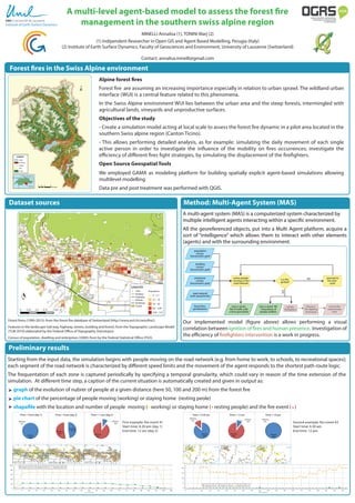
- 1. A multi-level agent-based model to assess the forest fire management in the southern swiss alpine region MINELLI Annalisa (1), TONINI Marj (2) (1) Indipendent Researcher in Open GIS and Agent Based Modelling, Perugia (Italy) (2) Institute of Earth Surface Dynamics, Faculty of Geosciences and Environment, University of Lausanne (Switzerland) Contact: annalisa.minelli@gmail.com Alpine forest fires Forest fire are assuming an increasing importance especially in relation to urban sprawl. The wildland urban interface (WUI) is a central feature related to this phenomena. In the Swiss Alpine environment WUI lies between the urban area and the steep forests, intermingled with agricultural lands, vineyards and unproductive surfaces. Objectives of the study - Create a simulation model acting at local scale to assess the forest fire dynamic in a pilot area located in the southern Swiss alpine region (Canton Ticino). - This allows performing detailed analysis, as for example: simulating the daily movement of each single active person in order to investigate the influence of the mobility on fires occurrences; investigate the efficiency of different fires fight strategies, by simulating the displacement of the firefighters. Open Source Geospatial Tools We employed GAMA as modeling platform for building spatially explicit agent-based simulations allowing multilevel modelling. Data pre and post treatment was performed with QGIS. Forest fires in the Swiss Alpine environment Institute of Earth Surface Dynamics Preliminary results Method: Multi-Agent System (MAS) A multi-agent system (MAS) is a computerized system characterized by multiple intelligent agents interacting within a specific environment. All the georeferenced objects, put into a Multi Agent platform, acquire a sort of “intelligence” which allows them to interact with other elements (agents) and with the surrounding environment. A multi-agent system (MAS) is a computerized system characterized by multiple intelligent agents interacting within a specific environment. All the georeferenced objects, put into a Multi Agent platform, acquire a sort of “intelligence” which allows them to interact with other elements (agents) and with the surrounding environment. population census (hectometric grid) dwelling census (hectometric grid) enterprise census (hectometric grid) active people moving on the road network road network (with speed limits) is a fire ignited? call the firefighters save a vector file of positions of people andfires record the intervention time save a vector file of traffic with a time granularity choose a fire fighting technique YES proceed to the next cycle NO forest fires geodatabase Our implemented model (figure above) allows performing a visual correlation between ignition of fires and human presence. Investigation of the efficiency of firefighters intervention is a work in progress. Starting from the input data, the simulation begins with people moving on the road network (e.g. from home to work, to schools, to recreational spaces); each segment of the road network is characterized by different speed limits and the movement of the agent responds to the shortest path route logic. The frequentation of each zone is captured periodically by specifying a temporal granularity, which could vary in reason of the time extension of the simulation. At different time step, a caption of the current situation is automatically created and given in output as: graph of the evolution of nubrer of people at a given distance (here 50, 100 and 200 m) from the forest fire pie chart of the percentage of people moving (working) or staying home (resting peole) shapefile with the location and number of people moving ( working) or staying home ( resting people) and the fire event ( ) Dataset sources Forest firess (1990-2015): from the forest fire database of Switzerland (http://www.wsl.ch/swissfire/). Features in the landscape (rail way, highway, streets, building and forest): from the Topographic Landscape Model (TLM 2010) elaborated by the Federal Office of Topography (Swisstopo). Census of population, dwelling and enterprises (2000): from by the Federal Statistical Office (FSO). Resting 10% Working 90% Time = 12 am Resting 100% Working 0% Time = 10 pm Resting 86% Working 14% Time = 6.30 am Resting 47%Working 53% Time = 9 am (day 2) Resting 10% Working 90% Time = 1 pm (day 2) Resting 100% Working 0% Time = 9 pm (day 1) First example: fire event #1 Start time: 8.30 pm (day 1) End time: 12 am (day 2) Second example: fire event #2 Start time: 6.30 am End time: 12 pm Time (cycle #) Time (cycle #)