1. Aim: What is a topographic map?
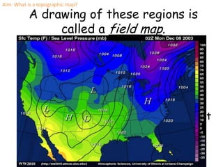
A drawing of these regions is
called a field map.
Isolines connect points of equal value.
Isolines of temperature are called
Isotherms.
Isolines of equal air pressure are called
Isobars (the Bar is a metric measurement
of pressure)
2. Isolines of equal height (elevation) are called
Contour Lines
A Contour line is a type of Isoline that
shows an area’s surface features.
Contour Interval = difference of elevation
between contour lines.
Aim: What is a topographic map?
3. A field is a region with Isolines are lines that are
drawn on a field map.
a measurable quantity They connect points that
at every location. have the same value.
Aim: What is a topographic map?
5. • Contour lines are isolines that are drawn on an elevation map.
• These lines connect all points with the same elevation.
Contour Interval:
The difference
between elevation
from line to line.
Aim: What is a topographic map?
8. Aim: What is a topographic map?
The smallest circle is the highest point on that hill.
Look at the arrow. What elevation is the last circle?
• 220m
And what elevation would the dot be?
• 239m. It can’t be 240 because there is no smaller circle.
9. Topographic Depressions
A circle with small dashes show a depression.
A depression = a hole.
Aim: What is a topographic map?
10. Which one is
the proper
profile?
Aim: What is a topographic map?
11. Topographic Mapping
Vocabulary
• Elevation-
– A points height above sea level (ex: 40 meters
above sea level)
• Contour Line-
– A line on a map joining points of equal height
above or below sea level.
• Contour Interval-
– The difference in altitude represented by the
space between two contour lines on a map.
Aim: What is a topographic map?
12. Key Concepts
• Contour lines never cross!
– All points on a contour line are one elevation.
• The spacing of the lines depend on steepness.
– Close lines = steep slope
• Contour lines that cross a valley or stream are “V”
shaped. The “V” points UPSTREAM.
• Closed circles show the top of hills/mountains, and
depressions. Depressions have hash marks.
Aim: What is a topographic map?
13. H.W
• Do the questions on pg. 27.
• Look at the map on pg. 29. Write three things
that you can tell me about this map. Use
what you learned today!
14. You have to get to the top of Mt.
Ginger to set a signal fire for your
rescue. Which way is easiest?
Notice:
1. Closer lines mean
fast changes.
2. “V’s” in lines
Point upstream
(toward the source)
for Streams and
rivers