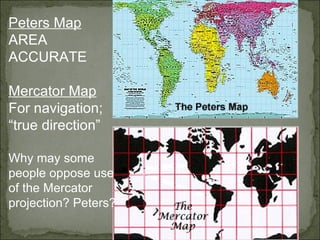
Arno Peters, German map maker, historian and journalist, developed an equal area map projection in the early 1970’s in order to counter the commonly used "Eurocentric" Mercator map projection. He stated, "In our epoch, relatively young nations of the world have cast off the colonial dependencies and now fight for equal rights. It seems important to me that developed nations are no longer at the center of the world, but are plotted according to their true size." He points out that on the Mercator map Europe’s 3.8 million square miles are made to appear larger than South America’s 6.9 million square miles. Peters initially wrote a controversial world history text and found that "the quest for the causes of arrogance and xenophobia has led me repeatedly back to the global map as being primarily responsible for forming people’s impression of the world." It is important to note that the Mercator projection is rarely used today except for the purpose it was originally designed for - navigation. Of course, many Mercator maps can still be found in use by graphic designers, in older classroom materials, and as inexpensive wall maps. Cartographers have criticized the Peters map in part due to its distortion of the shapes of continents - one cartographer went so far as to describe the effect as being "the resulting land masses are somewhat reminiscent of wet, ragged, long winter underwear hung out to dry on the Arctic Circle." While each continent is reflected accurately in terms of area proportion, the overall effect of the maps is not a realistic portrayal of the earth. Cartographers argue that numerous projections developed since the Mercator projection (such as the Robinson and the Goode) succeed in achieving a more realistic image without a Europe centered focus. In fact, equal area projections had existed since 1772, but the press, the United Nations, the World Council of Churches, and the National Council of Churches heralded the Peters map as a way for the "Third World" to break away from colonial constructs. Thus, timing was everything; many nations of the world had just achieved independence from colonial powers within the previous decade. Peters, as an accomplished journalist, knew the art of generating publicity. There ensued an on-going debate over the use of this map between cartographers on the one hand, and people who believed the map would change people’s perceptions about the Third World on the other.
As I sat down at breakfast this morning, I poured myself a bowl of cocoa puffs and thought of what my geography teacher had talked about in class yesterday. Much of the chocolate we eat is from Africa. [where? - For example, Ghana and Nigeria] While eating, I picked up the newspaper and discovered that the President will be traveling to France, China and Africa [where?] in upcoming months. My father drove me to school and he, as always, listened to the news on the radio. I heard that in the country of Africa [where?] famine and ethnic conflict continue to be a major concern. In geography class today we had an African guest speaker. I asked him why it was always so hot in Africa [where? - Remember this may be true of some locales at some times of the year but there is also much cold weather in highland areas (snow on Mt. Kilimanjaro, as well as ice in winter months on the high plateaus of Southern Africa)]. One of my friends said that when her family traveled to Africa [where?], her mother had worried about tropical diseases in Africa [where? - Perhaps some equatorial areas but not everywhere]. Later that day, in science class we talked about nuclear energy and learned that Africa [Madagascar, South Africa, Zaire] has large deposits of uranium used in creating energy. After school, I relaxed in front of the television watching old movies on Nickelodeon and drinking a Coke. I remembered my geography teacher having said that the cola flavor comes from kola nut trees grown in Africa [numerous West African countries]. I watched an old Tarzan movie and wondered about the African [where?] jungle [the term "rainforest" is more accurate, and rainforest is only found along the coast of West Africa, in parts of Madagascar, and inland along the Zaire river basin]. I also thought about what our guest speaker had said today, "Africa is so diverse that it is hard to make generalizations about this continent."
2nd Largest Continent: Africa is the second largest continent in the world. (Asia is the largest.) Africa is three times the size of the continental United States. Measuring north to south, Africa is 5,200 miles long! At its widest point, Africa is nearly as wide as it is long. Rivers: Africa has five huge river systems. The big three, in order of size, are the Nile, the Congo, and the Niger. Oceans: In spite of its size, Africa has few natural harbors. If you wanted to visit Africa by boat, you would have to hunt for a safe place to land. Without a safe harbor, powerful ocean current would slam your boat into the rocks along the coastline. The Atlantic Ocean borders Africa to the west, the Indian Ocean borders Africa to the east, and the Mediterranean borders Africa to the north. The Atlantic and Indian Oceans meet to border Africa to the south. Africa is nearly surrounded by water. Landforms: Africa has rainforests, grasslands, and is home to the largest desert in the world, the Sahara. Africa does have a few mountain ranges, like the Atlas Mountains in the north. These are good size mountains, but they would appear to be hills if you put them next to the Alps or the Himalayas. Africa does not have a huge mountain range. Prime Meridian: The prime meridian, which is the imaginary line that separates the world into Eastern and Western Hemispheres runs vertically through Africa. Another imaginary line runs horizontally though Africa – the Equator.