Kodo Millet PPT made by Ghanshyam bairwa college of Agriculture kumher bhara...
Geography 2
1. Question 1 (Geography)
The 1890 U.S. Census led some people to conclude that there was no longer a frontier line in the West. Early in the
20th century, President Theodore Roosevelt advocated the conservation of the nation’s natural resources.
These events signaled a change in how people perceived
A. farmland.
B. urban areas.
C. wilderness areas.
D. centers of industry and technology.
Question 2 (Geography)
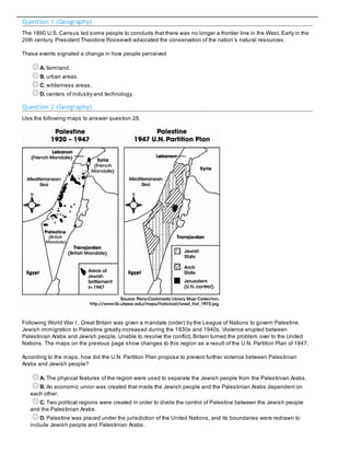
Use the following maps to answer question 28.
Following World War I , Great Britain was given a mandate (order) by the League of Nations to govern Palestine.
Jewish immigration to Palestine greatly increased during the 1930s and 1940s. Violence erupted between
Palestinian Arabs and Jewish people. Unable to resolve the conflict, Britain turned the problem over to the United
Nations. The maps on the previous page show changes to this region as a result of the U.N. Partition Plan of 1947.
According to the maps, how did the U.N. Partition Plan propose to prevent further violence between Palestinian
Arabs and Jewish people?
A. The physical features of the region were used to separate the Jewish people from the Palestinian Arabs.
B. An economic union was created that made the Jewish people and the Palestinian Arabs dependent on
each other.
C. Two political regions were created in order to divide the control of Palestine between the Jewish people
and the Palestinian Arabs.
D. Palestine was placed under the jurisdiction of the United Nations, and its boundaries were redrawn to
include Jewish people and Palestinian Arabs.
2. Question 3 (Geography)
Consider the following changes that occurred in the United States in the late 19th century:
improvements in agricultural production;
increases in immigration from Europe;
advancements in networks of railroad and streetcar lines;
These changes led to the
A. rapid growth of urban areas.
B. acquisition of overseas territories.
C. elimination of large suburbs around many cities.
D. movement of people from the urban to the rural areas.
Question 4 (Geography)
The European Union’s objectives include reducing tariffs, promoting a single market, and creating a common
currency.
Based on these objectives, what type of world region does the European Union primarily represent?
A. cultural
B. physical
C. political
D. economic
Question 5 (Geography)
One cause of suburbanization in the United States during the 1920s was increased
A. overcrowding in cities.
B. economic opportunities in rural towns.
C. emigration from the United States.
D. economic reliance upon agriculture.
Question 6 (Geography)
In the late 19th and early 20th centuries, improvements in steel technology allowed architects to design buildings
taller than had previously been possible. As a result, skyscrapers began to be built in cities such as New York and
Chicago.
What was the result of this new technology on population patterns in the United States in the first half of the 20th
century?
A. decreased growth of suburban areas
B. migration from the West to the Midwest
C. greater population density in urban areas
D. increased migration from urban to rural areas
Question 7 (Geography)
3. In 1959, rebel forces led by Fidel Castro overthrew the government of Cuba. Castro’s communist dictatorship seized
privately owned farms and factories. People who spoke out against the government were imprisoned. From the
1960s through the 1980s, many people fled from Cuba to the United States.
Based on these conditions, the reasons for this migration were
A. health concerns.
B. economic concerns.
C. environmental concerns.
D. racial concerns.
Question 8 (Geography)
In 1950, New York City was the only city in the world with a population of more than ten million people. By 2000, there
were nineteen cities with populations of over ten million people. One reason for this increase in urbanization was
A. a decrease in birthrates around the world.
B. the spread of industrialization around the world.
C. an increase in air pollution in industrialized areas.
D. the collapse of the Soviet Union and the end of the Cold War.
Question 9 (Geography)
In recent decades, a number of states have passed laws designed to protect wetlands such as marshes and
swamps. These laws make it difficult for developers to begin new construction on wetlands.
This trend was motivated by
A. a decrease in the economic value of wetlands.
B. an increase in the geographical area covered by wetlands.
C. a decrease in the number of environmental threats to wetlands.
D. an increased awareness of the environmental importance of wetlands.
Question 10 (Geography)
In the years following World War II, the countries of communist Eastern Europe were often referred to as being
“behind the iron curtain.”
These countries were perceived as a single region based on
A. a common cultural heritage.
B. unique physical features.
C. economic and political characteristics.
D. widespread immigration from other regions.
Question 11 (Geography)
Which factor contributed to increased migration of people among regions of the United States in the second half of
the 20th century?
A. new restrictions on immigration from Asia
B. increases in the number of small family farms
C. the construction of the Interstate Highway system
D. increased immigration from Northern and Western Europe
Question 12 (Geography)
The North American Free Trade Agreement (NAFTA) is a treaty designed to remove tariffs and other trade barriers
between Canada, Mexico and the United States. This helped establish an economic region among those nations
4. because
A. participants enlarged their dependence on domestic markets.
B. participants terminated trade relationships with other regions.
C. participants imposed tariffs on goods imported from other countries.
D. trade among participants increased, making their economies more interdependent.
Question 13 (Geography)
The growth of suburbs has caused the economic value of land around many U.S. cities to increase. One result of
this increase in land value has been a decrease in
A. U.S. food production for export.
B. the availability of agricultural labor in urban regions.
C. the construction of roads, water lines and sewer lines.
D. the amount of land available for farming.
Question 14 (Geography)
Use the following graph to answer question 3.
The economic development of the United States between 1870 and 1950 helped produce the results shown in the
graph above. The trend shown in the graph is associated with
A. increased urbanization.
B. decreased immigration.
C. advances in communication.
D. reduced population growth.
Question 15 (Geography)
People from the countries of Scandinavia—Finland, Denmark, Norway and Sweden—immigrated to the United
States mainly between the Civil War and World War I. In general, they settled in the American Midwest. Their reasons
for leaving their homelands included overpopulation, poor farm production and dissatisfaction with their
governments.
Based on your knowledge of immigration patterns to the United States, identify two factors that attracted immigrants
such as these to the United States.
Write your answer in the Answer Document. (2 points)
5. Question 16 (Geography)
In 1960, 8.9 million acres of land in northeast Alaska were designated as the Arctic National Wildlife Range. In 1980,
legislation doubled the size of the Range and renamed it the Arctic National Wildlife Refuge (ANWR). In recent years,
attempts have been made to open part of the ANWR to oil exploration. The reason for this proposal is that the
A. need for oil has decreased.
B. population of the region has increased.
C. environmental features of the region have changed.
D. perceived economic value of the region has changed.