Building Open Geospatial Science Network, Suchith Anand, University of Nottingham
•Download as PPT, PDF•
2 likes•674 views

Conference Opening Science to Meet Future Challenges, Warsaw, March 11, 2014, organized by Interdisciplinary Centre for Mathematical and Computational Modelling, University of Warsaw.

Recommended
Recommended
More Related Content
What's hot
What's hot (20)
Similar to Building Open Geospatial Science Network, Suchith Anand, University of Nottingham
Similar to Building Open Geospatial Science Network, Suchith Anand, University of Nottingham (20)
More from Platforma Otwartej Nauki
More from Platforma Otwartej Nauki (20)
Recently uploaded
Recently uploaded (20)
Building Open Geospatial Science Network, Suchith Anand, University of Nottingham
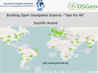
- 1. Building Open Geospatial Science -“Geo for All” Suchith Anand http://www.geoforall.org
- 2. Mission Making Geospatial education accessible to all “Geo for All”
- 3. Why? Very few universities/educational institutions in developing/poor countries currently are able to teach Geospatial Science courses High cost of software Lack of skilled staff Lack of freely available training materials
- 4. ICA- OSGeo MoU Prof. Georg Gartner (ICA President) and Arnulf Christl (OSGeo President) shake hands after signing the MoU at Intergeo 2011 in Germany (Sep 2011)
- 5. ICA is the world authoritative body for cartography and Geographic Information Science
- 6. Open Source Geospatial Foundation (OSGeo)
- 7. OS Geo Product development statistics 2008 Open Source Geospatial Foundation (OSGeo) established in Feb 2006 OSGeo is the leader of Open Source Geospatial and high impact community
- 8. Why - Social Responsibility Making resources including software and data openly available offers an opportunity for knowledge to be shared widely so as to increase learning opportunities. Example – Collaborating with educational initiatives like gvSIG Batoví For details contact: Sergio Acosta y Lara sacosta@dntopografia.gub.uy Alvaro Anguix aanguix@gvsig.com
- 9. For details contact: Sergio Acosta y Lara sacosta@dntopografia.gub.uy Alvaro Anguix aanguix@gvsig.com gvSIG Batoví: an educational resource for Plan Ceibal https://gvsig.org/web/home/projects/gvsigeduca
- 10. Aims of ICA-OSGeo Labs Initiative • Establishing research and training opportunities in open source GIS • Build teaching and research infrastructure worldwide • Provide worldwide learning platform
- 11. “Geo for All” Education Initiative Distribution ICA-OSGeo labs established in Europe Image : OSGeoREL @NCSU (6 months back) ICA-OSGeo MoU in Sep 2011 70 labs established worldwide as of today North America – 13 labs Europe – 25 labs South America – 9 labs Africa – 4 labs Asia – 15 labs Australia - 1 lab Will be establishing over 100 labs in universities worldwide by Sep 2014
- 12. Why having a framework for Open Geospatial Science important for the future? Strategic level Research Teaching Attracting research funding /sustainability Social Responsibility
- 13. Open Geospatial Research Geospatial Standards (for ex. OGC spec.) Maturity of open source software (for ex. OSGeo stack) Open Data Ability for showing the operation of general laws is fundamental for scientific research Open GIS is key for innovation in GIS
- 14. Aim 1 Establishing open source GIS research and training opportunities
- 17. Open Geospatial Labs are being established worldwide to scale up research and teaching in this theme globally (ICA-OSGeo MoU) University of Pretoria, South Africa Aim 2 – Scale up research and teaching
- 18. Poland strongly represented in “Geo for All”
- 19. Free webinars
- 20. Example of an excellent Initiative led by Prof. Maria Brovelli and colleagues http://eurochallenge.como.polimi.it
- 23. Aim 3 - Providing Global learning platform and training opportunities
- 24. Open Science 2014 sessions planned at OSGIS 2014. We look forward to welcoming you to Nottingham.
- 26. http://www.geoforall.org Making Geospatial education accessible to all