SlideShare a Scribd company logo
1 of 1
Download to read offline
Enhancing and Educating with the WxSat Mobile App
Kyle A. Nelson1 and Margaret Mooney2
Cooperative Institute for Meteorological Satellite Studies (CIMSS), University of Wisconsin-Madison
Contact Information:
1wxkylenelson@gmail.com 2margaret.mooney@ssec.wisc.edu
I. Vision and Proposal
With ease of access to satellite imagery online and its display increasingly often in local and
national TV weather segments, interest is growing. If we are to become a more Weather Ready
Nation, it is critical to enhance the weather literacy of the general public, weather enthusiasts
and decision-makers worldwide who view satellite and other earth data products and use them
to make informed decisions.
For this FUNding Friday project, I set out to achieve two goals:
1.  to enhance the free WxSat mobile app to add selectable IR and WV color table
enhancements in addition to the black and white Visible, IR and WV imagery.
2.  Add a tutorial for Visible, IR and WV imagery with static annotated images to highlight
examples of features often seen in these imagery types and to aid the user in better
interpreting what the image is showing and how it relates to them at ground level.
III. Web Map Service and RealEarth
V. WxSat: Now More Powerful Than Ever Before
II. WxSat App: A Starting Point
VI. Future Collaborations for SSEC RealEarthIV. Product Information Pages – An Educational Component
VIII. Release Information
•  Expect upgraded WxSat release in Early 2015; The upgrade will be FREE!
•  Current WxSat users will receive an upgrade notification in their App Store
What is WMS?
•  OGC-compliant method for serving geo-referenced images & data to different client types
•  OGC = Open Geospatial Consortium
What is RealEarth?
•  A distributable framework for ingesting and managing geospatial data for serving to a
variety of clients:
•  Tile services: Google Maps, iOS App, Android App
•  GIS software; KML (Google Earth); THREDDS (data discovery)
•  Provides an environment to scientists and researchers to upload data:
geolocated images, products, and observations
•  Facilitates research by providing the ability to animate through time, layer time-matched
data, and probe interactively.
•  Enables visualization of data via web browsers, GIS tools, and mobile device apps
•  Helps outreach activities by making it easy for anyone to view the products in a
webpage or on phones and tablets.
•  Shares results and displays through unique URLs, Facebook, Twitter, etc. to allow other
researchers and the public to view these products in near real-time
Technical Overview
•  Ingest: Many formats (PROJ4); Simple HTTP upload
•  Management: Metadata; Arbitrary product size
•  Serving:
•  Tiles: Rectangles of partial images
•  Shapes: Plots of data values
•  Data probes: Pop up windows of additional information at specific location
•  Architecture: 8GB Linux Virtual Machine using HTTP for all access
•  Proxy to Other VMs
•  Proxy collects and combines information (tiles, shapes, metadata, etc) from the
appropriate host and returns the result to the client
•  The curation of 25 mobile-friendly product information web pages establishes the WxSat
app and reaffirms SSEC RealEarth as educational earth science data viewers.
•  The information pages provide users with a qualitative explanation of the product being
viewed, using plain language so that readers will not be bombarded by jargon and
acronyms commonly used in the atmospheric sciences
•  Pages are accessed via the “I” or information icon in RealEarth and WxSat
•  A pop-up info window (RealEarth) or an external web page (WxSat) will display the info
• GOES-R derived products
• Wildfire detection
• Lightning detection
• Cloud properties
• Clear sky mask
• Rain rate
• Etc… (http://www.goes-r.gov/products/baseline.html)
• DOT
• Winter road conditions
across state lines
• Pilot Training System
• Flight basemaps
• NOTAMs, SIGMETS, etc.
• Custom App Versions
• Easier Product Navigation
• Narrow Focus
Special Thanks:
•  Margaret Mooney for her guidance and mentorship on this project
•  ESIP Education Committee for a phenominal year as a Student Fellow
•  FUNding Friday awards committee and donators for project funding
•  Dave Parker, SSEC Primary Architect and Programmer, for his coding expertise
•  Tommy Jasmin, SSEC Systems Developer, for his programming expertise
•  Erik Gould for design and curation of product information pages
VII. Access SSEC RealEarth and Download WxSat now!
SSEC RealEarth
(http://re.ssec.wisc.edu)
WxSat – Apple iOS WxSat - Android
Cleaner display
Custom layering Create favorites Explore!
More configurable More products
•  Available for iOS and Android
•  Features
•  Global Visible, Infrared and Water Vapor images
•  6-hour imagery loops
•  Leverages RealEarth Map Service
•  Expandable
By expanding the available datasets beyond the original Visible, Infrared and Water Vapor
satellite imagery, WxSat becomes a powerful and robust real-time weather analysis and case
study tool for the public, scientists and decision makers.

More Related Content

Viewers also liked

HTML5 with examples
HTML5 with examplesHTML5 with examples
HTML5 with examplesgopivthmk
 
Connect front end to back end using SignalR and Messaging
Connect front end to back end using SignalR and MessagingConnect front end to back end using SignalR and Messaging
Connect front end to back end using SignalR and MessagingParticular Software
 
App idea powerpoint
App idea powerpointApp idea powerpoint
App idea powerpointChris Bailey
 
Creating an app for iPad, application development of an interactive picture book
Creating an app for iPad, application development of an interactive picture bookCreating an app for iPad, application development of an interactive picture book
Creating an app for iPad, application development of an interactive picture bookRian Visser
 
Creating an App for Your Event or Association
Creating an App for Your Event or AssociationCreating an App for Your Event or Association
Creating an App for Your Event or AssociationBen Martin
 
Creating the first app with android studio
Creating the first app with android studioCreating the first app with android studio
Creating the first app with android studioParinita03
 
Android Application Development
Android Application DevelopmentAndroid Application Development
Android Application DevelopmentBenny Skogberg
 
Awesome Tools & Apps for Student Projects
Awesome Tools & Apps for Student ProjectsAwesome Tools & Apps for Student Projects
Awesome Tools & Apps for Student ProjectsShelly Sanchez Terrell
 

Viewers also liked (11)

Hanni brown proposal
Hanni brown proposal Hanni brown proposal
Hanni brown proposal
 
Mobile App Idea
Mobile App IdeaMobile App Idea
Mobile App Idea
 
HTML5 with examples
HTML5 with examplesHTML5 with examples
HTML5 with examples
 
Connect front end to back end using SignalR and Messaging
Connect front end to back end using SignalR and MessagingConnect front end to back end using SignalR and Messaging
Connect front end to back end using SignalR and Messaging
 
App idea powerpoint
App idea powerpointApp idea powerpoint
App idea powerpoint
 
Creating an app for iPad, application development of an interactive picture book
Creating an app for iPad, application development of an interactive picture bookCreating an app for iPad, application development of an interactive picture book
Creating an app for iPad, application development of an interactive picture book
 
Creating an App for Your Event or Association
Creating an App for Your Event or AssociationCreating an App for Your Event or Association
Creating an App for Your Event or Association
 
Creating the first app with android studio
Creating the first app with android studioCreating the first app with android studio
Creating the first app with android studio
 
Android Application Development
Android Application DevelopmentAndroid Application Development
Android Application Development
 
Awesome Tools & Apps for Student Projects
Awesome Tools & Apps for Student ProjectsAwesome Tools & Apps for Student Projects
Awesome Tools & Apps for Student Projects
 
Android ppt
Android pptAndroid ppt
Android ppt
 

Similar to Enhancing the WxSat Mobile App with Satellite Imagery Tutorials

Interactive Geovisualization of Seismic Activity
Interactive Geovisualization of Seismic Activity Interactive Geovisualization of Seismic Activity
Interactive Geovisualization of Seismic Activity Stuti Deshpande
 
SDSC Technology Forum: Increasing the Impact of High Resolution Topography Da...
SDSC Technology Forum: Increasing the Impact of High Resolution Topography Da...SDSC Technology Forum: Increasing the Impact of High Resolution Topography Da...
SDSC Technology Forum: Increasing the Impact of High Resolution Topography Da...OpenTopography Facility
 
One GeoNode, many GeoNodes
One GeoNode, many GeoNodesOne GeoNode, many GeoNodes
One GeoNode, many GeoNodesGeoSolutions
 
Crowd-Sourcing Approach of Building Ground Truth Database for Global Urban Ar...
Crowd-Sourcing Approach of Building Ground Truth Database for Global Urban Ar...Crowd-Sourcing Approach of Building Ground Truth Database for Global Urban Ar...
Crowd-Sourcing Approach of Building Ground Truth Database for Global Urban Ar...Hiroyuki Miyazaki
 
Crowd sourcing gis for global urban area mapping
Crowd sourcing gis for global urban area mappingCrowd sourcing gis for global urban area mapping
Crowd sourcing gis for global urban area mappingHiroyuki Miyazaki
 
UGIC 2009 Conference
UGIC 2009 ConferenceUGIC 2009 Conference
UGIC 2009 ConferenceWansoo Im
 
React’s suitability to develop Geospatial solutions.pdf
React’s suitability to develop Geospatial solutions.pdfReact’s suitability to develop Geospatial solutions.pdf
React’s suitability to develop Geospatial solutions.pdfMindfire LLC
 
Enrichment of Geoportal Interoperable Platform and Development of Thematic Ap...
Enrichment of Geoportal Interoperable Platform and Development of Thematic Ap...Enrichment of Geoportal Interoperable Platform and Development of Thematic Ap...
Enrichment of Geoportal Interoperable Platform and Development of Thematic Ap...IRJET Journal
 
Situ8: browsing and capturing geolocated user-created content
Situ8: browsing and capturing geolocated user-created contentSitu8: browsing and capturing geolocated user-created content
Situ8: browsing and capturing geolocated user-created contentLiz FitzGerald
 
Challenges on geo spatial visual analytics eurographics
Challenges on geo spatial visual analytics eurographicsChallenges on geo spatial visual analytics eurographics
Challenges on geo spatial visual analytics eurographicsRaffaele de Amicis
 
IEEE SIGHT Bombay section webinar talk on GIS & Remote Sensing-Introduction t...
IEEE SIGHT Bombay section webinar talk on GIS & Remote Sensing-Introduction t...IEEE SIGHT Bombay section webinar talk on GIS & Remote Sensing-Introduction t...
IEEE SIGHT Bombay section webinar talk on GIS & Remote Sensing-Introduction t...AdityaAllamraju1
 
Location Data - Finding the needle in the haystack
Location Data - Finding the needle in the haystackLocation Data - Finding the needle in the haystack
Location Data - Finding the needle in the haystackLucy Woods
 
Be Location Intelligent with MapInfo Pro v2019
Be Location Intelligent with MapInfo Pro v2019Be Location Intelligent with MapInfo Pro v2019
Be Location Intelligent with MapInfo Pro v2019Peter Horsbøll Møller
 
An Intro to DI Geodata services
An Intro to DI Geodata servicesAn Intro to DI Geodata services
An Intro to DI Geodata servicesDrillinginfo
 

Similar to Enhancing the WxSat Mobile App with Satellite Imagery Tutorials (20)

Interactive Geovisualization of Seismic Activity
Interactive Geovisualization of Seismic Activity Interactive Geovisualization of Seismic Activity
Interactive Geovisualization of Seismic Activity
 
SDSC Technology Forum: Increasing the Impact of High Resolution Topography Da...
SDSC Technology Forum: Increasing the Impact of High Resolution Topography Da...SDSC Technology Forum: Increasing the Impact of High Resolution Topography Da...
SDSC Technology Forum: Increasing the Impact of High Resolution Topography Da...
 
One GeoNode, many GeoNodes
One GeoNode, many GeoNodesOne GeoNode, many GeoNodes
One GeoNode, many GeoNodes
 
TNM for NSGIC
TNM for NSGICTNM for NSGIC
TNM for NSGIC
 
Crowd-Sourcing Approach of Building Ground Truth Database for Global Urban Ar...
Crowd-Sourcing Approach of Building Ground Truth Database for Global Urban Ar...Crowd-Sourcing Approach of Building Ground Truth Database for Global Urban Ar...
Crowd-Sourcing Approach of Building Ground Truth Database for Global Urban Ar...
 
Crowd sourcing gis for global urban area mapping
Crowd sourcing gis for global urban area mappingCrowd sourcing gis for global urban area mapping
Crowd sourcing gis for global urban area mapping
 
UGIC 2009 Conference
UGIC 2009 ConferenceUGIC 2009 Conference
UGIC 2009 Conference
 
Web mapping
Web mappingWeb mapping
Web mapping
 
React’s suitability to develop Geospatial solutions.pdf
React’s suitability to develop Geospatial solutions.pdfReact’s suitability to develop Geospatial solutions.pdf
React’s suitability to develop Geospatial solutions.pdf
 
ROSES-CADET
ROSES-CADETROSES-CADET
ROSES-CADET
 
BGD15_WebGIS_v3
BGD15_WebGIS_v3BGD15_WebGIS_v3
BGD15_WebGIS_v3
 
Enrichment of Geoportal Interoperable Platform and Development of Thematic Ap...
Enrichment of Geoportal Interoperable Platform and Development of Thematic Ap...Enrichment of Geoportal Interoperable Platform and Development of Thematic Ap...
Enrichment of Geoportal Interoperable Platform and Development of Thematic Ap...
 
Situ8: browsing and capturing geolocated user-created content
Situ8: browsing and capturing geolocated user-created contentSitu8: browsing and capturing geolocated user-created content
Situ8: browsing and capturing geolocated user-created content
 
Challenges on geo spatial visual analytics eurographics
Challenges on geo spatial visual analytics eurographicsChallenges on geo spatial visual analytics eurographics
Challenges on geo spatial visual analytics eurographics
 
IEEE SIGHT Bombay section webinar talk on GIS & Remote Sensing-Introduction t...
IEEE SIGHT Bombay section webinar talk on GIS & Remote Sensing-Introduction t...IEEE SIGHT Bombay section webinar talk on GIS & Remote Sensing-Introduction t...
IEEE SIGHT Bombay section webinar talk on GIS & Remote Sensing-Introduction t...
 
Location Data - Finding the needle in the haystack
Location Data - Finding the needle in the haystackLocation Data - Finding the needle in the haystack
Location Data - Finding the needle in the haystack
 
Be Location Intelligent with MapInfo Pro v2019
Be Location Intelligent with MapInfo Pro v2019Be Location Intelligent with MapInfo Pro v2019
Be Location Intelligent with MapInfo Pro v2019
 
An Intro to DI Geodata services
An Intro to DI Geodata servicesAn Intro to DI Geodata services
An Intro to DI Geodata services
 
Open@EDINA
Open@EDINAOpen@EDINA
Open@EDINA
 
David Cowen UW-Madison Geospatial Summit 2015
David Cowen UW-Madison Geospatial Summit 2015David Cowen UW-Madison Geospatial Summit 2015
David Cowen UW-Madison Geospatial Summit 2015
 

Recently uploaded

MULTIDISCIPLINRY NATURE OF THE ENVIRONMENTAL STUDIES.pptx
MULTIDISCIPLINRY NATURE OF THE ENVIRONMENTAL STUDIES.pptxMULTIDISCIPLINRY NATURE OF THE ENVIRONMENTAL STUDIES.pptx
MULTIDISCIPLINRY NATURE OF THE ENVIRONMENTAL STUDIES.pptxAnupkumar Sharma
 
AMERICAN LANGUAGE HUB_Level2_Student'sBook_Answerkey.pdf
AMERICAN LANGUAGE HUB_Level2_Student'sBook_Answerkey.pdfAMERICAN LANGUAGE HUB_Level2_Student'sBook_Answerkey.pdf
AMERICAN LANGUAGE HUB_Level2_Student'sBook_Answerkey.pdfphamnguyenenglishnb
 
Judging the Relevance and worth of ideas part 2.pptx
Judging the Relevance  and worth of ideas part 2.pptxJudging the Relevance  and worth of ideas part 2.pptx
Judging the Relevance and worth of ideas part 2.pptxSherlyMaeNeri
 
Full Stack Web Development Course for Beginners
Full Stack Web Development Course  for BeginnersFull Stack Web Development Course  for Beginners
Full Stack Web Development Course for BeginnersSabitha Banu
 
Employee wellbeing at the workplace.pptx
Employee wellbeing at the workplace.pptxEmployee wellbeing at the workplace.pptx
Employee wellbeing at the workplace.pptxNirmalaLoungPoorunde1
 
Types of Journalistic Writing Grade 8.pptx
Types of Journalistic Writing Grade 8.pptxTypes of Journalistic Writing Grade 8.pptx
Types of Journalistic Writing Grade 8.pptxEyham Joco
 
call girls in Kamla Market (DELHI) 🔝 >༒9953330565🔝 genuine Escort Service 🔝✔️✔️
call girls in Kamla Market (DELHI) 🔝 >༒9953330565🔝 genuine Escort Service 🔝✔️✔️call girls in Kamla Market (DELHI) 🔝 >༒9953330565🔝 genuine Escort Service 🔝✔️✔️
call girls in Kamla Market (DELHI) 🔝 >༒9953330565🔝 genuine Escort Service 🔝✔️✔️9953056974 Low Rate Call Girls In Saket, Delhi NCR
 
Keynote by Prof. Wurzer at Nordex about IP-design
Keynote by Prof. Wurzer at Nordex about IP-designKeynote by Prof. Wurzer at Nordex about IP-design
Keynote by Prof. Wurzer at Nordex about IP-designMIPLM
 
Introduction to AI in Higher Education_draft.pptx
Introduction to AI in Higher Education_draft.pptxIntroduction to AI in Higher Education_draft.pptx
Introduction to AI in Higher Education_draft.pptxpboyjonauth
 
Like-prefer-love -hate+verb+ing & silent letters & citizenship text.pdf
Like-prefer-love -hate+verb+ing & silent letters & citizenship text.pdfLike-prefer-love -hate+verb+ing & silent letters & citizenship text.pdf
Like-prefer-love -hate+verb+ing & silent letters & citizenship text.pdfMr Bounab Samir
 
Grade 9 Q4-MELC1-Active and Passive Voice.pptx
Grade 9 Q4-MELC1-Active and Passive Voice.pptxGrade 9 Q4-MELC1-Active and Passive Voice.pptx
Grade 9 Q4-MELC1-Active and Passive Voice.pptxChelloAnnAsuncion2
 
ECONOMIC CONTEXT - LONG FORM TV DRAMA - PPT
ECONOMIC CONTEXT - LONG FORM TV DRAMA - PPTECONOMIC CONTEXT - LONG FORM TV DRAMA - PPT
ECONOMIC CONTEXT - LONG FORM TV DRAMA - PPTiammrhaywood
 
Influencing policy (training slides from Fast Track Impact)
Influencing policy (training slides from Fast Track Impact)Influencing policy (training slides from Fast Track Impact)
Influencing policy (training slides from Fast Track Impact)Mark Reed
 
What is Model Inheritance in Odoo 17 ERP
What is Model Inheritance in Odoo 17 ERPWhat is Model Inheritance in Odoo 17 ERP
What is Model Inheritance in Odoo 17 ERPCeline George
 
ENGLISH6-Q4-W3.pptxqurter our high choom
ENGLISH6-Q4-W3.pptxqurter our high choomENGLISH6-Q4-W3.pptxqurter our high choom
ENGLISH6-Q4-W3.pptxqurter our high choomnelietumpap1
 
Crayon Activity Handout For the Crayon A
Crayon Activity Handout For the Crayon ACrayon Activity Handout For the Crayon A
Crayon Activity Handout For the Crayon AUnboundStockton
 

Recently uploaded (20)

MULTIDISCIPLINRY NATURE OF THE ENVIRONMENTAL STUDIES.pptx
MULTIDISCIPLINRY NATURE OF THE ENVIRONMENTAL STUDIES.pptxMULTIDISCIPLINRY NATURE OF THE ENVIRONMENTAL STUDIES.pptx
MULTIDISCIPLINRY NATURE OF THE ENVIRONMENTAL STUDIES.pptx
 
Model Call Girl in Bikash Puri Delhi reach out to us at 🔝9953056974🔝
Model Call Girl in Bikash Puri  Delhi reach out to us at 🔝9953056974🔝Model Call Girl in Bikash Puri  Delhi reach out to us at 🔝9953056974🔝
Model Call Girl in Bikash Puri Delhi reach out to us at 🔝9953056974🔝
 
AMERICAN LANGUAGE HUB_Level2_Student'sBook_Answerkey.pdf
AMERICAN LANGUAGE HUB_Level2_Student'sBook_Answerkey.pdfAMERICAN LANGUAGE HUB_Level2_Student'sBook_Answerkey.pdf
AMERICAN LANGUAGE HUB_Level2_Student'sBook_Answerkey.pdf
 
Judging the Relevance and worth of ideas part 2.pptx
Judging the Relevance  and worth of ideas part 2.pptxJudging the Relevance  and worth of ideas part 2.pptx
Judging the Relevance and worth of ideas part 2.pptx
 
Full Stack Web Development Course for Beginners
Full Stack Web Development Course  for BeginnersFull Stack Web Development Course  for Beginners
Full Stack Web Development Course for Beginners
 
Employee wellbeing at the workplace.pptx
Employee wellbeing at the workplace.pptxEmployee wellbeing at the workplace.pptx
Employee wellbeing at the workplace.pptx
 
Rapple "Scholarly Communications and the Sustainable Development Goals"
Rapple "Scholarly Communications and the Sustainable Development Goals"Rapple "Scholarly Communications and the Sustainable Development Goals"
Rapple "Scholarly Communications and the Sustainable Development Goals"
 
Types of Journalistic Writing Grade 8.pptx
Types of Journalistic Writing Grade 8.pptxTypes of Journalistic Writing Grade 8.pptx
Types of Journalistic Writing Grade 8.pptx
 
9953330565 Low Rate Call Girls In Rohini Delhi NCR
9953330565 Low Rate Call Girls In Rohini  Delhi NCR9953330565 Low Rate Call Girls In Rohini  Delhi NCR
9953330565 Low Rate Call Girls In Rohini Delhi NCR
 
call girls in Kamla Market (DELHI) 🔝 >༒9953330565🔝 genuine Escort Service 🔝✔️✔️
call girls in Kamla Market (DELHI) 🔝 >༒9953330565🔝 genuine Escort Service 🔝✔️✔️call girls in Kamla Market (DELHI) 🔝 >༒9953330565🔝 genuine Escort Service 🔝✔️✔️
call girls in Kamla Market (DELHI) 🔝 >༒9953330565🔝 genuine Escort Service 🔝✔️✔️
 
Keynote by Prof. Wurzer at Nordex about IP-design
Keynote by Prof. Wurzer at Nordex about IP-designKeynote by Prof. Wurzer at Nordex about IP-design
Keynote by Prof. Wurzer at Nordex about IP-design
 
Introduction to AI in Higher Education_draft.pptx
Introduction to AI in Higher Education_draft.pptxIntroduction to AI in Higher Education_draft.pptx
Introduction to AI in Higher Education_draft.pptx
 
Like-prefer-love -hate+verb+ing & silent letters & citizenship text.pdf
Like-prefer-love -hate+verb+ing & silent letters & citizenship text.pdfLike-prefer-love -hate+verb+ing & silent letters & citizenship text.pdf
Like-prefer-love -hate+verb+ing & silent letters & citizenship text.pdf
 
Grade 9 Q4-MELC1-Active and Passive Voice.pptx
Grade 9 Q4-MELC1-Active and Passive Voice.pptxGrade 9 Q4-MELC1-Active and Passive Voice.pptx
Grade 9 Q4-MELC1-Active and Passive Voice.pptx
 
ECONOMIC CONTEXT - LONG FORM TV DRAMA - PPT
ECONOMIC CONTEXT - LONG FORM TV DRAMA - PPTECONOMIC CONTEXT - LONG FORM TV DRAMA - PPT
ECONOMIC CONTEXT - LONG FORM TV DRAMA - PPT
 
Influencing policy (training slides from Fast Track Impact)
Influencing policy (training slides from Fast Track Impact)Influencing policy (training slides from Fast Track Impact)
Influencing policy (training slides from Fast Track Impact)
 
What is Model Inheritance in Odoo 17 ERP
What is Model Inheritance in Odoo 17 ERPWhat is Model Inheritance in Odoo 17 ERP
What is Model Inheritance in Odoo 17 ERP
 
ENGLISH6-Q4-W3.pptxqurter our high choom
ENGLISH6-Q4-W3.pptxqurter our high choomENGLISH6-Q4-W3.pptxqurter our high choom
ENGLISH6-Q4-W3.pptxqurter our high choom
 
Crayon Activity Handout For the Crayon A
Crayon Activity Handout For the Crayon ACrayon Activity Handout For the Crayon A
Crayon Activity Handout For the Crayon A
 
OS-operating systems- ch04 (Threads) ...
OS-operating systems- ch04 (Threads) ...OS-operating systems- ch04 (Threads) ...
OS-operating systems- ch04 (Threads) ...
 

Enhancing the WxSat Mobile App with Satellite Imagery Tutorials

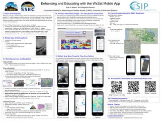
  • 1. Enhancing and Educating with the WxSat Mobile App Kyle A. Nelson1 and Margaret Mooney2 Cooperative Institute for Meteorological Satellite Studies (CIMSS), University of Wisconsin-Madison Contact Information: 1wxkylenelson@gmail.com 2margaret.mooney@ssec.wisc.edu I. Vision and Proposal With ease of access to satellite imagery online and its display increasingly often in local and national TV weather segments, interest is growing. If we are to become a more Weather Ready Nation, it is critical to enhance the weather literacy of the general public, weather enthusiasts and decision-makers worldwide who view satellite and other earth data products and use them to make informed decisions. For this FUNding Friday project, I set out to achieve two goals: 1.  to enhance the free WxSat mobile app to add selectable IR and WV color table enhancements in addition to the black and white Visible, IR and WV imagery. 2.  Add a tutorial for Visible, IR and WV imagery with static annotated images to highlight examples of features often seen in these imagery types and to aid the user in better interpreting what the image is showing and how it relates to them at ground level. III. Web Map Service and RealEarth V. WxSat: Now More Powerful Than Ever Before II. WxSat App: A Starting Point VI. Future Collaborations for SSEC RealEarthIV. Product Information Pages – An Educational Component VIII. Release Information •  Expect upgraded WxSat release in Early 2015; The upgrade will be FREE! •  Current WxSat users will receive an upgrade notification in their App Store What is WMS? •  OGC-compliant method for serving geo-referenced images & data to different client types •  OGC = Open Geospatial Consortium What is RealEarth? •  A distributable framework for ingesting and managing geospatial data for serving to a variety of clients: •  Tile services: Google Maps, iOS App, Android App •  GIS software; KML (Google Earth); THREDDS (data discovery) •  Provides an environment to scientists and researchers to upload data: geolocated images, products, and observations •  Facilitates research by providing the ability to animate through time, layer time-matched data, and probe interactively. •  Enables visualization of data via web browsers, GIS tools, and mobile device apps •  Helps outreach activities by making it easy for anyone to view the products in a webpage or on phones and tablets. •  Shares results and displays through unique URLs, Facebook, Twitter, etc. to allow other researchers and the public to view these products in near real-time Technical Overview •  Ingest: Many formats (PROJ4); Simple HTTP upload •  Management: Metadata; Arbitrary product size •  Serving: •  Tiles: Rectangles of partial images •  Shapes: Plots of data values •  Data probes: Pop up windows of additional information at specific location •  Architecture: 8GB Linux Virtual Machine using HTTP for all access •  Proxy to Other VMs •  Proxy collects and combines information (tiles, shapes, metadata, etc) from the appropriate host and returns the result to the client •  The curation of 25 mobile-friendly product information web pages establishes the WxSat app and reaffirms SSEC RealEarth as educational earth science data viewers. •  The information pages provide users with a qualitative explanation of the product being viewed, using plain language so that readers will not be bombarded by jargon and acronyms commonly used in the atmospheric sciences •  Pages are accessed via the “I” or information icon in RealEarth and WxSat •  A pop-up info window (RealEarth) or an external web page (WxSat) will display the info • GOES-R derived products • Wildfire detection • Lightning detection • Cloud properties • Clear sky mask • Rain rate • Etc… (http://www.goes-r.gov/products/baseline.html) • DOT • Winter road conditions across state lines • Pilot Training System • Flight basemaps • NOTAMs, SIGMETS, etc. • Custom App Versions • Easier Product Navigation • Narrow Focus Special Thanks: •  Margaret Mooney for her guidance and mentorship on this project •  ESIP Education Committee for a phenominal year as a Student Fellow •  FUNding Friday awards committee and donators for project funding •  Dave Parker, SSEC Primary Architect and Programmer, for his coding expertise •  Tommy Jasmin, SSEC Systems Developer, for his programming expertise •  Erik Gould for design and curation of product information pages VII. Access SSEC RealEarth and Download WxSat now! SSEC RealEarth (http://re.ssec.wisc.edu) WxSat – Apple iOS WxSat - Android Cleaner display Custom layering Create favorites Explore! More configurable More products •  Available for iOS and Android •  Features •  Global Visible, Infrared and Water Vapor images •  6-hour imagery loops •  Leverages RealEarth Map Service •  Expandable By expanding the available datasets beyond the original Visible, Infrared and Water Vapor satellite imagery, WxSat becomes a powerful and robust real-time weather analysis and case study tool for the public, scientists and decision makers.