SlideShare a Scribd company logo
1 of 4
Elevation Hydrology Tools
“A streamlined and Simplified Approach”
Kent Peña
State GIS Coordinator
Adolfo Díaz
MLRA GIS Specialist
*special thanks to Peter Mead MN NRCS, he started it all!
The Nuts & Bolts
• The tools are just a toolbox…no install
• Leverage the use of clipping to an AOI to reduce data size
• Streamline the creation of flow direction, accumulation
and stream network derivatives
• Watershed delineation and associated attributes, area,
average slope, runoff curve number etc.
• Creation of pool storage layers
Overview of various unique python scripting solutions that
were used
“So, what is a Runoff Curve Number?”
The runoff curve number (also called a curve number or simply CN) is an
empirical parameter used in hydrology for predicting direct runoff or infiltration
from rainfall excess.
It is widely used and is an efficient method for determining the approximate
amount of direct runoff from a rainfall event in a particular area.
Runoff Curve Numbers are calculated based on land cover and hydrologic
soil group.
Elevation hydrology tools   kent pena

More Related Content

What's hot

3D Analyst - Watershed, Tomohon
3D Analyst - Watershed, Tomohon3D Analyst - Watershed, Tomohon
3D Analyst - Watershed, TomohonHartanto Sanjaya
 
3D Analyst - Watershed Lorelindu
3D Analyst - Watershed Lorelindu3D Analyst - Watershed Lorelindu
3D Analyst - Watershed LorelinduHartanto Sanjaya
 
Atmos - Tom hartley - Modelling Bird Behaviour to Progress Wind Farm Development
Atmos - Tom hartley - Modelling Bird Behaviour to Progress Wind Farm DevelopmentAtmos - Tom hartley - Modelling Bird Behaviour to Progress Wind Farm Development
Atmos - Tom hartley - Modelling Bird Behaviour to Progress Wind Farm DevelopmentEsri UK
 
Watershed Delineation Using ArcMap
Watershed Delineation Using ArcMapWatershed Delineation Using ArcMap
Watershed Delineation Using ArcMapArthur Green
 
Tutorialinterpolationam en
Tutorialinterpolationam enTutorialinterpolationam en
Tutorialinterpolationam enitour21
 
Bluesky - Esri UK Annual Conference 2016
Bluesky - Esri UK Annual Conference 2016Bluesky - Esri UK Annual Conference 2016
Bluesky - Esri UK Annual Conference 2016Esri UK
 
3D Analyst - Watershed from SRTM
3D Analyst - Watershed from SRTM3D Analyst - Watershed from SRTM
3D Analyst - Watershed from SRTMHartanto Sanjaya
 
spatial interoplation in GIS
spatial interoplation in GISspatial interoplation in GIS
spatial interoplation in GISGopalKharka
 
18 - DSS_NIH_Presentation-Sep-17
18 - DSS_NIH_Presentation-Sep-1718 - DSS_NIH_Presentation-Sep-17
18 - DSS_NIH_Presentation-Sep-17indiawrm
 
3D Analyst - Watershed, Padang
3D Analyst - Watershed, Padang3D Analyst - Watershed, Padang
3D Analyst - Watershed, PadangHartanto Sanjaya
 
3D Analyst - Watershed, Lombok
3D Analyst - Watershed, Lombok3D Analyst - Watershed, Lombok
3D Analyst - Watershed, LombokHartanto Sanjaya
 
markus_mueller_eresearchnz2016
markus_mueller_eresearchnz2016markus_mueller_eresearchnz2016
markus_mueller_eresearchnz2016Markus Müller
 
DSD-INT 2015 - Workshop processing with sentinel toolbox - Jos Maccabiani, Sk...
DSD-INT 2015 - Workshop processing with sentinel toolbox - Jos Maccabiani, Sk...DSD-INT 2015 - Workshop processing with sentinel toolbox - Jos Maccabiani, Sk...
DSD-INT 2015 - Workshop processing with sentinel toolbox - Jos Maccabiani, Sk...Deltares
 
Watershed Delineation in ArcGIS
Watershed Delineation in ArcGISWatershed Delineation in ArcGIS
Watershed Delineation in ArcGISArthur Green
 
Modelling of Short Duration Isopluvial Map For Raichur District Karnataka Moh...
Modelling of Short Duration Isopluvial Map For Raichur District Karnataka Moh...Modelling of Short Duration Isopluvial Map For Raichur District Karnataka Moh...
Modelling of Short Duration Isopluvial Map For Raichur District Karnataka Moh...Mohammed Badiuddin Parvez
 
GIS for Infrastructure Management
GIS for Infrastructure ManagementGIS for Infrastructure Management
GIS for Infrastructure ManagementDavid Puckett
 
Conjunuse
ConjunuseConjunuse
ConjunuseNH Rao
 
SC7 Workshop 3: Big Data Challenges in Building a Global Earth Observation Sy...
SC7 Workshop 3: Big Data Challenges in Building a Global Earth Observation Sy...SC7 Workshop 3: Big Data Challenges in Building a Global Earth Observation Sy...
SC7 Workshop 3: Big Data Challenges in Building a Global Earth Observation Sy...BigData_Europe
 

What's hot (20)

3D Analyst - Watershed, Tomohon
3D Analyst - Watershed, Tomohon3D Analyst - Watershed, Tomohon
3D Analyst - Watershed, Tomohon
 
3D Analyst - Watershed Lorelindu
3D Analyst - Watershed Lorelindu3D Analyst - Watershed Lorelindu
3D Analyst - Watershed Lorelindu
 
Atmos - Tom hartley - Modelling Bird Behaviour to Progress Wind Farm Development
Atmos - Tom hartley - Modelling Bird Behaviour to Progress Wind Farm DevelopmentAtmos - Tom hartley - Modelling Bird Behaviour to Progress Wind Farm Development
Atmos - Tom hartley - Modelling Bird Behaviour to Progress Wind Farm Development
 
Watershed Delineation Using ArcMap
Watershed Delineation Using ArcMapWatershed Delineation Using ArcMap
Watershed Delineation Using ArcMap
 
Tutorialinterpolationam en
Tutorialinterpolationam enTutorialinterpolationam en
Tutorialinterpolationam en
 
Bluesky - Esri UK Annual Conference 2016
Bluesky - Esri UK Annual Conference 2016Bluesky - Esri UK Annual Conference 2016
Bluesky - Esri UK Annual Conference 2016
 
3D Watershed Celebes
3D Watershed Celebes3D Watershed Celebes
3D Watershed Celebes
 
3D Analyst - Watershed from SRTM
3D Analyst - Watershed from SRTM3D Analyst - Watershed from SRTM
3D Analyst - Watershed from SRTM
 
Flood plain mapping
Flood plain mappingFlood plain mapping
Flood plain mapping
 
spatial interoplation in GIS
spatial interoplation in GISspatial interoplation in GIS
spatial interoplation in GIS
 
18 - DSS_NIH_Presentation-Sep-17
18 - DSS_NIH_Presentation-Sep-1718 - DSS_NIH_Presentation-Sep-17
18 - DSS_NIH_Presentation-Sep-17
 
3D Analyst - Watershed, Padang
3D Analyst - Watershed, Padang3D Analyst - Watershed, Padang
3D Analyst - Watershed, Padang
 
3D Analyst - Watershed, Lombok
3D Analyst - Watershed, Lombok3D Analyst - Watershed, Lombok
3D Analyst - Watershed, Lombok
 
markus_mueller_eresearchnz2016
markus_mueller_eresearchnz2016markus_mueller_eresearchnz2016
markus_mueller_eresearchnz2016
 
DSD-INT 2015 - Workshop processing with sentinel toolbox - Jos Maccabiani, Sk...
DSD-INT 2015 - Workshop processing with sentinel toolbox - Jos Maccabiani, Sk...DSD-INT 2015 - Workshop processing with sentinel toolbox - Jos Maccabiani, Sk...
DSD-INT 2015 - Workshop processing with sentinel toolbox - Jos Maccabiani, Sk...
 
Watershed Delineation in ArcGIS
Watershed Delineation in ArcGISWatershed Delineation in ArcGIS
Watershed Delineation in ArcGIS
 
Modelling of Short Duration Isopluvial Map For Raichur District Karnataka Moh...
Modelling of Short Duration Isopluvial Map For Raichur District Karnataka Moh...Modelling of Short Duration Isopluvial Map For Raichur District Karnataka Moh...
Modelling of Short Duration Isopluvial Map For Raichur District Karnataka Moh...
 
GIS for Infrastructure Management
GIS for Infrastructure ManagementGIS for Infrastructure Management
GIS for Infrastructure Management
 
Conjunuse
ConjunuseConjunuse
Conjunuse
 
SC7 Workshop 3: Big Data Challenges in Building a Global Earth Observation Sy...
SC7 Workshop 3: Big Data Challenges in Building a Global Earth Observation Sy...SC7 Workshop 3: Big Data Challenges in Building a Global Earth Observation Sy...
SC7 Workshop 3: Big Data Challenges in Building a Global Earth Observation Sy...
 

Viewers also liked (6)

Wisconsin SCO Virtual Data Integration
Wisconsin SCO Virtual Data IntegrationWisconsin SCO Virtual Data Integration
Wisconsin SCO Virtual Data Integration
 
Integrative mapping strategies jeremy bixby
Integrative mapping strategies   jeremy bixbyIntegrative mapping strategies   jeremy bixby
Integrative mapping strategies jeremy bixby
 
Open source web mapping system launch and demonstration andy swartz
Open source web mapping system launch and demonstration   andy swartzOpen source web mapping system launch and demonstration   andy swartz
Open source web mapping system launch and demonstration andy swartz
 
2009 Fall Regional - GIS and Wildfire Management
2009 Fall Regional - GIS and Wildfire Management2009 Fall Regional - GIS and Wildfire Management
2009 Fall Regional - GIS and Wildfire Management
 
Spring 2010 SAGIC Perspective
Spring 2010 SAGIC PerspectiveSpring 2010 SAGIC Perspective
Spring 2010 SAGIC Perspective
 
Vilas County Invasive Species Program
Vilas County Invasive Species ProgramVilas County Invasive Species Program
Vilas County Invasive Species Program
 

Similar to Elevation hydrology tools kent pena

Extreme Event-based Rainfal.pptx
Extreme Event-based Rainfal.pptxExtreme Event-based Rainfal.pptx
Extreme Event-based Rainfal.pptxAlthafMk2
 
7 - AECOM Water Resources Seminar World Bank -16-Sept
7 - AECOM Water Resources Seminar World Bank -16-Sept7 - AECOM Water Resources Seminar World Bank -16-Sept
7 - AECOM Water Resources Seminar World Bank -16-Septindiawrm
 
Seven Most tenable applications of AI o Water Resources Management
Seven Most tenable applications of AI o Water Resources ManagementSeven Most tenable applications of AI o Water Resources Management
Seven Most tenable applications of AI o Water Resources ManagementMrinmoy Majumder
 
Rahul Bajpai M.tech Remote sensing & GIS RSACUP
Rahul Bajpai M.tech Remote sensing & GIS RSACUPRahul Bajpai M.tech Remote sensing & GIS RSACUP
Rahul Bajpai M.tech Remote sensing & GIS RSACUPrahul64
 
Application of remote sensing and gis for groundwater
Application of remote sensing and gis for groundwaterApplication of remote sensing and gis for groundwater
Application of remote sensing and gis for groundwaterRamodh Jayawardena
 
A Deep Learning use case for water end use detection by Roberto Díaz and José...
A Deep Learning use case for water end use detection by Roberto Díaz and José...A Deep Learning use case for water end use detection by Roberto Díaz and José...
A Deep Learning use case for water end use detection by Roberto Díaz and José...Big Data Spain
 
Two Dimensional Flood Inundation Modelling In Urban Area Using WMS, HEC-RAS a...
Two Dimensional Flood Inundation Modelling In Urban Area Using WMS, HEC-RAS a...Two Dimensional Flood Inundation Modelling In Urban Area Using WMS, HEC-RAS a...
Two Dimensional Flood Inundation Modelling In Urban Area Using WMS, HEC-RAS a...Amro Elfeki
 
2016 conservation track: evaluating lidar derived synthetic streams as a ...
2016 conservation track: evaluating   lidar derived   synthetic streams as a ...2016 conservation track: evaluating   lidar derived   synthetic streams as a ...
2016 conservation track: evaluating lidar derived synthetic streams as a ...GIS in the Rockies
 
Application of Remote Sensing and GIS Technology for Pre and Post Flood Analy...
Application of Remote Sensing and GIS Technology for Pre and Post Flood Analy...Application of Remote Sensing and GIS Technology for Pre and Post Flood Analy...
Application of Remote Sensing and GIS Technology for Pre and Post Flood Analy...Uzma Fatima Ch.
 
Delineating high crash locations with the use of GIS
Delineating high crash locations with the use of GISDelineating high crash locations with the use of GIS
Delineating high crash locations with the use of GISSunil Gyawali
 
Integrated disaster management system and emergency management system
Integrated disaster management system and emergency management systemIntegrated disaster management system and emergency management system
Integrated disaster management system and emergency management systemYoungTae (Henry) Huh
 
Lidar and radar.pptx
Lidar and radar.pptxLidar and radar.pptx
Lidar and radar.pptxBivaYadav3
 
069MSW405_Devendra Tamrakar_Presentation
069MSW405_Devendra Tamrakar_Presentation069MSW405_Devendra Tamrakar_Presentation
069MSW405_Devendra Tamrakar_PresentationDevendra Tamrakar
 
APPLICATIONS OF RS AND GIS FOR DEVELOPMENT OF SMALL HYDROPOWER PLANTS (SHP)
APPLICATIONS OF RS AND GIS  FOR DEVELOPMENT OF SMALL HYDROPOWER PLANTS (SHP)APPLICATIONS OF RS AND GIS  FOR DEVELOPMENT OF SMALL HYDROPOWER PLANTS (SHP)
APPLICATIONS OF RS AND GIS FOR DEVELOPMENT OF SMALL HYDROPOWER PLANTS (SHP)Abhiram Kanigolla
 
Discharge-Forecasting-of-Mahanadi-River-Basin.pptx
Discharge-Forecasting-of-Mahanadi-River-Basin.pptxDischarge-Forecasting-of-Mahanadi-River-Basin.pptx
Discharge-Forecasting-of-Mahanadi-River-Basin.pptxSubhadeepSahu4
 
Real-time Geographic Information System (GIS) for.pptx
Real-time Geographic Information System (GIS) for.pptxReal-time Geographic Information System (GIS) for.pptx
Real-time Geographic Information System (GIS) for.pptxssuser32a23a1
 
Mandira singh shrestha
Mandira singh shrestha Mandira singh shrestha
Mandira singh shrestha ClimDev15
 
Geospatial Open Data and Urban Growth Modelling for Evidence-based Decision M...
Geospatial Open Data and Urban Growth Modelling for Evidence-based Decision M...Geospatial Open Data and Urban Growth Modelling for Evidence-based Decision M...
Geospatial Open Data and Urban Growth Modelling for Evidence-based Decision M...Piyush Yadav
 

Similar to Elevation hydrology tools kent pena (20)

Extreme Event-based Rainfal.pptx
Extreme Event-based Rainfal.pptxExtreme Event-based Rainfal.pptx
Extreme Event-based Rainfal.pptx
 
7 - AECOM Water Resources Seminar World Bank -16-Sept
7 - AECOM Water Resources Seminar World Bank -16-Sept7 - AECOM Water Resources Seminar World Bank -16-Sept
7 - AECOM Water Resources Seminar World Bank -16-Sept
 
Seven Most tenable applications of AI o Water Resources Management
Seven Most tenable applications of AI o Water Resources ManagementSeven Most tenable applications of AI o Water Resources Management
Seven Most tenable applications of AI o Water Resources Management
 
Rahul Bajpai M.tech Remote sensing & GIS RSACUP
Rahul Bajpai M.tech Remote sensing & GIS RSACUPRahul Bajpai M.tech Remote sensing & GIS RSACUP
Rahul Bajpai M.tech Remote sensing & GIS RSACUP
 
Application of remote sensing and gis for groundwater
Application of remote sensing and gis for groundwaterApplication of remote sensing and gis for groundwater
Application of remote sensing and gis for groundwater
 
GIS-WaterSector (1).pptx
GIS-WaterSector (1).pptxGIS-WaterSector (1).pptx
GIS-WaterSector (1).pptx
 
INCENDIA
INCENDIAINCENDIA
INCENDIA
 
A Deep Learning use case for water end use detection by Roberto Díaz and José...
A Deep Learning use case for water end use detection by Roberto Díaz and José...A Deep Learning use case for water end use detection by Roberto Díaz and José...
A Deep Learning use case for water end use detection by Roberto Díaz and José...
 
Two Dimensional Flood Inundation Modelling In Urban Area Using WMS, HEC-RAS a...
Two Dimensional Flood Inundation Modelling In Urban Area Using WMS, HEC-RAS a...Two Dimensional Flood Inundation Modelling In Urban Area Using WMS, HEC-RAS a...
Two Dimensional Flood Inundation Modelling In Urban Area Using WMS, HEC-RAS a...
 
2016 conservation track: evaluating lidar derived synthetic streams as a ...
2016 conservation track: evaluating   lidar derived   synthetic streams as a ...2016 conservation track: evaluating   lidar derived   synthetic streams as a ...
2016 conservation track: evaluating lidar derived synthetic streams as a ...
 
Application of Remote Sensing and GIS Technology for Pre and Post Flood Analy...
Application of Remote Sensing and GIS Technology for Pre and Post Flood Analy...Application of Remote Sensing and GIS Technology for Pre and Post Flood Analy...
Application of Remote Sensing and GIS Technology for Pre and Post Flood Analy...
 
Delineating high crash locations with the use of GIS
Delineating high crash locations with the use of GISDelineating high crash locations with the use of GIS
Delineating high crash locations with the use of GIS
 
Integrated disaster management system and emergency management system
Integrated disaster management system and emergency management systemIntegrated disaster management system and emergency management system
Integrated disaster management system and emergency management system
 
Lidar and radar.pptx
Lidar and radar.pptxLidar and radar.pptx
Lidar and radar.pptx
 
069MSW405_Devendra Tamrakar_Presentation
069MSW405_Devendra Tamrakar_Presentation069MSW405_Devendra Tamrakar_Presentation
069MSW405_Devendra Tamrakar_Presentation
 
APPLICATIONS OF RS AND GIS FOR DEVELOPMENT OF SMALL HYDROPOWER PLANTS (SHP)
APPLICATIONS OF RS AND GIS  FOR DEVELOPMENT OF SMALL HYDROPOWER PLANTS (SHP)APPLICATIONS OF RS AND GIS  FOR DEVELOPMENT OF SMALL HYDROPOWER PLANTS (SHP)
APPLICATIONS OF RS AND GIS FOR DEVELOPMENT OF SMALL HYDROPOWER PLANTS (SHP)
 
Discharge-Forecasting-of-Mahanadi-River-Basin.pptx
Discharge-Forecasting-of-Mahanadi-River-Basin.pptxDischarge-Forecasting-of-Mahanadi-River-Basin.pptx
Discharge-Forecasting-of-Mahanadi-River-Basin.pptx
 
Real-time Geographic Information System (GIS) for.pptx
Real-time Geographic Information System (GIS) for.pptxReal-time Geographic Information System (GIS) for.pptx
Real-time Geographic Information System (GIS) for.pptx
 
Mandira singh shrestha
Mandira singh shrestha Mandira singh shrestha
Mandira singh shrestha
 
Geospatial Open Data and Urban Growth Modelling for Evidence-based Decision M...
Geospatial Open Data and Urban Growth Modelling for Evidence-based Decision M...Geospatial Open Data and Urban Growth Modelling for Evidence-based Decision M...
Geospatial Open Data and Urban Growth Modelling for Evidence-based Decision M...
 

More from Wisconsin Land Information Association

Workshop using open source software for mobile data collection workshop - a...
Workshop   using open source software for mobile data collection workshop - a...Workshop   using open source software for mobile data collection workshop - a...
Workshop using open source software for mobile data collection workshop - a...Wisconsin Land Information Association
 
Mapping spatial patterns of whai finder usage to measure community outreach e...
Mapping spatial patterns of whai finder usage to measure community outreach e...Mapping spatial patterns of whai finder usage to measure community outreach e...
Mapping spatial patterns of whai finder usage to measure community outreach e...Wisconsin Land Information Association
 
Lakesheds and riverscapes extending wisconsin's hydro database with landsca...
Lakesheds and riverscapes   extending wisconsin's hydro database with landsca...Lakesheds and riverscapes   extending wisconsin's hydro database with landsca...
Lakesheds and riverscapes extending wisconsin's hydro database with landsca...Wisconsin Land Information Association
 
Lake habitat mapping with side scan sonar in nine wisconsin lakes - christine...
Lake habitat mapping with side scan sonar in nine wisconsin lakes - christine...Lake habitat mapping with side scan sonar in nine wisconsin lakes - christine...
Lake habitat mapping with side scan sonar in nine wisconsin lakes - christine...Wisconsin Land Information Association
 
Integrating sanitary televising data with utility gis data within the city of...
Integrating sanitary televising data with utility gis data within the city of...Integrating sanitary televising data with utility gis data within the city of...
Integrating sanitary televising data with utility gis data within the city of...Wisconsin Land Information Association
 
Integrating high accuracy gps with esri's arc gis for windows mobile field so...
Integrating high accuracy gps with esri's arc gis for windows mobile field so...Integrating high accuracy gps with esri's arc gis for windows mobile field so...
Integrating high accuracy gps with esri's arc gis for windows mobile field so...Wisconsin Land Information Association
 
Implementing arc gis 10.1 for the wisconsin dnr nhi portal levi felling
Implementing arc gis 10.1 for the wisconsin dnr nhi portal   levi fellingImplementing arc gis 10.1 for the wisconsin dnr nhi portal   levi felling
Implementing arc gis 10.1 for the wisconsin dnr nhi portal levi fellingWisconsin Land Information Association
 
City of ashland an analysis of mobile gis through amazon elastic cloud comp...
City of ashland   an analysis of mobile gis through amazon elastic cloud comp...City of ashland   an analysis of mobile gis through amazon elastic cloud comp...
City of ashland an analysis of mobile gis through amazon elastic cloud comp...Wisconsin Land Information Association
 

More from Wisconsin Land Information Association (20)

Airphoto anomilies
Airphoto anomiliesAirphoto anomilies
Airphoto anomilies
 
A wikimap of landscape values in the bad river watershed carl sack
A wikimap of landscape values in the bad river watershed   carl sackA wikimap of landscape values in the bad river watershed   carl sack
A wikimap of landscape values in the bad river watershed carl sack
 
Workshop using open source software for mobile data collection workshop - a...
Workshop   using open source software for mobile data collection workshop - a...Workshop   using open source software for mobile data collection workshop - a...
Workshop using open source software for mobile data collection workshop - a...
 
Wigicc's role in wisconsin jon schwitchtenberg
Wigicc's role in wisconsin   jon schwitchtenbergWigicc's role in wisconsin   jon schwitchtenberg
Wigicc's role in wisconsin jon schwitchtenberg
 
Wi 590 nutrient management web application lisa morrison
Wi 590 nutrient management web application   lisa morrisonWi 590 nutrient management web application   lisa morrison
Wi 590 nutrient management web application lisa morrison
 
Surveying and land records management dean roth
Surveying and land records management   dean rothSurveying and land records management   dean roth
Surveying and land records management dean roth
 
Mapping spatial patterns of whai finder usage to measure community outreach e...
Mapping spatial patterns of whai finder usage to measure community outreach e...Mapping spatial patterns of whai finder usage to measure community outreach e...
Mapping spatial patterns of whai finder usage to measure community outreach e...
 
Local gis in the statewide voter registration system sarah whitt
Local gis in the statewide voter registration system   sarah whittLocal gis in the statewide voter registration system   sarah whitt
Local gis in the statewide voter registration system sarah whitt
 
Li dar quality control a client's perspective - tyler grosshuesch
Li dar quality control   a client's perspective - tyler grosshueschLi dar quality control   a client's perspective - tyler grosshuesch
Li dar quality control a client's perspective - tyler grosshuesch
 
Li dar meets wisconsinview jc nelson
Li dar meets wisconsinview   jc nelsonLi dar meets wisconsinview   jc nelson
Li dar meets wisconsinview jc nelson
 
Lakesheds and riverscapes extending wisconsin's hydro database with landsca...
Lakesheds and riverscapes   extending wisconsin's hydro database with landsca...Lakesheds and riverscapes   extending wisconsin's hydro database with landsca...
Lakesheds and riverscapes extending wisconsin's hydro database with landsca...
 
Lake habitat mapping with side scan sonar in nine wisconsin lakes - christine...
Lake habitat mapping with side scan sonar in nine wisconsin lakes - christine...Lake habitat mapping with side scan sonar in nine wisconsin lakes - christine...
Lake habitat mapping with side scan sonar in nine wisconsin lakes - christine...
 
Integrating sanitary televising data with utility gis data within the city of...
Integrating sanitary televising data with utility gis data within the city of...Integrating sanitary televising data with utility gis data within the city of...
Integrating sanitary televising data with utility gis data within the city of...
 
Integrating high accuracy gps with esri's arc gis for windows mobile field so...
Integrating high accuracy gps with esri's arc gis for windows mobile field so...Integrating high accuracy gps with esri's arc gis for windows mobile field so...
Integrating high accuracy gps with esri's arc gis for windows mobile field so...
 
Implementing arc gis 10.1 for the wisconsin dnr nhi portal levi felling
Implementing arc gis 10.1 for the wisconsin dnr nhi portal   levi fellingImplementing arc gis 10.1 for the wisconsin dnr nhi portal   levi felling
Implementing arc gis 10.1 for the wisconsin dnr nhi portal levi felling
 
Gis in parks and recreation the proragis website - trish nau
Gis in parks and recreation   the proragis website - trish nauGis in parks and recreation   the proragis website - trish nau
Gis in parks and recreation the proragis website - trish nau
 
Geo moose project update brian fischer
Geo moose project update   brian fischerGeo moose project update   brian fischer
Geo moose project update brian fischer
 
Developing mobile apps pick your poison - levi felling
Developing mobile apps   pick your poison - levi fellingDeveloping mobile apps   pick your poison - levi felling
Developing mobile apps pick your poison - levi felling
 
City of ashland an analysis of mobile gis through amazon elastic cloud comp...
City of ashland   an analysis of mobile gis through amazon elastic cloud comp...City of ashland   an analysis of mobile gis through amazon elastic cloud comp...
City of ashland an analysis of mobile gis through amazon elastic cloud comp...
 
A Journey Through Mobile Application Development - Brian Fischer
A Journey Through Mobile Application Development - Brian FischerA Journey Through Mobile Application Development - Brian Fischer
A Journey Through Mobile Application Development - Brian Fischer
 

Elevation hydrology tools kent pena

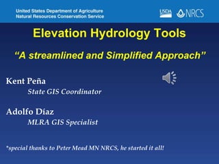
  • 1. Elevation Hydrology Tools “A streamlined and Simplified Approach” Kent Peña State GIS Coordinator Adolfo Díaz MLRA GIS Specialist *special thanks to Peter Mead MN NRCS, he started it all!
  • 2. The Nuts & Bolts • The tools are just a toolbox…no install • Leverage the use of clipping to an AOI to reduce data size • Streamline the creation of flow direction, accumulation and stream network derivatives • Watershed delineation and associated attributes, area, average slope, runoff curve number etc. • Creation of pool storage layers Overview of various unique python scripting solutions that were used
  • 3. “So, what is a Runoff Curve Number?” The runoff curve number (also called a curve number or simply CN) is an empirical parameter used in hydrology for predicting direct runoff or infiltration from rainfall excess. It is widely used and is an efficient method for determining the approximate amount of direct runoff from a rainfall event in a particular area. Runoff Curve Numbers are calculated based on land cover and hydrologic soil group.