SlideShare a Scribd company logo
1 of 24
ARCHER TRAC TECHNICIAN T otal   R econ   A wareness   C ontrol
[object Object],[object Object],[object Object],[object Object],[object Object],ARCHER TRAC TECHNICIAN
[object Object],[object Object],[object Object],[object Object],[object Object]
Learning Objectives
Learning Objectives ,[object Object],[object Object],[object Object],[object Object],[object Object],[object Object],[object Object],[object Object]
Learning Objectives ,[object Object],[object Object],[object Object],[object Object],[object Object]
ARCHER Hardware
ARCHER Hardware The ARCHER airborne system contains an advanced hyperspectral imaging sensor and a panchromatic high-resolution imaging camera.  ARCHER also contains a GPS  and inertial navigation system.  Together, these components allow the system to accurately position each pixel on a virtual map during a mission.  The ARCHER TRAC pc receives aircraft position, heading, attitude, and altitude AGL information from the ARCHER system.
ARCHER Hardware After the mission flight is complete, the data obtained by the sensors can be easily transferred to the ARCHER ground station.  The ground station has the same advanced data processing capabilities as the airborne system. With two high-resolution monitors, the mission data can be replayed for further analysis, in-depth review, or training. The second monitor allows the chip viewer to be displayed simultaneously with the plotted search area image.
ARCHER Hardware Simultaneously with the real-time  imagery processing, ARCHER plots  the ground area swept by the sensors  on a handheld tablet PC designated  ARCHER TRAC.  ARCHER TRAC is  a mission navigation and tracking tool that helps  the crew ensure that imagery data is collected from the entire search area. Key waypoints are easily programmed into  ARCHER TRAC. The ground area that is covered by the ARCHER sensors is superimposed on a standard  aviation sectional map.
System Interaction
HSI Sensor Resolution ,[object Object],[object Object]
GPS/INS ,[object Object],[object Object]
Target Detection ,[object Object],[object Object],[object Object],[object Object]
Illumination Requirements Illumination Guideline If you can  clearly  see objects on the ground, then there is enough light for ARCHER.
Illumination Requirements ,[object Object],[object Object],[object Object],[object Object],[object Object],[object Object]
ARCHER TRAC  Tablet PC-based real-time mission navigation aid
ARCHER TRAC  ,[object Object],[object Object],[object Object],[object Object],[object Object]
Module review ,[object Object],[object Object],[object Object],[object Object],[object Object],[object Object],[object Object],[object Object]
Module review ,[object Object],[object Object],[object Object],[object Object],[object Object]
Module review ,[object Object],[object Object],[object Object],[object Object],[object Object],[object Object],[object Object],[object Object]
Module review ,[object Object],[object Object]
Reference Documents ,[object Object],[object Object],[object Object],[object Object],[object Object]
 

More Related Content

What's hot

Aerospace applications of Perl
Aerospace applications of PerlAerospace applications of Perl
Aerospace applications of PerlIan Kluft
 
Android GPS Tutorial
Android GPS TutorialAndroid GPS Tutorial
Android GPS TutorialAhsanul Karim
 
Global Positioning System
Global Positioning System Global Positioning System
Global Positioning System Himanshu Agrawal
 
Global positioning system ppt
Global positioning system pptGlobal positioning system ppt
Global positioning system pptSwapnil Ramgirwar
 
Combined Complementary Filter For Inertial Navigation System
Combined Complementary Filter For Inertial Navigation SystemCombined Complementary Filter For Inertial Navigation System
Combined Complementary Filter For Inertial Navigation SystemMykola Novik
 
DIFFERENTIAL GPS
DIFFERENTIAL GPSDIFFERENTIAL GPS
DIFFERENTIAL GPSj_rahul
 
DIFFERENTIAL GPS (DGPS)
DIFFERENTIAL GPS (DGPS)DIFFERENTIAL GPS (DGPS)
DIFFERENTIAL GPS (DGPS)KU Leuven
 
GPS (Global Positioning System)
GPS (Global Positioning System)GPS (Global Positioning System)
GPS (Global Positioning System)tahirilyas92
 
Global positioning system GPS
Global positioning system GPSGlobal positioning system GPS
Global positioning system GPSEmmad Cheema
 
Indian satellite based navigation system description and implementation status
Indian satellite based navigation system description and implementation statusIndian satellite based navigation system description and implementation status
Indian satellite based navigation system description and implementation statushuangxj73
 
GLOBAL POSITIONING SYSTEM (GPS)
GLOBAL POSITIONING SYSTEM (GPS) GLOBAL POSITIONING SYSTEM (GPS)
GLOBAL POSITIONING SYSTEM (GPS) Md. Sumon Fakir
 
Gps ins odometer data fusion
Gps ins odometer data fusionGps ins odometer data fusion
Gps ins odometer data fusionRappy Saha
 

What's hot (19)

Aerospace applications of Perl
Aerospace applications of PerlAerospace applications of Perl
Aerospace applications of Perl
 
Android GPS Tutorial
Android GPS TutorialAndroid GPS Tutorial
Android GPS Tutorial
 
Global Positioning System
Global Positioning System Global Positioning System
Global Positioning System
 
Global positioning system ppt
Global positioning system pptGlobal positioning system ppt
Global positioning system ppt
 
Differential gps
Differential gpsDifferential gps
Differential gps
 
Combined Complementary Filter For Inertial Navigation System
Combined Complementary Filter For Inertial Navigation SystemCombined Complementary Filter For Inertial Navigation System
Combined Complementary Filter For Inertial Navigation System
 
GPS
GPSGPS
GPS
 
Gps tracking system
Gps tracking system Gps tracking system
Gps tracking system
 
DIFFERENTIAL GPS
DIFFERENTIAL GPSDIFFERENTIAL GPS
DIFFERENTIAL GPS
 
NERC Presentation
NERC PresentationNERC Presentation
NERC Presentation
 
DIFFERENTIAL GPS (DGPS)
DIFFERENTIAL GPS (DGPS)DIFFERENTIAL GPS (DGPS)
DIFFERENTIAL GPS (DGPS)
 
Gps
GpsGps
Gps
 
GPS (Global Positioning System)
GPS (Global Positioning System)GPS (Global Positioning System)
GPS (Global Positioning System)
 
Global positioning system GPS
Global positioning system GPSGlobal positioning system GPS
Global positioning system GPS
 
200911 mbt-ai4_a_dintm__presentation
200911  mbt-ai4_a_dintm__presentation200911  mbt-ai4_a_dintm__presentation
200911 mbt-ai4_a_dintm__presentation
 
Indian satellite based navigation system description and implementation status
Indian satellite based navigation system description and implementation statusIndian satellite based navigation system description and implementation status
Indian satellite based navigation system description and implementation status
 
GLOBAL POSITIONING SYSTEM (GPS)
GLOBAL POSITIONING SYSTEM (GPS) GLOBAL POSITIONING SYSTEM (GPS)
GLOBAL POSITIONING SYSTEM (GPS)
 
Gps ins odometer data fusion
Gps ins odometer data fusionGps ins odometer data fusion
Gps ins odometer data fusion
 
IRNSS
IRNSSIRNSS
IRNSS
 

Similar to Archer trac module_1_-_intro_v1

AAI Bhopal, Training Presentation (CNS)
AAI Bhopal, Training Presentation (CNS)AAI Bhopal, Training Presentation (CNS)
AAI Bhopal, Training Presentation (CNS)Vaibhav Mishra
 
Small-Scale Payload Operations Simulator for Proximity Operations Paper
Small-Scale Payload Operations Simulator for Proximity Operations PaperSmall-Scale Payload Operations Simulator for Proximity Operations Paper
Small-Scale Payload Operations Simulator for Proximity Operations PaperJared Cokley
 
trainingpresentation-180628160709.pptx
trainingpresentation-180628160709.pptxtrainingpresentation-180628160709.pptx
trainingpresentation-180628160709.pptxChitranshKadare
 
Aerospace defensetechs
Aerospace  defensetechsAerospace  defensetechs
Aerospace defensetechsalancabe
 
System Architecture Study Global Hawk Unamanned Aerial System (UAS)
System Architecture Study Global Hawk Unamanned Aerial System (UAS)System Architecture Study Global Hawk Unamanned Aerial System (UAS)
System Architecture Study Global Hawk Unamanned Aerial System (UAS)University of Southern California
 
Surveying Innovations in Quarrying
Surveying Innovations in QuarryingSurveying Innovations in Quarrying
Surveying Innovations in QuarryingErik Birzulis
 
Application Of Digital Signal Processing In Radar Signals
Application Of Digital Signal Processing In Radar SignalsApplication Of Digital Signal Processing In Radar Signals
Application Of Digital Signal Processing In Radar SignalsRichard Hogue
 
Karl Hedrick
Karl HedrickKarl Hedrick
Karl HedricksUAS News
 
The Use of GPS Tracking & Guidance Systems for the Chicken LIttle Joint Proje...
The Use of GPS Tracking & Guidance Systems for the Chicken LIttle Joint Proje...The Use of GPS Tracking & Guidance Systems for the Chicken LIttle Joint Proje...
The Use of GPS Tracking & Guidance Systems for the Chicken LIttle Joint Proje...Mark Hardesty
 
Air craft surveillance & instrumental landing system
Air craft surveillance & instrumental landing systemAir craft surveillance & instrumental landing system
Air craft surveillance & instrumental landing systemBikas Sadashiv
 
Remote Sensing Field Camp 2016
Remote Sensing Field Camp 2016 Remote Sensing Field Camp 2016
Remote Sensing Field Camp 2016 COGS Presentations
 
To help ensure safe flights, air traffic controllers enforce a minim.pdf
To help ensure safe flights, air traffic controllers enforce a minim.pdfTo help ensure safe flights, air traffic controllers enforce a minim.pdf
To help ensure safe flights, air traffic controllers enforce a minim.pdfarihantpuneteleshope
 
Implementation of Adaptive Digital Beamforming using Cordic
Implementation of Adaptive Digital Beamforming using CordicImplementation of Adaptive Digital Beamforming using Cordic
Implementation of Adaptive Digital Beamforming using CordicEditor IJCATR
 
Design and Operation of UAV
Design and Operation of UAVDesign and Operation of UAV
Design and Operation of UAVSai Shubhankar
 

Similar to Archer trac module_1_-_intro_v1 (20)

acra
acraacra
acra
 
Cse satrack ppt
Cse satrack pptCse satrack ppt
Cse satrack ppt
 
AAI Bhopal, Training Presentation (CNS)
AAI Bhopal, Training Presentation (CNS)AAI Bhopal, Training Presentation (CNS)
AAI Bhopal, Training Presentation (CNS)
 
ILS.pptx
ILS.pptxILS.pptx
ILS.pptx
 
Small-Scale Payload Operations Simulator for Proximity Operations Paper
Small-Scale Payload Operations Simulator for Proximity Operations PaperSmall-Scale Payload Operations Simulator for Proximity Operations Paper
Small-Scale Payload Operations Simulator for Proximity Operations Paper
 
trainingpresentation-180628160709.pptx
trainingpresentation-180628160709.pptxtrainingpresentation-180628160709.pptx
trainingpresentation-180628160709.pptx
 
Aerospace defensetechs
Aerospace  defensetechsAerospace  defensetechs
Aerospace defensetechs
 
Seban ppt
Seban pptSeban ppt
Seban ppt
 
System Architecture Study Global Hawk Unamanned Aerial System (UAS)
System Architecture Study Global Hawk Unamanned Aerial System (UAS)System Architecture Study Global Hawk Unamanned Aerial System (UAS)
System Architecture Study Global Hawk Unamanned Aerial System (UAS)
 
In sar 1-1-2011
In sar 1-1-2011In sar 1-1-2011
In sar 1-1-2011
 
Surveying Innovations in Quarrying
Surveying Innovations in QuarryingSurveying Innovations in Quarrying
Surveying Innovations in Quarrying
 
Application Of Digital Signal Processing In Radar Signals
Application Of Digital Signal Processing In Radar SignalsApplication Of Digital Signal Processing In Radar Signals
Application Of Digital Signal Processing In Radar Signals
 
Aerophysx Brochure
Aerophysx BrochureAerophysx Brochure
Aerophysx Brochure
 
Karl Hedrick
Karl HedrickKarl Hedrick
Karl Hedrick
 
The Use of GPS Tracking & Guidance Systems for the Chicken LIttle Joint Proje...
The Use of GPS Tracking & Guidance Systems for the Chicken LIttle Joint Proje...The Use of GPS Tracking & Guidance Systems for the Chicken LIttle Joint Proje...
The Use of GPS Tracking & Guidance Systems for the Chicken LIttle Joint Proje...
 
Air craft surveillance & instrumental landing system
Air craft surveillance & instrumental landing systemAir craft surveillance & instrumental landing system
Air craft surveillance & instrumental landing system
 
Remote Sensing Field Camp 2016
Remote Sensing Field Camp 2016 Remote Sensing Field Camp 2016
Remote Sensing Field Camp 2016
 
To help ensure safe flights, air traffic controllers enforce a minim.pdf
To help ensure safe flights, air traffic controllers enforce a minim.pdfTo help ensure safe flights, air traffic controllers enforce a minim.pdf
To help ensure safe flights, air traffic controllers enforce a minim.pdf
 
Implementation of Adaptive Digital Beamforming using Cordic
Implementation of Adaptive Digital Beamforming using CordicImplementation of Adaptive Digital Beamforming using Cordic
Implementation of Adaptive Digital Beamforming using Cordic
 
Design and Operation of UAV
Design and Operation of UAVDesign and Operation of UAV
Design and Operation of UAV
 

Archer trac module_1_-_intro_v1

  • 1. ARCHER TRAC TECHNICIAN T otal R econ A wareness C ontrol
  • 2.
  • 3.
  • 5.
  • 6.
  • 8. ARCHER Hardware The ARCHER airborne system contains an advanced hyperspectral imaging sensor and a panchromatic high-resolution imaging camera. ARCHER also contains a GPS and inertial navigation system. Together, these components allow the system to accurately position each pixel on a virtual map during a mission. The ARCHER TRAC pc receives aircraft position, heading, attitude, and altitude AGL information from the ARCHER system.
  • 9. ARCHER Hardware After the mission flight is complete, the data obtained by the sensors can be easily transferred to the ARCHER ground station. The ground station has the same advanced data processing capabilities as the airborne system. With two high-resolution monitors, the mission data can be replayed for further analysis, in-depth review, or training. The second monitor allows the chip viewer to be displayed simultaneously with the plotted search area image.
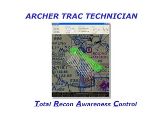
  • 10. ARCHER Hardware Simultaneously with the real-time imagery processing, ARCHER plots the ground area swept by the sensors on a handheld tablet PC designated ARCHER TRAC. ARCHER TRAC is a mission navigation and tracking tool that helps the crew ensure that imagery data is collected from the entire search area. Key waypoints are easily programmed into ARCHER TRAC. The ground area that is covered by the ARCHER sensors is superimposed on a standard aviation sectional map.
  • 12.
  • 13.
  • 14.
  • 15. Illumination Requirements Illumination Guideline If you can clearly see objects on the ground, then there is enough light for ARCHER.
  • 16.
  • 17. ARCHER TRAC Tablet PC-based real-time mission navigation aid
  • 18.
  • 19.
  • 20.
  • 21.
  • 22.
  • 23.
  • 24.  

Editor's Notes

  1. Mention that in certain urgent situations, as decided by the IC of the mission, in cooperation with the Archer Operator, the Archer Trac Technician can data collect independent of the Archer Operator. Also verbally review OPSEC, non-disclosure, and CONEMP.
  2. You can load it but it still belongs to CAP.
  3. Point out the major components and describe their function.
  4. Pixel width is determined by the altitude. At a flight altitude of 2,500 ft, each pixel in the HSI camera CCD represents a ground swath width of 1.04 meters. At a flight altitude of 5,000 ft AGL, the corresponding ground width is 2.08 meters.
  5. Must be calibrated to ac true heading and position.
  6. Best if flown at 12N, bright and sunny, but can be used in other illumination conditions.
  7. Mention that mission planning must take into account the start time of the mission and its planned duration. For example, it is inappropriate to start a January mission at 4 p.m. that requires 90 minutes to reach the search area. By the time the aircraft reaches the search area, there will not be sufficient ground illumination for ARCHER to function.
  8. A regular lap top may be used.
  9. Seminar/class participation needed in stating the objectives.