1. TÊN HỌC PHẦN: ĐỊA CHẤT VIỆT NAM
Mã học phần: DCH2112
Tài liệu tham khảo học tập - nghiên cứu
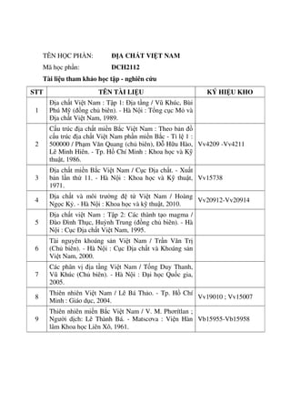
STT TÊN TÀI LIỆU KÝ HIỆU KHO
1
Địa chất Việt Nam : Tập 1: Địa tầng / Vũ Khúc, Bùi
Phú Mỹ (đồng chủ biên). - Hà Nội : Tổng cục Mỏ và
Địa chất Việt Nam, 1989.
2
Cấu trúc địa chất miền Bắc Việt Nam : Theo bản đồ
cấu trúc địa chất Việt Nam phần miền Bắc - Tỉ lệ 1 :
500000 / Phạm Văn Quang (chủ biên), Đỗ Hữu Hào,
Lê Minh Hiên. - Tp. Hồ Chí Minh : Khoa học và Kỹ
thuật, 1986.
Vv4209 -Vv4211
3
Địa chất miền Bắc Việt Nam / Cục Địa chất. - Xuất
bản lần thứ 11. - Hà Nội : Khoa học và Kỹ thuật,
1971.
Vv15738
4
Địa chất và môi trường đệ tứ Việt Nam / Hoàng
Ngọc Kỷ. - Hà Nội : Khoa học và kỹ thuật, 2010.
Vv20912-Vv20914
5
Địa chất việt Nam : Tập 2: Các thành tạo magma /
Đào Đình Thục, Huỳnh Trung (đồng chủ biên). - Hà
Nội : Cục Địa chất Việt Nam, 1995.
6
Tài nguyên khoáng sản Việt Nam / Trần Văn Trị
(Chủ biên). - Hà Nội : Cục Địa chất và Khoáng sản
Việt Nam, 2000.
7
Các phân vị địa tầng Việt Nam / Tống Duy Thanh,
Vũ Khúc (Chủ biên). - Hà Nội : Đại học Quốc gia,
2005.
8
Thiên nhiên Việt Nam / Lê Bá Thảo. - Tp. Hồ Chí
Minh : Giáo dục, 2004.
Vv19010 ; Vv15007
9
Thiên nhiên miền Bắc Việt Nam / V. M. Phơrítlan ;
Người dịch: Lê Thành Bá. - Matscơva : Viện Hàn
lâm Khoa học Liên Xô, 1961.
Vb15955-Vb15958
2. so GrAo DUC vA DAo r4,o
rIA NQr
xi, rHI ruvtN smn lop to rHPT
NAn HOc 2or9 -zo2o
oAp AN - rHlNc oIf,*l
Biri thi : XCIIVAN
(Edp an - thang ctidm gim cd 0l trang)
(.,
^
sa G 0 DUC
Di6mCAu
__VI-_*"T.rf,I
NQi dungPhin
I
0,5
0,5
HS;ffi%,
- Th€ tho : ndm cht ;
- T€n hai t6c phAm khric trong chuong trinh Ngt vin 9 cing dugc vi6t theo th6 tho ndm chfr
I
0,s
I,O2
- Chi ra duo. c citc giirc quan : khr?u gi6c, xirc gi6c, thi gi6c ;
- Cric tt "b6ng",;hinh nhu" thii nien tam Eang ngd nging @At ngd, ngac nhi6n,...),
cim xfc bAng khudng (phAn vdn, bin kho[n,...) cta tric gii.
0,5
0,5
Phdn tich ilugc hiQu qud nghQ thuit cta ph6p nhdn h6a :
- Cqi hinh dnh suong c6 :i chim l3i, chuydn dQng nhg nhing. ... I
- Gqi tdm trang luu luydn (vuong vAn, bln rin,.. .1 : su tinh tC vi tinh y6u thi6n nhi6n cita
la.tiic
J
t,0
1,0
- N6i aung : Bii5t b6m s5t ngfr liQu vd khai th6c hiQu quri c6c tin.hiQu nghQ thuat (tu ngir,
hinh dnh, biQn phtip tu tu,...t lam sring t6 nhtng cdm nhin tinh t6 vd sdu sic cta tric gii :
+ Vd thi6n nhi6n, det troi ;
..: -..+ ve ool nguor.
0,5
0,5
0,5
- Hinh thuc :
+ Dim bdo dung lugng, c6 rinh tu mph lac, di6n <Iat 16 f ; 1$6ng mic l6i chinn A, ngu
phip I
+ Dring doan vIn theo ph6p ldp luin t6ng hqp - phdn tich - t6ng hqp ;
+ Su dung dring vd gach duoi m6t ciu bi dOng, mOt thenh phnn cim thrin.
II
0,25
0,25
I
Xrlc clinh thing : .
- MQt ph6p li6n k6t;
- Tt ngt ldm phuong tien li€n k6t.
0,25
0,25
Chi * duqc c,i.
"eJh
unfiir md t6c gia dd cip d6n trong tlo4n trich :
- "Bi quan, th6t vgng, ch6n nin, th6i chi" ;
- "G6ng minh lrrot qua".
0,5
0,75
0,25
- Nqi dung
+ Hi6u duo. c nQi dung cua f kii5n (uai to, i ngtria cta hoan canh kh6 khen d6i voi viQc
khriLm ph6 khi.ndng cria bin than m6i nguoi) vd bdy td chinh ki6n cia c6 nhAn
(d6ng !/ kh6ng d6ng j' . . .) ;
+ Ban luin x6c dang, thuydt phr,rc vO nQi dung f.ki6n theo quan tli6m cua c6 nhAn ;
+ C6 nhirng li6n hd vi rut ra bii hQc can thi6t.
3
- Hinh thric : Dim bio dung luqng, c6 trinh tu mSch l4c, lflp luan chdt chE. di6n dat rd
v,...
10,0TONGDIEM:
Hi!t
2
&.x- --/p:/
4
2
0,5
4. Matjaž Mikoš • Željko Arbanas
Yueping Yin • Kyoji Sassa
Editors
Advancing Culture of Living
with Landslides
Volume 3 Advances in Landslide Technology
123
6. Foreword By Irina Bokova
Every year, disasters induced by natural hazards affect millions of people across the world.
The loss of life is tragic, impacting on communities for the long term.
The costs are also economic, as disasters are responsible for estimated annual economic
losses of around USD 300 billion. With the rising pressures of climate change, overpopulation,
and urbanization, we can expect costs to increase ever more.
We cannot prevent disasters but we can prepare for them better. This is the importance
of the International Consortium on Landslides, supported actively by UNESCO, to advance
research and build capacities for mitigating the risks of landslides. Led by Prof. Kyoji Sassa,
the Consortium has become a success story of international scientific cooperation at a time
when this has never been so vital.
This is especially important as the world implements the 2030 Agenda for Sustainable
Development and the Paris Agreement on Climate Change, as well as the Sendai Framework
for Disaster Risk Reduction 2015–2030—adopted in Sendai, Japan, to assess global progress
on disaster risk reduction and set the priority actions.
The International Strategy for Disaster Risk Reduction—International Consortium on
Landslides Sendai Partnerships 2015–2025 is the key outcome relating to landslides from the
3rd World Conference on Disaster Risk Reduction, held in Sendai. On this basis, every
member of the International Consortium of Landslides is redoubling efforts to understand,
foresee, and reduce landslide disaster risk across the world.
Led by the Consortium, the Landslide Forum is a triennial milestone event that brings
together scientists, engineers, practitioners, and policy makers from across the world—all
working in the area of landslide technology, landslide disaster investigation, and landslide
remediation. Meeting in Slovenia, the 4th Landslide Forum will explore the theme, “Landslide
Research and Risk Reduction for Advancing Culture of Living with Natural Hazards”,
focusing on the multidisciplinary implementation of the Sendai Framework to build a global
culture of resilient communities.
Against this backdrop, this report includes state-of-the-art research on landslides, inte-
grating knowledge on multiple aspects of such hazards and highlighting good practices and
recommendations on reducing risks. Today, more than ever, we need sharper research and
v
7. stronger scientific cooperation. In this spirit, I thank all of the contributors to this publication
and I pledge UNESCO’s continuing support to deepening partnerships for innovation and
resilience in societies across the world.
January 2017 Irina Bokova
Director General of UNESCO
vi Foreword By Irina Bokova
8. Foreword By Robert Glasser
Landslides are a serious geological hazard. Among the host of natural triggers are intense
rainfall, flooding, earthquakes or volcanic eruption, and coastal erosion caused by storms that
are all too often tied to the El Niño phenomenon. Human triggers including deforestation,
irrigation or pipe leakage, and mining spoil piles, or stream and ocean current alteration can
also spark landslides.
Landslides occur worldwide but certain regions are particularly susceptible. The UN’s Food
and Agriculture Organization underlines that steep terrain, vulnerable soils, heavy rainfall, and
earthquake activity make large parts of Asia highly susceptible to landslides. Other hotspots
include Central, South, and Northwestern America.
Landslides have devastating impact. They can generate tsunamis, for example. They can
bring high economic costs, although estimating losses is difficult, particularly so when it
comes to indirect losses. The latter are often confused with losses due to earthquakes or
flooding.
Globally, landslides cause hundreds of billions of dollars in damages and hundreds of
thousands of deaths and injuries each year. In the US alone, it has been estimated that
landslides cause in excess of US$1 billion in damages on average per year, though that is
considered a conservative figure and the real level could be at least double.
Given this, it is important to understand the science of landslides: why they occur, what
factors trigger them, the geology associated with them, and where they are likely to happen.
Geological investigations, good engineering practices, and effective enforcement of land
use management regulations can reduce landslide hazards. Early warning systems can also be
very effective, with the integration between ground-based and satellite data in landslide
mapping essential to identify landslide-prone areas.
Given that human activities can be a contributing factor in causing landslides, there are a
host of measures that can help to reduce risks, and losses if they do occur. Methods to avoid or
mitigate landslides range from better building codes and standards in engineering of new
construction and infrastructure, to better land use and proper planned alteration of drainage
patterns, as well as tackling lingering risks on old landslide sites.
Understanding the interrelationships between earth surface processes, ecological systems,
and human activities is the key to reducing landslides disaster risks.
The Sendai Framework for Disaster Risk Reduction, a 15-year international agreement
adopted in March 2015, calls for more dedicated action on tackling underlying disaster risk
drivers. It points to factors such as the consequences of poverty and inequality, climate change
and variability, unplanned and rapid urbanization, poor land management, and compounding
factors such as demographic change, weak institutional arrangements, and non-risk-informed
policies. It also flags a lack of regulation and incentives for private disaster risk reduction
investment, complex supply chains, limited availability of technology, and unsustainable uses
of natural resources, declining ecosystems, pandemics and epidemics.
The Sendai Framework also calls for better risk-informed sectoral laws and regulations,
including those addressing land use and urban planning, building codes, environmental and
vii
9. resource management and health and safety standards, and underlines that they should be
updated, where needed, to ensure an adequate focus on disaster risk management.
The UN Office for Disaster Risk Reduction (UNISDR) has an important role in reinforcing
a culture of prevention and preparedness in relevant stakeholders. This is done by supporting
the development of standards by experts and technical organizations, advocacy initiatives, and
the dissemination of disaster risk information, policies, and practices. UNISDR also provides
education and training on disaster risk reduction through affiliated organizations, and supports
countries, including through national platforms for disaster risk reduction or their equivalent,
in the development of national plans and monitoring trends and patterns in disaster risk, loss,
and impacts.
The International Consortium on Landslides (ICL) hosts the Sendai Partnerships 2015–
2025 for the global promotion of understanding and reducing landslide disaster risk. This is
part of 2015–2025, a voluntary commitment made at the Third UN World Conference on
Disaster Risk Reduction, held in 2015 in Sendai, Japan, where the international community
adopted the Sendai Framework.
The Sendai Partnerships will help to provide practical solutions and tools, education and
capacity building, and communication and public outreach to reduce landslides risks. As such,
they will contribute to the implementation of the goals and targets of the Sendai Framework,
particularly on understanding disaster risks including vulnerability and exposure to integrated
landslide-tsunami risk.
The work done by the Sendai Partnerships can be of value to many stakeholders including
civil protection, planning, development and transportation authorities, utility managers, agri-
cultural and forest agencies, and the scientific community.
UNISDR fully support the work of the Sendai Partnerships and the community of practice
on landslides risks, and welcomes the 4th World Landslide Forum to be held in 2017 in
Slovenia, which aims to strengthen intergovernmental networks and the international pro-
gramme on landslides.
Robert Glasser
Special Representative of the Secretary-General
for Disaster Risk Reduction and head of UNISDR
viii Foreword By Robert Glasser
10. Preface
Rapid development of modern technologies in last decades had a significant influence on
development of technologies used in landslide investigation, monitoring, simulation, reme-
diation and mitigation all in order to mutually reduce landslide disaster hazard and risk.
Development of modern technologies heavily influenced on all parts of landslide researches
represented in this Volume: Landslide Monitoring and Warning: Monitoring Techniques and
Technologies, and Early Warning Systems; Landslide Disasters and Relief: Case Studies,
Emergency Measures, First Aid, and Civil Protection Measures and Landslide Mitigation,
Remediation and Stabilization: Landslide Protection Works, Landslide Stabilization and
Remediation, and Landslide Non-structural Measures.
Landslides are by definition characterized by movement (Cruden 1991). Knowledge of the
movement magnitude and velocity, that is, movement distribution along the slope, are the
most important data for all landslide analysis. Monitoring is required to observe the changing
conditions that may lead to total failure of the slope where slope movement is occurring, where
safety factors against sliding are low, or where high risk is present fromof the ISDR-ICL
Sendai a possible slope failure. Landslide movement monitoring expressed via ground surface
displacements and deformation of structures (including the landslide body) related to land-
slides can be accomplished using different types of monitoring systems and techniques
(Mihalić Arbanas and Arbanas 2016). Monitoring techniques are classified according to
Savvaidis (2003) as follows: satellite and remote sensing techniques, photogrammetric tech-
niques, geodetic or observational techniques, and geotechnical or instrumentation or physical
techniques. Except conventional ground-based geodetic techniques used for surface dis-
placement monitoring of landslides and geotechnical sensors used to ensure efficient data for
landslide behavior prediction and landslide stability analysis (inclinometers, extensometers,
crack meters, piezometers, deformeters, tiltmeters, klinometers, load and pressure cells, and
geophones), all other monitoring techniques, especially satellite and remote sensing techniques
(photography and imagery ranging from ground-based mobile units to airborne or satellite
platforms using LiDAR, optical, and radar sensors) are based on new technologies developed
in last 25 years (Delacourt et al. 2007, Casagli et al., 2010, Corsini et al., 2006; Jaboyedoff
et al. 2012; Abellan et al. 2014, Casagli et al. 2017). Modern technologies development
significantly influenced on further improvement geodetic or observational techniques by
introduction of Global Positioning System (GPS) (Gili et al. 2000) and other satellite-related
positioning systems as well as technological improving of conventional geodetical and
geotechnical equipment and possibility for connection of monitoring equipment in rapid
wireless network. Usually, different types of monitoring techniques and instrumentation are
used in different combinations and connected in a unique comprehensive landslide monitoring
system and because of the variability in landslide types and processes, targets of landslide
investigation, field conditions, and ongoing technological development of monitoring sensors,
no standardization can be adopted as a universal solution for landslide monitoring system
setups (Mihalić Arbanas and Arbanas 2016).
In some situations where the volume of a landslide are too large to enable effective
landslide remediation or the countermeasures are too expensive, other types of mitigations
ix
11. have to be performed in order to decrease the landslide risk (Michoud et al. 2013). Appropriate
and prompt mitigation measures should reduce the number of people exposed to the risk by
establishing an adequate and reliable early warning systems that are able and competent to
define alarm conditions and alert endangered populations in time based on monitoring results
from the observed landslide. Early warning systems are defined by the United Nations as “the
set of capacities needed to generate and disseminate timely and meaningful warning infor-
mation to enable individuals, communities and organizations threatened by a hazard to prepare
and to act appropriately and in sufficient time to reduce the possibility of harm or loss”
(UN-ISDR 2009). Effective landslide early warning systems should hold four major elements
integrated in one unique system: (1) risk assessment, (2) phenomenon monitoring and fore-
casting, (3) warning communication and alert dissemination, and (4) local response aptitudes
(UN-ISDR 2009). Similarly as for a landslide monitoring system, no standardization can be
adopted as a universal solution for landslide early warning system establishment.
Despite the significant advancement in landslides science, technology and landslide risk
preparedness, the occurrences of landslide disaster are still numerous, unexpected and deadly
in different reliefs and geological conditions over the world. Activities related to landslide
post-disaster emergency measures are very important for reduction of final number of landslide
victims and depend on well preparedness of first aid and civil protection organization as well
as preparedness and self-organization of local community.
The purpose of landslide stabilization and remediation measures is to ensure permanent
stability of the slope against current and reasonably possible conditions in the slope (Cornforth
2005). Landslide stabilization methods and remediation measures can be established following
two general principles in soil stabilization: reducing the active forces that caused the landslide
or increasing the soil or rock resistance (strength). However, there is no general recipe for
landslide remediation, and an original stabilization approach should be accepted for each
landslide (Hutchinson 1977). Terzaghi (1951) has underlined that ‘if a slope has started to
move, the means for stopping movement must be adapted to the processes which started the
slide’. The successful application of each performed measure depends on correct recognition
during the investigation of the specific soil and groundwater conditions in the field and
application in the remediation design (Popescu 2001) and each landslide stabilization design
should be an original consideration about landslide geometry, active forces, soil or rock
strength, and their development in time.
This WLF4 Volume 3: Advances in Landslide Technology collected results of recent
researches related to the topics Landslide Monitoring and Warning; Landslide Disasters and
Relief and Landslide Mitigation, Remediation and Stabilization that make the main Sessions
of this Volume. The Volume 3 Advances in Landslide Technology includes 67 research papers
from 28 countries (Austria, Belgium, Bosnia and Herzegovina, Bulgaria, Canada, China,
Chinese Taipei, Croatia, Czech Republic, France, Germany, Hungary, Indonesia, India, Italy,
Japan, Korea, Mexico, New Zealand, Norway, Poland, Serbia, Slovenia, Spain, Switzerland,
Turkey, Uganda and Ukraine): one Keynote Lecture; 41 research papers in Session Landslide
Monitoring and Warning: Monitoring Techniques and Technologies, and Early Warning
Systems; 6 research papers in Session Landslide Disasters and Relief: Case Studies, Emer-
gency Measures, First Aid, and Civil Protection Measures; 19 research papers in Session
Landslide Mitigation, Remediation and Stabilization: Landslide Protection Works, Landslide
Stabilization and Remediation, and Landslide Non-structural Measures; as well as adequate
Session Introductions.
The editors of the WLF4 Volume 3 Advances in Landslide Technology would like to thank
all authors who have contributed their research results, the associate editors who have leading
the review processes and the reviewers who have reviewed the papers submitted to this
Volume.
x Preface
12. References
Abellán A, Oppikofer T, Jaboyedoff M, Rosser NJ, Lim M, Lato, MJ (2014) Terrestrial laser scanning of rock
slope instabilities. Earth Surface Processes and Landforms 39(1):80–97
Casagli N, Catani F, Del Ventisette C, Luzi G (2010) Monitoring, prediction, and early warning using
ground-based radar interferometry. Landslides 7(3):291–301
Casagli N, Tofani V, Morelli S, Frodella W, Ciampalini A, Raspini R, Intrieri E (2017) Remote sensing
techniques in landslide mapping and monitoring. In: Mikoš M, Arbanas Ž , Yin Y, Sassa K (eds) Advancing
culture of living with landslides, vol 3. Springer International Publishing Switzerland (this volume)
Cornforth DH (2005) Landslides in practice. Investigation, analysis and remedial/preventive options in soils.
John Wiley & Sons Inc, Hoboken, New Jersey
Corsini A, Farina P, Antonello G, Barbieri M, Casagli N, Coren F, Guerri L, Ronchetti F, Sterzai P, Tarchi D
(2006) Space-borne and ground-based SAR interferometry as tools for landslide hazard management in
civil protection. International Journal of Remote Sensing 27(12):2351–2369
Cruden DM (1991). A simple definition of a landslide. Bulletin of Engineering Geology and the Environment
43:27–29
Delacourt C, Allemand P, Berthier E, Raucoules D, Casson B, Grandjean P et al. (2007) Remote-sensing
techniques for analyzing landslide kinematics: A review. Bulletin de la Société Géologique de France 178
(2):89–100. doi:10.2113/gssgfbull.178.2.89
Gili JA, Corominas J, Rius J (2000) Using Global positioning System techniques in landslide monitoring.
Engineering Geology 55:167–192
Hutchinson JN (1977) The assessment of the effectiveness of corrective measures in relation to geological
conditions and types of slope movement. Bulletin of Engineering Geology and the Environment 16(1):
131–155
Jaboyedoff M, Oppikofer T, Abellán A, Derron M-H, Loye A, Metzger R, Pedrazzini A (2012) Use of LIDAR
in landslide investigations: a review. Natural Hazards, 61:5–28
Michoud C, Bazin S, Blikra LH, Derron MH, Jaboyedoff M (2013) Experiences from site-specific landslide
early warning systems. Natural Hazards and Earth System Sciences 13:2659–2673
Mihalić Arbanas S, Arbanas Ž (2015) Landslides—A guide to researching landslide phenomena and processes.
In Gaurina-Međimurac N (ed) Handbook of research on advancements in environmental engineering. IGI
Global, Hershey, pp 474–510
Popescu ME (2001). A suggested method for reporting landslide remedial measures. Bulletin of Engineering
Geology and the Environment 60(1):69–74
Savvaidis PD (2003). Existing landslide monitoring systems and techniques. In Proceedings of the conference
from stars to earth and culture, In honor of the memory of Professor Alexandros Tsioumis, The Aristotle
University of Thessaloniki. Thessaloniki, Greece, pp 242–258
Terzaghi K (1951) Mechanisms of landslides. Harvard University: Los Angeles, CA
UN-ISDR (2009) Terminology on disaster risk reduction, United Nation International Strategy for Disaster
Reduction, Geneva, Switzerland, 35 p.
Ljubljana, Slovenia Matjaž Mikoš
Rijeka, Croatia Željko Arbanas
Beijing, China Yueping Yin
Kyoto, Japan Kyoji Sassa
Preface xi
13. Organizers
International Consortium on Landslides (ICL)
International Programme on Landslides (IPL)
University of Ljubljana
Geological Survey of Slovenia (GeoZS)
xiii
14. Co-organizers
Republic of Slovenia Ministry of the Environment and Spatial Planning
Republic of Slovenia Ministry of Infrastructure
Slovenian National Platform for Disaster Risk Reduction
Slovenian Chamber of Engineers (IZS)
• Društvo Slovenski komite mednarodnega združenja hidrogeologov (SKIAH)—International
Association of Hydrogeologists Slovene Committee (SKIAH)
• Društvo vodarjev Slovenije (DVS)—Water Management Society of Slovenia (DVS)
• Geomorfološko društvo Slovenije (GDS)—Geomorphological Association of Slovenia
(GDS)
• Inštitut za vode Republike Slovenije (IzVRS)—Institute of Water of the Republic of
Slovenia (IzVRS)
• Slovensko geološko društvo (SGD)—Slovenian Geological Society (SGD)
• Slovensko geotehniško društvo (SloGeD)—Slovenian Geotechnical Society (SloGeD)
• Slovenski nacionalni odbor programa IHP UNESCO (SNC IHP)—Slovenian National
Committee for IHP (SNC IHP)
• Slovensko združenje za geodezijo in geofiziko (SZGG)—Slovenian Association of
Geodesy and Geophysics (SZGG)
xiv Organizers
15. Organizing Committee
Honorary Chairpersons
Borut Pahor, President of the Republic of Slovenia*
Irina Bokova, Director General of UNESCO
Robert Glasser, Special Representative of the United Nations Secretary-General for Disaster
Risk Reduction*
José Graziano Da Silva, Director General of FAO*
Petteri Talaas, Secretary General of WMO
David Malone, Rector of UNU
Gordon McBean, President of ICSU
Toshimitsu Komatsu, Vice President of WFEO
Roland Oberhaensli, President of IUGS
Alik Ismail-Zadeh, Secretary General of IUGG
Hisayoshi Kato, Director General for Disaster Management, Cabinet Office, Government of
Japan
Kanji Matsumuro, Director, Office for Disaster Reduction Research, Ministry of Education,
Culture, Sports, Science and Technology, Government of Japan
Fabrizio Curcio, Head, National Civil Protection Department, Italian Presidency of the
Council of Ministers, Government of Italy
Jadran Perinić, Director General, National Protection and Research Directorate, Republic of
Croatia
Takashi Onishi, President of Science Council of Japan
Juichi Yamagiwa, President of Kyoto University
Ivan Svetlik, Rector of University of Ljubljana, Slovenia
Walter Ammann, President/CEO, Global Risk Forum Davos
Note: Honorary chairpersons are Leaders of signatory organizations of the ISDR-ICL Sendai
Partnerships. * to be confirmed.
Chairpersons
Matjaž Mikoš, Chairman, Slovenian National Platform for Disaster Risk Reduction
Yueping Yin, President, International Consortium on Landslides
Kyoji Sassa, Executive Director, International Consortium on Landslides
International Scientific Committee
Che Hassandi Abdulah, Public Works Department of Malaysia, Malaysia
Biljana Abolmasov, University of Belgrade, Serbia
Basanta Raj Adhikari, Tribhuvan University, Nepal
Beena Ajmera, California State University, Fullerton, USA
Irasema Alcántara Ayala, Universidad Nacional Autonoma de Mexico, Mexico
Guillermo Avila Alvarez, Universidad Nacional de Colombia, Colombia
Željko Arbanas, University of Rijeka, Croatia
Behzad Ataie-Ashtiani Sharif, University of Technology, Iran
Mateja Jemec Auflič, Geological Survey of Slovenia, Slovenia
Yong Baek, Korea Institute of Civil Engineering and Building Technology, Korea
Lidia Elizabeth Torres Bernhard, Universidad Nacional Autónoma de Honduras, Honduras
Matteo Berti, University of Bologna, Italy
Netra Prakash Bhandary, Ehime University, Japan
He Bin, Chinese Academy of Sciences, China
Organizers xv
16. Peter Bobrowsky, Geological Survey of Canada, Canada
Giovanna Capparelli, University of Calabria, Italy
Raul Carreno, Grudec Ayar, Peru
Nicola Casagli, University of Florence, Italy
Filippo Catani, University of Florence, Italy
Byung-Gon Chae, Korea Institute of Geoscience and Mineral Resources, Korea
Buhm-Soo Chang, Korea Infrastructure Safety and Technology Corporation, Korea
Giovanni Battista Crosta, University of Milano Bicocca, Italy
Sabatino Cuomo, University of Salerno, Italy
A.A. Virajh Dias, Central Engineering Consultancy Bureau, Sri Lanka
Tom Dijkstra, British Geological Survey, UK
Francisco Dourado, University of Rio de Janeiro State, Brasil
Erik Eberhardt, University of British Columbia, Canada
Luis Eveline, Universidad Politécnica de Ingeniería, Honduras
Teuku Faisal Fathani, University of Gadjah Mada, Indonesia
Paolo Frattini, University of Milano Bicocca, Italy
Hiroshi Fukuoka, Niigata University, Japan
Rok Gašparič, Ecetera, Slovenia
Ying Guo, Northeast Forestry University, China
Fausto Guzzetti, National Research Council, Italy
Javier Hervas, ISPRA, Italy/EU
Daisuke Higaki, Japan Landslide Society, Japan
Arne Hodalič, National Geographic Slovenija, Slovenia
Jan Hradecký, University of Ostrava, Czech Republic
Johannes Hübl, University of Natural Resources and Life Sciences, Austria
Oldrich Hungr, University of British Columbia, Canada
Sangjun Im, Korean Society of Forest Engineering, Korea
Michael Jaboyedoff, University of Lausanne, Switzerland
Jernej Jež, Geological Survey of Slovenia, Slovenia
Pavle Kalinić, City of Zagreb, Croatia
Bjørn Kalsnes, Norwegian Geotechnical Institute, Norway
Dwikorita Karnawati, University of Gadjah Mada, Indonesia
Asiri Karunawardana, National Building Research Organization, Sri Lanka
Ralf Katzenbach, Technische Universitaet Darmstadt, Germany
Nguyen Xuan Khang, Institute of Transport Science and Technology, Vietnam
Kyongha Kim, National Institute of Forest Science, Korea
Dalia Kirschbaum, NASA Goddard Space Flight Center, USA
Jan Klimeš, Academy of Sciences of the Czech Republic, Czech Republic
Marko Komac, University of Ljubljana, Slovenia
Kazuo Konagai, University of Tokyo, Japan
Hasan Kulici, Albanian Geological Survey, Albania
Santosh Kumar, National Institute of Disaster Management, India
Simon Loew, ETH Zürich, Switzerland
Jean-Philippe Malet, Université de Strasbourg, France
Claudio Margottini, ISPRA, Italy
Snježana Mihalić Arbanas, University of Zagreb, Croatia
Gabriele Scarascia Mugnozza, University of Rome “La Sapienza”, Italy
Chyi-Tyi Lee, National Central University, Chinese Taipei
Liang-Jeng Leu, National Taiwan University, Chinese Taipei
Ko-Fei Liu, National Taiwan University, Chinese Taipei
Janko Logar, University of Ljubljana, Slovenia
Ping Lu, Tongji University, China
Juan Carlos Loaiza, Colombia
Mauri McSaveney, GNS Science, New Zealand
Matjaž Mikoš, University of Ljubljana, Slovenia
xvi Organizers
17. Ashaari Mohamad, Public Works Department of Malaysia, Malaysia
Hirotaka Ochiai, Forest and Forest Product Research Institute, Japan
Igwe Ogbonnaya, University of Nigeria, Nigeria
Tomáš Pánek, University of Ostrava, Czech Republic
Mario Parise, National Research Council, Italy
Hyuck-Jin Park, Sejong University, Korea
Cui Peng, Chinese Academy of Sciences, China
Luciano Picarelli, Second University of Naples, Italy
Tomislav Popit, University of Ljubljana, Slovenia
Saowanee Prachansri, Ministry of Agriculture and Cooperatives, Thailand
Boštjan Pulko, University of Ljubljana, Slovenia
Paulus P. Rahardjo Parahyangan Catholic University, Indonesia
Bichit Rattakul Asian Disaster Preparedness Center, Thailand
K.L.S. Sahabandu, Central Engineering Consultancy Bureau, Sri Lanka
Kyoji Sassa, International Consortium on Landslides, Japan
Wei Shan, Northeast Forestry University, China
Z. Shoaei, Soil Conservation and Watershed Management Research Institute, Iran
Mandira Shrestha, International Centre for Integrated Mountain Development, Nepal
Paolo Simonini, University of Padua, Italy
Josef Stemberk, Academy of Sciences of the Czech Republic, Czech Republic
Alexander Strom, JSC “Hydroproject Institute”, Russian Federation
S.H. Tabatabaei, Building & Housing Research Center, Iran
Kaoru Takara, Kyoto University, Japan
Dangsheng Tian, Bureau of Land and Resources of Xi’an, China
Binod Tiwari, California State University, Fullerton & Tribhuvan University, USA
Veronica Tofani, University of Florence, Italy
Adrin Tohari, Indonesian Institute of Sciences, Indonesia
Oleksandr M. Trofymchuk, Institute of Telecommunication and Global Information Space,
Ukraine
Emil Tsereteli, National Environmental Agency of Georgia, Georgia
Taro Uchimura, University of Tokyo, Japan
Tran Tan Van, Vietnam Institute of Geosciences and Mineral Resources, Vietnam
Timotej Verbovšek, University of Ljubljana, Slovenia
Pasquale Versace, University of Calabria, Italy
Vít Vilímek, Charles University, Czech Republic
Ján Vlčko, Comenius University, Slovak Republic
Kaixi Xue, East China University of Technology, China
Yueping Yin, China Geological Survey, China
Akihiko Wakai, Japan Landslide Society, Japan
Fawu Wang, Shimane University, Japan
Gonghui Wang, Kyoto University, Japan
Huabin Wang, Huazhong University of Science and Technology, China
Janusz Wasowski, National Research Council, Italy
Patrick Wassmer, Université Paris 1, France
Mike Winter, Transport Research Laboratory, UK
Sabid Zekan, University of Tuzla, Bosnia and Herzegovina
Oleg Zerkal, Moscow State University, Russian Federation
Ye-Ming Zhang, China Geological Survey, China
Local Organizing Committee
Biljana Abolmasov, Faculty of Mining and Geology, University of Belgrade, Serbia
Željko Arbanas, Faculty of Civil Engineering, University of Rijeka, Croatia
Miloš Bavec, Geological Survey of Slovenia
Organizers xvii
18. Nejc Bezak, Faculty of Civil and Geodetic Engineering, University of Ljubljana
Mitja Brilly, Slovenian National Committee for IHP
Darko But, Administration for Civil Protection and Disaster Relief, Ministry of Defence of the
Republic of Slovenia
Lidija Globevnik, Water Management Society of Slovenia
Arne Hodalič, National Geographic Slovenia
Mateja Jemec Auflič, Geological Survey of Slovenia
Jernej Jež, Geological Survey of Slovenia
Vojkan Jovičić, Slovenian Geotechnical Society
Robert Klinc, Faculty of Civil and Geodetic Engineering, University of Ljubljana
Janko Logar, Faculty of Civil and Geodetic Engineering, University of Ljubljana
Matej Maček, Faculty of Civil and Geodetic Engineering, University of Ljubljana
Snježana Mihalić Arbanas, Faculty of Mining, Geology and Petroleum Engineering,
University of Zagreb, Croatia
Matjaž Mikoš, Faculty of Civil and Geodetic Engineering, University of Ljubljana
Zlatko Mikulič, International Association of Hydrogeologists Slovene Committee
Gašper Mrak, Faculty of Civil and Geodetic Engineering, University of Ljubljana
Mario Panizza, University of Modena and Reggio Emilia, Italy
Alessandro Pasuto, National Research Council, Padua, Italy
Ana Petkovšek, Faculty of Civil and Geodetic Engineering, University of Ljubljana
Tomislav Popit, Faculty of Natural Sciences and Engineering, University of Ljubljana
Boštjan Pulko, Faculty of Civil and Geodetic Engineering, University of Ljubljana
Jože Rakovec, Slovenian Association of Geodesy and Geophysics
Črtomir Remec, Slovenian Chamber of Engineers
Mauro Soldati, University of Modena and Reggio Emilia, Italy
Timotej Verbovšek, Faculty of Natural Sciences and Engineering, University of Ljubljana
Sabid Zekan, Faculty of Mining, Geology and Civil Engineering, University of Tuzla, Bosnia
and Herzegovina
xviii Organizers
19. Contents
Remote Sensing Techniques in Landslide Mapping and Monitoring,
Keynote Lecture . . . . . . . . . . . . . . . . . . . . . . . . . . . . . . . . . . . . . . . . . . . . . . . . . . . . . 1
Nicola Casagli, Veronica Tofani, Stefano Morelli, William Frodella,
Andrea Ciampalini, Federico Raspini, and Emanuele Intrieri
Part I Landslide Monitoring and Warning
Introduction: Landslide Monitoring and Warning . . . . . . . . . . . . . . . . . . . . . . . . . . 23
Željko Arbanas and Veronica Tofani
Multisensor Landslide Monitoring as a Challenge for Early Warning:
From Process Based to Statistic Based Approaches . . . . . . . . . . . . . . . . . . . . . . . . . 33
Francesca Bozzano, Carlo Esposito, Andrea Fantini, Matteo Fiorucci,
Salvatore Martino, Paolo Mazzanti, Alberto Prestininzi, Stefano Rivellino,
Alfredo Rocca, and Gabriele Scarascia Mugnozza
Wireless Sensor Networks for Early Warning of Landslides:
Experiences from a Decade Long Deployment . . . . . . . . . . . . . . . . . . . . . . . . . . . . . 41
Maneesha Vinodini Ramesh, Divya Pullarkatt, T.H. Geethu, and P. Venkat Rangan
Design and Validation of Wireless Communication Architecture
for Long Term Monitoring of Landslides . . . . . . . . . . . . . . . . . . . . . . . . . . . . . . . . . 51
Sangeeth Kumar, P. Venkat Rangan, and Maneesha Vinodini Ramesh
Scalable, Secure, Fail Safe, and High Performance Architecture for Storage,
Analysis, and Alerts in a Multi-site Landslide Monitoring System . . . . . . . . . . . . . 61
Ramesh Guntha, Sangeeth Kumar, and Balaji Hariharan
A Self-adaptive Data Acquisition Technique and Its Application
in Landslide Monitoring . . . . . . . . . . . . . . . . . . . . . . . . . . . . . . . . . . . . . . . . . . . . . . . 71
Xing Zhu, Qiang Xu, Xing Qi, and Hanxiang Liu
A New Landslide Early Warning Technology—Escorting for Life . . . . . . . . . . . . . 79
Hui Yu, Nianzhi Yu, Yan Wang, Lei Yu, and Zhengsheng Yu
Prediction of Displacement Rates at an Active Landslide Using Joint
Inversion of Multiple Time Series . . . . . . . . . . . . . . . . . . . . . . . . . . . . . . . . . . . . . . . 85
Clara Lévy, Scarlett Gendrey, Séverine Bernardie, Marie-Aurélie Chanut,
Aurélien Vallet, Laurent Dubois, and Jean-Paul Duranthon
Time-Prediction Method of the Onset of a Rainfall-Induced Landslide
Based on the Monitoring of Shear Strain and Pore Pressure . . . . . . . . . . . . . . . . . 93
Katsuo Sasahara
Improvement of Fukuzono’s Model for Time Prediction of an Onset
of a Rainfall-Induced Landslide . . . . . . . . . . . . . . . . . . . . . . . . . . . . . . . . . . . . . . . . . 103
Naoki Iwata, Katsuo Sasahara, and Satoshi Watanabe
xix
20. A Full-Scale Model Test for Predicting Collapse Time Using Displacement
of Slope Surface During Slope Cutting Work . . . . . . . . . . . . . . . . . . . . . . . . . . . . . . 111
Nobutaka Hiraoka, Naotaka Kikkawa, Katsuo Sasahara, Kazuya Itoh,
and Satoshi Tamate
Classification of Microseismic Activity in an Unstable Rock Cliff . . . . . . . . . . . . . . 123
Diego Arosio, Mauro Boccolari, Laura Longoni, Monica Papini, and Luigi Zanzi
Prediction of the Process of a Slowly Moving Loess Landslide
by Electrical Resistivity Tomography . . . . . . . . . . . . . . . . . . . . . . . . . . . . . . . . . . . . 131
Sándor Szalai, Ernő Prácser, Kitti Szokoli, and Ádám Tóth
The Pilot Construction of a Sensor-Based Landslide Early Warning
System for Mitigating Human Damages, Republic of Korea . . . . . . . . . . . . . . . . . . 139
Dongyeob Kim, Changwoo Lee, Choongshik Woo, Junpyo Seo, Minjeong Kang,
and Hyunjung Kwon
An Early Warning System of Unstable Slopes by Multi-point MEMS
Tilting Sensors and Water Contents . . . . . . . . . . . . . . . . . . . . . . . . . . . . . . . . . . . . . 147
Wang Lin, Nishie Shunsaku, Uchimura Taro, Towhata Ikuo, Su Ling,
and Tao Shangning
Early Warning of Long Channel and Post-controlled Debris-Flow
Gully in Southwest China. . . . . . . . . . . . . . . . . . . . . . . . . . . . . . . . . . . . . . . . . . . . . . 155
Jian Huang
How Many Rainfall-Induced Landslides Are Detectable by a Regional
Seismic Monitoring Network? . . . . . . . . . . . . . . . . . . . . . . . . . . . . . . . . . . . . . . . . . . 161
Andrea Manconi, Stefano Luigi Gariano, Velio Coviello, and Fausto Guzzetti
Definition of a Fully Functional EWS Based on Rainfall Thresholds,
the Case of Study of Tuscany Region . . . . . . . . . . . . . . . . . . . . . . . . . . . . . . . . . . . . 169
Ascanio Rosi, Samuele Segoni, Alessandro Battistini, Guglielmo Rossi,
Filippo Catani, and Nicola Casagli
ANN Based Rainfall Prediction—A Tool for Developing a Landslide
Early Warning System . . . . . . . . . . . . . . . . . . . . . . . . . . . . . . . . . . . . . . . . . . . . . . . . 175
S. Renuga Devi, P. Arulmozhivarman, and C. Venkatesh
Regional Landslide Early Warning Systems: Comparison of Warning
Strategies by Means of a Case Study. . . . . . . . . . . . . . . . . . . . . . . . . . . . . . . . . . . . . 183
Gaetano Pecoraro, Luca Piciullo, and Michele Calvello
Hybrid Landslide Warning Model for Rainfall Triggered Shallow
Landslides in Korean Mountain. . . . . . . . . . . . . . . . . . . . . . . . . . . . . . . . . . . . . . . . . 193
Ananta Man Singh Pradhan, Hyo-Sub Kang, and Yun-Tae Kim
Sentinel-1 Data Analysis for Landslide Detection and Mapping:
First Experiences in Italy and Spain . . . . . . . . . . . . . . . . . . . . . . . . . . . . . . . . . . . . . 201
Anna Barra, Oriol Monserrat, Michele Crosetto, María Cuevas-Gonzalez,
Núria Devanthéry, Guido Luzi, and Bruno Crippa
Testing Sentinel-1A Data in Landslide Monitoring: A Case Study
from North-Eastern Italian Pre-Alps . . . . . . . . . . . . . . . . . . . . . . . . . . . . . . . . . . . . . 209
Giulia Tessari, Mario Floris, Vladimiro Achilli, Massimo Fabris, Andrea Menin,
and Michele Monego
xx Contents
21. Innovative Landslide Change Detection Monitoring: Application
of Space-Borne InSAR Techniques in the Thompson River Valley,
British Columbia, Canada . . . . . . . . . . . . . . . . . . . . . . . . . . . . . . . . . . . . . . . . . . . . . 219
David Huntley, Peter Bobrowsky, Francois Charbonneau, Jeffrey Journault,
Renato Macciotta, and Michael Hendry
Remote Sensing Mapping and Monitoring of the Capriglio Landslide
(Parma Province, Northern Italy) . . . . . . . . . . . . . . . . . . . . . . . . . . . . . . . . . . . . . . . 231
Federica Bardi, Federico Raspini, William Frodella, Luca Lombardi,
Massimiliano Nocentini, Giovanni Gigli, Stefano Morelli, Alessandro Corsini,
and Nicola Casagli
Monitoring the Deep-Seated Landslides by Using ALOS/PALSAR
Satellite Imagery in the Disaster Area of 2009 Typhoon Morakot, Taiwan . . . . . . 239
Rou-Fei Chen, Chen-Yang Lee, Hsiao-Yuan Yin, Hsiao-Yu Huang,
Keng-Ping Cheng, and Ching-Weei Lin
Study of an Active Landslide on A16 Highway (Italy): Modeling,
Monitoring and Triggering Alarm . . . . . . . . . . . . . . . . . . . . . . . . . . . . . . . . . . . . . . . 249
Andrea Carri, Clelia Grignaffini, Andrea Segalini, Giovanna Capparelli,
Pasquale Versace, and Gennaro Spolverino
Experimental Landslide Monitoring Site of Poggio Baldi Landslide
(Santa Sofia, N-Apennine, Italy). . . . . . . . . . . . . . . . . . . . . . . . . . . . . . . . . . . . . . . . . 259
Paolo Mazzanti, Francesca Bozzano, Alessandro Brunetti, Paolo Caporossi,
Carlo Esposito, and Gabriele Scarascia Mugnozza
Prediction of the Kostanjek Landslide Movements Based on Monitoring
Results Using Random Forests Technique. . . . . . . . . . . . . . . . . . . . . . . . . . . . . . . . . 267
Martin Krkač, Snježana Mihalić Arbanas, Željko Arbanas, Sanja Bernat Gazibara,
and Marin Sečanj
Remote 3D Mapping and GB-InSAR Monitoring of the Calatabiano
Landslide (Southern Italy) . . . . . . . . . . . . . . . . . . . . . . . . . . . . . . . . . . . . . . . . . . . . . 277
Teresa Nolesini, William Frodella, Luca Lombardi, Massimiliano Nocentini,
Federica Bardi, Emanauele Intrieri, Tommaso Carlà, Lorenzo Solari, Giulia Dotta,
Federica Ferrigno, and Nicola Casagli
Statistical Analysis of Displacement Rate for Definition of EW Thresholds
Applied to Two Case Studies . . . . . . . . . . . . . . . . . . . . . . . . . . . . . . . . . . . . . . . . . . . 285
Stefano Alberti, Giovanni Battista Crosta, and Carlo Rivolta
Ground Based Wireless Instrumentation and Real Time Monitoring
of Pakhi Landslide, Garhwal Himalayas, Uttarakhand (India) . . . . . . . . . . . . . . . . 293
Debi Prasanna Kanungo, Anil Kumar Maletha, Manali Singh, and Neelu Sharma
Terrestrial Radar Interferometry Monitoring During a Landslide
Emergency 2016, Ghirone, Switzerland . . . . . . . . . . . . . . . . . . . . . . . . . . . . . . . . . . . 301
Rafael Caduff and Tazio Strozzi
Monitoring of the Stogovce Landslide Slope Movements with GEASENSE
GNSS Probes, SW Slovenia . . . . . . . . . . . . . . . . . . . . . . . . . . . . . . . . . . . . . . . . . . . . 311
Timotej Verbovšek, Marko Kočevar, Igor Benko, Matej Maček, and Ana Petkovšek
DFOS Technology-Based Landslide Monitoring: The Majiagou Landslide
Case Study (China) . . . . . . . . . . . . . . . . . . . . . . . . . . . . . . . . . . . . . . . . . . . . . . . . . . . 317
Bin Shi, Hongtao Jiang, and Yijie Sun
Seismic Noise Measurements on Unstable Rock Blocks: The Case
of Bismantova Rock Cliff . . . . . . . . . . . . . . . . . . . . . . . . . . . . . . . . . . . . . . . . . . . . . . 325
Diego Arosio, Alessandro Corsini, Riccardo Giusti, and Luigi Zanzi
Contents xxi
22. Monitoring Giant Landslide Detachment Planes in the Era
of Big Data Analytics . . . . . . . . . . . . . . . . . . . . . . . . . . . . . . . . . . . . . . . . . . . . . . . . . 333
Jan Blahůt, Matt Rowberry, Jan Balek, Jan Klimeš, Ivo Baroň,
Stavros Meletlidis, and Xavi Martí
Geophysical Model and Displacement of Active Landslide—An Example
from Jastrzębia Góra Cliff (Northern Poland) . . . . . . . . . . . . . . . . . . . . . . . . . . . . . 341
Mirosław Kamiński and Piotr Zientara
Hydrological Monitoring of Ash-Fall Pyroclastic Soil Mantled Slopes
in Campania (Southern Italy). . . . . . . . . . . . . . . . . . . . . . . . . . . . . . . . . . . . . . . . . . . 349
Francesco Fusco and Pantaleone De Vita
Analysis of Hydro-meteorological Monitoring Data Collected
in Different Contexts Prone to Shallow Landslides of the Oltrepò
Pavese (Northern Italy). . . . . . . . . . . . . . . . . . . . . . . . . . . . . . . . . . . . . . . . . . . . . . . . 357
Massimiliano Bordoni, Claudia Meisina, Roberto Valentino, Marco Bittelli,
Silvia Chersich, Marco Musetti, and Maria Giuseppina Persichillo
Field Monitoring to Measure Deformation of a Mine Waste-Dump Slope . . . . . . . 365
Young-Suk Song and Yong-Chan Cho
Monitoring Soil Movement Characteristics of an Area Subject
to Land Creeping in the Republic of Korea . . . . . . . . . . . . . . . . . . . . . . . . . . . . . . . 371
Min-Jeng Kang, Chang-Woo Lee, Choong-shik Woo, Dong-Yeob Kim, Jun-pyo Seo,
Hyun-Jung Kwon, Jae-Hyeon Park, and Ki-Dae Kim
Part II Landslide Monitoring and Early Warning Systems
for Landslide Occurrence Prediction
Introduction: Landslide Disasters and Relief . . . . . . . . . . . . . . . . . . . . . . . . . . . . . . 379
Teuku Faisal Fathani and Željko Arbanas
Landslide Disaster and Relief Activities: A Case Study of Urban
Area of Doboj City . . . . . . . . . . . . . . . . . . . . . . . . . . . . . . . . . . . . . . . . . . . . . . . . . . . 383
Cvjetko Sandić, Biljana Abolmasov, Miloš Marjanović, Petar Begović,
and Boban Jolović
Landslide Risk Management in Uganda: A Multi-level Policy Approach . . . . . . . . 395
Jan Maes, Jean Poesen, Constanza Parra, Clovis Kabaseke, Bosco Bwambale,
Kewan Mertens, Liesbet Jacobs, Olivier Dewitte, Liesbet Vranken,
Astrid de Hontheim, and Matthieu Kervyn
RECALL Project: Toward Resilent European Communities
Against Local Landslides . . . . . . . . . . . . . . . . . . . . . . . . . . . . . . . . . . . . . . . . . . . . . . 405
Mateja Jemec Auflič, Tina Peternel, Špela Kumelj, Jernej Jež, Blaž Milanič,
Erazem Dolžan, and Giovanna Brunelli
Project BEWARE—Landslide Post-disaster Relief Activities for Local
Communities in Serbia . . . . . . . . . . . . . . . . . . . . . . . . . . . . . . . . . . . . . . . . . . . . . . . . 413
Biljana Abolmasov, Dobrica Damjanović, Miloš Marjanović, Ranka Stanković,
Velizar Nikolić, Sandra Nedeljković, and Žarko Petrović
BEWARE Multi-Device Web GIS Application for Landslides. . . . . . . . . . . . . . . . . 423
Nikola Vulović, Olivera Kitanović, Ranka Stanković, Dalibor Vorkapić,
and Ana Vulović
A Web-Based Landslide Risk Mitigation Portal . . . . . . . . . . . . . . . . . . . . . . . . . . . . 431
Marco Uzielli, Jung Chan Choi, and Bjørn G. Kalsnes
xxii Contents
23. Part III Landslide Monitoring and Early Warning Systems
at Regional Level
Introduction: Landslide Mitigation, Remediation and Stabilization . . . . . . . . . . . . 441
Janko Logar, Sabatino Cuomo, and Željko Arbanas
Reliability of Shear Strength Parameters for a Safe Slope Design
in Highly Jointed Rock Mass . . . . . . . . . . . . . . . . . . . . . . . . . . . . . . . . . . . . . . . . . . . 445
Mutluhan Akın
A Subgrade Reaction Solution for Anchored Dowel Piles
to Stabilize Landslides. . . . . . . . . . . . . . . . . . . . . . . . . . . . . . . . . . . . . . . . . . . . . . . . . 455
Fei Cai
Modelling the Performance of a Reinforced Natural Slope
in Niscemi (Italy). . . . . . . . . . . . . . . . . . . . . . . . . . . . . . . . . . . . . . . . . . . . . . . . . . . . . 461
Sabatino Cuomo, Lorenzo Frigo, and Lorenzo Ciorciari
Modelling the Propagation of Debris Avalanches in Presence of Obstacles . . . . . . 469
Sabatino Cuomo, Leonardo Cascini, Manuel Pastor, and Stefano Petrosino
Analysis of Rockfall Stop-Distance Factors with CRSP-3D in Volcanic Talus . . . . 477
Jorge Yepes, Cándida García-González, and Miguel Angel Franesqui
Rockfall Hazard Mitigation Using Ditch Charts Modeled with CRSP-3D . . . . . . . 487
Jorge Yepes, Cándida García-González, and Miguel Angel Franesqui
High Geogrid-Reinforced Slopes as Flexible Solution for Problematic
Steep Terrain: Trieben-Sunk Project, Austria . . . . . . . . . . . . . . . . . . . . . . . . . . . . . 495
Oliver Detert and Pierpaolo Fantini
Implementation of a Flexible Wire Net Dam for Controlling Debris
Flow in a Small Mountain Torrent . . . . . . . . . . . . . . . . . . . . . . . . . . . . . . . . . . . . . . 503
Sangjun Im, Seungyoub Yi, and Song Eu
Flexible Barriers Composed of High-Strength Steel Nets, as a Solution
to the Near Surface Slides . . . . . . . . . . . . . . . . . . . . . . . . . . . . . . . . . . . . . . . . . . . . . 513
Corinna Wendeler, Volker Leonhardt, and Roberto Luis
Synthetic Water Repellent Soils for Slope Stabilization . . . . . . . . . . . . . . . . . . . . . . 523
Shuang Zheng, Sérgio D.N. Lourenço, Peter J. Cleall, Stuart W. Millis,
Angel K.Y. Ng, and Ting Fong May Chui
Destructive Influence of Technogenic Factors and Precipitations
on Landslide Support Structure. . . . . . . . . . . . . . . . . . . . . . . . . . . . . . . . . . . . . . . . . 529
Georgi Frangov, Hristina Zayakova, and Stefan Frangov
Collapse and Remediation of Vrhole Landslide . . . . . . . . . . . . . . . . . . . . . . . . . . . . 537
Saša Galuf and Vojkan Jovičić
Interaction of Landslide with Critical Infrastructure . . . . . . . . . . . . . . . . . . . . . . . . 545
Daniel Jirásko, Ivan Vaníček, and Martin Vaníček
The 10-Mile Slide and Response of a Retaining Wall to Its
Continuous Deformation. . . . . . . . . . . . . . . . . . . . . . . . . . . . . . . . . . . . . . . . . . . . . . . 553
Renato Macciotta, Tommaso Carlà, Michael Hendry, Trevor Evans,
Tom Edwards, Paolo Farina, and Nicola Casagli
Inadvertent Engineered Activation of Utiku Landslide, New Zealand . . . . . . . . . . 563
Mauri J. McSaveney and Christopher I. Massey
Contents xxiii