
Recommended
Recommended
More Related Content
What's hot
What's hot (20)
Similar to Syke flooding final
Similar to Syke flooding final (20)
More from svetlanafwf
More from svetlanafwf (20)
Recently uploaded
Recently uploaded (20)
Syke flooding final
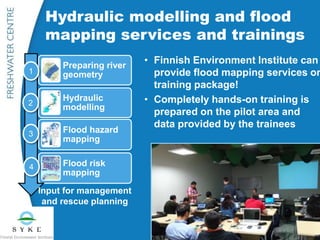
- 1. • Finnish Environment Institute can provide flood mapping services or training package! • Completely hands-on training is prepared on the pilot area and data provided by the trainees Preparing river geometry Hydraulic modelling Flood hazard mapping Flood risk mapping Hydraulic modelling and flood mapping services and trainings Input for management and rescue planning 1 2 3 4
- 2. From hydrological to hydrodynamic simulation and flood maps Discharge to the flood plain Hydrological simulation Temperature Precipitation Hydrodynamic simulation Water depth in the flood plain Discharge and water level observations Flood risk map
- 3. Preparing river geometry (~2 days) • Assembling of the hydraulic model geometry from the river bathymetry and floodplain elevation data e.g. based on digital elevation model • Tools: ArcGIS or QGIS (open source) and HEC-RAS (available free of charge) Hydraulic modelling (~5 days) • Preparing the HEC-RAS model based on the geometry, 1D or 2D-modelling (optional analyses: dam breach, river ice, lake regulation) • Calibration of the model and simulation of the desired scenarios, inc. uncertainty analyses The specifications of the examples of the hands-on training packages 1 2
- 4. Flood mapping (~3 days) • Producing flood hazard maps for different scenarios based on the water levels calculated by hydraulic model and elevation model • Finalization steps • ArcGIS or QGIS software Flood risk mapping and publishing the maps (~4 days) • Combining flood hazard zones with vulnerability information and producing flood risk maps and flood damage estimations (statistics) • Publishing the flood maps as a map service + helpdesk between and after the trainings + step by step manuals 3 4
- 5. • Producing surface water flood maps for urban rainstorm floods • The hydrodynamic model based on time dependent precipitation and elevation model as input data • Powerful computing • SYKE produces pluvial flood maps for all urban and suburban areas in Finland 2017-2018 Modelling and mapping for pluvial floods
- 6. Recent references • Andean countries, 2016 • Latvia, 2015 • China, Guoandong, 2014 • Georgia, 2012-2014 • Several trainings in Finland More information: environment.fi/floodmaps floodmapping@environment.fi