

Recommended
More Related Content
Similar to Detian waterfall
Similar to Detian waterfall (20)
More from Journey Han
More from Journey Han (20)
Recently uploaded
Recently uploaded (20)
Detian waterfall
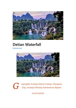
- 1. G Detian Waterfall eographic location:Daxin County, Chongzuo City, Guangxi Zhuang Autonomous Region Level:AAAAA hanjourney.com
- 2. Famous scenery:Sino-Vietnamese border 836 boundary pillar Suitable for the play season:Best summer Detian Waterfall is located in Detian Village, Shuolong Town, Daxin County, Chongzuo City, Guangxi Zhuang Autonomous Region. It is on the upper reaches of the Guichun River at the border between China and Vietnam. The waterfall is magnificent and spectacular, and it is adjacent to the Vietnam Banjo Waterfall (“Bản Giốc & Đức Thiên”) is the largest trans-Asian waterfall in Asia and the fourth largest in the world. The average annual water flow is about three times that of Guizhou Huangguoshu Waterfall. It is a national AAAAA tourist attraction in China. It is also a location where “Liquor is Hometown Alcohol” and “Hua Qian Bone” is amazing and wonderful. In January 2016, the National Tourism Administration and the Ministry of Environmental Protection proposed to identify the Dade Tianjing District of Chongzuo City in Guangxi Autonomous Region as a national ecotourism demonstration zone. On October 17, 2018, the Ministry of Culture and Tourism announced that it would meet the national 5A-level tourist scenic spot standards and propose to make public announcements for the national 5A-level tourist attractions. Among them, Detian Waterfall is listed. Geological formation The stratum of the Detian Waterfall is mainly the Middle Devonian dolomitic limestone, which is a typical karst waterfall. The upper reaches of the Guichun River flows through Vietnam. This section of the river is a branching channel with a wide river bed, Duojiang Xinzhou and Xintan. When approaching the Detian Waterfall, the height difference between the river bed at the lower reaches of the waterfall and the river bed at the top of the waterfall is about 6 meters. The river is the shortest path to reach the downstream water
- 3. surface, causing the water flow of the Guichun River to take the road in the dolomite buds in the upper riverbed of the waterfall. It forms a stone bud island such as Puyu Island. These river islands divide the river into a number of streams that flow from different parts to the cliffs of the waterfall, causing the waterfall to be multi-bundled. Rock nature The falling water cliff at Detian Waterfall is the dolomitic limestone of the Middle Devonian Donggangling Formation, while the bottom of the waterfall is the siltstone and mud of the lower Devonian gray- green, yellow-green, and yellow-brown. Clastic rock formations such as siltstone and shale. Clastic sandstone, argillaceous siltstone, shale and other clastic rocks have poor erosion resistance and are easily eroded by water flow, while dolomite is highly resistant to water erosion and erosion, and the slope composed of thick layered dolomite is stable, although Dolomite can be dissolved by water, but its dissolution rate is slower, far less destructive than the erosion of water flow, and the solubility of dolomite itself is not very strong. In addition, the dolomite is more resistant than sand shale, and the waterfall water erodes the base of the cliff, and the bottom of the cliff is hollowed out, causing the steep cliff to collapse and collapse. Therefore, the most concentrated part of the water flow is the most erosive part (mostly a waterfall). The central part of the cliff has more retreats, as is the Detian Waterfall. For example, the fourth
- 4. stage of the waterfall has a chair-like shape, and the first-level waterfall is the same. Rock formation The site is located in the west wing of the Sichengling anticline, the Guichun River is controlled by the northwest-south east direction structure, and the faults in the northeast-southwest direction are also active nearby. Under the influence of these fault activities, the occurrence is gentle (5°). The thick layer dolomite joint fissures of ~8°) develop, and the water flow uses the joint fissure as the channel for its own migration, and expands these fissure surfaces, so that the rock formation forms a steep cliff along the fissure surface. In addition, due to the relatively developed layer cracks in the rock formation, the upper rock mass is easily damaged, thus forming a multi-level cliff and multi-level waterfall surface. At Detian Waterfall, Dolomite is located on the upper part of the siltstone with poor erosion resistance and upstream of the first water. At the same time, the formation of the rock layer is gentle, so that the water flow can be distributed smoothly on the steep cliff surface, which is easy to form the waterfall surface. More wide waterfalls, such as Detian Waterfall.
- 5. Structural features The natural slope of the Guichun River Valley is relatively large. The flow from the Putang Island to the Loudi Power Station in the upper reaches of Detian Waterfall is 18.93 kilometers. The water level falls by 190 meters, the hydraulic slope drops to 1%, and small water falls in the river valley. The flow rate is fast, and it has a strong erosion effect on the bottom of the river, which is conducive to the formation of the waterfall. The Detian Waterfall Cliff was originally a crack in the river and gradually developed into a spectacular waterfall due to the difference in lithology.
- 6. Water flow The flow of the Guichun River is relatively large, and the average annual flow rate is about 50 cubic meters per second. It has a strong erosion effect on the riverbed and is beneficial to the formation of the waterfall. Morphological characteristics The returning area of the Guichun River is about 2,200 square kilometers, of which the rainfall area in Vietnam is 505 square kilometers, with an average annual flow of 55.20 cubic meters per second. The return of the Guichun River bed is 243 meters. The largest of these is the Detian Waterfall, which forms a four-level natural waterfall. Detian Waterfall is 100 meters wide and is divided into three levels of waterfalls. The vertical height is more than 70 meters. It originates from Guangxi Guichun River and has water all year round. Detian Waterfall is connected to the Banjo Waterfall in Vietnam. The two waterfalls in the rainy season are integrated into one, with a total width of 208 meters.
- 7. Natural environment Detian Waterfall is located in the upper reaches of the Guichun River in Daxin County, about 50 meters away from the border pillar of China-Vietnam border. The clear Guichun River is a tributary of the Zuojiang River and the border river of the Sino-Vietnamese border. The Detian Waterfall is a masterpiece when it flows through Putang Island. The mighty returning spring water flows from the north, and the high cliffs of the three-storey Putang Island are screaming and swaying. The river rises down from the cliffs of more than 50 meters and hits the rock. Splashes of water, misty fog, distant looks like squatting, close-up view like flying beads splashing jade, through the refraction of the sun, colorful, the sound of the water, the river valley, the momentum is very strong. The waterfall falls at three levels, with a maximum width of more than 200 meters, a depth of more than 60 meters, a drop of more than 70 meters, and an average annual flow of 50 cubic meters per second. The geology of the site is thick layered dolomite. It is the largest natural waterfall in Southeast Asia and has been designated as a special attraction by the country. It is connected to the Banjo Falls in Vietnam, like a pair of close sisters. The Chinese and Vietnamese border people are carrying out border trades in the lower reaches of the waterfall. They used to be shoulder-to-shoulder.
- 8. History and culture In a place bordering Vietnam in the southwestern border of China, the Guangxi Zhuang Autonomous Region does not know when it will flow from a clear river. No matter the four seasons, she is always green and clear, and she is as simple as a girl in the mountains. People give her A beautiful name – Guichun River. The Guichun River flows quietly to Vietnam, and then wanders back to Guangxi. In the end, it is in the small town of Shuolong. After a long silence, the power broke out instantly, breaking through the thousands of rocks and rushing out of the blockade of the high cliffs and green trees. The border between China and Vietnam has been drawn. Perhaps it is the nature of nature. The sag of the river hangs down from the cliff of more than 60 meters, hitting the layers of rock, the stream is winding, the water is splashing, the water mist is lost, and the distance looks like a sag. In the sky, the close view is like a flying bead splashing jade, through the refraction of the sun, the colorful, the sound of the water, the river valley, inadvertently formed another fascinating miracle: the world’s fourth, Asia’s largest cross-country waterfall – Detian Waterfall. Therefore, from the day when the Detian Waterfall was created, it became the most passionate expression of Guichun River. Detian Waterfall is connected with the Banjo Waterfall in Vietnam. It is like a pair of close sisters, Tingting, standing together. The eyes pierced the misty mist, and I saw the Iraqi people. On the water side, the waist wrapped around the spring river like a jade belt, and the first hair fell to the Chaohu Lake. Eyebrow teasing. This is really a poetic romantic and elegant place, step by step is the scene,
- 9. everywhere is affectionate. People are among them, if you paint in the middle, there is no side to heart, no dust. I only want to find a green grass, where the torrents are, cover a thatched house, plant a few peach trees, plow a few acres of land, and watch the flowering branches burning, imitating the elegance of Tang Caizi. Hold the hand, set the wine cellar and the hermit. Honors On October 23, 2005, China’s most beautiful local rankings were released in Beijing. The event was hosted by China National Geographic and co-organized by the 34 media outlets in China. The “Best Place in China” selection campaign lasted for 8 months, and the “Expert Group”, “Media Group” and “Network Phone” were selected. Popularity group three categories of awards. The “Media Group” and the “Popular Group” each produced 12 award-winning places in the form of media voting and voting by netizens and mobile phone users. The “Expert Society Group” awards, which were launched by China National Geographic magazine, are unique. They are divided into mountains, lakes, forests, grasslands, deserts, Yadan landforms, islands, coasts, waterfalls, glaciers, canyons, urban areas, rural towns, There are 15 types of tourist caves, marshes and wetlands. Among the six most beautiful waterfalls in China, Detian Waterfall is among them.
- 10. On October 17, 2018, the National Tourism Resources Planning and Development Quality Evaluation Committee made a public announcement, and it was proposed to identify 9 scenic spots such as the Chongzuo Detian Transnational Waterfall Scenic Spot as a national 5A-level tourist scenic spot. Tourism Development Tourist route Every day at 9:00 am, there is a tourist express bus departing at Fengling Passenger Transport Station (next to Nanning East Railway Station). The whole journey takes the expressway, and it takes 3.5 hours to reach the tourist center of the scenic spot. At 4 o’clock in the afternoon, it returns to Nanning from the scenic spot. Every day at 9:00 am, there is a tourist hotline at the Nanning East Railway Station, which can go directly to the gate of the scenic spot. However, there are restrictions on time and must be returned at 3:30 pm. If you can’t catch up, you can take a bus to Daxin County Bus Station. Every day, there are many trains from Nanning Peking University Bus Terminal to Daxin County. After arriving in Daxin, they will transfer to Detian Scenic Area. The German antenna is a relatively mature tourism route. The day
- 11. trip from Nanning is usually between 7:00 and 7:30 in the morning. The price is about 200 yuan. It is convenient to go directly to the scenic spot. The price of the two-day tour ranges from 200 yuan to more than 500 yuan. All-inclusive and half-packages are available. Generally, the Mingshi Garden or the Tongling Grand Canyon will be visited on the basis of Detian Waterfall. Self-driving tour From Nanning, take the 324 National Road (Fuqian Line) westbound to Tanlu and turn left to Daxin, go to Shuolong Town, and then go for more than 10 kilometers. The scenery is bright and there are eye- catching tourist directions along the road. The card leads the way. In particular, driving along the Heishui River, Mingshi Garden, that list of pastoral, Duxiu Peak, Wuzhifeng, Xianshan Yaochi, water stone forest and many other beautiful scenery is known as the “Grand English Club Detian”, let people walk in the landscape gallery The true feelings in the middle. Fare Adult fare: 80 yuan / person; children: height 1.2 meters – 1.5 meters (including 1.5 meters): 40 yuan / person, height 1.2 meters (including 1.2 meters) below free; Daxin local tourists tickets: 10 yuan. Tour time The best time to visit Detian Waterfall: From June to November every year, the water is large and the water quality is clear due to the rainy season. It is the best time to enjoy the waterfall roaring like a horse. The Detian Waterfall has plenty of water in the summer and the surrounding vegetation is lush. From December to May, it is a dry season. During this period, the amount of water in the waterfall is small, and the earth and stone in
- 12. the waterfall are more exposed, and the viewing effect will be greatly reduced.